Astronomers think they have found the 10th rock from the Sun. Naturally there is still a great deal of argument about this, but there seems to be reliable word that a body at least 1.5 times the size of Pluto has been found in the Kuiper Belt. It is estimated at 2,100 miles in diameter, and revolves around Sol at 97 a.u., about three times the distance out than Pluto (and a.u., or astronomical unit, is taken as the distance from the Earth to the Sun). Its orbit is inclined a surprising 45 degrees from the plane of our own, which is one reason its been so hard to find.
Yahoo sums up the breaking news from Space.com in this story.
Persephone is the name sf writers have floated from time to time as the next major planet to be found out from Pluto, if one should exist. It falls neatly into our theme of naming planets for the Greek pantheon; she was queen of the underworld in the Greek mythos and formed the mythological basis for the changing of the seasons, as she spent six months in the underworld and six months up top. James Blish, in the Cities In Flight cycle, called this notional planet by its Roman name, Proserpina.

By Samuel John Klein of Portland, Oregon - Graphic Designer without Portfolio, aspiring artist who dawdled too long.
30 July 2005
[geography] The Address Nerd Gives You A Handy Chart
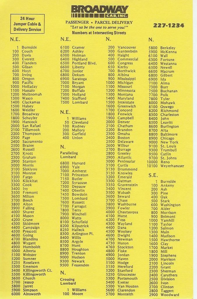 The thumbnails at left and below should click and expand into a handy dandy little guide to help you get around our fair Rose City.
It is referred to, somewhat unfortunately, as the cheat sheet. Broadway drivers carry them. I believe Radio Cab prints thier own version.
It's no secret internal document or salacious peek into the world of the cab driver. All it is, is a list of streets in Portland, and thier 'block numbers'. It is a bare-bones index listing of streets, a basic textual description of the city's skeletal structure.
To understand how to communicate with this list, meditate well on the boldface subtitle below the Broadway Cab logo: Numbers at Intersecting Streets.

Take side one, the section headed "N.E". This list starts with 1 Burnside, then continues 100 Couch, 200 Davis, 300 Everett, 400 Flanders, 500 Glisan all the way to 7500 Lombard. Now picture yourself heading north on NE Grand Avenue from Burnside. You've just crossed the intersection of NE Davis Street. You're going north, and if you've paid attention to the lessons so far, you know numbers are increasing, therefore, you know you're entering the 200s on NE Grand. If you're traveling toward a baseline, say southbound on NE MLK Jr Blvd, the numbers go down; if you're crossing NE Davis going south on MLK, you know now you are leaving the 200s on NE MLK.
The whole thing is just that simple. Now you know how to interpret those block number tabs on the street sign: when you're at NE Glisan and 60th, say in front of Biddy McGraw's, and you're telling someone where you are, you, dear God, don't say you're at "500 NE Glisan St". You are now enlightened. Carry this gem whereever you go in Portland, Glisanhopper, and don't get lost.
Even though the layout and design are rather straightforward, there are a few points worth noting. For instance, the NE list ends at 7500-Lombard, which as can be easily seen from the map, is hardly the edge of the city. For streets north of Lombard, check the section labelled "N" and subtitled "Parallelling Lombard". Find 7500-Lombard in the list–a few of the streets from 7600-Russett north have NE counterparts. As for the streets south of Lombard and parallel, most of those streets are unique to the peninsula area. However, NE streets have N counterparts as far east as Greeley Avenue, so the NE block numbers apply there.
Just after the end of the long NE list is a shorter NE list with 5 items–1-Williams, 50-Cleveland, 100-Rodney, 200-Mallory, 300-Garfield, 400-Union. These are actually named Avenues. From the Rose Quarter area north to Columbia Blvd, instead of numbers, the Avenues in that area have names. These are thier intersecting block numbers.
The N (Crossing Lombard) list serves the Peninsula as well as areas south–out to about Interstate, N named Avenues extend as far south as the Rose Quarter (notably Williams and Vancouver).
Even Zero Hundreds are accounted for-but that list is very short as well, leaving off at 0600-Moody.
The list, then, isn't all-inclusive. It includes the straight streets only (a listing including all the curvy streets in Healy Heights, Council Crest, etc, would be a book, providing it could be so designed as to communicate clearly). This card is a good shorthand reminder if you know the city well, a map companion if you dont.
Two other areas deserve mention. The last two sections on Side Two begin with the heading "E. & W. Streets Crossing Sandy (and numbers on N & S Aves. At Sandy)" and "E. & W. Streets Crossing Foster (and numbers on N & S Aves. at Foster)". This bit of information design has always struck me as unassuming brilliance. Each has a list of names and numbers formatted thus: 16 Davis - 200 (for the Sandy list). You read it thus:
As you are travelling on Sandy Blvd and cross NE 16th Avenue, you are also crossing NE Davis Street, which is the 200 block on 16th. Similarly, in the Foster list, 63 Holgate - 4500 means that as you go down Foster Road and pass SE 63rd Avenue, you are also crossing SE Holgate Blvd, which is the 4500 Block of 63rd.
Nifty, eh?
The cards might be available from a cab driver, or you can probably phone Broadway Cab and ask them to send you one. If you don't know what Broadway Cab's phone number is, you should get out more. Here's a challenge: CApitol7-1234. Figure out what goes in place of the C and the A. Don't forget the area code.
Please also note, while the Broadway Cab logo is included on these cards this is not to be construed as an endorsement or opinion, one way or the other, on Broadway Cab.
29 July 2005
[geography] The Address Nerd Visits Clark County Cities
This is essentially part 2 of this post.
In that post I did a sort of grand tour of Washington's Clark County, commenting on the address baselines definition, the Vancouver rationale, and how it extends into the county and that even though the naming systems seem different the county grid is actually an extension of the city grid.
Clark County has a handful of outlying cities: Ridgefield, La Center, Battle Ground, Yacolt, Washougal, and Camas. As distinct from many cities in the Portland metagrid, each one of these cities has thier own internal address and street name systems, with no exception.
Ridgefield
Ridgefield is located along the Lake River, a "yazoo" type that forms the outflow from Vancouver Lake to the Columbia River (which it itself joins just northwest of the town, near its confluence with the Lewis River at the NW corner of Clark County). It's reachable by car off I-5 exit 14, which is actually about three miles east of the center of town.
For a long time, Ridgefield's complete corporate area was a wedge-shaped bit of land less than a mile square straddling the Willamette Meridian in Township 4 North. The address and street name structure has always been simple. North-south numbed avenues increase east from the railroad which runs along Lake River, and Pioneer Street formed the baseline dividing the north from the south. Numbered avenues have simplex directions as prefixes (N 4th Ave, S 9th Ave), and Pioneer Street became NW 269th St at the city limits, connecting town to freeway.
Within the last 4 years, Ridgefield increased its area on the ground many times. From a small patch of ground three miles west of I-5, the city has expanded to extend one mile east of it, and extended about a mile and a half south of Pioneer Street to encompass the Ridgefield High School Campus (at the intersection of what had been NW Hillhurst Road and NW Royle Road). Most of this new city land lays undeveloped as of yet, but urbanization can't be too far down the road.
With annexation of the new city land, all county-named roads within that area have been brought into the Ridgefield grid. In a small version of the Clark County method, the names of the older section of town have been preserved but the names of new streets in former county lands have been dubbed with numbers. Avenues, Courts and places increase to the east, Streets, Ways, and Circles increase north and south from Pioneer. Roads that do not follow cardinal directsions retain word-names, the names they had as county roads, prefixed N or S as appropriate.
The result is very high numbered streets in a small town, which is a strange thing to see. For instance, what was called NW 31st Avenue is now known as N and S 45th Ave-this is between Exit 14 and central Ridgefield , less than 1 mile west of I-5. The former NW 269th St has been renamed to Pioneer Street all the way out. Just west of I-5 traffic is diverted down S 65th Avenue (renamed from Clark County NW 11th Avenue) onto S 5th Street (formerly NW 264th Street) which intersects S 77th Place and S 78th Place before it ends at Clark County's NE 10th Avenue (which, since it is on the city-county boundary, has apparently not been renamed to S 85th Avenue, which would be its logical city name).
Most of this area remains farmland, which means that a map is useful to see the pattern. The new streets are spaced fairly far apart, and the pattern may not be terribly obvious on the ground.
La Center
La Center is just a few miles northeast from Ridgefield, and is reachable from I-5 exit 16. The road leading into it was once called NW 319th Street until it started to curve to enter the town. This has since been changed, and NW 319th Street has inherited the name NW La Center Road for its entirety east from I-5 into town.
One enters La Center proper after crossing the bridge over the East Fork Lewis River, approximately 1.5 miles off the freeway. The main road (the old Pacific Highway 99) nicks off a slice of the west part of town and slides quickly out enroute to the Lewis River bridge into Woodland.
As many Clark County cities have, La Center has grown too, though not as much as others. It has grown by about a factor of two, however, and has added in enough new land to plat a large new subdivision on the towns northeast side.
Generally speaking, numbered streets cross named streets. East of the dividing line, Aspen Street, streets name in alphabetical order after trees: Birch, Cedar, Dogwood, Elm. West of Aspen the streets are lettered: A, B (Pacific Hwy), D, E, F, G. Not every street was developed on this side, and the pattern breaks down fairly quickly.
Observation of the map shows two different textures to town. South of 10th Street, there is a regular gridiron, moreover, the west is at a steeper tilt than the east. North of 10th Street lays the big subdivision plat, easily distinguishable by its lazy curves and loops. The numbering pattern is logically continued even if named streets are not; the highest-order numbered street is E 18th Street, adjacent the north city limits.
The 10th Street transition line is important for another reason; 10th Street is laid out along an important line in the Public Lands Survey for this region, the First Standard Parallel North. A complete description of this is a bit off topic, but quickly, this line is necessary because the Survey is a flat grid laid out on a big ball. As you go north, those Range lines tend to converge. The east-west spacing is resurveyed at the Standard Parallels, which usually space off at 5 townships north and south of the baseline.
The Town of Yacolt
This is perhaps the most backwoods corporation in the county. You reach it by going out SR 503 (NE Lewisville Hwy) to Rock Creek Rd/Lucia Falls Road, which by what I understand is a very picturesque drive, will lead you into Yacolt from the south. No state highways lead to Yacolt. It is about twelve miles exactly east of La Center along the First Standard Parallel North.
Of all the cities in Clark County Yacolt's growth has been the most modest growth-almost none, in terms of territory. Its city limits have changed very little in the last 10-15 years.
And, in contravention of the urge of all cities in this area which strive to have some sort of system of numbered streets and avenues, Yacolt has none. N-S avenues cross E-W streets, but everything has a name, either proper names (Wilson, Jones), local landmarks (Amboy, Twin Falls) or functional names (Railroad). The divisional system is similarly simple, with simplex directional prefixes of N, W, E, and S based on the divisional streets of Railroad Avenue and Jones Street. Railroad Avenue runs NNW-SSE, at a slant, but the spread of the town is limited enough that this doesn't become a logical house numbering issue.
East and West Yacolt Road is laid out on the First Standard Parallel North, meaning it lines up exactly with 10th Street in La Center.
Battle Ground
This is another quadranted town with numbered Avenues running N-S cross numbered Streets running E-W.
It was not always thus. Ten or fifteen years ago, when the town had less area and less population, named Avenues crossed numbered streets. at some time during the last five years or so, the decison was made to toss all street names in the dustbin in favor of numbers, with just a handful of exceptions (notably, Clark Avenue, Grace Avenue and Fairgrounds Avenue; Rasmussen Blvd and Scotton Way in the south part of town, Onsdorff Blvd in the north).
The dividing streets are still N and S Parkway Avenue and E and W Main Street. they simply divide the town into duplex directionals (NW, SW, NE, SE) which are street name prefixes. The highest-order numbers in town are NW 29th Ave on the west, NW 24th Street on the north, NE 20th Avenue (off county's NE Heisson Road/229th Avenue) on the east, and SW and SE 18th Street, intersecting South Parkway Avenue just north of that street name's termination at NE 199th Street-Battle Ground's south end.
State Route 502 comes into town from the west end to become West Main Street: State Route 503-Battleground's direct connection to the I-205/Fourth Plain/Vancouver Mall area-comes into town from the south with the County name of NE 122nd Avenue and leaves town as NE Lewisville Highway, but while inside the Battle Ground city limits is known as NW and SW 10th Avenue.
Camas and Washougal
Camas has grown prodigiously on the ground much as Vancouver and Ridgefield have. From a modestly-sized town in the 80's that pretty much hugged the Columbia right bank it has exploded up the bluff to become a large wedge-shaped piece of land which now extends along the whole of the south shore of Lacamas Lake, and whose city boundary extends north of County's SE 1st Street-some four miles north of the river.
New development in the annexed areas has been named and numbered as an extension of the city's original grid.
The center of Camas is interesting because it sits at such a severe angle to the rest of the city. Established on a relatively level bit of land immediately north of where the Washougal River enters the Columbia, it runs at nearly a 45 degree angle from the cardinal. So great this angle is that, at the east end of the old town, NE 6th Avenue nearly intersects NE 19th Avenue, which is extended eastward from the cardinally aligned streets on the bluff overlooking the older part of town.
Regardless, this skewed grid forms the basis of the Camas addressing and numbering system. East-west numbered avenues intersect named north-south streets arranged alphabetically. The baseline running east is 1st Avenue, the baseline running North is Division Street.
A look at the map brings a notable feature out-there are a great many geographical discontinuities which make the Camas system a matter of logic and design. The skewed old town I already mentioned; north of 7th Avenue the bluff rises and the streets straighten out, and on the west end of city center the paper mill (what is it these days, James River still? I go back far enough that I still think of it as Crown-Z) prevents 1st Avenue and Division Street from physically meeting. Washougal River cuts off a tongue of land on the southeast side, and the system as a whole seems to preclude any SW prefixed addresses at all. But the system was established along those baselines, and the planning has been admirable consistent along those lines.
The baselines of Division Street and 1st Avenue logically divide the space into four quadrants, duplex directional, NW/SW/NE/SE , prefixed (the SW is dubious, as I mentioned, and I'll detail it presently). The geographically isolated SE section's name is determined by virtually extending East 1st Avenue along the Washougal River and probably estimating what those streets would be if something was physically extended from the center of town. West of city center all land is NW except for a sliver of land between State Route 14 and the Camas Slough shore, where a small district of land is prefixed SW and numbers increase from SR 14 toward the river. NW 6th Avenue crosses into this area and becomes SW 6th Avenue.
Because of the geographical problems inherent in the layout, following along with a map is recommended, if not required.
Camas and Washougal link up on Camas's east end like Camas is docking with Washougal. The center of Washougal is a reguarly gridded area about 1/2 mile east of where the two cities abut. The address and street name system of Washougal is essentially based on the easternmost point of Washougal south of the Washougal River, where you can find 1st Street. Thus, the historic central section of Washougal starts with 9th Street and extends east to 22nd Street.
Numbered streets progress west to east, lettered streets south to north. There are no directionals in the original city area, which is the part of the bar of land between the Columbia and Washougal Rivers not in Camas.
Since Washougal has grown, however, it's sprawled a little south (the floodplain of the Columbia provides an area for industrial growth; the area north of SR 14 and east of 32nd Street has provided room for residential growth. Latterly, growth has also included land north of the Washougal River and west toward Camas.
These extensions have logical extensions as appropriate. Any street south of A has a name but and a directional of S (S Ford St, S Index St), and any numbered street extending south of A is similarly prefixed (S 32nd Street). The geographic pocket north of the Washougal River has street names and numbers and addresses logically extended but evething in this area (just off Washougal River Road) is prefixed N (N M Street, N 24th Street). Even more interesting, the area of Washougal north of the river and west of a logically defined notional 1st Street extension north of Washougal River is prefixed West (an actual 1st street wouldn't quite line up correctly). The extent of this developemnt is a small subdivision off NE Crown Road (reachable from NE 3rd Street in Camas) with street names such as West Lookout Ridge Dr and W Y Street, W Z Street, and West 9th and 10th Streets.
The extension of Washougal east and north has a few named streets but largely extends the scheme of numbers and letters established in the original areas of the city. The highest-order numbered street I can find currently in Washougal is 57th Street.
[pdx_media] Mike Donahue and A Very Personal Admission
Mike Donahue, stalwart of local media, Mr Newsroom 6, and the Portland area's closest thing to Dick Clark, has made a public statement: it would seem he has signs of prostate cancer.
Last night I watched what was apparently part two of a three part report on his diagnosis. Prostate cancer is a scary thing, when I think about it. It seems to be the only cancer that men risk whose probablilty approaches 1.00 if a dude lives long enough.
So Mike, in the tradition of all those who want to advise those with a risk of how to prevent a totally preventable thing, is going public with his own story of diagnosis and standing on the brink on how to attack it.
This story on KOIN.com is a version of what he said on the air. It's worth reading.
Mike, I may not amount to too awful much, but I grew up watching you on the air and you're still my favorite newsguy. I'm pulling for you.
If I understand correctly, the chapter of his story detailing his opportunities for treatment run tonight. I plan on watching it.
28 July 2005
[pdx_history] Abysinnia, Meier & Frank
Jack Bogdanski is taking a comment hiatus, so I can't leave a comment on his 'blog. However, If I could, I'd respond to this post kinda like this:
I remember spending a short period of my life in Idaho Falls (as Idaho Falls, so falls Idaho Falls) and I remember a department store there, one that seemed to have branches in Utah and southern Idaho (or as I like to think of it "far northern Utah").
It had the cryptic and improbable name of ZCMI. A sort of mystery like that doesn't lay down for long, so I eventually (through casual research, mind) found out what that stood for and how it started: it was ZCMI was acronymical for Zion's Cooperative Mercantile Institute, which began in Salt Lake City as a cooperative association for local residents to sell thier wares.
Of course the ZCMI I visited in IF was hardly a cooperative, it was very much the model of a modern department store-kinda like Meier & Frank. One can only imagine my bemusement when I heard that, back in the '90s, Meier & Frank bought out ZCMI. The thought of a M&F store in Idaho Falls struck me as funny for some reason, even though I had visited the IF Fred Meyer store (north end of the Northgate Mile) and was relieved to be able to pretend that, just for a little while, I was back in the Valley.
It hadn't occurred to me to think how local IFers might have felt about losing a local name. I suppose now I know.
I look upon the departure of a long time Oregon stalwart (in name, anyway) with a bit of equanimity, I suppose. It moves me, but not much. I grew up east of Salem, in the small town atmosphere of the hilly side of the Valley; we only went into M&F occaisionally, and only then for the school-clothes trip. It was something that advertised in the paper, but not something we bought from often. Also I was born as the old glory days of M&F in downtown Portland were well on the wane-I only heard of the Friday Surprise as a tradition reincarnated a few years back as a promotion, and the tradition of family trips to M&F on Sundays to be seen in the diner are, to me, born as a downstater, something of a legend only.
Really, big corporations buying out and extincting local names are such a part of my existence that I note them in passing; I'm pretty numb of it by now.
Still, goodbye, Meier & Frank. I will miss you, and Gerry Frank will have to work that much harder to explain just why the heck he's famous.
[logo_design] A Brief History of the Starbucks Logo
One thing: it's not a mermaid. As SCA heralds know, it's a melusine, which is essentially a mermaid with two tails, sure, but it's not a mermaid, at least not strictly speaking.
Hit during a night of desultory blog-browsing, DeadProgrammer.com, in this entry, gives us a little history of the Starbucks logo. Interesting, though those with kids should be warned; this contains reproductions of mythical femail creatures with bare breasts. You have been warned.
The brief lessons of design that can be found here are thus: It is said the name Starbucks was inspired by Capt. Ahab's 1st mate, from Melville's Moby Dick. The connotations here are shipping and merchant marine from the 19th century, when far off lands were really that way and everything seemed mythological and fantastic, when the world was a bigger place. Coffee came from overseas and is still a world trade item. What we have here is a logo setting a tone.
Another important idea is simplification. Beyond the "politically correct" move of obscuring the bare breasts and belly button/suggestion of naughty bits, this is actually sound design. The rendering of the woodcut-style illustration into a simpler, iconic style eliminates fine detail which can get obscured, or disappear entirely if reduced to small business-card size, Moreover, the older version is a little scary-the newer version retains all the associations that are desired but is more publicly-palatable.
That may seem a little cynical, but look at it this way: a design is a tool, no more or less imbued with teleological imperative than a safety pin, a hammer, or a saw. They can all be used to injure or to benefit. The key in constructively interpreting the message a logo sends is to have knowledge of the company using that logo; a logo can express and define a company's message, but a company isn't a message, it's a company. It is what it is. Now, more than ever, in this cosnumer-obsessed society, caveat emptor.
27 July 2005
[design] Good Design on a CD ROM?
 The ad was mailed to me by some spammer-who knows who any more-proclaiming the truism that "GooD DeSigN is GooD BusiNesS".
Ah, indeed.
You want a corporate identity? Want some "excellent corporate logo for company"? Wish to design your website?
The mailing is an oxymoron. Maybe good design is good business but, as sure as anything, you won't get good design by buying a CD-ROM full of design templates that come from God knows where.
Over "1000 logo's" for your corporate identity? This is offensive-if you want a logo that really belongs to you, it has to be designed with and for you. If this is a design school, it's the "lets throw it all up against the wall and see what sticks" school.
Of course, charmingly ensconced at the bottom of the email is an opportunity to opt-out of future mailings, which is actually a way of telling spammers you are a live address.
I mean, geez.
[metro_transit] C-Tran is Changing
 Since I was talking about Clark County, I thought about C-Tran, since transit is also one of my hobby-horses (it dovetails nicely into my continuing interests in maps and design). They've been going through some struggles lately, and there's been developments that show the direction they're pointing, at least for now. Here's what I've found out.
First a quick back story. In 2000, C-Tran lost 40% of its funding. C-Tran responded to this by elminating most rural service. In November 2004, C-Tran ran Proposition One up the flagpole, a sales tax increase that would have restored a 2000 level of service; a majority did not salute. C-Tran responded by planning to implement changes that would reduce service by a further 46 percent. Cited as prospective changes were the elimnation of service outside the Vancouver city limits, reduction of evening service, and elimination of all weekend service and fixed-route service in Camas-Washougal, Battle Ground, Ridgefield, Yacolt, and La Center.
Right now the district is implementing a change to the taxing and service boundary. When approved by voters in 1980, the C-Tran service and taxing area included the whole of Clark County. The district, in March 2005, approved a drastic reduction to those boundaries, to the Vancouver Urban Growth Boundary and the city limits of Ridgefield, La Center, Battle Ground, Yacolt, Camas, and Washougal. The latter two cities and Vancouver are contiguous and amount to one continuous service area; the four former cities, not contiguous to the other three, are connected to them by what C-Tran calls "non-service" transportation corridors-connecting express routes between these areas where no stopping for loading or unloading happens.
Here's a map (courtesy of C-Tran) that describes the new boundaries.
Service within those outlying communities is changing to what is being called "innovative" service. This was pioneered by what was known as "The Connector" (download 150KB PDF from C-Tran here), which amounts to flexible demand dial-a-ride service serving the northwest Camas area, similar to what Tri Met has been doing in Cedar Mill for the past couple of years. As implemented in the Service Preservation Plan, each of the four outlying communities would recieve "Connector"-style service, becoming flexible-demand non-fixed route service enabling local residents to get to a transfer point in town where they could then board an express bus route taking them into Vancouver.
C-Tran is going to be asking voters for a sales tax increase in the near future of 0.02 percent. All changes-including all necessary reductions in service and coverage-are to be implemented on 25 September 2005.
Details on the C-Tran Boundary Reductions can be found at this link.
Details on the C-Tran Service Preservation Program, including a thumbnail of what C-Tran service on the ground is expected to look like, can be found at this link.
[geography] The Address Nerd Does Clark County, WA
Clark County has been in my sights for a while because of its amazing growth. From a combination of in-migration and (largely) annexation of large swathes of formerly-unincorporated land to the east and (soon, I hear) to the north of town, Vancouver stands ready to pass Spokane as Washington's third largest city and, perhaps, in the near future, to challenge Tacoma as Washington's second-largest city. It's current population is about 145,000 (2000 census counted 143,560). It would take 3 and 3/4 (approximately) Vancouvers to make one Portland, but it is just about level on with Salem (143,000 approx) and Eugene (142,000 approx).
Vancouver, meanwhile, has gone from having a population of about 43,000 in the mid 80's to 54,000 in the mid 90's. The growth of all incorporated territory of almost every city in the county has been remarkable. I can't find exact figures for Vancouver's incorporated area, but in the late 80's I'd estmate it at 30 square miles, more or less. These days it covers (eyeball estimate) about 60 square miles, has about twelve miles of Columbia River's right bank, and stretches from 2/3rds of the way around Vancouver Lake on the west to touching Camas on the east. One other observation worth noting before I move off this digression is that if Vancouver City annexed all land within its Urban Growth Area (analogous to the Urban Growth Boundary in Oregon land-use planning) it would be Washington's 2nd largest city (275,000) in population, but largest (about 100 square miles, beating out Seattle by about 16) in area. If this sort of stuff turns you on as it obviously does me, the City of Vancouver has an annexation section of it's city website with maps, diagrams, and other annexation goodness here.
Now, down to business.
The greater Clark County address and name grid radiates from Vancouver. Specifically speaking, the spot where, notionally, 1st Street and Main Street would meet, at the south edge of downtown Vancouver.
This spot is, however, virtual. Due to geography and development, 1st and Main never come together. If they did, though, it would be right about at a spot just to the east of where the north end of the Interstate Bridge is. Keep this point in mind. I'll be returning to it.
Viewing the greater map of Clark County it becomes apparent that (disregarding the smaller cities in the county for now) there are two flavors to to Clark County Street names. In the older areas, adjacent to downtown Vancouver and Fort Vancouver itself, a simple form is followed. Going west from Main, parallel streets wear names and are alphabetically arranged (after Washington, which could be B Street if Main is taken as A, there are Columbia, Daniels, Esther, Frankln, Grant, Harney, Ingalls, Jefferson, Kauffman..at which point the pattern breaks down. Going east from Main, and again taking Main as A, Broadway occupies the B Street East position, then letters of the alphabet going out to Grand Blvd.
After that, there is little obvious organization aside from themes within the subdivisions themselves. The area along MacArthur Blvd, south of East Mill Plain Blvd, for example, has a decided World War II flavor, where states cross cities with the occaisional aircraft carrier and Pacific battlefield names sprinkled in.
Going north from the foot of Main Street we have the familiar numbered sequence, 2nd, 3rd 4th, etc. Differentiation across the division is provided by a simplex directional (east or west) appended to the street name. Three named streets stand in for numbere: Evergreen Blvd instead of 10th Street, Mill Plain Blvd instead of 14th/15th street, Fourth Plain Blvd instead of 26th Street. These names extend well beyond the central grid, serving as colletion routes between central Vancouver and near eastside and outer eastside areas, Mill Plain and Fourth Plain becoming particularly important boulevards.
North of 39th Street, Main doglegs to a more NE of east course before changing its name entirely (north of the I-5 overpass, the street is known as Highway 99). In this district the approprately-named Division Street handles the baseline duty.
But hang on there, you may be saying, at some point there is a change of rationale, and there are nothing but numbered avenues crossing numbered streets outside of the area you just named.
True that is. While it's obvious that the areas in Clark County north of Vancouver and in the eastern section of what is now the incorporated city have a different naming rationale than the older sections of Vancouver they are based off extensions of the same baselines-1st street and Main/Division-as the inner areas are. These baselines are virtual in places-the notional streets that define them are not continuous-and cut across neighborhoods.
But they are boundaries that can be observed on maps. Extending the line of 1st Street east, the vitrual line cuts right through the MacArthur Blvd/Andresen Road area, conveniently coincides with East Mill Plain Blvd from the 9700 Block to the 11500 Block (Chkalov Dr), and then is taken as SE 1st Street from that point (Mill Plain doglegs south of west) to the point where the street enters Camas at the 20200 Block-at which point it becomes NW Lake Road in the Camas system. Extending the Main-Division line north the demarcation is NE 1st Avenue (NE Hazel Dell Ave forms a convenient logical reference because so little of 1st Avenue actually exists on the ground, but it's approximately 1 block east of the actual division.
These lines divide Clark County into three areas named with a duplex directional in relation to the address origin in the center of Vancouver: NW, NE, and SE. Note also that, due the origin's physical location, a SW quadrant is neither practical nor possible.
The transition between inner and outer naming schemes is extremely loosely defined. About the only thing one can say for certain is that if you are south of 39th Street and West of Andresen Road then you are almost certainly in the simpler system. Outside of that, numbered Streets, Circles, and Ways progress north, and south from the 1st street/SE 1st St line, and numbered Avenues, Places, and Courts progress east and west from the Main/Division/1st Avenue line. In the Mill Plain-MacArthur Blvd district the inner scheme prevails as far east as the area round Lieser Road and St Helens St, though NE numbered avenues can be found west of there along Mill Plain Blvd in the neighborhood opposite SW Washington Medical Center (once known as St. Joseph's Hospital). In the area north of 39th Street and west of Division numbered avenues wear the NW label while named streets have none. And, even stranger, off East 13th Street between Grand Blvd and Brandt road there are two numbered avenues and one numbered place that fit into the Avenue scheme but are simply referred: East 32nd Avenue, East 33rd Place, and East 40th Avenue.
Named streets in the outer system are few and far between but are easy to find-they don't run cardinal north-south. NE Burton Road splits off from East Fourth Plain Blvd at the 7300 block and does a slight meander but as soon as it straightens out, at NE 112th Ave, the name changes to NE 28th Street. NE Ward Road forks off Fourth Plain in the Sifton area and meanders itself a bit but becomes cardinal at NE 119th Street, changing its name to NE 182nd Avenue. NE 134th Street and NE 139th Street are connected by an s-curve of barely 1/4 miles length called NE Tenny Road. There are more examples-they're yours for the finding.
The numbered streets and avenues attain thier own respectable magnitudes: there is a NE 434th Street in the Chelatche Prairie area of far northeast Clark County, and right along the Clark/Skamania line, off Washougal River Road, is NE 412th Avenue. NE Streets in the low 600s are possible, but since they are in the mountainous NE corner of the county, in what amounts to National Forest country, not at all probable.
The address grids of the individual Clark County towns deserve some mention, but noting thie length of this post, I think there will be a part 2.
25 July 2005
[design, tech] How-To: Filling Text With Pictures in QuarkXPress
If you're a Quarker and you have a design job that needs you to fill text with images, like this:
 Then go to QuarkVsInDesign.com and read Pariah S. Burke's quick, simple, and fun tutorial, here.
You'll wind up knowing more than you did before.
What? You haven't bookmarked QuarkVsInDesign.com yet? Why not?
 Then go to QuarkVsInDesign.com and read Pariah S. Burke's quick, simple, and fun tutorial, here.
You'll wind up knowing more than you did before.
What? You haven't bookmarked QuarkVsInDesign.com yet? Why not?
24 July 2005
[sundial_life] Random Personal Thoughts
I heart Stumptown Confidential
A sincere word to everyone who is following the accidental series "The Address Nerd...". Thanks everybody. It's turning out to be a ton of fun. We all, I suppose, have those things we like to obsess on, and then, later, it turns out you were busy finding answers to all the questions that everybody had but didn't really know they wanted to ask. I have that feeling now
Mad stoopid props to Scholckstar and the inimitable Stumptown Confidential, who posted an entry about my blabbing about my hobbyhorse and, consequently, attracting more visitors to my site than anything else I've done. Thank you, Schlockstar, and thanks, visitors. Your humble attention has made my days
There's more Address Nerdery to come. It seems that once I've gone over a topic there's another one I find I want to go over, or something I've overlooked. I have, amongst other things, a couple of treasured maps of Portland that date from the 1920's-1930's. These are wonders to see. Also, I have a collection of Portland maps that extend from that time to the present day.
And when I'm done with that, I have a bunch of maps from other cities whose plans fascinate me. I have, collected from various sources, somewhere between 500 and 1000 maps (if not more...I just gave up counting after about 500) of cities across America and around the world.
Research continues into Vitamin "R"
The consumption of rum is, as I've touched on from time to time, one of the occasional adult pleasures we adults around House SunDial take. We've found a couple of new ones that are quite delightful.
They're big name brands, which is all the more surprising. We've been through the Cruzan Estate Dark (aged 2 years) and found it worthy for mixing and sipping neat. But the big surprises were from two stalwart, somewhat pedestrian names: Captain Morgan and Bacardi.
Captain Morgan has a dark, sweet rum out ther called "Tattoo". It tastes a little like blackstrap but has a hint of berry...blackberry perhaps...in. Okay for sipping neat, better if mixed (with my personal favorites: Diet Dr Pepper and a bit of Blue Curacao (the blue is for the beautiful deep color you get when you shine a light through)). Moreover, C.M. Tattoo goes better with diet Vanilla Pepsi than regular C.M. Spiced does.
The other is Bacardi Vanilé. Simply, Bacardi white rum with vanilla. Sounds a bit facile, what with the current Bacardi and Absolut trend toward flavoring thier signature spirit with every essence under the sun, but unexpectly good. This one mixes well, but I highly recommend this one neat.
As always, drink responsibly. That means, don't drive, and if you're on any alcohol abuse program, stay the hell away. I should have to add this?
Travels of The Wife[tm]
Late tonight...much later tonight...The Wife[tm] will return from her trip to the SCA's Known World Heraldic Symposium, which was held in Boulder-Longmont Colorado. I didn't go. I stayed home and worked - after all, you know how much a ticket to Denver costs?
But my lady is good enough that the SCAdians involved scraped together the money to bring her. Needless to say, I very proud.
The weekend has been long, what with not only going off the The Company Which Must Not Be Named but also coming home to house and just cats. We're all kind of rattling about. Part of us is not here, and we know it.
But in a comforting detail, she's called back as often as she could. She's seen SCA heraldic movers'n'shakers, drunk some really fine whisky and wine, and generally had a ground-burner of a time. Also this is surreal: she sounds no farther away, but she really is farther away.
She'll be back tonight. And we'll dine out...most likely Tik Tok...and go home and just be together. That's what it's all about.
23 July 2005
[geography] The Address Nerd Recommends A Book To You
 Dig, if you will, the picture to the right. This is a good book to have around if you enjoy Portland history, addresses, little-known facts, or just generally interesting books.
Here's the info on it:
Title:Portland Names And Neighborhoods: Their Historic Origins
Author: Eugene E. Snyder
Softcover: ISBN 0-8323-0347, 256pp
Publisher: Binford & Mort, Portland, Or, 1979
I have a copy of the first edition of this book. Not that it'll garner me any extra money in the eBay department-this copy is mine, all mine, darn you, and you can have it when you pry it from my cold, dead hands.
Snyder did an admirable and complete job. Turning to old city directories and historical records, and no doubt with a city map index (pre-1980) in hand, he found out a lot of interesting facts and made some damn good educated guesses. It's a good read, from one end to the other. For instance, did you know that the geometric lay of Ladd's Addition was inspired, at least in part, by the geometric layout of Washington DC? Or that the nucleus of todays city of Portland was actually three cities-Portland, East Portland, and Albina, which merged in 1891?
That's in there, as well as a thumbnail of how Portland coalesced and grew. It also explains the main "why" behind the development of our orderly street name and address layout.
In the early days of Portland development, the three original cities minded thier own names. Moreover, they didn't take any control over how developers named streets in thier new subdivisions. When the original cities combined, then, there was a multiplicity of duplicated street names in the new unified city (which for a short time was the largest city on the US West Coast).
A temporary solution evolved over time (which is complex in itself and deserves a separate entry of its own). After decades (literally) of sporadic debate as the city grew, a solution was finally settled upon...announced by The Oregonian in September 1931 and completely implemented (with no small help from the Depression-unemployed) by June 1933.
Snyder's style is conversational and friendly while still being informative. He's sort of a E. Kimbark McColl for the rest of us (no disrespect meant toward McColl, who's excellent (and I own three of his works). He's the author of a few other small books on Portland history, one, Early Portland: Stump-town Triumphant, I've perused and found worthy. I recommend all his books as an accessable entry-point to Portland history, and I do believe they are available at (where else) Powell's.
[tech] First Recorded Instance Of Windows Vista Humor
A fellow by with the fairly cool name of J. Marcus Xavier, who does the blog Very Small Doses, found my last post, pontificating on the Windows logo, and wanted to share this with me. I want to share it with you all...

Cleverly done, and perfectly reflective of the Windows user experience, at least at one time or another (I never did say about how we tried optimizing the system disk on The Wife[tm]'s old Wintel, which, for some odd reason, wound up clobbering the mouse drivers and resulted in the eventual reinstallation of the entire Windows OS, but...not now. Not now).
Read JMX's entry on the Next Big Wonder Outta Redmond here.
22 July 2005
[logo_design] The View From Redmond

We have a new name for the next generation of MSWin...as well as a subtly different logo style.
The current version of the Windows logo is a refinement of a long time standard. The latter days of Windows version 3 saw the beginning of the abstraction of the logo from the real-world 4-paned casement window into a four-color block with a flag-like ripple. Win95 and 98 took the abstraction further with a pattern of black and colored blocks coalescing to form the logo, as views left to right; a tilt, a sky-with-clouds background and a lens flare on the upper left corner connoted dynamic energy and an excited flow into the future. The adoption of a clean, Helvetica-like font for the typography connoted precise engineering and design (putting whatever one's opinion of the actual product experience might be).
WinXP advanced the abstraction by removing the window fram altogether. The resulting flag retains the colors used so far for each of the panes and the tilted aspect, respecting the brand's past, the even-more-simplified representation speaks of sophistication through simplicity. The "Microsoft" corp name remains but its importance is diminished through hierarchy-Windows is what it's all about.
One of the most talked about product developments of late is the next generation Windows, fashionably and famously known by its developer codename of Longhorn (or, to its critics, Longwait, Long March, or just "Moo"). Earlier today the media showed reports of a Longhorn's new public face: it's marketing name and logo.
 Windows Vista was announced on the Microsoft page with a view of a man and woman on a mountaintop looking into a wide vista composed of clouds and other mountaintops peeking through. The typography...which seems to be the same font used before...has been lightened for the main product name and even moreso for the product point-name, which I take as even more sophistication by simplification. The highlights on the flag have changed, from realistic ripples to a white flash in the middle which feathers out from the center. If the symbolism of that is unclear, at least it gets the attention on a subtle level, encouraging the user to keep thier eye out for Microsoft's Next Big Thing[tm]
20 July 2005
[geography] The Address Nerd on "Zero-Hundred" Addresses in the Portland Grid
NB: To the people who are coming here by way of some LJs and some Dreamwidth accounts, thanks for stopping by. I only thought this would be an obsession of my mind (and I AM obsessed by Portland geography – search "Address Nerd" for more if you care) but as it sometimes find the questions I ask myself frequently provide answers which answer other people's questions down the road at unpredictable times. I love the precision of a well-ordered street grid, but … Viva La Chaos!
A person, posting anonymously in my first posting in this ramble, asked the bollowing question:
The address landscape of Portland, it will be recalled, are defined by two things on the essential level: Burnside Street and the Willamette River. Now, Burnside Street is a nice, straight (well, except in the West Hills, but we can look past that for the sake of this particular conversation), obedient baseline.
The river is much less so. As soon as is passes north off Burnside, the Willamette swings wide and to the west, but all the streets continue in cardinal directions, requiring the establishment of a baseline avenue (N Williams Ave) which defines an area prefixed N.
South of the downtown area we have the sam situation, only less so. The Willamette runs close to N-S, but only just so-as you go south of the Marquam and Ross Island Bridges, the river actually tends to the east ever so slightly.
The catch is that the address grid is based on a bunch of straight lines that, ideally, are surveyed to run very close to N-S. Addresses on Streets west of the river decline toward zero as one goes toward the river, and achieve zero at Front Avenue (or, Naito Parkway).
Now, go to your maps. Find Naito Parkway downtown. It's right along the river there (to state the obvious and well-known), and runs in the same slanted direction as the other downtown streets to. Just south of the Hawthorne Bridge (coincidentally at the line of the old Lovejoy/Pettygrove Donation Land Claim on which the original city was founded), Naito Parkway doglegs and begins to run very close to cardinal N-S.
Extend this line south from the place where Naito merges into Barbur Boulevard to the County boundary, and you will find that this line will form the left side of a long sliver of territory with the Willamette River on the right. In this sliver of land are such notable areas as Riverplace, the new condo towers going up in the "South Waterfront" area, Johns Landing, Palatine Hill, and Riverdale. It was not split into its own district but kept with SW. One reaches zero at that line extended south from the end of Naito Parkway.
The solution to this dilemma was to start to increase addresses at 100 per standard block as one goes east, but add the number zero to the address in the most significant position. Why zero was chosen hasn't been recorded, at least as far as I'm aware or have been able to find, but it does nicely solve the problem and carries connotations of its own.
Perhaps the reason the zero was used was because the addresses were still southwest but lower than zero. Regardless, it preserves the identification of the area as SW and renders the definition of the area as a whole other direction (S, for instance) unnecessary.
The address Anonymous mentioned-0234 SW Bancroft St, which just so happens to be the address of the KXL radio studios-is perched on the hill overlooking Johns Landing, between SW Corbett Avenue and Kelly Avenue, three blocks west of where Naito Parkway would be. Naturally, the Avenues bear names-we already have numbered avenues in the southwest area.
Moving east from the zero address line, the avenues define the following blocks:
0100 - SW Water Ave (this is a hard street to find on a map)
0200 - SW Corbett Ave
0300 - SW Kelly Ave
0400- SW Hood Ave
0500 - SW Virginia Ave and SW Macadam Ave between Gibbs and Bancroft)
0600 - SW Moody Ave
0700 - SW Bond Ave
A valid address in the Johns Landing area along Pendleton between Hood and Virginia (very close to the traffic signal at the entrance to Willamette Park) would be 0423 SW Pendleton Street.
Avenues in the area carry through the north-south numbering trend and do not carry zeroes in front of thier house numbers. The address of the KEX studio (well, Clear Channel) is still 4949 SW Macadam Ave, not 04949.
There are Avenues in the Riverdale area that do not continue the names from the north but do continue the address pattern (the following is a guess on my part, based on reasoning from the map in the Thomas Guide):
0800 - SW Elysium Ave
0900 - SW Esquline Circus (yes, Circus. Neat, huh? Nice Roman influence.)
01000 - SW Frank Ave
01100 - SW Moapa Ave
01200 - SW Tryon Ave
01300 - SW Aventine Circus
01400 - SW Daphne Ave
01500 - SW Collima Ave
01600 - SW Hedlund Ave
01700 - SW Summerville Ave
After this the cardinal streets give out and the progression is more logical than physical. But I have heard of addresses on SW Military Road in the 02000-02300 range.
Altogether it's a nifty and innovative way of dealing with the necessities of ordering addresses along straight lines in a world where your divisions have the unmitigated gall of not following nice straight lines for you.
A person, posting anonymously in my first posting in this ramble, asked the bollowing question:
Ok - pop quizThis, my friends, is known as a Very Good Question. People in Johns Landing are very familiar with this.
if an address in Portland starts with a zero, what does it mean?
as in: 0234 SW Bancroft St.
Do you know why it starts with a zero?
The address landscape of Portland, it will be recalled, are defined by two things on the essential level: Burnside Street and the Willamette River. Now, Burnside Street is a nice, straight (well, except in the West Hills, but we can look past that for the sake of this particular conversation), obedient baseline.
The river is much less so. As soon as is passes north off Burnside, the Willamette swings wide and to the west, but all the streets continue in cardinal directions, requiring the establishment of a baseline avenue (N Williams Ave) which defines an area prefixed N.
South of the downtown area we have the sam situation, only less so. The Willamette runs close to N-S, but only just so-as you go south of the Marquam and Ross Island Bridges, the river actually tends to the east ever so slightly.
The catch is that the address grid is based on a bunch of straight lines that, ideally, are surveyed to run very close to N-S. Addresses on Streets west of the river decline toward zero as one goes toward the river, and achieve zero at Front Avenue (or, Naito Parkway).
Now, go to your maps. Find Naito Parkway downtown. It's right along the river there (to state the obvious and well-known), and runs in the same slanted direction as the other downtown streets to. Just south of the Hawthorne Bridge (coincidentally at the line of the old Lovejoy/Pettygrove Donation Land Claim on which the original city was founded), Naito Parkway doglegs and begins to run very close to cardinal N-S.
Extend this line south from the place where Naito merges into Barbur Boulevard to the County boundary, and you will find that this line will form the left side of a long sliver of territory with the Willamette River on the right. In this sliver of land are such notable areas as Riverplace, the new condo towers going up in the "South Waterfront" area, Johns Landing, Palatine Hill, and Riverdale. It was not split into its own district but kept with SW. One reaches zero at that line extended south from the end of Naito Parkway.
The solution to this dilemma was to start to increase addresses at 100 per standard block as one goes east, but add the number zero to the address in the most significant position. Why zero was chosen hasn't been recorded, at least as far as I'm aware or have been able to find, but it does nicely solve the problem and carries connotations of its own.
Perhaps the reason the zero was used was because the addresses were still southwest but lower than zero. Regardless, it preserves the identification of the area as SW and renders the definition of the area as a whole other direction (S, for instance) unnecessary.
The address Anonymous mentioned-0234 SW Bancroft St, which just so happens to be the address of the KXL radio studios-is perched on the hill overlooking Johns Landing, between SW Corbett Avenue and Kelly Avenue, three blocks west of where Naito Parkway would be. Naturally, the Avenues bear names-we already have numbered avenues in the southwest area.
Moving east from the zero address line, the avenues define the following blocks:
0100 - SW Water Ave (this is a hard street to find on a map)
0200 - SW Corbett Ave
0300 - SW Kelly Ave
0400- SW Hood Ave
0500 - SW Virginia Ave and SW Macadam Ave between Gibbs and Bancroft)
0600 - SW Moody Ave
0700 - SW Bond Ave
A valid address in the Johns Landing area along Pendleton between Hood and Virginia (very close to the traffic signal at the entrance to Willamette Park) would be 0423 SW Pendleton Street.
Avenues in the area carry through the north-south numbering trend and do not carry zeroes in front of thier house numbers. The address of the KEX studio (well, Clear Channel) is still 4949 SW Macadam Ave, not 04949.
There are Avenues in the Riverdale area that do not continue the names from the north but do continue the address pattern (the following is a guess on my part, based on reasoning from the map in the Thomas Guide):
0800 - SW Elysium Ave
0900 - SW Esquline Circus (yes, Circus. Neat, huh? Nice Roman influence.)
01000 - SW Frank Ave
01100 - SW Moapa Ave
01200 - SW Tryon Ave
01300 - SW Aventine Circus
01400 - SW Daphne Ave
01500 - SW Collima Ave
01600 - SW Hedlund Ave
01700 - SW Summerville Ave
After this the cardinal streets give out and the progression is more logical than physical. But I have heard of addresses on SW Military Road in the 02000-02300 range.
Altogether it's a nifty and innovative way of dealing with the necessities of ordering addresses along straight lines in a world where your divisions have the unmitigated gall of not following nice straight lines for you.
[cult_tv] And Scotty Too, Now...?
Like other aging sf geeks I noticed with sadness the passing of James Doohan. As I was aware he was in seriously declining health (remembering the videos of him being wheeled to and from his Walk-of-Fame Star's debut in a chair) it was not a surprise, but it is still regrettful.
I had a sort of a personal moment with Mr Doohan some years back. He showed up at one of those otherwise-dreadful "Creation" Star Trek Cons (Trek stars have always enthusiastically supported the fans who support them-I think that's one reason why Trek still remains mad wicked popular even with no show on the air or movie in development now) and he showed off his techno-slant. Doohan was always renowened as the most techologically-savvy of all the cast, and his words were fairly inspiring; while I don't remember what they were, the upshot is permananetly memorable-he thought nuclear power could be made safe and dependable, if only the bean-counters weren't running things. Good engineers freed to do good engineering, that was the thing.
I took two mimeo'd souvenirs we'd gotten at a dealers table-otherwise forgettable, a "Star Fleet Bartending Guide (yeah, right) and something else, and got in the signature line. I asked for them both to be signed, and he seemed a little annoyed (I still regret irritating him), but he signed them both.
Like I said, that's the way Trek stars are.
We still have them, tucked in my original-printing Star Fleet Technical Manual (a little careworn, but I saved my allowance to buy that book and I loved that thing!). I also have an early edition of the Star Trek Concordance... you know, the one with the dial built into the cover graphic that was a quick-locator to the contents. But I, as usual, digress.
I also recall Mr Doohan in a supporting role in the Knight Rider oeurve. Back about 1996 or 1997, I think it was, they capped the series off with a movie, Knight Rider 2000. It was about Michael Knight and KITT moving on in a world that didn't really need them until, of course, it did. For the interim, KITT's computer brain (and Cylon scanning eye) were housed in a '56 Chevy Bel-Air.
This left KITT a little impaired. He stunned a passerby who looked as though he was presenting a threat. That passerby turned out to be Doohan, playing himself.
"This is James Doohan", Knight enthused as he helped administer first aid to the stunned Doohan, who was repeating certain Scotty lines. "He played Scotty in the original series and all ten Star Trek movies!".
Indeed.
18 July 2005
[cult_tv] The Passing Of Commander Straker and Colonel Foster of SHADO
(Editor's Note: The following is a combination of recently declassified publicly-released information passed to me by a correspondent who would prefer to remain anonymous. No information sensitive to any nation's or planetary security has been included. I extend my public appreciation to this confidential source)
I'd like to take a moment to salute the passing of two genuine heroes: Commander Ed Straker and Colonel David Foster of Supreme Headquarters, Alien Defense Organisation, or SHADO.
They passed away within a few days of each other: Col. Foster on 3 June 2005, after a battle with cancer (aged 63), and Cdr. Straker on 8 June 2005, due to an infection resulting from surgical complications (aged 72). I must apologize for the delay, as declassification of documents and records from SHADO is an ongoing process and much of the story of those troubled times during the late 1970's and early 1980's remain to be told.
The basics are known to just about everyone. Originally broadcast as a single-season-length's British television series, the docudrama UFO detailed the struggle of a group of dedicated men and women to defend all the nations of the earth from a stealth extraterrestrial invasion.
Little is still known about these ETs, and sightings of their ships are still regarded as the disturbed visions of an unstable few. Perhaps it is the gruesome apparent motivation of the ETs-who abducted Terrans in order to transplant human body parts into thier own-that compels people to continue to believe that this invasion was nothing more than a one-off mid-budget series by the artistic team (Gerry and Sylvia Anderson) who was responsible for such lights of children's series such as The Thunderbirds and Captain Scarlet and the Mysterions.
Perhaps then it was the cover under which SHADO operated that guaranteed this disconnect. During SHADO's most intense period of operation, the organisation was camouflaged by its public face, an English film production outfit based in London called Harlington-Straker Studios, which was mainly involved in producing mid-quality, largely forgettable (and forgotten) dramas for the British television audience (there is no record of a HSS production ever being screened in America). Even in this day when people can be easily convinced to believe absurd things, what is seen on the small screen can be written off to fiction if found to be sufficiently disturbing-something portrayed as a film production in its own right, doubly-so.
Therefore, even though many details of SHADO's operation, the film set, the headquarters, and Moonbase are public record, there are still those who find necessary comfort in denying the concrete evidence. Looked at from another angle-the continuation of normal lives in the face of a bizarre and lethal invasion-the operation of SHADO can be seen to be a remarkable success.
The casting of this enterprise as a film production company did have a fortunate side-effect: the creation of a second career for these military men as popular actors. As actor Ed Bishop, Cdr. Straker (who was originally a USAF officer) forged a successful supporting-character career in the British market, where American accents (his actor's bio has him being born in New York and studying university in Boston Massachusettes) are in demand. Ironically, he played the lead voice in the Anderson production Captain Scarlet as well as a supporting role in the 1969 Anderson science-fiction drama Doppelgänger (released in America as Journey to the Far Side Of The Sun, starring Roy Thinnes) and, perhaps most famously as the Aries-1B lunar ship pilot, a non-speaking part, in Stanley Kubrick's 1968 epic 2001:A Space Odyssey. As actor Michael Billington, Col. Foster became a mainstay in British television and drama, most famously as Daniel Fogarty in The Onedin Line (1971-1974).
The creation of second lives for Straker and Foster gave them prosperity beyond the deactivation of SHADO, which happened sometime in the late 1980s after the ET threat had been abated. Foster (as Billington) wrote for and acted in television, and Straker (as Bishop) played supporting roles in TV and movies until 2001. His voice was still in high demand for radio. Both played supporting roles in James Bond films, with Billington a perennial contender for the part of 007.
In sacrificing thier careers, families, and in some cases, lives, in defending all the earth from the ET menace, Straker and Foster deserve our deepest gratitude and respectful memory. In living they showed us how to live, and in death they stand as examples to everyone who is interested in freedom from threat.
(Editor's Note: if you're wondering if I'm going to be nerding out on addresses in the near future, the answer is yes.)
17 July 2005
[sundial_life] In Praise of Gray Cats
There are two worlds. Before the loss of unsere Hauptkatze, the Keeeton world. Now, the post-Keeeton world
I know you're really not supposed to mourn a beloved pet this long. It's been-what, most of a year?-but me and The Wife[tm] occaisionally meditiate and get a little weepy-eyed about the things Keeeton would do, the poise and almost-unearthly wisdom and presence of a gray-and-white street kitty who lived with us for 18 years.
That, my friends, was a hell of a cat.
A few days back The Wife[tm] emailed me the following link. The kitty is just about the spitting image of Keeeton, though Keeeton broke more toward the Chartreuse breed while Bink is clearly closer to the Russian Blue.
But it's almost as though that gray-and-white kitty were back, looking at me.
Bink and Keeeton both share another attribute; Bink has also passed along, after a long, full, happy life with his people.
Clicky thee here and catch the fuzzy cute power of Bink.
15 July 2005
[net_life] I have Gmail Invites
I currently have a stock on 50 Gmail invites. If you've ever wanted to have a free Gmail account, with over 2 Gigabytes of online email storage (which also works niftily for storing big files, and which has people working on hacks such as Linux filesystems running in thier Gmail account), it's easy to get one; just follow up to this message.
Gmail is still in beta as of this writing, and currently, the only way to get an account is to have someone invite you.
Gmail is still in beta as of this writing, and currently, the only way to get an account is to have someone invite you.
[pdx_life] Y Kant Diane Linn Read, or Is Our Commissioners Learning?
Question for the audience: If I pretend that Diane Linn not getting the new Blazers head coach's last name is really really important, can we all please move on from it?
I'm sorry, I can't do fake sincerity on this issue, because I really don't give a damn about it. But I promis I'll work hard to pretend.
I mean, won't someone think of the children?
I'm sorry, I can't do fake sincerity on this issue, because I really don't give a damn about it. But I promis I'll work hard to pretend.
I mean, won't someone think of the children?
13 July 2005
[geography] The Address Nerd On New Street Names and Addresses in Washington County, and That County in General
Hello, everyone...and welcome back.
Before I get underway this time, I'd like to tip my hat to two commenters. First, Schlockstar at Stumptown Confidential, a fun place that posts what he can find of Portland going back through time in pictures, ads, and postcards. I check over there occaisionally because whatever he finds is always good. Also, J.D. at foldedspace.org, thanks for the comment.
To be honest, this isn't really a series (tho it's turning out to be one) and I'm really writing these because it's kind of an obsession with me. Also, this is the sort of blab I've always wanted to see somebody write about this somewhat dreary topic, and I got tired of waiting for someone else to do it.
The only thing I can't add, alas, is insight and reasoning-or, in many cases, when the decision was made, what caused it, and why one system predominates over the others. Why this all is the way it is is the primary animating questions-addresses aren't natural but arbritrary, but once imposed and adopted they shape our perceptions just as much as any lake or river or hill. I don't limit it to saying I'm a Portlander, but usually a Southeast Portlander, and most of all I say that I like living in SE. It seems to have a different character than NE, N, NW, or SW...which has a different character than anywhere else!
All that said, on with the show. This time, we'll take a look at Washington County.
Washington County In General
It's that county on the West Side...that place we think of (in metaterms) when we think of Hillsboro, Beaverton, Tigard, Tualatin, et. al.. It's home to several of Oregon's larger towns as well as some of the most prodigiously-growing (Sherwood, to state a case).
The greater Washington County address system, however, emanates from the intersection of Burnside Street and the Willamette-an extension of the greater Portland system. All county-gridded addresses in Washington Co. are either NW or SW, but the dividing line isn't obvious. No street has ever been laid out along it.
Remember the discussion on of the Public Lands Survey in the bit about eastside addresses? Well, here it rears its head once again. Take your handy-dandy map of Portland (what? you don't have a map? Well, MapQuest it...if you absolutely must...) and locate West Burnside Street in Portland. Follow it westward until you get to the Burnside/Barnes and NW Skyline Fork, up at the Calvary Memorial Cemetery. Look just a little to the left of that, and you'll see a 90-degree angle formed by the boundary of Multomah and Washington Counties.
This is the location of the lodestone of surveying in Oregon and Washington, a monument called the Willamette Stone. Many years ago, when the Public Survey for this region was proposed, they had to figure out some place to put the starting point. Usually notable landmarks were used to augur into a likely place. Based on info from a geography class I took this last year and an article I read a long time ago and cannot locate, this point was chosen so as to be due south of the mouth of the Willamette River, and far enough south so that the Base Line wouldn't recross of wind up in the middle of the Columbia River as both moved east.
They got it mostly correct, though the Stone's actual location is a little west of the mouth of the Willamette. It can be visited. There is a very tiny state park, Willamette Stone State Park, surrounding it. It's accessed from an easily-missed gravel turnout just up NW Skyline Blvd from where West Burnside Road splits and goes downhill to become SW Barnes Road, and a stone's throw from Saint Vincent's Hospital. It's a rather steep trail, which leads one to be amazed at the kind of travail it took to get out there when the roads weren't so good yet.
Moving on from that digression, we go back to our map. Starting from that right-angle, draw a line, a straight one, directly west, from one side of the county to the other. And that's it. That's your NW-SW dividing line, and basis for all Washington County addresses-20 standard blocks to the mile, just like on the east side.
The major problem to the casual direction-finder is that the division is barely obvious at the best. One has to keep an eye on the addresses they're seeing to know if they've gone from NW to SW. A good eye on the street signs helps, of course.
Officially the street that divides NW from SW is West Stark Street. This is a name extension from SW Stark Street in Portland. Why not West Burnside? The reason for the decision may never have been recorded. Presumably it was based on the geographical novelty of the way Portland's downtown south of Burnside stays at an angle, colliding with the more cardinally-oriented north end, resulting in parallelogram and triangle blocks and the disappearance of Ankeny, Pine, Oak, and Stark Streets before you get to I-405, combined with the way Burnside Road itself falls well off the grid pattern before it crosses into Washington County and changes it's name to Barnes Road.
Disappointingly, West Stark Street only exists in a couple of places: the Thomas Guide shows Stark Street running from Miller Road to Leahy Road (north of St. Vincent's and Catlin Gabel School) and just a bit crossing Barnes Road west of Cedar Hills Blvd but just before you get to the Saltzman Rd/Cornell Rd cross (Barnes Road obediently changing its directional from SW to NW as it crosses). West of that there's no real obvious dividing line until you get to West Baseline Road (which starts near SW 158th and Walker Road as SW Baseline Road, straggles south of the Base Line for a few miles, then lines up as it enters Hillsboro on the east and leaves it on the west).
-------Update as of 13 July 2005, 0045--------
A trip to an SCA meeting in Hillsboro gave me a chance to look over some street names. I was incorrect about West Baseline Road being prefixed SW at any point: it is signed W Baseline Road from it's origin at SW 158th Ave all the way. The name does change to East Main Street, part of HIllsboro's system, but not until the new intersection at Brookwood Parkway. County house numbering applies until that intersection as well. I presume that the ongoing east-Hillsboro street name and address resynch will fix this, but that remains to be seen (the resynch scheme is mentioned further on in this post).
-------End Update Text---------
Murray Blvd goes from SW to NW about three blocks south of the Sunset Highway; the nearest cross is NW Todd Street. 158th Avenue changes from SW to NW coincidentally where it crosses Walker Road, which also swaps SW for NW), and NW 185th becomes SW 185th between Heritage Parkway and SW Salix Terrace, just north of where MAX crosses. There used to be another segment of West Stark off that part of 185th, but it seems to have been obliterated. It's not shown up on maps for a while.
It is usually helpful to have a map handy when making your way across mid-Washington county. I'd certainly suggest it.
Many of the cities of the County have elected, apparently, to forgo thier own internal addressing scheme in favor of the County metagrid. Central Beaverton has elected to retain historical names for it's numbered cross streets, which means the addresses along, for instance, SW Hall Blvd between SW 1st and SW 2nd Streets (the numbereds are streets, since they run e-w) is something like in the 4600s rather than the 100s, as one would otherwise expect). Presumably this is in order to facilitate 911 emergency dispatch amongst the County's many adjacent jurisdictions.
A few cities...Hillsboro, Forest Grove, Cornelius, and Sherwood...have opted to have thier own internal street naming and addressing. But there are changes afoot, in Hillsboro and Sherwood.
Changes afoot in Hillsboro and Sherwood
These two jurisdictions have gone thier own way, address-wise, for many years. Hillsboro is in the act of extending thier reach, whilst Sherwood, quite in opposite, joining the County metagrid.
In the case of Hillsboro, the county seat, great growth, both annexation and development, has taken place in the area between the County Fairgrounds and Cornelius Pass Road, and south from Cornell Road to Tualatin Valley Highway, in the last 10 or 15 years.
Hillsboro is laid out in a familiar four-quarter grid. 1st Avenue and Glencoe Road break it east and west, and Main Street (and West Baseline Road) break it north and south, resulting in the by now familiar NE/SE/NW/SW pattern. Annexation in the direction of Cornelius Pass Road (which historically was SW219th Avenue before the realignment at the Baseline Road intersection some time back) and Reedville has resulted in a patchwork of city-county land; new development in the incorporated areas have benn assigned City-based street names and addresses, resulting in a address quilt even crazier than the city-county one.
Street names really mix it up here. Along SW Drake Lane, there is a cross street of SE 54th Avenue but SW 239th just a few blocks down. The intersction of SW 239th Avenue and SW Frances Street is very close to the intersection of SE Golden Rd and SE 56th Ct... and SE Golden Rd crosses SW 239th.
To the end of solving this problem, Hillsboro is synchronizing this area with its own well established grid. The information is available at this web page. Included are some nifty PDFs of the first stage of the project, which concerns the area called Reedville, which is mostly around the intersection of what we today call SW Cornelius Pass Road and SW Tualatin Valley Highway.
Sherwood is going the other way. For years, the older parts of Sherwood-the old city center (Sherwood Old Town) and the areas south and east of the railroad-adhered to a familiar quadrant pattern, divided east-west by North and South Sherwood Blvd and Pine Street, and north-south by West Villa Rd, Railroad Street, and Oregon Street. All this with low-magnitude, 3 and 4 digit house numbers to match, surrounded by the County grid of five-digit house numbers.
As new development has occurred on the north and west sides of Sherwood, those new developments have been assigned street names and addresses conforming to the County grid. Along with growth has come the attendant confusion amongst address finders and government service providers.
As a result, Sherwood is now also in the midst of a staged plan to synchronize the new with the old, but they are discarding thier old system in favor of county-addressing throughout the city. Old two and three digit addresses are to be jettisoned in favor of five-digit county addresses, and presumbly all directionals will become SW. The Sherwood plan is detailed here, complete with a PDF that details the conversion areas and sequence. No idea of what each address with be just yet, though
Just so long as they don't change the name of my favorite Sherwood street: SE (soon to be SW) G&T Drive.
Yes, that's a real street name.
11 July 2005
[geography] The Address Nerd on Marion County, Oregon
A couple of Google hits on this chronicle have come up positive for "Marion County" and "Street name system". Marion County, Oregon is where I came into this world, so I spent a good deal of time looking at and wondering about addresses where I was growing up, so, while I don't have any reasons why things are the way they are there, I have many observations.
Here they are.
In Marion County (and adjoining Polk County on the west), all addresses radiate out from the center of Salem. Specfically this origin can be taken where State Street meets the Willamette River. The West Salem (and by extension, Polk County) area have addresses based on the way West Salem began, as a city in its own right, and whose logical origin is geographically quite close (literally, just across the river) from the east side origin.
So, for Polk-side addresses, the correspondence is not precise as you cross the river, but it is close enough that for the Salem westsider, addresses all decrease as you move toward the center of Salem as well.
Perhaps due to the way the city grew-somewhat governed by local geography, and without the huge development spurt that resulted in the gridiron-regular march of streets and avenues in eastern Portland. Salem streetscape has many different textures. The original city grids, downtown, are famous for 99-foot wide streets (necessitated, legend says, by the amount of space needed for a ox-team to execute a u-turn, reflecting Salem's history as a local break point for agricultural shipping).
Look at a good map of Salem, though, and it's the regularity and size of the blocks, in the center defined by the Willamette, Mission Street, 12th Street, and Union/Division Street, that jump out. They're big. They work out to around 500 feet square (compare with Portland's 200 foot square), and, with the street widths, the distance between street centerlines is very close to 1/10th of a mile.
Adjacent to the central core is a mantle of secondary development, which probably happened about the same time such areas as Laurelhurst and Ladd's Addition and the middle and outer eastside Portland areas were born. They reflect a desire to orient to cardinal points, perhaps for the convenience of surveying, and the relatively flat character of the adjacent area. The standard 10-per mile block pattern breaks down pretty quickly outside of the center, the blocks shrink, street spacing becomes uneven. Numbered streets, parallel to the river, don't start until you leave the central core, with 12th Street.
A third ring of development, dating from roughly the 1960s-70s to the present day, fill in the rest of the area out to the Urban Growth Boundary. These are the closest thing Salem has to suburbs, traditional tracts, split between the city of Salem, the city of Keizer, and still-unannexed county land.
The south Salem area (usually just called "out South" when I was growing up) seems apart, in a way. The main route out from center city is Commercial Street, which goes through a gridiron neighborhood as it climbs the hill but as it gets to the top, Commercial Street breaks east, Liberty Road breaks west, and the regular pattern gives out entirely. Commercial and Liberty forms a wishbone-like backbone to growth whilst cross-streets (Browning, Madrona, Vista, Boone Road, and latterly, Kuebler Blvd) provide access to the in-between area.
Perhaps due to this dendritic and irregular spread from the center, Salem's address grid isn't regular and predictable, as Portland's is. Altogether, the Willamette, State Street, Commercial Street SE River Road North, and Liberty Road South divide Salem into five directional areas, from the top going clockwise:
North: between the Willamette and River Road N. Suffix N.
Northeast: East of River Road N and the River, north of State Street. Suffix NE.
Southeast: East of a line formed by the Willamette River, Commercial Street SE, Liberty Road South, and (if you go far enough out) Sydney Road S. Suffix SE.
Northwest: The area on the right bank of the Willamette, commonly referred to as West Salem. The river doglegs at downtown Salem forming a reverse-L, providing a southern limit as well as an eastern limit.
Commercial Street is SE while serving as the S-SE interface, and Liberty Road is S when in that role. River Road North is formed when Commercial and Liberty Streets NE merge at the north end of Salem but the North suffix begins (as one is going north) at a minor side street called Stark Street N, which is adjacent to where Broadway St NE ends at River Road-just north of the North Salem Fred Meyer.
State Street is traditionally the hard boundary line betwen north and south Salem, and has traditionally carried no prefix or suffix, though logically would be State Street E. On recent trips to Salem I've spotted "State Street NE" on signs on the north side of the street, with "State Street SE" on the south side. I don't know if that's definitive-but I'd just as soon they'd leave it the way it was.
There is, strictly speaking, no Southwest. There is an area, south of Highway 22 (which forms an effective baseline after the river turns south at Eola Bend) that would suffice as SW, but the directional system has never applied out that far (or west of 55th Avenue NW) so, though the address pattern continues, the directional suffixes no longer apply as you move west into Polk County.
The format of Salem street names-directionals as suffixes-have given Salem addresses a particular and distinctive flavor. Long ago, before I became a permanent Portlander, I did a bit of business in Portland and, the vendor, noting my address, guessed correctly that I lived in Salem. All directionals in Salem and Greater Salem are suffixes: Commercial Street NE, 19th Street SE, 21st Ave S, Chemawa Rd N, Wallace Rd NW. The only other town in the valley with the same trend is Albany, which has actually had a compass-quarter directional system for years but which has only had painfully gradual acceptance and public use.
After you leave the city, addresses come 10 standard blocks to the mile. That's why it seems to take so long to get anywhere out there; as you approach Silverton on Silverton Road NE, the addresses are only in the 12500 range. Compare that to Multnomah County, where one is already well into the 20000s by the time one gets out to Gresham, which is about as far from Portland as Silverton is from Salem.
There is a lot more country in Marion County than around these parts. That contributes to the feeling of the Long Drive from city to city.
Street names in the county area do follow a sort of pattern, though they are spread so far out it's not immediately apparent. From the State Street base, e-w streets conform to a very loose alphabetical pattern, going up from A north and south. NE Streets seem to be named after flora (with a few exceptions for local pioneer families) and nouns and proper names in the SE. Numbered avenues cross them, going n-s, in a pattern that is continued from the urban area, though numbereds in town are termed "streets". Though they are named differently, they are still an extension of the numbered sequence begun with 12th.
10 July 2005
[geography] The Address Nerd on East Portland Named Streets
Of course (continuing the theme from the last) crossing our numbered Avenues in Portland are named Streets. Not only do they proceed in the orderly 20-standard-block-per-mile order than the Avenues do, the major traffic trunks mark off predictably at 500's.
Going north from Burnside (zero-hundred), we have: NE Glisan (500), NE Holladay (1000), NE Halsey (1500), then no real main e-w streets until N & NE Fremont (3500), N & NE Prescott (4500), N & NE Killingsworth (5500), N & NE Portland Blvd (6000), N & NE Ainsworth (6500), N & NE Lombard (7500). Going south from Burnside we have SE Stark (500), SE Hawthorne Blvd (1500), SE Division (2500), SE Powell (3500), SE Holgate Blvd (4500), SE Harold St (5500), SE Duke (6500), SE Bybee Blvd (7000), and SE Flavel St (7500).
Of these streets, SE Stark is somewhat priviledged. In the last entry, it will be remembered, I skeched a thumbnail of the Public Lands Survey, and mentioned the "baseline", from which all townships and ranges are measured. Stark Street falls on that baseline. Any e-w street that is parallel at 20 block intervals falls on a section line. Take a map of Portland, draw straight lines along those named streets and along numbered avenues ending in 2, and the pattern of section lines that undergird public surveying in the Portland area-and by extension, all of Oregon and Washington (the territory governed by the Willamette Meridian and Base Line) will appear.
By the way, ever wonder what SE Division Street divides? Sitting as it does as the 2500 block, 20 blocks and therefore one mile south of Stark, it is on a section line. Its historic name was Section Line Road. I also believe the outer reaches of what we today call SE Stark Street was called Base Line Road (there is a Base Line Road in Hood River County which, as being surveyed to follow the Willamette Base Line, lines exactly up with SE Stark Street in Multnomah County).
This lovely and neat ordering does not apply in the area west of Williams Avenue...what we call the Peninsula and what me and some of my waggish friends call The Thumb) where the grids tend to swivel and warp to align, at least somewhat, with the trend of the river) or anywhere on the west side outside of the order of downtown and Northwest Portland. You on you own out there.
Oh, and one more neat bit of trivia. NE Holman Street is the 6300 book-that is, 63 standard blocks north of the Burnside address baseline. The street that just so happens to be 63 standard blocks south of Burnside is SE Tolman Street.
Holman, 6300 north. Tolman, 6300 south.
I'm pretty sure it just worked out that way.
[geography] The Address Nerd on East Portland Numbered Streets
Ever notice, how on the east side of the mighty Willamette, the main and collector numbered streets seem to mostly end in 2?
NE and SE 12th Ave. NE 42nd Ave. SE 52nd Ave. SE and NE 72nd Ave. 82nd Ave. 92nd Ave. 102nd Ave, which feeds into 112th Ave as you go south from Stark St. 122nd Ave. 142nd Ave. 162nd Ave. 182nd Ave. 202nd-not so much so, but there's a light on the part that's a/k/a Gresham's NW Birdsdale Ave and goes between Division and Stark. And there's also 242nd Ave, 272nd Ave and, going east from Gresham, 282nd, and, near Sandy, 362nd.
Going far out into Clackamas country, as the roads thin out so do the presence of numbered avenues, but those that are out there-many of them have 2's. There's a 422nd Ave, and of course, my personal favorite, 502nd Ave.
While I don't have my more arcane maps to hand, I'll bet that, if one looked at them, they'd find that these ending-in-2 avenues land on township lines-which are exactly one mile apart (from 82nd out, 102nd, 122nd, 142nd, 162nd, and 182nd are all one mile (20 standard blocks) apart).
Township lines require a bit of explanation and quite a digression.
Here we go.
When The Great White Father set about to populate the Great American West with colonists, these colonists cared very much about owning this land (this white person still does, what with property taxes being what they are). Land ownership requires records, and records require systems of location.
Thus we came eventually to what's called the Public Lands Survey. At its basis is the idea that you take an large enough (but not too big-then the curvature of the earth messes everything up) and draw perpendicular axes on it (the n-s one is called the meridian, the e-w one is called the baseline) and mark off big squares based on those lines.
These squares are six miles by six miles. This big square has a name too; we call it the township, not necessarily to be confused with the namesake legal and governmental entity found Back East. Each of these logcially divide into 36 1-mile squares, called sections.
Bingo. You now have a neato mosquito way of referencing great tracts of land that, in many cases, you probably haven't even seen yet, dotted here and there with villages of aboriginal people with brown skin who had the unmitigated gall to be there when you went and discovered the places.
Anyway. I told you that stuff to tell you this:
These township, range (the e-w lines are called township lines and the n-s are called range lines) and section lines make very handy boundary and road sites once they are known and cadastrally determined. Farmers used them to delineate ranch and farm lines...and to build roads upon. Thus the repetition of "2-avenues" as you go east; the regularity of the pattern attests to the underlying, ordering structure.
Typically, the 2-avenues are the ones that have been there, in eastern Multnomah county, the longest. The historical name of 122nd Avenue was Buckley Avenue (or Road). I don't know if the others had names,or what they were called when they did.
08 July 2005
[sundial_life] The War Of The Worlds
Short form: From the man who reminded the American public how to be so frightened by a movie that they will crap thier drawers comes the retelling of H.G. Wells' seminal science fiction story. This movie is freaking awesome!!!!!
Long form:
I'll admit it: I went to this movie wanting to like it, so I went with a self-lowered bar. I've been a fan of The War of the Worlds for years now. Not only do I have the 1953 Pal version on VHS but also DVD...which is good for the VHS as it would be nearly worn out by now.
Also, I've been a student of the various iterations of this story. I've read Wells' original novel, seen the '53 version many times, as menched, and adore its bastard sibling (Independence Day) despite its flaws. So, for me, the movie not only had to bring the special effects, it had to bring it on other levels: tension, suspense, fantastic situations, homage, symbolism, and story.
This movie arrives in spades on every level.
A few examples? Sure.
Oh, by the way, there are spoilers of a sort. Not giving away the ending...everyone by now should know how the story plays out. But there are situations that would probably have less impact if one knew they were coming, and I'm going to go a little long on a few. So, be warned.
Tension. The movie starts in the Newark shipyards with worker Ray Farrier (Tom Cruise), a happy-go-lucky but dissolute divorced father. Nothin' ain't no big deal for him, not even his bitter son and his 12-going-on-30 (at least by the way she talks) daughter. He's just late for meeting his ex and her husband dropping the kids by the house on thier way up to see Grandma and Grampa in Boston.
Once the audience is lulled into a complacency with dysfunctional Dad'n'Kids, the portents in the sky come (and, in a traditional submotif, news reports from around the world tantalizingly flicker on TV screens just long enough for us to know that something's up). EMP halts all the cars, and Ray goes to the scene to find out just what the hell was up with all that lightning.
Spielberg ratchets up the tension beginning then. At the site of the lightning strikes, things begin to fall apart, bit by bit by bit...the street splits open, the front of a nearby building shifts aside and falls down, the intersection heaves and collapses into a huge hole, and still nothing comes out...then something does...a great snakelike leg...then the head of the Tripod, going up, ever up, until it seems to be more than a hundred feet in the sky.
The angles are perfect. The Tripod is huge, menacing and unquestionably malevolent. It revs up and gets to work...the heat ray projectors, mounted on two tentacles, come out and begin firing. The camerawork is amazing. You aren't watching a scene of people running for thier very lives; due to the work of the master in building the tension for the war machine's appearance you feel as though you're running for your life along with the crowd, and as the ray bloodlessly vaporizes hapless soul after hapless soul, your heart is racing, your blood is pounding and you're thanking God that pictures of the Tripods weren't leaked out so that you could be properly surprised.
Whilst there are lulls occaisionally, there is little let up to the tension and the suspense. You don't know, while Ray and his kids are running for thier lives and trying to avoid desperate humans and murderous aliens, what's around the next corner.
But you should have known this going in. After all, this was the director that gave us Jaws, and reminded American moviegoers what it's like to be scared all over again.
Fantastic situations. The art and visualizations on this film are simply the stuff bad dreams are made of. Vast scenes of destruction and ruin, vivid realizations of things getting destroyed by all-but-unstoppable machines. The movies invites close and repeated viewing. At one point Ray comes out of a house in which he'd holed up for a few days and scans the horizon for a moment. The world has been redone in shades of red, with fires dotting the horizon. It is realistic, and scary.
Homage. The story has heritage and history. Knowing nods toward that heritage, while not required, are appreciated and give the story historical resonance...and are even better when done deftly. While the story was set in the present day, it takes lovingly from the path that Wells and Pal had tread before.
The war machines are Tripods, as in the original novel, and as well, they communicate in a terrifying, unearthly, booming noise. They've remembere to design the heat ray's projectors onto the ends of tentacles, just as the novel suggests-though the execution is perhaps a bit different than originally envisioned.
In beginning in Newark, the movie doffs its cap in the direction of Orson Welles, who's radio play that shook the country was set in northern New Jersey. There is a desperate ferry voyage where, at the landing, the chaos has a counterpoint in a Tony Bennett song playing over loudspeakers and there is a soft halo to all the lights, suggesting perhaps an earlier time, caught unawares by the ensuing chaos. The ill-starred ferry trip itself reminded me of the voyage of the HMS Thunder Child.
The soujourn trapped in the house with aliens all round, which was shared by Wells' narrator with an unhinged and cowardly cleric and by Dr Clayton Forrester with Sylvia Van Buren, is shared by Ray and his daughter with a refugee ambulance driver (Tim Robbins, who comes close to stealing these scenes) who goes first slowly, then quickly nuts. His character seems to combine Wells' cleric and a military man from the novel, and cribs a line about underground refuges in the city from him. And, in yet another homage to the novel, the man is given the name Ogilvy...a supporting character in the novel.
During the time they hide out in the basement of the house, an alien probe comes in and looks for them, a scene that is extremely reminiscent of the scene in Pal's '53 movie where Dr Forrester and Sylvia avoid a probe. And, when the return of the probe wakes up Ray's daughter, Ray grabs a hatchet and goes to work on it, just as Forrester did. He doesn't quite sever the thing, though.
Earlier on, Ray and his kids encounter a news van from a New York City television station. The female reporter, of whose crew is just as desperately fleeing the destruction and murder as everyone else, cribs a line from the '53 film's General Mann character: "Once the Tripods begin to move, no more news comes out of that area."
The battlefield scenes may use modern equipement, but the atmosphere of them was lifted right out of the '53 film's battle scenes.
I'm going on a bit and major digressions will soon ensue. Suffice it to say that one of the most important homages happen toward the end...the appearance of Gene Barry and Ann Robinson. It's expected but unexpected, and a welcome sight.
Symoblism. One of the most-cited aspects of War of the Worlds is the way it seems to bear signs of the greater worries of the day. Many Wells afectionados will cite a few. Pal's '53 film wears its post-WWII patriotism, it's faith in science and the military as The Good Guys, and a certain Cold War fear and loathing rather simply. In this version, the Tripods emerge from the ground, apparently buried there some time before, waiting for the operators to arrive. Some cite this as a commentary on our fears of terrorism, of enemies that may be in hiding amongst us.
The most plaintive and plain symbolism comes in the reaction of the son. Sullen and disinterested, passionate about nothing, and detached to a pose in the beginning, the attack on his homeland arouses such a fierce hatred of the invaders in him that he demands the opportunity to fight back, and keeps trying to join every band of military equipment that comes by. This reminds me, more than a little, of the impulse so many people had after the WTC disaster, to join the armed forces and help deliver the retaliation our attackers still so richly deserve.
Story. Save the casting of the narrator as a dissolute and bitter divorced father, the story keeps as close as it can to the general motifs of the Wells novel, and comes closer than the '53 film ever did.
The biggest difference would be the delivery of the aliens to our planet...it's never clear where they came from. It was apparently reasoned that a departure from Mars was out of the question, since our automated scouts have found nought but barrens there, and certainly nothing that may ever have contained higher life as we know it.
Indeed, while it was obvious that the aliens came to Earth to conquer, what drove them away from wherever it was they came from is not at all clear. We just see them here.
All in all, the arrival of the aliens was handled cleverly, and I find it doesn't detract from the sense of story.
I'll bring this ramble to a close by making the following pronouncment: as Wells' novel was important for it's time, as Welles' radio broadcast was its age's version, and as Pal's version fit it's times, this version is the version for our times.
H.G. Wells may or may not have realized it, but he provided us with a way to cast our times in allegory and surprise and suspense as appropriate for the epoch.
This movie is coming home to us as soon as it's out on DVD.
And, for once, it was nice to see a disaster film that didn't have FOX or SKY news reporters. That one was getting a bit old.
Subscribe to:
Posts (Atom)