Showing posts with label map games. Show all posts

16 December 2013

[map,art] Jerry's World - What'cha Gonna Do When The Void Comes For You?

2984.
It's not looking good, suddenly, for the city of Fields West.
A new Void has appeared in the city of Fields West this morning (map year 1086).
This largely unprotected city of over 700,000 souls saw the relocation of an estimated 15,700 individuals to the alternative dimensions inside the Void.  This portion of historic old town will be greatly missed by the remaining residents.
The white spot used-to-be. Now it's not, no more. 

Our correspondent is one Jerry Gretzinger, of northern Michigan, and on-and-off now, for a period of decades, he's nurtured a very personal, evolving, and awesomely-creative world which is his, and his alone.

Starting with a make-believe town he called Wybourne, he simply drew and drew and drew. Coming to the edge of one sheet of paper, he expanded onto another. The resulting world which, if I'm reading the reportage correctly, goes by the name of Ukrania, but which the artist seems simply to refer to as The Map, is now truly large, consisting of over 2,500 8-by-10-inch panels.

Over time the expression has changed somewhat. Bits of collage have worked their way in, and abstract color patterns in others. I recall the days in which I'd create cities of my own; I kind of worked in this direction, but never went all the way. Jerry not only went all the way, he took it in directions that can only be termed a certain sort of genius.

He expands and evolves (any map panel is open to some sort of change) his map using a deck of playing cards, actually a deck made up of more than one deck, each one decorated with some sort of paint pattern and each one containing a rule. With this, and a set of rules he applies and evolves along with the work, this world expands and changes. Over time it has grown to cover an area the artist estimates as equivalent to Connecticut and a great-sized piece of Massachusetts - some 12 or 14,000 square miles … and has rail lines, highways, and quizzical and interesting cities with English-countryside-inflected names like Leyemouth, Southchurch, Fields West, and of course, Wybourne … a city suffering from its own void incursion.

This is such an entrancing thing to me that I cannot put it into words. And I'm hardly the first one who's noticed; Wired magazine has a wonderful article here (http://www.wired.com/wiredscience/2013/09/jerry-gretzinger-map-ukrania) and I understand that The Atlantic has an article on it, but I'm too entranced by his blog to be bothered to find that one. He puts on shows and his work has garnered him some attention.

The idea of a void whisking some sections of landscape off to some other unknown dimension is most intriguing, though. His blog reports dryly on the loss of numerous thousands of residents to the unknown void, and in the void-vacated areas, new areas can emerge. Now, it's possible to stave off the void with barrier walls, but, sadly, Fields West seems undefended by them. Tough times in that town.

Ukrania must have one of the most bemusing insurance industries known to man.

The evolving nature of the map and the cards which issue commands and the rules which evolve over time also form a dead-fascinating idea: an artwork which revises itself and an artwork which changes the artist at the same time the artist is augmenting and revising the other two.

It it art recapitulating life, life infusing art, or a third thing that, dear God, I just can't find the words for right now?

I don't know.

Just read Jerry's blog: http://jerrysmap.blogspot.com/

19 April 2013

[maps] Redistricting The District - The Washington DC DIY Reapportionment Game!

2926.In case one did not know, representation amongst the states in Congress is based on the idea of the district, a sort of an atom of representation below which no further divisions can be made. The United States is, as you ought to know, overlaid with a highly-irregular grid of 435 Congressional districts which are based on population as determined at the last (2010, in this case) National Census.

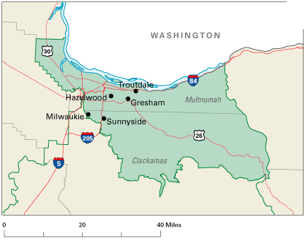
Being based on population makes area irrelevant, and the number of districts in each state are highly variable. Here in Oregon, there are 5 Congressional districts, based on population; the last Census showed a trend toward a 6th District, but we didn't quite make it. The population metric makes for some highly amusing borders. Prior to the reapportionment, this is what the 3rd looked like:


I live very near the dot marked Hazelwood. Fully three quarters of the city of Portland lived in the 3rd up to 2012, just the southwest part of town and part of the northwest being in the 1st District (currently Bonamici, formerly the ill-starred Wu). As of reapportionment last year, this is what the 3rd looks like:

Picture sourced from here.
The 3rd gained the west side of Portland and parts of Clackamas County, but lost the extreme NW panhandle of Multnomah County. Sauvie Island is now part of the 1st. At present, one Congressional district equals approximately 600,000 citizens. It has to be a more-or-less thing, of course; some Procrustean beds just can't be layed in.

The reason I told you all that was to tell you about this. You want to take a a crack at apportionment? Well, the congressional map is said and done and settled, but there is the city council of – appropriately – the Nation's capital, Washington, DC. The District is a unique animal as it has to be; politically independent of any state, the geographical size of a large city, with a population about that of a Congressional district, ruled essentially by the US Congress but with local control devolved to a twelve-member City Council which legislates for the community (the Congress still has the right to stick its nose in where it deems appropriate). Every so often the District has to do the same thing that the nation has to do, so this is kind of a microcosm.

You can take a stab at redistrcting the District, via the DC Redistricting Game, on the web at http://redistricting.greatergreaterwashington.org/, (via the regional blog site Greater Greater Washington). Following the game link above, you are taken to this screen:


This is the territory of the District of Columbia, divided into census tracts. The button on the right allows you to go into the main game if you don't live in the District or you do, but don't want The Man to know where you're spinning your nefarious plans from. Click that button, and you go here:


Now, we're down to business. These are Washington's 8 wards, which you might otherwise think of as Congressional districts in a State, only these have only about 70-80,000 citizens each. On the right there is a color coded list of Wards, populations, and whether the ward is too small, too large, or just right.

Game play from here on out is rather simple. Clicking on each census tract will display a small window giving you the population of that tract and buttons for each ward that you can assign that tract to. Naturally, you can't transfer a tract from deep within a ward to another ward; wards are contiguous, and  outliers such as enclaves or exclaves are not allowed … no gerrymandering now! The population list live-updates as you callously toss populations back and fort, and when everything's acceptable, you'll know right away. Then, you click the done button to share and boast of your Solomanic apportioning wisdom. This is what I came up with:


In order to balance things out, I took a piece of Ward 2 (green) and give it to Ward 1 (Orange); a piece of Ward 6 (pale blue), just west of the Capitol and containing mostly a bit of freeway, to Ward 2, balancing out those two districts. Wards 7 and 8, on the east point there, required a bit more finesse. I
have three pieces of Ward 5 (the dusky pink section along the NE edge (or consult that little map I have right because I'm still sucky at giving suggestive names to colors (when The Wife™ comes along and reads this, she'll proofread me, I'm hoping, because she's awesome at that)) to Ward 7 (buff, at the extreme eastern point). This overpopulated Ward 7, however, giving Ward 8 two small pieces of Ward 7 solved this problem. With those two adjustments, my map was in balance, God was in his Heaven, and civic peace reigns in the District.

Here's a link to my map which will give a better view (the swapped tracts are in a heavy outline:

http://redistricting.greatergreaterwashington.org/#25091-9mi6vq6n.

So, give it a try yourself. No smoke filled rooms now (computers hate that), or Machine politics (at least as far as I can tell, but maybe you can role play with some members of your family you don't like so much and threaten to pull funding on something or other (which DC Home Rule doesn't allow, but this is your game so, hey, play it up.

Remember, the URL is http://redistricting.greatergreaterwashington.org