
 Dig, if you will, this picture.
A while ago, during the early stages of Nerdery, I pontificated at length on how the addresses run out in Washington County. One of the important things to note is that, unlike in Multnomah County, the line that divides North from South (NW from SW, in this case) is a surveyed one; in the main, no road follows it. At least, not largely.
The street name nominated to extend westward from the Multnomah/Washington County frontier was Stark. While we don't have a record of the decision, we can presume why. As a commenter then noticed, West Stark is laid out along the exact same surveyed line that SE Stark St does; it's a logical extension of the street name. Since West Burnside devolves into Barnes Road and which drops away to the south, this wouldn't serve as as ready a division as East and West Burnside do; Stark Street, as surveyed, is only five standard blocks south of where Burnside would have extended, so the difference is minor.
While the NW/SW division is largely invisible to the area resident, noted only by the changes in street prefixes and run of address on numbered avenues, West Stark Street does exist in one or two places (as well as some other street names found in unexpected places extended out from Portland into deep Washington County, but, ah, that's a tale for another post soon to come). There is a piece of Stark that the map claims extends west from Miller Road into the Leahy Road neighborhood near St Vincent's Hospital, but the map calls this "NW Stark St". Another bit, not too much farther west, crosses Barnes Road between the Cedar Hills Blvd signal and the crossing at Cornell and Saltzman. The map calls this "W Stark St", but the sign at the intersection calls it "NW Stark St" (I don't have a photo of this...you'll have to trust me on this one).

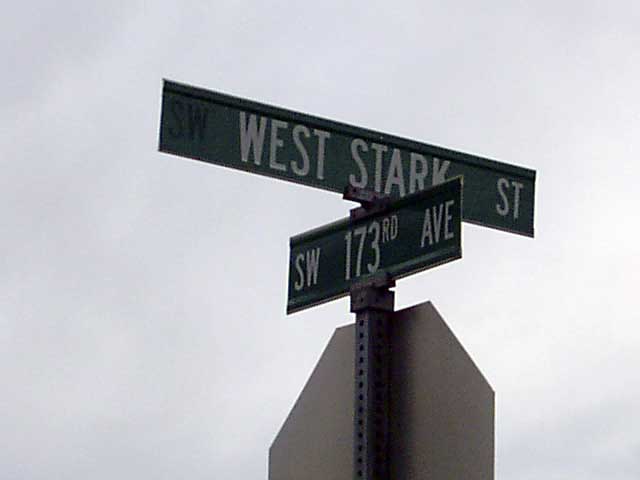
The other part of West Stark Street, and the most remote west section of it, can be found in Washington County, off 173rd Avenue between NW Walker Road and West Baseline Road. It's easy to overshoot but a street directly south of it, SW Nazaneen Drive, allows you to go in the back way via SW 175th Avenue (see the second illustration, which we took whilst stopped in the area where the red-on-white sign says, well...not to stop)
This part of West Stark Street only runs between 173rd Avenue and 175th Avenue (at least, the public part does). It's a pleasant street, in a neighborhood that has a mix of old farmhouses and new developments. The south side of the street shows the new development, including three micro-sized dead end streets called SW Parvenu Pl, SW Pasquirade Pl, and SW Palatial Pl.
You mind the Q's; looks like Washington County public works has the P's covered.
The north side of the street is only paved about 1/3rd of the way over; that side of the street has a charming white wood country-style fence with lovely manicured trees. It is actually quite a charming place.
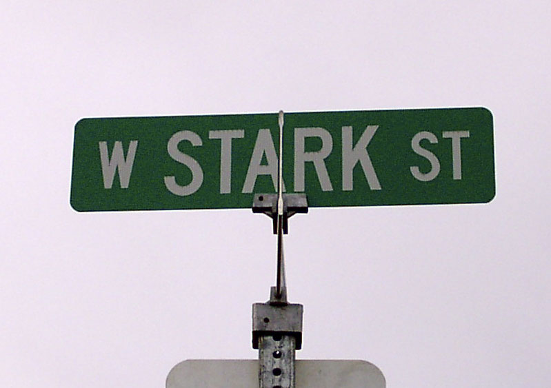
The next photo has something telling in it. See if you can guess what it is before reading on:
Notice the asymmetry of the typography on the sign, and the unusual expansion of the directional: we typically don't spell out the word: that should read "W STARK ST". If one takes a good look at the blank area on the left hand end of the blade, one can just pick out the majuscule letters "SW". This blade once read "SW WEST STARK ST", and the SW was removed.
Credit to The Wife™ for getting the above. I had her doing Sherpa duty whilst I was out taking those pictures, and I was at the wheel of the car, and had her snapping away.
Indeed, there seems to be a bit of revision going on in that area. Baseline Road, long labelled SW Baseline Road to reflect its physical position south of the logical base, is being renamed on the signs to West Baseline Road along its entire length. We saw many signs that used to read SW, with a blank spot where the S should have been, and could trace the outlines of the freejack letter.
We're going back out that way, to visit the Cedar Mill Community Library, tomorrow; I hope to hit the Leahy Road area, and bring back some Stark Street signs from that trip, in order to fully document the thing.
 West Stark Street, in the Elmonica area, facing east (toward 173rd Avenue) from 175th Avenue. The street sign at the right that can just be seen marks the entry to SW Parvenu Pl. In the distance can be seen the western flank of the Tualatin Mountains (the part of the West Hills that contain Forest Park and the transmission towers)
1 comment:
Not only that, Isaac, I also got to Miller Road and West Stark Street. Now that is an interesting area.
It was too late to get any good pictures so we didn't that day; we are planning another trip out there, with the weather improving (?) and the days getting longer, we hope to get some good things.
For the record at this point, the street signs do indeed announce West Stark Street (the Thomas Guide incorrect? Perish the thought, but true! Anyway). The Leahy Road neighborhood is quite charming, I absolutely lurve the charming little store at the 4-way intersection of SW 90th Ave/Leahy/Washington St, and the most interesting things about that neighborhood are two things:
1)The name "Leahy Road" At least according to the signs, is discontinuous. As the traffic turns into SW 90th Avenue, the name dissappears from the signs and does not appear again until the traffic goes east-west again (this is from the viewpoint of one going north and west on Leahy).
2)The traffic signs leave no doubt that you are crossing the boundary from NW to SW. These are interesting to look at, these amazing stacked things.
3)The slope going east from 90th on Stark is amazing. 6% grade is minimum. If you go, bring a sherpa.
We'll be going out again soon to get actual pictures. Also I'm going to be posting on the Willamette Stone soon.
Thanks for asking!
Post a Comment