
3476.
It's not the destination, it's the journey, so they say. Stop and smell the roses is also what they say.
I'd like to find they and give they a swirly or something. Unless they has more constructive things to add, they can keep their lips well buttoned, as far as I'm concerned. They never had to commute to and from a total solar eclipse, did they?
Another thing they said there'd be is a literal car-mageddon. They were wrong, until they were right.
Now, as I've priorly regaled, I am a child of Oregon earth, specifically, that Oregon earth around Silverton. I don't need GPS or really even much of a map if I'm anywhere north of Albany and east of Independence here in the northern Willamette Valley, God's little half-acre, and I'm pretty good at south of that too. And what they were saying was that Monday, August 21st, 2017, was going to be hell-on-wheels, provided those wheels were on an Oregon road in the mid-Willamette Valley.
Still, we went for simplicity in the battle-plan. Head as far south as we could in the time we had. We started out from Out 122nd Way at around 8:15-8:30 AM. From the research I did, I figured if we could get anywhere south of Aurora, or perhaps Mulino if we hit Hwy 213 instead of Hwy 99E, we'd be in line for some worth-it eclipse viewing. As we headed south, I had a tab open to Google Maps traffic as well as TripCheck.org, the ODOT statewide traffic site. It was looking grim then, with notable traffic slowups reporting along 99E between Oregon City and Canby in the gorge stretch of the Willamette River above the Falls, some notable slowing in the area between Canby and Aurora, and at Hubbard. Hwy 213 south of Oregon City was reportedly a long, 2-lane parking lot with an accident, which also affected our Plan C: Beavercreek Road into the backside of Molalla. Hwy 99E looked like the best bet, all things considered, so down the Pacific Highway East we went.
Strange thing, though. By the time we reached Canby and scored some Dutch Bros, it was 9:15 AM and we were a little on-edge, but here's the bizarre thing: there were no real appreciable jams or travails. As a matter of fact, it was pretty clear. In a few minutes, we were almost to Aurora, which is three miles farther down the road:
Our blithe sojourn into the east side of Woodburn was scant minutes away.
So the trip down went. Happy, casual, relaxed. I had heard that the expected throng at the Oregon Coast was a no-show; could it have been similar to with the mid-Willamette Valley? The signs were promising.
That promise was actually broken after the event. It was time to go home and everyone left at the same time. Our vantage point was at about Young Avenue and North Pacific Hwy in Woodburn, as previously mentioned. After waiting a few minutes to let the rush of the event abate we too embarked on the northward trek home. We hit the old bumper-to-bumper on before we were even half-a-mile down the road in Woodburn; it was locked and loaded from just north of the Hwy 211/214 junction, just south of the MacLaren Youth Correctional Home, to Hubbard. This two-mile distance took more than 45 minutes to cover.
There was not only time to stop and smell the roses, there was time to smell the exhaust from other cars, the seething impatience of other drivers, the interiors of other cars (but be polite, always ask first!), to lick the roadsigns and electric fences, to settle down, marry, and start a second family. People would get to Hubbard, park the car, find an apartment and just live there because, hell, they weren't going anywhere anyway. It took so long to get from Woodburn to Hubbard that when we saw this sign, I got out, signed up for lessons, completed them, and by the time the car passed the other end of the property I had three offers for concert bookings.
North of the Hwy 551 turnoff the grinder loosened up a bit but it choked back up by the time we got to the east end of Canby. 99E was stop and go from the west end of Canby to just past New Era, then broke open again, choked up a little just as we got to the Oregon City city limit at Canemah, then was stop-and-go but a little less aggravating through Oregon City's adorable-yet-claustrophobic downtown. We stopped at the Shell station by the Arch Bridge for a breather.
The distance from the spot we were, in Woodburn, to the spot we found ourselves in, in Oregon City, is close enough to eighteen miles. We had made that trip in about three hours. Woodburn to Oregon City - at an average of six miles per hour.
If a total solar eclipse is a once-in-a-lifetime event, then so is that traffic. And if I ever get my hands on they, they's got some hard explaining to do.
And so it goes.
I'd like to find they and give they a swirly or something. Unless they has more constructive things to add, they can keep their lips well buttoned, as far as I'm concerned. They never had to commute to and from a total solar eclipse, did they?
Another thing they said there'd be is a literal car-mageddon. They were wrong, until they were right.
 |
| From the 1971 Official Oregon State Map, published by ODOT |
Still, we went for simplicity in the battle-plan. Head as far south as we could in the time we had. We started out from Out 122nd Way at around 8:15-8:30 AM. From the research I did, I figured if we could get anywhere south of Aurora, or perhaps Mulino if we hit Hwy 213 instead of Hwy 99E, we'd be in line for some worth-it eclipse viewing. As we headed south, I had a tab open to Google Maps traffic as well as TripCheck.org, the ODOT statewide traffic site. It was looking grim then, with notable traffic slowups reporting along 99E between Oregon City and Canby in the gorge stretch of the Willamette River above the Falls, some notable slowing in the area between Canby and Aurora, and at Hubbard. Hwy 213 south of Oregon City was reportedly a long, 2-lane parking lot with an accident, which also affected our Plan C: Beavercreek Road into the backside of Molalla. Hwy 99E looked like the best bet, all things considered, so down the Pacific Highway East we went.
Strange thing, though. By the time we reached Canby and scored some Dutch Bros, it was 9:15 AM and we were a little on-edge, but here's the bizarre thing: there were no real appreciable jams or travails. As a matter of fact, it was pretty clear. In a few minutes, we were almost to Aurora, which is three miles farther down the road:
 |
| Highway 99E at Barlow Road. No poblano. |
 |
| About 3/4ths of a mile beyond the last photo. Just over this hill is Aurora. Amusingly, the yellow diamond sign to the right there reads CONGESTION. |
So the trip down went. Happy, casual, relaxed. I had heard that the expected throng at the Oregon Coast was a no-show; could it have been similar to with the mid-Willamette Valley? The signs were promising.
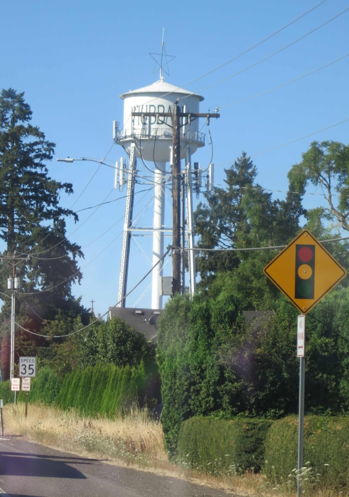 |
| It was a roadside sight on the way down, now, we call it home |
There was not only time to stop and smell the roses, there was time to smell the exhaust from other cars, the seething impatience of other drivers, the interiors of other cars (but be polite, always ask first!), to lick the roadsigns and electric fences, to settle down, marry, and start a second family. People would get to Hubbard, park the car, find an apartment and just live there because, hell, they weren't going anywhere anyway. It took so long to get from Woodburn to Hubbard that when we saw this sign, I got out, signed up for lessons, completed them, and by the time the car passed the other end of the property I had three offers for concert bookings.
 |
| It took us so long to get from Woodburn to Hubbard that I learned the piano her. I open at the Keller in December; watch this space |
North of the Hwy 551 turnoff the grinder loosened up a bit but it choked back up by the time we got to the east end of Canby. 99E was stop and go from the west end of Canby to just past New Era, then broke open again, choked up a little just as we got to the Oregon City city limit at Canemah, then was stop-and-go but a little less aggravating through Oregon City's adorable-yet-claustrophobic downtown. We stopped at the Shell station by the Arch Bridge for a breather.
The distance from the spot we were, in Woodburn, to the spot we found ourselves in, in Oregon City, is close enough to eighteen miles. We had made that trip in about three hours. Woodburn to Oregon City - at an average of six miles per hour.
If a total solar eclipse is a once-in-a-lifetime event, then so is that traffic. And if I ever get my hands on they, they's got some hard explaining to do.
And so it goes.
2 comments:
Anyone who visited over the weekend was sent home via The Magic Maze of Side Routes That Only I Know About and arrived at the desired time. The tourists were too freaked to plant a toe off of the freeways.
Y'all play nice, now!
Heh. Or the main roads, either, apparently!
Post a Comment