Showing posts with label Salem. Show all posts

19 June 2024

The Mural at the Back of the Elsinore

4152I was taking a stroll through my photo archives (have I really been taking amateur pictures for that long?) and I found this photo I took in Salem back in 2017 while me and spouse were on a visit there:


This is the back (east) side of the building containing Salem's Elsinore Theater. The view is from the corner of Church and Ferry Streets SE, on the edge of downtown Salem; to get this viewpoint, go west of Bellevue St SE from 12th St SE, then follow the curves through Pringle Parkway until you get to the light at Church Street. Look to the right. The facade of the Elisnore faces High St SE, one block west of here.

If you've ever seen the front of the Elsinore or been inside you know why it's Salem's palace of fine arts and live performance. Back in the day, though, it was a movie house, and kind of worked as a pair with its counterpart on State Street, around the corner, the Capitol Theater.

The Capitol Theater closed decades back and was eventually razed.

The Elsinore, however was where I saw Star Wars back in '77, Star Trek: The Motion Picture in '78, and a number of popular and Disney films during my teen years. As it moved into the 80s it got reinvented as a live performance space and stands as the grand dame of the Salem arts scene. But even before this, this mural happened.

The icons are from the golden age of motion pictures. And it went up sometime in the late 70s; I remember viewing it quite often, as I lived in east Salem and used Cherriots to bus to school at Sprague (Salem Public Schools let you attend the high school of your preference at the time, and I grew to know the State and Fairview and South Commercial routes like they were a personal vehicle) and when I was inbound on the State and Fairview route, it usually went through the Ferry and Church intersection.

So this mural has been up for more than 50 years, and it still looks lovingly tended to, which is one of the neatest things I can think of right now.

01 April 2024

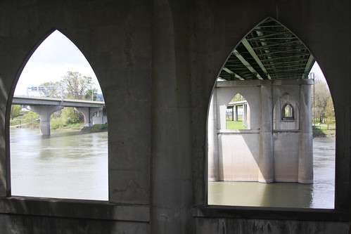
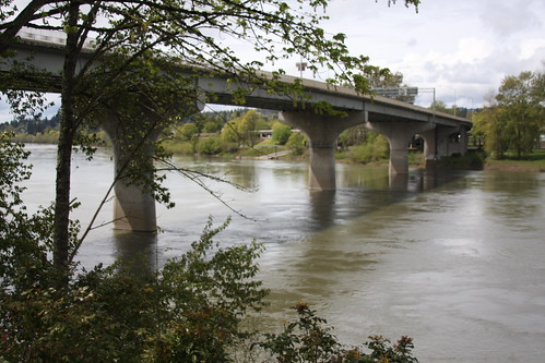
The Center Street Bridge, Salem

4114

Salem's Bridges, like Salem itself, are contradictory.

They're essential, but unremarkable. They're crucial, but you don't think about 'em much. There's nothing preposessing about them, but you'd miss 'em if they were gone.

Salem, depending on the year, is either the Oregon's Second City or Oregon's Third City: after Eugene holding a slim lead for the greater part of my life, they've been one or two thousand apart and swap the position once every couple of years. Right now, I think Salem's number two. And for a city as big as it is now, with only two bridges linking the two halves ... well, that's just kind of absurd.

If you want to go from the eastern half of Salem to the western half, you have to go through downtown. And if you're going to the west side, you're just as likely to be bypassing west Salem as you are likely to be destined there. It comes from the two sides' shared history, of course: founded in 1913, West Salem, Oregon was city of its own until it merged with Salem to form the kernel of the present-day town.

They needed infrastructure work and didn't have the money, is the story I always heard.

So, West Salem, before it was merely west Salem, was a suburban destination. 


And to this day, there's only one way into West Salem, and one way out. The bridge pictured is the way out. West of here, State Hwy 22 forms a very brief riverfront expressway bypassing the West Salem business district, Edgewater Street NW, before dividing, in a manner shared by Albany and Corvallis, into two main city center streets. This bridge feeds Center Street NE. 

It's a muscular bridge, as is its older sister, the Marion Street Bridge, immedately north. Has to be: it's not only the only way across the river for miles in either direction, but it's the main highway west out of Salem in toto. And, unlike our Portland bridges, it just does its job without calling attention to itself.

Pretty much like Salem itself. State capital, political power center of the state, but outside of the Capitol Mall ... it's just this Oregon town. 

31 March 2024

Historic Houses on the Salem Waterfront

4113

Waterfront Salem is a vastly different place from what it was when I was growing up. In the mid-1970s Front Street served an what amounted to an industrial area and was laced with disused railroad tracks. 

I wasn't even aware there was a Water Street, which is the closest street Salem has to the river, until the 80s. And even then it wasn't clear how one would get down there.

What a difference forty years makes. Not only is it a simple thing to get down to what is now a lush and inviting public space, but there's lovely interesting things to see there. Following Union Street NE one block west of Front, you bear left at the old steel bridge that used to carry a rail line across the river and is now a very nice pedestrian bridge connecting the east bank riverfront to Wallace Marine Park in west Salem. 

Between the Marion and Center Street bridges, along Water Street, is a big Victorian house which today is devoted to housing the Gilbert House Childrens' Museum. Along side of it is two other historic houses which is part of the Childrens' Museum complex.


The addresses are 450 Water St NE (on the left) and 440 Water St NE (on the right). I did bump the color up on this photo, because being adjacent to the main Gilbert House itself, I had storybook illustrations playing about in my head.

This angle, looking back the way we came, shows the Gilbert House itself, green amongst the tree.


Cheerful, charming, historic Salem. 

Oh, and it bears mentioning that the Gilbert who the Gilbert House represents is A.C. Gilbert, the man who, through his efforts, gave the world one of the landmark toys of the 20th Century ... the Erector Set. Yeah. Like the guy who gave the world the View Master, A.C. Gilbert, too, was an Oregonian.

30 March 2024

Salem, We Need To Talk About State Street

4111

Salem, you need to get a grip. You got lots of problems. You might run out of money. That's bad. You might close your public library. That's appalling.

But this ...

Explain, I will.

Now, Salem has directional addresses as anyone who's ever heard me drone on about city maps and street layouts and address systems will, after all this, have by now known. And especially if you live there. And it works like this: If you're on the east side of the Willamette River but north of State St, you're NE. And if you're on the east side of the River and south of State St, you're SE. But if you're on State Street, you're neither NE or SE; it's the dividing line. Also, there's no State Street on the west side of the river, so there's no State St W, therefore, no State St E. 

It's just State St. It always was State St. 

Now, just west of Cordon Road NE, which is where town ends (both the unincorporated fringe and the city limits, where they come out that far) and on the north side of State, for years, there was a field, going up to a rail siding that ran parallel to State, and a locally-famous mushroom production facility. I lived on Abiqua Ct SE, just off State via 47th Ave SE, during some formative years during my teens, and we all knew about it

You know what mushrooms grow in. The smell got around.

Well, in the decades since, the mushroom plant has gone, and the rail line with it, and at long last the area along the west side of Cordon Road NE going north from State Street in the direction of Auburn Road is finally being filled in with a housing tract. New streets going in, new houses going up, little old Snailem inching its population ever closer to 200,000. Some of the street blades have already gone up. and here's one sharked from Google Street View:


State St NE, the sign says. And this is wrong, Salem, and you know it.

Why is that a problem, you might ask? Wouldn't the north side of State Street be NE? Well, like I said before, State Street is neither NE nor SE, and it's not E because there's no W half. Besides, most blades along State St just look like this:


This is 47th Ave SE and State, just a few blocks west of that (this corner is in unincorporated Marion County, which has shifted to a street blade format nearly identical to that used within Salem city limits over the years). Just State St. Just like it always has been.

Like eliminating the leading-zero district here in Portland and making it S, labelling State St as NE or SE depending on which side of the street you're on fixes a problem that doesn't really exist and erases a charming local address custom. 

Now, Salem, I know you're short of money and all, so all you have to to is stick a piece of green over that NE there. 

But however you do it, get a grip here.

I say this because I care.

The author is available as a highly-opinionated consultant on designing street naming and address systems due to his obsession of it over the course of more than four decades. Contact for rates.

17 November 2021

Sur La Mer (our 31st Anniversary) Part 50: The End of the Road

4037

The corner of Winter and Gaines Streets in north Salem ... That's the trip, my friends, those of you who have followed my string of babble and photos on this meagrely-read blog, I'm grateful to you.

For me, and for all I know, for my wife as well, a trip to the Coast and returning to the Valley have a certain bittersweet despair to it, and for me, it always has. You're back inland, it was cool and bracing and it's now warm and a little stultifying; such is the contempt that familiarity brings, and the northern half of the Willamette Valley is the literal ground from which I sprung, some patches of that dirt I literally know as well as parts of my very own body.

So, here it is: a picture of a modern street sign on a corner in sleepy residential North Salem, just a few blocks away from the house my wife lived in when I met her (an area she can still find her way about blindfolded, I'm sure)

It's still a damn fine place to spend ones' life, this part we know today as a part of northwestern Oregon, but compared to the Oregon Coast, everything seems a little lacklustre, at least for a while.

And so it goes.


16 November 2021

Sur La Mer (our 31st Anniversary) part 49: Another View Down 12th Street Hill

4036

This is a picture I've taken before, but I can't resist taking it again when I've the chance.

Coming north on 12th St SE, heading from the South Salem hill toward the city center, as one passes Madrona St SE one will notice the hill. A long, straight hill that connects 12th Street on the hill to its lower-elevation leg. It gives a great visual angle.

And, also, one pleasant trick of Salem geography is that a few streets look like they lead right up to the Capitol but don't actually go straight there. Center St NE is one. And 12th St SE, from this point, is another.


This angle also shows off one of Salem's most seductive aspects: so covered in trees that one has to get a pretty high vantage point in much of the town to actually perceive a town. Salem is all about trees, and that's one of the most beguiling things about it, but unlike Oregon's other big cities, it doesn't like to brag. It ... and its populace ... just enjoy what they have there. 

Sur La Mer (our 31st Anniversary) Part 48: One Of The Most Interesting Street Blades In Salem

4035

As proven elsewhere in this prolix chronicle, a road trip to me isn't complete without bagging a few street blades. And we were just happening to cruise down South Commercial into the hilly, forested demesne known as South Salem where two important local roads come together.

One, of course, would be Commercial St, SE or, in the local parlance, simply South Commercial. The other is the end of what seems to be 12th St SE, but not technically so. If one follows 12th south from the city center one will note that near that south end the street bends southwesterly to intersect with Commercial. While this directs all 12th Street traffic to a merge with Commercial, this street has actually changed its name. 12th St SE's name is extended straight south into the neighborhood immedately east of that; the diagonal road's name, reflecting its function in connecting 12th to Commercial via the path of least resistance is 12th Street Cut-off, SE. And the signs reflect this.

A further cut-off ramp reaching a little north on Commercial looks like this, omitting the directional SE:


Meanwhile, across the street, a severe angle with the intersection of Ibsen St SE put both streets on the same placard, as it were:


This sign is more in keeping with the general design grammar and logic of the average Salem street blade, while giving the eye an interesting thing to look at by enlarging the ST abbreviation to the visual precedence of the rest of the street name. 

However one looks at it, the blade for this Salem street has to do a lot of work, more than most, and makes the display of one of the more interesting street names in any town I've known just that much more memorable. 

12 November 2021

Sur La Mer (our 31st Anniversary) Part 47: At Salem

4034

After all this rambling and ambling, we pass through the Salem City Center.

You can't help it, really. There's only one way to go if you don't know the area, and that's it.

Salem's a funny burg in this way. Currently, the population within the limits of Salem is about 175,000. It lies on both sides of the Willamette River, as do Portland and Eugene, but unlike Portland and Eugene (and especially Portland), there are only two bridges connecting east and west banks, and when you view the Marion and Center Street Bridges as two sides of one highway, there's only one real road over it. 

And if you don't hit the river crossing there, you have two choices; the bridge at Independence or the one at Newberg, which get you to countryside locations that are 10-20 miles distance. 

The inbound side of Hwy 22, which ends its westbound approach as a riverfront expressway bypass separating downtown West Salem from the river, becomes Center Street Bridge and comes to ground on the east side in downtown at Commercial St NE. As one crosses that bridge, this is view from the car window:


It's quite a beautiful riverfront these days, and a world's difference from when I was a teenager and a early twentysomething here. What amounts to high-rise buildings in downtown Salem can be seen here, too; one can quickly surmise that my old hometown is a pretty modest place. Salem always has been fairly modest about itself. Makes a rather lovely place of it, I can see now (in all honesty, I did not always see this. Perspective makes you consider things differently)

If one scans in from the left side, the first tall building one sees is the Capitol Tower. This is an 11-story high-rise at the corner of State Street and Liberty Street, and is about 151 feet tall as far as the building structure itself goes. This is the tallest office building in Salem, and the third-tallest structure in town after the First United Methodist Church (whose spire tops out at 188 feet) and the State Capitol (the coif of the Oregon Pioneer being 176 feet above street level). There is, alas, no observation deck (in that way, Portland and Salem have a common thing). 

The only other tall building you can see there is a 7-floor condo silo down on Front Street. That was a bit of surprise for me ... there's apartment towers in downtown Salem now. My little home town is really starting to grow up, I guess.

Here's another experiential landmark:


This is the Equitable Center at Center and High Streets. It tops out at a modest 7 floors and was built back in the 1970s and, like certain other tall buildings I can think of, is named for a financial institution that no longer exists as such (or at all) but, palimpsest-like, the name lingers on. Quite a stylish example if the day, I always thought (as I came home from school in the evenings on the Cherriots bus). 

And, no matter where you are in central Salem, you're never far away from this modern monument:


Why didn't I ask The Girl to pull over on Court Street to snap some update pictures? Well, you know that point in your trip where the pull of home is very strong? We were there. 45 minutes down Interstate 5 and we'd be back. 

We did a little loop around town (I have a few more pictures to share) and then headed back. And there must always be a reason to come back to town because few opportunities seem to present themselves these days, and reasons for follies such as these must always be at the ready.

Sur La Mer (our 31st Anniversary) Part 46: Hwy 22 West Of Salem

4033

This is kind of a continuation of the feeling I started in the last post, but with a different angle of incidence. How things were to how they are.

After passing the junction of Hwy 22, Hwy 223, and Hwy 99W that has developed over the last 40 years to enable you to bypass the intersection burg of Rickreall so well that you don't have to go through it even if you are trying to get to Dallas from Salem, the highway bents from NW-SE to dead-on E-W and begins the first part of the final approach into Salem from the west across the flat farmlands that dominate the area between there and the edge of the Eola Hills that define West Salem. 

Just like many things I comment on in my roadworthy experience, this was not so remarkably as it is. That is actually a banal observation overworded because I wanted to, but no less true: the interesting thing about Hwy 22 coming into Salem from the west is how it's evolved. The only similar highway I can imagine in form and function is Portland's own Sunset Highway, but that was laid down at one more-or-less fell swoop. It's a full-on freeway. Hwy 22 started out as a local road and evolved that way, and it hasn't finished its evolution. 

Dig, if you will, this picture:


This is along part of that length I mentioned before. Straight on like an arrow from Rickreall to the Hwy 51 junction just west of Eola Bend. Less than a mile to the right as this angle has it, there's a local road called Rickreall Road that winds close to the namesake creek, intersecting 99W just south of 22 at the namesake community. This road used to by Hwy 22, and was bypassed by the road in the picture above, which went in around 1970, give or take a couple of years. 

At the time and for many years after the verges each side of the road were treeless, giving unobstructed views of the fields and farms on either side and the rail line it passed over, but at some time during the intervening 30-plus years succeeding the 1980s someone got the idea to plant these trees, and I did rather enjoy the feeling of going down a tree corridor as we passed through this part of Polk County approaching the metropole. 

The next picture is taken from the car window at a place I like to call Eola Bend: the historic townsite of Eola still exists here and this amounts to the business district. It's the extreme western edge of the incorporated area of Salem, and it's where Hwy 22 finally comes up against the Willamette.


The name on the building reads Eola Inn, because that's what it was as a business and what it is as a landmark. It's been a roadhouse, middle-to-upperbrow supper club, and a outlier to the Rock'n'Rogers chain of un-remarkable painfully-50s burger dives. 

It now appears to be the central building of an awkwardly-arranged used car lot. Never saw that one coming. 

21 September 2017

[OR_liff] Greetings From Downtown Salem, 1958

3508.
I stumbled on this on a page from the Worldwide Elevation Map Finder page for Salem, after being turned on to the image by another friend I have on Facebook, which means this is probably from someone's Flickr but I was unable to determine whose. So, if youse whose stumble by here and find it and let me know, I'll link credit for the scan or take it down as you prefer, but I really wanted to share it.

This is downtown Salem, looking east on State Street from its intersection with Commercial, and I'm guessing that, given the angle on the shot, the photographer is probably on the southwest corner (in the shadow of the 11-story building today called the Capital Center). The vintage of the cars suggest this was taken in around 1958.


What really made my heart sing with remembrance was that curbing there, in the very street, enforcing a left-hand curb-lane turn from westbound State to southbound Commercial. I've never been in another city, not even in Oregon that did that. Just Salem. It's was Salem's way of saying You're gonna make a curb-lane turn, pal, or how're ya fixed for a spare tire right now? Those concrete snakes lay on the curb through about the mid-80s, I think.

Much nostalgia for those of you who remember those old, old Salem commercial names. 

05 September 2017

[maps] Salem, Oregon, Within Her 1956 Boundaries

3485.
I'm leaving this here as a pretty and a bauble and a sort of a bookmark, and also drilling down into some more interesting detail of the 1956 Oregon Official State Map.

The back of the map has, as intimated, a number of insets giving detail of larger Oregon towns. One of the more important would be, of course, the state capital - then, as now, doughty Salem. The 1950 Census, as recounted in the city list in the index plus, one would assume, estimates for the six years thereunto, give a population for Salem as 43,140 (today's population is around 165,000, headed for 170,000, which is a change from my own childhood my mind's still having trouble encompassing). According to the state map, Salem laid out about thusly:


I could look at that hand-done lettering all day, it's so charming.

Okay, anyone familiar with the current geography of Salem will probably gasp a little at how small she was. Commercial Street, the main drag south (labelled BUSINESS 99) ends, in this panel, right at the point where modern-day Liberty Road forks off, or just south, where Vista Avenue crosses. By the time the late 60s were around, barely a decade later, the city had annexed Commercial all the way out to where it merged with what was then being called I-5 (and what was being called BY-PASS 99 in this map). The city also breached the bypass freeway on the right by the mid-60s. Another obvious difference is that what we today call Market Street NE is, on this map, outside the modest city limits, anyway, "Garden Road". Swegleing to the freeway would have to wait a few years.

I'm going to try to combine information from this and another map to tell a third story. It won't be a complicated one, but it'll be a story that I enjoy being told and telling again. Check back here for that.

29 April 2017

[liff] Sightlines Of Salem, Oregon

3470.
Yesterday we were in Salem for a momentous life event. More on that anon.

One of the interesting things about Salem is that the layout of the town gives these wonderful sight lines to the Capitol building which is the city's focal point. The really interesting thing is that the geography makes it look like at least a couple of major streets in town terminate at the Capitol while the geography actually deflects them before they get there.

This is the view from Center Street westbound in the neighborhood between 17th St NE and the Oregon State Hospital area:


And the next two are from a POV near the top of the hill on 12th St SE, just north of Madrona Avenue.


That's 12th St receding into the distance. It's a great, pretty view, really. Salem should really sell this sort of thing. It's the kind of thing that goes on posters. Or should.


This is from slightly farther down the hill, and would have been better if I could have held the camera steadier. The angle on the street is much more enticing. 

Salem is just as photogenic as Portland is, but it's a lit shier. You have to go looking for it. 

18 March 2017

[logo] A New Logo And Type Look for Salem's Transit

3466.
I follow the news with the mass transit agency serving the greater Salem area, Cherriots. Mostly it's in the 'how much of it they got' department; having grown up in the Salem area, it was my ride around town for a great deal of my high school experience. It connected me with high-school and a good many things around my erstwhile and doughty home town, and it seemed to be more vulnerable to the vicissitudes of funding than the other two major systems I was then familiar with, the Lane Transit District and TriMet, whose service I always envied because in Eugene and Portland the buses ran later and they had transit on Sundays. I survived hour-long waits on Saturdays, buses that quit running around 7 PM, and at least one major service cutback (during the late 70s the service, which was then a function of the City of Salem, was curtailed back to within the city limits only, where formerly it had gone just beyond. We Salem fringers living along Lancaster Driver and in the Four Corners area missed it mightily until the Hamman jitneys came along, but that's all a story for another time).

Then Salem-Keizer Transit established its district, service returned to the Salem urban fringe, and I left town to see the greater world, in more or less that order. Latterly, Cherriots has had to cut Saturday service because revenue but has been extremely clever in using what they had to best effect, constantly rethinking service and how to deliver it. It's been an impressive story so far, and if Salem-Keizer Transit ever gets the funding I think they deserve, with the agency's creativity, Salem could someday have world-class mass transit for a city its size.

Since the 80s, the agency has had an informally-styled script logo with a visual pun on the name, which looked like this:


The o being styled into an abstract cherry and the name itself are all puns on a somewhat forgotten-by-now nickname for the capital, the Cherry City, Salem's cherry orchards once having been a great draw to the area in the spring. The Oregon Statesman and, for a short time, its successor, the Statesman-Journal, published suggested driving tour routes when those trees were in bloom.

Slowly infiltrating the agency's public presence and by now its printed and PDF collateral, has been this new look:


Featuring a hip, bold sans-serif font with some weight to it (which reminds me of the font used by C-Tran in Vancouver), the logo expresses a very mission-driven agency which is visualized by the sweeping curves both concentric on and emanating from the enlarged initial capital, which quite obviously evoke a high-speed highway.

The brand has been simplified; gone is the tagline Salem-Keizer Transit, it's simply CHERRIOTS now, and the simplicity combined with the sturdy, bold type gives a real visual strength and presence. The sweeping abstract highway provides dynamic tension in the way it emerges from above the C and in the way it ends on a cut-off angle. Gone also is the bright dash of red filling an o stylized into a cherry, a feature of the system's logo since its inception.

The brand is also going region-wide. Up until now, the division of Cherriots that provided rural transit service to Marion and Polk counties has been known as CARTS, an initialism that stood for Chemeketa Area Regional Transit System, whose logo wasn't much to speak of. CARTS is being rebranded as Cherriots Regional and being brought under the brand's banner.

The new graphic look hasn't emerged on the website but it appears to be on all digital and PDF collateral, including service advisory graphics as well as schedules, and presumably printed matter as well.


Bottom line here for me is that this is a fairly cool, modern look for a transit agency that hasn't changed much graphically in long time and stands comfortably alongside the other major transit agencies in the Willamette Valley; it's a refined, poised, and serious presence. As I read the current news about Cherriots, I get the impression that they are, at least in spirit, trying to lay the foundation for a fully-grown up transit system to serve Salem, maybe one that will at last have buses on Sunday. The logo fits an agency who is trying to level itself up into the next-generation system for Oregon's state capital city.

Those who liked the splash of red in a stylize cherry will have to make their own peace with that.

07 August 2015

[liff] Salem's Courthouse Square Transit Station, Feb 2008

3210.
I was born, as I've said before, in Silverton, and some assembly was required there; in about 1976, my family moved to Salem, where a lot of the preliminary finishing happened.

The years in Salem were mostly happy, at least as far as those of a kid of no obvious talents except hangin' on could be. Found my first passions, my first group of permanent friends, did some healing at the same time some other wounds were being inflicted. Life is such a mixed bag, even tho' it beats the alternative.

I spent a great deal of time with my first real freedom other than my bicycle; Cherriots. I've mentioned Salem's bus system before, in other contexts; in this one, it was my car. They let you attend any high school in Salem you could haul yourself to, just as long as you showed up; my endless quest to move off Square One led me to Sprague High, and Sprague High is where I spent my secondary school career. I don't regret it.

Throughout my mid-late teenagehood in Salem, though, Cherriots was the way to go, as far as it went. Service was only hourly, coverage was pitiful when the money wasn't there to run it, and Salem, as long as I've been alive, has never had Sunday service (now, it has even less, but they appear to be working on that).  Also, the form of the facilities has changed over time. As long as anyone's known, the central transfer point for all radiating routes has been the corner of Court and High Streets. Before the early 80s, the buses lined up along the south side of Court Street between High and Liberty and the west side of High between State and Court. Following this, the transit center moved to an island comprising the entire block of High Street between Court and State, now in front of the Marion County Courthouse; a one-block (Salem's downtown blocks are verrrry long, to a Portlander) transit mall of sorts which occupied the eastern 2 lanes of High. North and west-bound buses departed from the east side of the island; south and east from the west.

They called that Cherriot Station.

In 2000, the downtown Salem transit station finally grew up. The buildings on the north side of Court between High and Church were pulled down … including the venerable old Senator Hotel … the block was cleared, and, bingo, there was Courthouse Square and the downtown Salem 'transit mall' … the south half of the block surrounded by Chemeketa, High, Court, and Church Streets was a new, brick-covered, five-story building, and the north half was now a four-lane transit center with spacious walkways, angled turnouts. Very polished, and very nice. Well, it was until 2010, when it was discovered that the construction wasn't as sound as it should have been, and it was declared a potentially dangerous place to be.

Now, in 2015, after a flurry of legal action and a monumental and commendable repair program, as of 2014, Courthouse Square is now safe and sound and in regular use as Salem's transit hub again. Good on them for getting the job done, and more power to them.

Cherriots is in what they'd call a rebuilding year; the agency is getting set to implement a major route realignment and increase service during the days it does run (Currently Monday through Friday only), and they're beginning to plow the PR field to cultivate the idea that Salem's voters should not only re-inaugurate Saturday service (cut a few years back because the voters said 'no') but also, finally, expand to Sunday service. I hope they make it happen; Salem isn't as easy to get across on ones own as it should be. So I sincerely wish them luck here.

But I digress a bit. Let's set the time machine back to February, 2008, more than five years ago. This is long enough ago that not only did Cherriots have different routes, evolved from the original routes of the 70s that I knew so well, they still have the classic names. Routes like South Commercial, State and Fairview, 12th and Sunnyside, and Lansing and Claxtar. They still have a certain ring, even today.

The following were taken in February, 2008, with a ViviCam 3705, the old plastic fantastic.

This green banner welcomes you with a promise of service in Fall, Winter, Spring and Summer.


The simplicity … and somewhat aggravating lack … of service at the time is aptly represented by this display on an informational kiosk. These are all departure times, on all routes, for all days of operation. Notice the red times? Those are the runs that only happened on Saturday. All times in black departed all five weekdays, Monday through Friday, but not on Saturday.

There was no Service.


A closeup of the schedule for Route 1 - Commercial Street, a major trunk route serving the commercial corridor extending south from downtown along Commerical St SE, with about 30 departures over the service day. Most AM runs didn't operate on Saturdays.


This photo is one of a diagram of the bus bays and where the routes dock. Very nice and ordered. I noted at the time that the font used in the bus symbols was pretty much the same as the old route-number-name font that Tri Met used at the time. I liked it. It gave it a big-city feel. As did the whole production.


This next diagram is the route network in effect as of February 2008. It's notable that Cherriots had grown from around 14 routes when I was in high school to nearly 25 routes by then. Interesting topology there, I always thought … the Salem street network is visually interesting, and the way the transit route net minimized it is a pattern I still find interesting today.


… all this on one of two informational kiosks, one at each end of the transit mall area, such as:


The 16-Four Corners bus held special nostalgia for me. When I moved into Salem from Silverton, it was the Four Corners neighborhood that I found myself in.


… and here is a long shot of the then 9-Kaiser Central bus. The color scheme of the Cherriots is simple and practical … hardworking yet unique in its way.


There were to be more pictures, but a sudden end to my photo safari, which was just to document this place for my own nostalgia and satisfaction and maybe artistic inspiration, but …

Well, it was interrupted. More on that at a later time, though.

06 July 2015

[photo] Gaiety Hill Alley, Salem, Oregon, February 2008

3203.
Just a moment in time that caught my eye:


This was taken in February 2008, and is of an alley in the Gaiety Hill section of Salem. That's the hill that the Civic Center is built onto the north side of, overlooking downtown from the south. Commerical, Liberty, High, and Church streets run over it; east to west you have Oak Street and Leslie Street.

When I was growing up in Salem, most of us didn't know that knoll even had a name, really. But it's a nice area (doubtless with mortgages to match). And this alley was always the kind of residential back alley that I've loved. The kind of urban interstice that radiates ineffable hominess and comfort.

Most likely this is an alley running between High and Church, just north of Mission … if memory serves me correctly.

That moisture on the ground? That's what we used to have around here called rain. Oregon used to be famous for having too much of it. We sure solved that problem though.

11 April 2015

[Address_Nerd] In Passing: Two Interesting Salem Street Names

3175.
While I've not called Salem home for many a year (and at this point feel myself more of a Portlander than I've ever been of anywhere else), I'd be lying to myself if I said I didn't still feel somewhat at home there.

You can take the boy out of Marion County (or he can), but you really can't take Marion County out of the boy. The strawberry patch has set its stamp upon me, aye.

Since I don't get back to Salem as often as I ought, Google Street View is my friend betimes. And since the street level photography has gotten so damn good over the last few years, I indulge my urge to see what the street names and blades look like and how they have changed over time. There are two interesting bits of nomenclature that have stuck with me. I delved and found, and I'd like to share them now.

1. The Cutoff at the end of 12th Street.

12th Street, SE, is a major access backbone to the area of southeast Salem east of Commerical Street but west of the Salem Airport. For over 2 and a half miles south of State Street it distributes traffic and commerce to those inner south-east side neighborhood areas, climbing the hill south of Vista Avenue, and then swerving southwestward to merge with Commercial Street at about the 3800 block, just north of where Sunnyside Road SE peels off.

What is easily missed, though, is that the road stops being 12th Street SE at that point. There is a 12th Street SE south of this point … but it lines up with the main stem of 12th and goes from Duffield Heights St SE south to Hilfiker Lane SE, in the small neighborhood just east of Commerical, south of the 12th St light. That diagonal section connecting 12th at Oakhill Avenue SE to the big traffic signal plenum at Commerical Street is actually known as …


12th STREET CUT-OFF SE. A real mouthful of a name. But it lends itself to, perhaps, the most intriguing looking street blades Salem can boast. The above blade blends the signage for Ibsen St SE and 12th Street Cut-off due to the interesting angle of the intersection, and the extension across the main road that allows southbound 12th Street traffic to access Commercial Street northbound … a dendritic ramp affair that also connects to Promotory Place SE.

Another interesting thing is that the signage is not consistent. There are two other cross streets to 12th Street Cut-off, Doris Ave SE and Oakhill Ave SE, and both the signs shift the "ST" generic to above the block index, leaving the "CUT OFF" kind of dangling there.


The street name is most prosaic, as the cut-off does provide a shortcut to Commercial Street. Giving it a variant name also prevents a duplicated street name, as the southern third of 12th Street Cut-Off is somewhat parallel to the southernmost extensions of 12th Street SE, just a few blocks to the east.

2. The One And Only Link You Need.

The other interesting blade happens in West Salem. I lived near this place for a very short time. There is a street that links Kingwood Dr NW and the place where Hillcrest Dr NW and Riverview Dr NW come together. This is a very short street, on the order of only about 180 feet in length, and in honor of its functional position of being very near three streets but not actually being part of any of them, it's simply (and also prosaically) called …


THE LINK ST NW

The "ST" generic seems to be a later addition; when I lived in that neighborhood, maps and the street sign simply called it The Link, NW. Latterly, I've noticed, post offices and city planners abhor a vacuum in the generic spot (Witness here in Portland where SE Reedway (a per se street name sans generic) is increasingly posted as SE Reedway St, a misnomer. So, the awkwardish The Link Street NW it is for them. I'll always see it a little different.

At least the word THE has been retained, giving a memorable presentation. 

21 May 2012

[transit] Good News for West Salem Bus Riders … More Routes

2827.Have been following the news in transit down in Snailem ever since the peoples decided not to vote the last transit levy, which, in Oregon's third larges city, and the State Capitol, shaved the Cherriots down to a five-day-a-week system.
Which is embarrassing to me, and I Salem's been in my rearview for a very long time, now.
But they seem to be doing some impressive number work. No Saturday service, and they still have to fix the ongoing heartbreak that is the downtown transit mall and the Courhouse Square building, but somehow they're managing to expand service in West Salem, which is creditable, I think.
Routes are going from just three to six new routes, and this includes an express going up and down Wallace Road NW. There will be more service on the flats, and the heights are going to get more service up Glenn Creek and Doaks Ferry Rds NW, but some of the off-peak frequencies - 2 hours - are not exactly anything to scream about. But it's better than it was, and that's what counts.
Here's a link to the PDF.

24 January 2012

[OR_liff] The Bridges Of Marion County

2770.Well, not all of them. Actually, life in the Willamette Valley outside of Portland is a very east-side/west-side thing; the side of the river you live on divides us from them. In Marion County,  which to me has always been the heartland of the valley (as well as where I first stepped into this world we share) there are amazingly few places to cross the river, in fixed form: two of the marvellous river ferries, the Wheatland (at the north end) and the Buena Vista (at the south end) connect Marion and its sister Polk counties, and other than that, there are just three other bridges into Polk: Two in Salem and one coming back in the other way, from Independence, leading back into Salem along River Road S.

Therefore, most of the cross-regional traffic, east from the coast to the mountains, west from the Cascades to the sea, is going to go over one crossing-point. Oregon State Hwy 22, which crosses westbound over the Willamette in downtown Salem as the Marion Street Bridge, and eastbound into downtown from West Salem as the Center Street Bridge.

Now, as anyone who knows Salem will tell you, Salem doesn't have much of a reputation as a bridge town or a river town ... memorable river traffic ended with the all-too-brief riverboat era on the Willamette. Lying rather passively along the Willamette, and with a river crossing designed to get you over it without much notice, the Cherry City's cool with being associated with Oregon's signature river, but they're just acquaintances, really. There's no river orientation with downtown, really, at least no strong one. There's a Salem Riverfront Park at long last, but for Salem, when I was growing up there, the river was something back behind the railroads that then choked Front Street and the Boise Cascade paper mill (now being pulled down, I understand).

It's with some joy, then, that I see the author of the blog Cyclotram, another one of us underrated Portland Blogs who get no notice or press but deserve some, is apparently on a project to record Willamette bridges, and in these two slide shows, he shines a rather affectionate light on Salem's two queens of the river:

This is the Marion Street Bridge:

Marion Street Bridge

And here's a link to the entire Flickr album for this: http://www.flickr.com//photos/atul666/sets/72157628985687099/show/

And this is the Center Street Bridge:

Center Street Bridge

And here's a link to the Flickr album for thathttp://www.flickr.com//photos/atul666/sets/72157628985687099/show/

The history of bridges in Salem is that we'll do fine with what we have, and maybe we'll build another one, someday, maybe. Perhaps. When I was in high school in Salem, they were talking about it then, and that was … well, long enough ago. They've been batting around the idea of a third Willamette bridge in Salem for the last few decades like a bored cat. There's a proposal to do that still. This one's been under study since … 2002. Yep. 10 Years. That's how they roll down in Snailem. Or, as brx0 aptly put it:
Based on past history, the most likely candidate would be the city deciding it's time to build the fifth Center Street Bridge, and start demolishing the current one while you're still on it. It's not a city that does anything quickly, though. There's a current proposal out there to build an additional bridge in the greater Salem area, and it'll be years before they'll even break ground on it, if they ever do. So chances are you'll have had plenty of warning -- months or years, probably -- plus I just told you there was a miniscule but nonzero chance it might happen. So can't say you weren't warned.
Salem. Just accept it.

25 November 2007

[bloggage] Hat Tip To Jeff Mapes

1151. If you surfed over here to see the large size of the Sleepy Downtown Salem (Liberty Street) that Jeff Mapes referred to in his blog here, you can see that here.

And thanks for coming over, if you did – and thank you, Jeff, for the mention! Most skookum of you!

Tags: , , , , , ,