
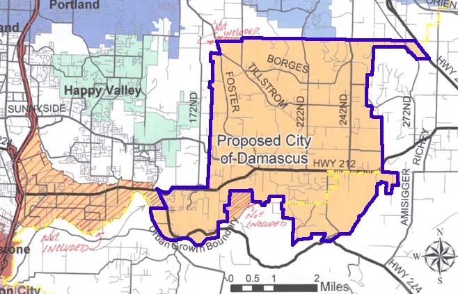
The document includes a map of what was then to be proposed as the city's corporate area. Remarkably, the original concept for the City was to extend it all the way along Highway 212 to Interstate 205, including the commercial and industrial district along that road and the area around the intersection of SE Highway 212 and SE 82nd Drive, historically the center of the area we call the community of Clackamas (I find that most people presume the area around SE 82nd Avenue and Sunnyside Road, adjacent to Clackamas Town Center, as the center of Clackamas. Insofar as commercial activity goes, that may be correct. It wouldn't be the first time a commercial district in an Oregon 'town' has migrated. But Clackamas, historically, is the intersection of Hwy 212 and 82nd Drive. Look that up in your MacArthur. Digressionary brackets end here!)
Anyway, I clipped the document out and Photoshopped in a blue line. The mileage scale is still there so you have an idea of how big the area acutally is. I eyeball it as somewhere in the ten-to-fifteen square mile range. The area is said to contain about 12,000 residents, putting it, as a community of size, somewhere between Newberg (about 17,000) and Dallas (about 9,000). The blue line excludes all areas crosshatched out as "Not Included", therefore, as I interpret this document, that blue line is most likely the new official city limits of Damascus, Oregon.
Note, to the left, how neatly Damascus forms an expansion limit for the City of Happy Valley (so much for Happy Valley's dreams of world domination). We can begin to see how big Happy valley can eventually get. Also notable is the omission of the Boring commercial center and its adjacent area (on the right margin of the map, where Richey Road intersects Highway 212). On the south it just touches the Estacada-Carver Highway (State Hwy 224), on the northeast it contact US 26, but just for a short distance. The northern boundary, with one exception on the northwest corner, is the Multnomah-Clackamas county line, thus hemming Gresham in on the south.
The historic community center of Damascus is the area where Highway 212, SE Foster Road, and SE Sunnyside Road all come together, in the lower left hand area of the city territory. Like many Oregon cities, Damascus is off center.
The most intriguing (and in its quiet way, exciting) is the parts that are crosshatched off. The envisioned extension along Highway 212 toward I205 really gets me thinking about what happened there. At what point was it decided that that area wouldn't make the cut? What factors contributed to the sketching in of those lines? Was there overwhelming opposition in that area of the Sunrise Corridor? And perhaps the coolest thing of all was the fact that this was sketched in by hand at some point in the process. They decided to make a change perhaps at the last minute. Attention wonks: this is not just process, this is change in process, a decision point captured in time. In its own small way, that was history being made. We shouldn't be surprised, I suppose, that in the future, when Damascus thinks to annex land (as cities do from time to time) that they will reach westward toward the freeway.
No comments:
Post a Comment