Showing posts with label My Best Portland Photos. Show all posts

28 March 2021

Man, Woman, Mt Tabor, and City View, Circa 2010

3797

Today's throwback photo: A man and woman sharing time on a bench with a view of the tree-covered Hawthorne District and downtown Portland as it was then beyond. A western exposure from the brow of Mount Tabor.


Many things have soured about my beloved home town, but as long as there's places like Mount Tabor and Mount Tabor Park and views like this, then it's still my beloved Portland.

24 March 2020

Plague Year Diary 5: The Emptiness of East Burnside

3620
We went out today to get a look at our world. It's gotten kind of eerie.

This and the next two or three postings will give you a look at how little activity we saw. Now, out here, in Outer East Portlandia, as I've said before, it's a little hard to call. The amount of traffic out here tends to vary and I keep a vampire's hours and weekends, so I normally see a light traffic flow. Also, though, as also noted, my impression of my flip-side surroundings has been that of a lighter throng.

This picture is of East Burnside St looking west from about 60th Avenue.

Another thing I'd like to note is that these pictures were taken mid-afternoon, on a Tuesday, at about the time Portland's now-legendary rush hour starts.


Now, this angle takes in a stretch from 60th to about 50th, about 1/2 a mile. That ziggurat in the distance is Big Pink (the US Bancorp Tower) which is, if you aren't familiar with PDX and I haven't mentioned it (and I'd be surprised if I didn't) is a 42-floor tower and the second-tallest building in Oregon at 536 feet. And beyond that is Portland's West Hills. There are 20 city blocks to the mile in PDX, so that should give you some idea of the depth of field.

I count only three cars along this half-to-three-quarter-mile stretch of East Burn. In the middle of the afternoon, in traffic-choked Portland.

It gets lonelier. Stay tuned.

02 January 2018

At Last, The 2018 SJKPDX Portland Photo Calendar!

3508/A.
I took a year's hiatus on this while other things concerned and tried to consume me. Well, this will be an art year, and what a better way to start than by re-debuting an idea that The Wife™ and many friends blandishments pushed me to in 2015.

The Portland 2018 calendar is a collection of 13 (one page has two images) photographs from my multi-year collection of snapping things in the areas around town what I live in. This is what home looks like to me, and they are chosen and curated with the same loving eye and passion that just existing in Portland does for me.

I truly love my hometown. I've never felt right anywhere else, and I hope the love I have for Portland, and the cosmic fortune I feel in being able to call myself native Oregonian, shows in my street-level perspectives.

Also! Two of the photos were taken of the Cascadian Eclipse of 2017, down in Woodburn. So you can see what I saw in a singular event of a lifetime.

The price is $12.99 before you get to shipping, and if you'll wonder why you should buy a 2018 Calendar 1 month into the new year, then understand that you also get January 2019, because I believe if you're paying for a calendar you should at least get 12 honest-to-goodness months out of it!

If you love Portland (or love the idea of touring Portland), my calendar will give you a fresh scenic take ... not the same re-used photos over and over again, like so many other scenic Portland calendars you'll see. Unique as its photographer, it's the Portland calendar for your wall.


Buy, and buy often!

24 November 2017

Old Portland, With Clouds

3528.
Today we went on a personal mission that was a something of a fail. Not a disaster, but something we could have done without.

Digital photography, though, means that no fail is a thorough fail. We at least have some photos that scream Old Portland.


NE Broadway in the Rose Quarter area. A lot has changed, but it still looks like Old Portland when you get this angle.


On N. Larrabee Avenue, which is the name of the street that you approach Interstate Avenue northbound from the Memorial Coliseum, there is this grain elevator. It's part of working Old Portland; I'm cheered by, despite all the up-towning we done around here lately, the Willamette harbor is still a working harbor all the way into the city center.

And, if you take a picture at the right moment, the city seems deserted, just like scenes out my favorite apocalyptic movies.


Fremont Bridge from the Larrabee merge onto N. Interstate Ave. Same feel, same deserted look, same cloudbank being held back by the range of the Tualatin Mountains in Forest Park.

Downtown Portland with Clouds Cresting the Hills

3527.
Sometimes, Portland's West Hills seems to bar the way for the clouds that are trying to come over them.

And all the time, with a downtown that's dominated by the hills close to hand, that's rather dramatic.


The blurriness of the photo had a lot to do with being in the front seat of a car in motion. Kind of a layer of bokeh, I suppose.

04 July 2016

[SJKPDX] My Own Westercon 69 Triumph … New Portland Skyline On The Title Page.

3333.
If you've not yet heard, Westercon 69 is now wrapping up here in Portland. The 69th edition of Westercon, a movable Science Fiction/Fantasy convention which is to Western NorthAm what the Worldcon is SFF in general, was one of the most well-attended in years, with over 1700 members; this puts it in the major leagues. With GoH's like Scalzi and Stross, Bobak Ferdowsi, a bard like Alexander James Adams, and our own local David D. Levine, and set in Portland, how could have been anything other than a success? But the success exceeded expectations.

I even had my own high point. Chosen to grace the table'o'contents, there at the bottom, is my newest Portland Skyline photo. Peep it:


So, my name and an image I made get to grace the same page with some pretty heavy hitters. I also got, as it will be recalled, to collaborate on the divising of that nifty logo, so I got that workin' for me, which is nice (thank you, Meredith!). 

30 May 2016

[pdx] Portland 2004 vs Portland 2016: Compare and Contrast

3325.
Naturally, having snapshots from back in the day and now currently, even if it's an unadvantageously-lit first-pass, invite comparisons. Here are the two photos, side-by-side orothogonally:


Some comparisons kind of jump out at you. The red brick-colored building there in the front and center, 1 SW Columbia, has a new companion immediately to the right; it's a shiny block of ice now blocking the view of the US Courthouse (the building with the curved roofline); the area of horizon between the Wells Fargo Tower and the Portland Plaza (the two buildings closest to the left of frame) has partially been populated with some of the rash of new apartment towers populating old Portland. You can even see the top of Park Avenue West (it's directly to the left of the flag on top of 1 SW Columbia).

Number and name the changes, friends. Portland's evolving, no matter what we think of it. 

23 August 2015

[pdx] Day of the Wildfire Smoke, Part 2

3219.
From Southwest Portland and the Terwilliger Blvd Parkway we proceeded east over the Hawthorne Bridge into the Hawthorne District (a/k/a Chicville, Lower Cascadia).

This was the view from about 28th and Hawthorne looking west …


… and this was closer in, about 18th Avenue or so.


It bears remembering, I think, that the points-of-view in the above two photos were in areas that were, because of the miasma, not visible from the viewpoints on Terwilliger in the last posting.


The above is looking down Hawthorne east from about SE 35th Avenue. That dark area above the horizon in the distance is Mount Tabor. For comparison, this, taken in 2014 at the Hawthorne Street Fair, which isn't in exactly the same spot … but it's close enough.


What a day, huh? This is your world … and this is your world on global warming.

Any more questions?

[pdx] Day of the Wildfire Smoke, Part 1

3218.
The numerous wildfires in the eastern 2/3rds of Oregon and Washington are usually things those of us in the Willamette Valley hear of on the news, complete with pictures and live remotes.

Usually. Because this year, since the fires are so numerous and all following the 7 Habits of Highly Effective Wildfires (Rules 1-6 read 'burn everything', and rule 7 is 'when in doubt, see rules 1-6), and since we are afflicted with yet another continental weather system providing us with abundant offshore flow (a Pacific Northwest weathercaster term meaning the winds all go to the Pacific), this hellish fire season, everyone west of the Cascades gets a taste of it, and those with respiratory issues are strongly advised to stay indoors.

The day, Saturday, August 22nd, dawned auspiciously. Red sky at morning, Oregonian take warning; the morning sun was shinin' like a red rubber ball.


The above was taken at about 0715, as I departed my work site. The morning was remarkably amber from then on; the quality of the light in the air was more appropriate to sunset than not long after sunrise. And, all that day, I found myself wondering how much worse it would get. It's a good thing I got pictures; I myself couldn't foresee how sepulchral it would eventually get.

From about noon through to about 6 PM I spent the day in the company of some of my chums from high-school, and a better gathering could not have been had by anyone. The location was in Tigard, which is as far as you can go in the SW direction and remain in the Portland urban agglomerative disk. The haze thickened over the day. By the time we left and worked our way back through Tigard, this is what SW Pacific Hwy near SW 72nd Avenue and the Fred Meyer store looked like:


… and this was SW Barbur Blvd in the vicinity of SW 30th Ave (which is the light in the middle distance):


Despite the lateness of my day, I thought a viewpoint was needed. Portland's SW Terwilliger Blvd is famous for places to park and take in the pulchritdinousness that is Portland's city landscape from a point with a view. But today, this is mostly what Portland looked like from Terwilliger:


My city was gone.

The Tilikum Crossing:


Bridge of the people; smoke from the distant wildfires. More like Twilight of the Gods around here.

And this, the Marquam Bridge:


Absolute visibility here is something less than 2 miles. Clear visibility? Much less than that.

This view point is good for framing downtown Portland with views of Mount Saint Helens. Today's shot makes us imagine downtown Portland if Loo-Wit has erupted the other direction.


Another angle on the Marquam Bridge. Those buildings are new hotels and condos in the Riverplace and South Waterfront districts.


Our adventure continued east into the Hawthorne district. About which, anon.

25 September 2014

[PDX] The View Down Sandy Blvd, The Hard Way

3150.
I was in slight danger for taking this picture. This is looking west down NE Sandy Blvd while in the crosswalk with the WALK signal favoring us. The nearest cars you see down the road there.

We were in vague peril but not imminent danger. The Wife™ stood sentinel duty.

The nifty thing about Sandy is that, from its origin at SE 7th Avenue and Washington Street to where it meets Killingsworth in Parkrose at NE 99th Avenue, it's more or less a straight diagonal line (as it ascends the Alameda Ridge, between just west of downtown Hollywood and NE 57th Avenue, it kinks right then left ever so slightly. You can scarcely see this on a map).

And it's pointed toward downtown, and gives great views as you come closer.


That big domino against the hills is, of course, my beloved Wells Fargo tower. Just as far away and just behind that copse of street trees is the KOIN Center, and with KATU just a block and a half away behind us and to our right, I noted that if you stand at the corner of NE 21st and Sandy and look down the street, you can see it, meaning you can see one major Rose City TV station from the other.

KGW is not visible in this shot, of course.

Again I used sightlines to force perspective and creat a faux-telephoto effect. Cropping out parts of this photo would result in very nice abstract-urban bits.

21 August 2014

[PDX] Faux Telephoto - Hawthorne And The Big Hill East of César E Chávez

3130.
It was said, on the Hawthorne Street Fair Facebook page, that this was the first time the Boulevard between 30th and 38th had been closed in decades.

This gave the perfect opportunity, of course, for some angles that you couldn't otherwise get else the chance of grievous bodily injury. An always-inspiring view is the view east down Hawthorne, with the street rising to meet, and appear to be utterly defeated by, our legendary volcano-within-a-city, Mount Tabor.

It will be remembered, though, that Hawthorne Blvd was named after Dr. Hawthorne, who once ran what they called then an "Home for the Insane" down near where the Hawthorne Bridge now, and the street started life as Asylum Avenue.

So, on Hawthorne, unless anything's possible and everything's a little crayzee, then it ain't right. Not really.


The above photo looks down Asylum Avenue east from just west of Chávez up tow where the street jogs south on the side of Mount Tabor. That edifice at the apparent termination of the street is the Portland campus of Western Seminary.

Notice the dude there in the lower left of frame. He's doing what I'm doing, except his only companion is a tripod. Tripods are nice, but wives are better to have around. Just my opinion, of course. Now, when  you widen the angle, here's what you see …


The loftily-named 'Mount' Tabor is merely a hill, though a most pulchritudinous one. It is an extinct volcano, and one of the western outposts of what is amusingly called the Boring Volcanic Field. A great number of small, knobbly hills spread out south and east into the Multnomah and Clackamas hinterlands; these all erupted over one period, with nary a peep since the last 300,000 years.

In short, it's dead, Jim.

The summit elevation is reported as 636 feet above sea level; the surrounds are about 200 feet above sea level, though, so that's a 400 foot hill there. Still, remarkable; of all the cities in the USA, only four are thought to have extinct volcanoes within the city boundary. Two of them are in Oregon.

When you zoom in, crop and frame, and go for a compressed perspective view, though, that's where I fall in love:


The parts of Hawthorne west of Tabor are kind of in two parts to me: the painfully cute and fashionable, which stretch from about SE 30th Avenue to Chåvez Blvd, and the more clubby section, which run from Chávez to 50th.

When reviewing the photos I was going to put there, I realized that I tend to prefer photos with few people in them. This one, with the two young dudes there, just ambling down the street enjoying life, spoke to me, saying that maybe I shouldn't be so aloof. But, just to satisfy the aesthete in me:


… here's one where you can ignore the peoples, if you want.

A few years back, when we Portlanders went through the spasmic renaming of what we then called NE and SE 39th Avenue to César E Chávez Boulevard, it was such a strange thing. Yet again, the careful rules that were agreed on to ensure that everyone … especially those along the route, who would have to spend money changing up stationery and signage … was on board with the change, were rather casually set aside because reasons. And more than a few people, of more than one ethnic POV, pointed out that it'd take more than a street name change to really address the problems that we all saw in a mere street name-change.

But the change did go through, as it did. And I don't think I'm off the beam in saying that it very much appears that the vast majority of us have not only made peace with the change, but have embraced it. I like the idea that my hometown has a street named for Chávez; it fits with the sort of place Portland's trying to collectively constantly reinvent itself as.

So when I take a picture like this:


… with the street blade settling in against the charming latticework of the windows in the façade of the Hawthorne Theater, there's something there that's never been more natural somehow. It's part of the fabric of Portland now, which has been many things, sometimes simultaneously, often contradictingly … corrupt and holy, fair and unjust, progressive and regressive, rich of heart and poor of spirit …  All of that. Depending on time you look and the angle of persistence.

Exegesis in a photo.

One more: as addicted as I'm becoming to the forced perspective, the Telepfauxto, in sizing and cropping for display, this angle and crop hit me as perfect. Just makes me happy. That's all it is here:


I love you, Portland.

07 April 2014

[pdx] Photos on Sunday 2: Downtown PDX at Dusk

3047.
On Sunday evening, during the crepuscule, The Wife™ and your esteemed correspondent decided what we really needed was a walk about on the first really fine day of the year.

Downtown was our subject. These photo entries I've tended to be posting latterly are harder to assemble than one would think. They require a level of curating that a simple wordy-post doesn't; I always have the words I need, but photos do tend to say so much that when I want to tell a story of a moment with some, choosing is the hardest part.

Fortunately, Portland is so photogenic, it tends to speak volumes for me. I do persist in insisting that my words are an important part of it; it's a conceit, and I realize this. It is, however, a conceit I freely indulge; luxury I can afford, a character flaw I am most fond of. Long story short (too late!), it stays.

But, to be brief (my schedule for today has just evinced a tectonic shift and time is short), my hometown gives me:

Great vintage signage …

NW 2nd and Couch
…the old and the new both looking ancient…

NW 1st Avenue at Couch, Looking South
 … old bridges …
Steel Bridge from Japanese-American Historical Plaza
 … funky 20th Century skylines …

The burgeoning Lloyd Center Skyscraper District
 … more old bridges …

The Burnside Bridge, which should need no introduction
 … urban history …

It is what it is.
 … modern urban prospects …

SW Naito Parkway looking south from the light at SW Pine Street

… over 100 years of bridging the river in one angle …

A view upriver including the Morrison, Hawthorne, New Transit Bridge, and Marquam (and a teensy bit of the Ross Island Bridge, as Wife™ says).
… more modern urbanity …

Downtown from Salmon Street Springs, at SW Salmon and Naito, featuring the KOIN tower.

… a view down the river wall that seems more European than American …

This angle I've seen photographed before. In a certain light, it makes me think of what I always pictured a scene along the Seine in Paris would be like. 
 … and a sunset fairyland with train tracks running down it. …

SW 1st Avenue looking south, the Skidmore Fountain at our backs.

… that's my hometown.

Must go. Life calls.

12 December 2013

[pdx] Rich, Cold Sunrise, 12/12/13

2980.
Nothing much to say here except, my gosh, the rich color!


Taken this morning near Portland International Airport. The colors are much hotter than the weather and just as memorable.

13 April 2013

[Out_122nd_Way] The Rainbows We Grow Out Here

2918.Out here, in Bedrock, Out 122nd Way™, we do everything better.

And that includes rainbows.


This is a full bow, both ends touching the ground and a complete middle. That strip center across the street holds the Pizza Baron and the Sears Service Center. This is just about 200 feet south of SE Division Street looking east over SE 122nd Avenue.

And it's the kind of rainbow we grow out here.

It's just better than the rainbows you have in your neighborhood. I'm sorry! Shut up! It just is!

It's why living out here is excellent.

31 January 2012

[art] My PDX Skyline Photo - Coming To Campaign Materials Near You

2778.Disclaimer: This posting does not necessarily imply an endorsement of the Jefferson Smith for Portland Mayor campaign, though I do understand that he's a pretty nice and smart guy.

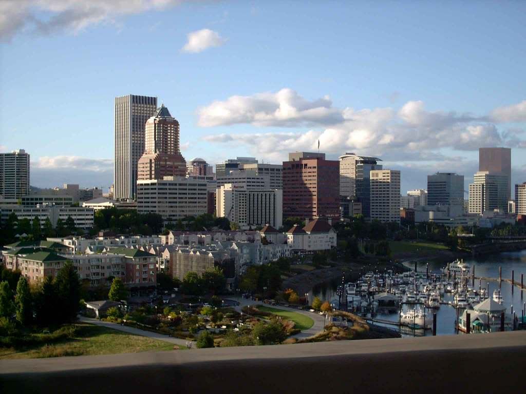
It's my extreme joy (seriously) and a thrill besides to announce that I've sold the rights to a photo which appears to be on its way to at least a semi-icon status. The photo is, of course, this one:


And it's been licensed to a designer working with the Jefferson Smith for Mayor campaign for use in campaign materials through the 2012 campaign.

I'm not saying at this point who I'm voting for, but if the people Jefferson Smith gathers about himself for campaign purposes are any indication, he'd probably make a good mayor. Friendly, coöperative, and incredibly generous in spirit.

Jefferson's campaign's web presence is here if you're so interested: http://www.jeffersonsmith.com/

In the past this photo has been used by others, both who've asked and purchased a license and … surprisingly, given my little-fishy status … those who haven't. Those who have asked and been granted permission include a (now-former) Portland-based Liberal talk-show host and a funky music-themed spot on Belmont.

In the next posting, I'll be touring some of the web-based peoples who didn't ask permission. 

27 February 2009

These Things Tend To Work Out, With The Right Spirit

1959.Just recieved a note from the Hall Of Records folks, and it was so excellent that I can't help but share it:
We're so sorry about the photo. Obviously our graphic designer didn't do due diligence on the image used. Lesson learned for next time. But thank you for being so cool about it.  You're right, we are small fish just starting out. In the essence of turning every negative into a positive, we'd love to buy you a beer and maybe even use you to do some graphic design for us some day.
I've always thought that where we can we must be excellent to each other.

May fortune smile on thier enterprise, and good instant karma all around. It sounds pretty cool.

And if you can, go to their party and have a beer and a slice for me, will you? I'll be drudging away somewhere dreary, but I'll feel a little better about things if you do this for me.

Technorati Tags: , , , , ,

26 February 2009

Hey! How'd My Photo Get On That Cool Poster!

1958.Check out this poster I found via Dave:


Now, look at the piccy I took back in March of '05:


I'm flattered, to say the least. I adore that type. The funky vibe is represented. I fully approve of the poster and my photo's use in it.

Just one thing, though. I check my sitemeter logs regularly; this must be one of the most hit parts of the blog, this picture. It's probably been round the world once or twice. One of the risks you take with putting your creative work on the web is that people tend to help themselves to it.

And I understand that. Hell, a couple of posties ago, I ripped off a photo from the PMerc. But it was satire, and they were credited.

But this photo is particularly dear to me. It was taken by me, foolishly, with my camera in one hand and the steering wheel of my '72 VW in the other, at speed, hurtling over the Marquam Bridge on cold spring morning after one of my evenings at work. I'm in love with my cityscape, and I'm in love with tthis photo of it.

So, if you want to use it, that's cool. But don't assume that I have put it in the public domain; I have not. Write me and ask. You might be surprised. I could very well just say yes, and if you're a little fish just starting out like the Hall Of Records is, the only price I might ask is that you credit me for it.

Thanks. And hey, since I'm too poor to go and work nights and weekends anyway, go on over to the Hall Of Records party for me. Have a brew and a slice in my name. I'll catch the spirit.

(Update: Checked the metadata for the photo. I actually took it in 2004 on Sept 16th, at about 11 AM.)

Technorati Tags: , , , , ,