Showing posts with label PDX History. Show all posts

03 October 2016

[pdx] The Original Design For The City Of Portland's Seal, Revealed

3386.
It's long been known that, in the secret history of the Rose City, that Portland is a town that was built on an ancient unicorn burial ground. What's less known is that the original city seal's design featured one.


Portlandia, of course, is a virgin in this depiction. Unicorns will only associate with virgins, goes the legend.

Naturally, more sober heads prevailed and we have the current boring version which features Portlandia, a sheaf of wheat, a hammer, a gear, a ship to shop the poor people out so more prosperous people can move in, and three food carts, only one of which is ever open (never when you stop by).

And so it goes. 

16 September 2016

[pdx] TriMet's Graphic Design Throwback T-Shirts

3365.
This in over the transom:


It will be recalled that, from the mid-70s,
for about three decades, TriMet made navigating its innumerable routes a bit easier by slicing the Portland area into seven color-and-symbol-coded service sectors: Red Fish (NW and N), Purple Raindrop (NE), Blue Snowflake (NE and E), Brown Beaver (E and SE), Green Leaf (SE and SW), Yellow Rose (SW) and Red Deer (NW and SW). The Brown Beaver can be seen below and to the left in larger size; the simple design of the icons meant that if you going to a certain part of town, all you had to do was find the right color/symbol to guide you to the right handful of routes. I loved this system. It had a flair and a certain Portlandesque panache that was hard to put into words.

Well, times change and so did TriMet; by the middle of the aughts, the system was beginning to evolve away from the hub-and-spoke rationale which made pie-sliced sectors a natural thing, and the multiplicity of rail lines moving through the Portland Transit Mall called for a re-think and a different approach, which works a bit better today if it's a rather characterless.

For those of you (such as me) who fondly remember the old system and don't agree that it was dated, there is a way to fondly remember to others: Throwback gear from TriMet. The seven classic sector symbols are available on t-shirts (such as the one pictured at right) and caps: shirts run in the $16.99 range an the caps run a bit less.

The address for the shirts is http://www.cafepress.com/trimet/10216648, then just select a symbol, shirt or cap, and proceed to check out.

The TriMet gear front page, which includes more than just throwback shirts, is at http://www.cafepress.com/trimet.

11 September 2016

[pdx] The Most Remarkable House In SE Portland Can Be Yours for A Very Expensive Song

3360.
At the almost-comically small address of 3040 SE McLoughlin Blvd here in Portland is one of the most remarkable houses in town. It's a ice-cream castle of a Victorian mansion, built in 1891, and it's known as the Johan Poulsen House.

Where it's at. Check it on Google Maps.
Tongues are a-wag on line in the Rose City because it's just been listed on Loopnet.Com for sale as a residential property (see http://www.loopnet.com/Listing/19903945/3040-SE-McLoughlin-Blvd-Portland-OR/). It can be yours for the asking, provided your question is made of $1,350,000.

You can't just buy style like that at the Plaid Pantry, my friends.

If you had to ask, you can't afford it.
(Image: Google Street View)
For that, you get a signature landmark with nearly 5,000 square feet of living space, and enough bedrooms that you can move your salon in. Which is exactly what I'd do. I'd take me, The Wife™, our felines, and a few friends who deserve to be admired and we'd all go there and be awesome together. Hell, I'd research the dimensions of the Algonquin Round Table, have a replica made, have it put in the room with the best view (it sits on the nose of a bluff overlooking the east end of the Ross Island Bridge and with nearly unobstructed exposure to downtown Portland and most of the inner east side, I mean, imagine the views!) and we'd just be brilliant together.

And if I was only as beloved of America as I should have been, I'd already be there. Another way in which my homeland has let me down.

Thanks, Obama. 

14 July 2016

[PDX] There's A Hip Name For Portland East of I-205, or, We're Doomed, Midlanders

3346.
Come to Outer East Portland, says I to acquaintances. We have dive bars!.

Would it be that I were not so blithe then, this news wouldn't intimidate me so, now.

A few years back, I figured I'd be a bit puckish and poke fun at Willamette Week's then-worldly-yet-parochial "Best of Portland". 2008, it was. You can read it here: http://zehnkatzen.blogspot.com/2008/07/pdxmedia-wws-best-of-portland-if-you.html. Oh, I was in rare form. Amongst the witty observations I made then:
WW adds to the disrespect; you see, as far as the "Best of Portland"goes, the wittily-named "districts" that the publication uses to give character to town only go as far east as I-205. That's right, Midlanders, take it on the chin again; as far as WW goes, you aren't really cool enough to even be in Portland. Even though you are in Portland – at least out as far as 164th Avenue north of Stark, and 174th Avenue south of it.
In green: Outer East Portlandia, hereinafter
known as the Region of Thud.
Well, in the time since 2008, Portland became Portlandia, rents zoomed up eight million percent, and a fear and loathing about how Portland's growing and what kind of people will be entitled to the right to be Portlandian has grown and flowered to levels we couldn't even envision then … hell, in 2008, a person making minimum wage could still afford an apartment in the grottier sections of inner SE. Those grottier sections of inner SE are largely gone now; condominium design bordering on the brutalist now dominate the stretch of Division west of SE 52nd Avenue, and what were once vices confined to the tonier parts of town have now become habits. And the people whose fortunes are meaner than that have slowly been priced out and have moved east … to Outer East Portland, David Douglasland, Parkrose, these areas that still have some of the feeling that most of Portland east of the Willamette had before 2008.

The area I live in … trans I-205 … has become the most ethnically and economically diverse of the city.  It's also fairly populous: statistics posit that approximately 21% of Portland's estimated 2016 population of about 609,000 live between the freeway and Gresham. That's about 130,000 people, and if that were a city of its own (an approach which has been explored more than once) it would be larger than Gresham but smaller than Salem … Oregon's 4th largest city.

So, a couple of weeks back, I held in my hands the issue of Willamette Week that finally turned its attention to my side of town. And I had a sick feeling over it. Because it was one of those bits of reporting that delighted in how authentic, interesting, and funky a previously-unregarded area was. Two attractive young people featured as the iconic explorers from the west side of the freeway, hip, young and ready for any urban adventure.

The reportage is sobering, studded by such verbiage as:
The long-maligned 80ish blocks between I-205 and Gresham are home to many, many strip malls, but the area may also be beginning its own renaissance—think of it as our Oakland.
Think of it as our Oakland.

Oakland is across the bay from San Francisco, as you geography students will remember, and we all know what happened in San Fran, don't we?

I don't see any of this ending well.

And that hip, new nickname for an area of Portland people west of 82nd used to think of a Gresham? What the kids today call us? Well, we have a variety of names for our area of town: the David Douglas community, Midland, some Democrats, inspired by Jefferson Smith, call us Bedrock. But none of those names obtain amongst the fashionable, no, … they call us …

The Numbers.

The name makes little obvious sense. I remember first seeing the coinage on Facebook in the group Damn Portlanders about two months ago. Someone mentioned that the lived on Division, out in the numbers. I didn't know what that meant then, but I do now, but the inspiration for the rubric defies sense to a degree. We have as many named streets as numbered streets, and we have about as many numbered streets as other areas of town. It's like some fashionable-person cabal threw darts at a board with words on, got numbers and said "yeah, that's enigmatic enough. That's what we'll call it". For Outer East Portland, it's like getting the Black Spot: we're next. The first wave, the slummers, have already trickled out this way. The WW spread features a well meaning paragraph promising insights, reading:
East Portland is the future. It's younger, it's more diverse, and it's about to become a lot more central to what we talk about when we talk about Portland. Here's your primer.
Naturally 'your primer' to the future turns out to be a list of what to go see, do, and eat, and where to have a good time. So much for insight.

They may call my area of town … which had many fine names but they couldn't leave well enough alone … The Numbers, but I'll be thinking of it as the Region of Thud. Discordians will know what I mean. The sense of attendant doom is similar.

My own acidic view of those days, which has unexpectedly presented me with a petard upon which I've rather hung my younger (and current) self, possesses this penultimate note:
Indeed. Certainly there must be a similarly-witty name for this area east of I-205, where, apparently, Willamette Week reporters fear to tread.
Well, not only do they no longer fear to tread out here, they've answered my sarcasm with the utmost of ironies; a sincere and fashionable rebranding. Vanity of vanities. And to the rest of my Midlander bretheren I have only this to add:

Buckle up, Midlanders. It's gonna be a rough ride.

They've seen us.

They certainly have our Numbers.

18 March 2016

[pdx] Sellwood Bridge Bonds: Same As It Ever Was …

3307.
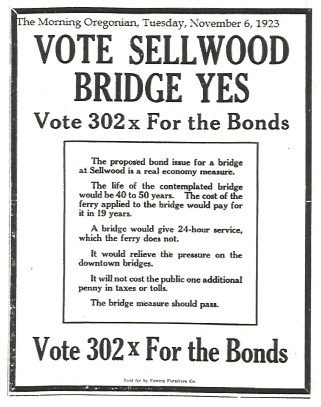
One of the bits of ephemera given out at the Sellwood Bridge grand opening a few weeks back now, was this, printed on the back of a card given out by the Multnomah County Elections Dept to encourage y'alls to use your damn' franchise. Here it is. Most ironically illuminative:


It enumerates the various benefits the bridge would bring. Most unintentionally amusing is the point that The life of the contemplated bridge would be 40 to 50 years. The ad, as the attribution notes, was published in The Morning Oregonian in November of 1923, and the bridge would actually debut just slightly more than 2 years hence.

Given the cited lifespan, the old Sellwood reached its pull date in 1975. Interesting to think that they figured that a 50-year bridge would fix the need adequately. And, of course, the debate over taxes is an evergreen one.

Also, those fonts? Love those fonts! Those fonts just speak loudly of their time.

03 March 2016

[pdx] A Last Look At The Centennial Mills Building

3285.
The ancient Centennial Mills building, on NW Naito Parkway between NW 9th and 15th Avenues, is going away, deemed to expensive and risky to renovate and preserve by the developer that now owns the property, as we are hearing. While the Portland Police Bureau's Mounted Patrol's home seems to be staying, they're tearing it down now. While I was at the OSU Food Innovation Center participating in a taste test ($40 for between 5 and 7 ounces of pears ... not a bad rate but I wouldn't want to be doing it all day), I got a shot of the side that's not-so-torn-down. It'll probably the the last time I see it up.


Abysinnia, Centennial Mills.

17 September 2015

[pdx] Portlandia, Where You Bound?

3230.
Some time ago, I forget where, I opined that so many people think Portland wants to grow up to be Seattle, but they're wrong … Portland actually wishes it were San Francisco.

Following the news about the techsters taking over there, and the boho, artistic SF culture that the city was famous for being driven out in some sort of human expression of Gresham's law, and following the current news about rents whizzing upward towards some sort of physical escape velocity that is currently driving lower-income workers and renters toward the margins (and perhaps even beyond in the near future), it's hard not to, at least, disagree with my own past thoughts. Portland is becoming SF-like, in all the wrong ways.

On SE 8th, just off Hawthorne, is a basketball backboard, It's in the shape of the state of Oregon, but says Welcome to California. It's gotten some legs. Inspired by that, I offer this little bit of agitprop.


26 May 2014

[pdx] Photos On Sunday: The Burnside Bridgehead

3096.
The block on the north side of the east end of the Burnside Bridge has something of a conflicted history. For a long time, nobody knew what its future would look like. Many people had some definite ideas, but in the end, none of them willed out, in a way that's funny in bike-friendly, liberal, weird Portland.

This block is bounded on the south by East Burnside Street, on the west by NE 3nd Avenue, on the north by NE Couch Street, and on the east by NE Martin Luther King Jr Blvd, once known as Union Avenue. I became a full-time Portlander in 1985 (with a break from '87-'91, but that's another story) but, by then, being a perhaps-too-avid watcher of the news, had familiarity with at least some of the issues surrounding that square block of Portland.


When I finally did come to the shining city, I knew there was a place of no small notoriety there, and that was sad, because they really did try to fix something. The building on the north side of the bridge was a place that looked disreputable but tried to have a good heart – they called it Baloney Joe's. It was a homeless shelter run by an organization that dissolved in a scandal involving the director, an organization called the Burnside Community Council, and that's sad because there were some good angels hard at work there, some of whom you might know if you hang around the good Portlandians online.


Sometime around 1990, due to the scandal, the BCC ended and Baloney Joe's operation was taken up by the Salvation Army, who renamed it the Recovery Inn, then developers got interested, and the Inn finally closed and moldered for several years while a variety of power and money centers vied for the opportunity to develop it.

Someone wanted to put a Home Depot store there. I, for one, still can't picture it.


Today, the battle has been settled. When whoever thought it was going to be a bonnie idea decided to turn Burnside and Couch into a one-way couplet east and west of the bridge, they needed a place to funnel the west-bound traffic on NE Couch onto the Burnside Bridge westbound. Instead of a Home Depot or lower-income housing or anything regarding the homeless, now, an S-shaped boulevard full of traffic runs through it.

In liberal, weird, transit-and-bike-friendly Portland.

Who says irony is dead? As long as this absurd city remains, thus shall it be. And the debate over what could have been shall 'ere be considered academic.

The skyline of the down, dirty, yet somehow fashionable
CEID looking south from the Burnside Bridge.

The Burnside Bridgehead exists in what was, and still shows many sides of, what we locals called the C.E.I.D – the Central Eastside Industrial District. It's starting to give way to converted loft work/live spaces, trendoid bars, and retail … which, one supposes, was just a matter of time, given that it was in sight of the city core.


The part of the block not given over to the Couch Street connection is carpeted over in long grass and wildflowers. The part of Couch that used to connect SE 3rd Avenue to MLK is now a very short stub which provides convenient and ready parking on a Sunday afternoon to the tyro photographer and his wife, and an opportunity to stretch the legs and look at the urban views.

We all strive for more than just the basics. This is not
Portland, this is universal.

The building on the south side of the bridge at 3rd Avenue has had a sign on it for decades: R.J. Templeton Co. Whatever R.J. Templeton Co, did, it's been gone perhaps even before your humble interlocutor came to town; one remembers the facade mostly bland painted wood where windows must once have been. The windows are back and whatever is going in behind them, you can bet it's going to be pretty spiffy and, no doubt, priced to match.


The area is popular now for skateboarders and bike riders, who have carved their own paths to and from Burnside down to the lower streets. Down closer to the river, along 2nd Avenue, is some of the last 'industrial' businesses in the area; some of Portland's oldest produce merchants are still there, a remnant of what was once so many that they named the area Produce Row. Set deep within the industrial haven, it took advantage of the quick freeway connections and rail access to be a break-in-bulk point for the fruits and veggies coming into and out of Portland.

The era is closing out so very slowly though. We do things in our own time here in Portland, and this is on a timetable of its own. Farther down 2nd, under the Burnside Bridge itself, is a skatepark that went from outlaw to legitimate. We saw murals (which I'll go back and get sometime) and people getting ready, complete with cameras for posterity's sake. We indeed have come so far.

The path from E Burnside down to NE 3rd Avenue.
You can go your own way, baby.
The building in the distance is the Eastside Exchange,
the building addressed with the No.123
rubric seen earlier in this post.

They say that weeds are wildflowers out of place.
Like the homeless people that used to shelter here, they'll
be evicted in their turn, perhaps.
 
Looking under the bridge at SE 3rd Avenue from NE 3rd Avenue.

Today, the old gives way to the new, a streetcar runs where once traffic did, and it all looks kind of the same, but something more than the obvious seems to have moved on. But this is Oregon, and that means …


… we'll always have the blackberry bushes.

ON EDIT: Fellow PDX Facebooker and curator of the Dead Memories Portland group, Michael Long, shares the news that they are going to put something in more than just a road there … and the idea is so very, very us. It's a real dumbbell …

27 November 2013

[logo] Lloyd Llogo: The Most Portlandest Of Malls Gets A New Graphic Llook

2961.Portland's Mall is re-imagining itself.

The Lloyd Center is pretty much the point of entry of the Mall into the culture of Oregon. Built in 1960, once opened, Oregon shopping joined the national scene in as much as the modern shopping mall is concerned.

It's had its ups and downs; it went from a 100-store mall with an open courtyard to a completely-enclosed mall with two levels of shopping and one of offices. It's really going strong, and considering how some malls have died, are dying, or have re-imagined their own selves into sere multi-acre parking lots surrounded by big boxes, that's no small feat.

For many years, now, its logo looked like this:


… and this wasn't too bad. The rose-as-an-O was very appropriate design, and I always thought the type was rather restrained and refined.
The center has undergone a change of ownership, and the new owners have deemed a logo refresh is in order. Delving back into its 60s-past, here's what they came up with:


A report by KATU-Channel 2 relates that the new owners feel as though the design harkens back to the Center's original 'retro charm'. I can see this. The design would tessellate very nicely into one of those latticework dividers so popular in the hip, upscale pads of the 60s.

I must admit, it didn't take off with me right away. I didn't much care for the asymmetry, though once I pictured it as a wall texture, it clicked right there and then. It was a quirky inspiration, to be sure, that caused the designer to link three of the open circles with the L, leaving the one bolded into a C to stand outside, but after sifting the design in my head for a while, it works.

At least it does succeed in evoking a retro feel, and as far as that goes, it's a success.

27 May 2012

[pdx] Downtown Portland: The Good Old Days Weren't That Long Ago

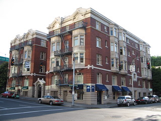
2832.John Chilson, the esteemable chronicler at the helm of Lost Oregon, has shared an album of what he calls 'Recent Portland Losses'. This is an album of stuff that has been razed in aid of putting something else there.

These were the Rose Friend Apartments.

Rose Friend Apartments Prior to Demolition - May, 2006


They were on the southwest corner of SW Broadway and Jefferson Street.

This was in 2006, just six years ago. What's there now? Take it away, Google Maps


It's a condo and upscale retail tower. Does anyone care what the name is? Given what it replaced, I don't, not really At least they saved the Ladd Carriage House, just in sight to the right of the tower there, rather famously moving it a few blocks west in typical Emmert style, but can we really say what's been put there was better, when this:

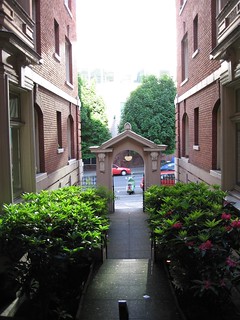
Rose Friend Apartments - Courtyard and Entry Arch - May 29, 2006


… seemed just fine?

Can you really blame the people who moan all the time about how something in Portland these days is only worth something if it can be replaced with something else? Can you really say they're moaning? I think they have a point.

Now, I know I'm quite lucky to be able to call myself a Portlander. We have a sense of history here, and despite what's been deleted from the public view in just the last 10 years, we actually have more of our history than most places. I know a guy in Phoenix who laments that whenever anything … anything … is more that 10 years old it gets pulled down in favor of something else.

I think we can do better than we have been though.

This circumlocution actually was in aid of a goal. This album crystallized something for me; when me and The Wife™ returned to Portland after a break in Corvallis, we went downtown as often as we could. You couldn't pry us out of that place. So much charm. There were nifty places and shifty places. There were new places and gritty places. I saw Waiting for Guffman at the old Music Box Theatre, on Yamhill between Broadway and Park. The block of Broadway between Yamhill and Taylor was beautiful with its Fox and Music Box marquees. Anyone remember Barbara Clark, Social Stationer? We browsed there once. Where the Columbia Sportswear store is now used to be a food court business, Metro on Broadway, where all sorts of colorful downtowners would eat.

That's all gone now. Downtown is kind of a sterile thing, a sanitized vision for the office workers and the hotel patrons we seem to lust after in an unseemly way, and the über-prosperous condo dwellers we wish would fill those towers. Downtown Portland looks wonderful, but it's gotten just skin deep.

There's very little there there any more, to kype a thought from Gertrude Stein.

Me and The Wife™ now spend our time in Montavilla, along Hawthorne, places that still have a little soul to them. Foster and Powell, a bit of Woodstock, and our beloved Russelville, which even has a cart pod of its own now. But we almost never go downtown. Why bother?

It's our downtown any more. Not really. It's someone else's.

Did you  know that there used to be an Arctic Circle restaurant on the corner of Broadway and Yamhill, on the first floor of the Jackson Tower? And you could get yourself a bit of soul-satisfying junk food and sit at the big window and watch the Square and Broadway. Nothing like that downtown now, certainly not that's not overpriced and effete. I couldn't picture myself sitting in The Original watching the world go by (and neither could my budget, for that matter).

Sic transit gloria mundi, I suppose. One must live with it.

Here's the rest of the album, from Mr. Chilson. Give him propers; he's an Oregon transplant that loves Oregon history more than most Oregonians I know, and as a native-Oregonian, I say he's doin' a hell of a job.

Here's the link to view the rest: http://www.flickr.com/photos/9807122@N08/sets/72157601847946673/.


What a difference 10 years can make.

17 April 2012

[pdx] Urban Archaeology: At SE 42nd And Hawthorne, Where They Once Sold Ice Cream

2797This was a pleasant find to stumble upon, all the more so because we weren't looking for it and it concerns the continued success of peoples we are quite fond of.

I have exulted the charms. of Muse Art and Design before. Along with I've Been Framed they are the two art supply stores you must know if you need art supplies here in town. Local, passionate about what they do, and won't break your bank wide open.

Last we, me and The Wife™ slid along to the corner of SE 42nd Avenue and Hawthorne Blvd, upper Hawthorne, and we were amazed to see this:


Muse's current location is one address east of this (more on that allusion perforce). Until recently that location was a quirky, cool vintage shop called Shadowhouse Collectibles who, via the vicissitudes of business these days, had to quit the location and move on (we don't know where yet – if you never visited, you've missed out, my friend. Keep up to date with them here, as they say they'll be back). Shadowhouse has been good to us, as the vintage KATU sign will attest.

Alas and alack, for now Shadowhouse is gone. This has opened up an opportunity for Muse to move into a bigger space, which can augur nothing but good; but until then, remodeling of the space happens. And that has uncovered and unexpected visual treat.


The building on the corner SE 42nd and Hawthorne has had her makeup removed for a newer application, and we find that this used to be an ice cream shop.


The Portland Ice Cream Company, to be precise. I don't know whether they made it there or had it brought in, but the old hand-painted typography on the facade brings up memories I didn't know I had (mostly because I wasn't alive in the 1940s).


The old paint work itself shows signs of revision. We peoples, we just can't leave things along, can we? I'm guessing that the half-covered signage probably said something like Farmers Ice Milk and Cream, but we are certainly guessing there.


Old-fashioned ice-cream parlors. Doesn't that just speak 'small-town America'? One wonders what the then-denizens of upper Hawthorne would think of the current, with the ironic bars and the organic markets and the incense-and-peppermints shops and whatnot. Probably think they were on another planet or summat.


It would be far amiss if I didn't mention something about the remodeler. The job is being done by an outfit called Michael Cordes Remodeling, and we met the man as he was cleaning up at the end of what was obviously a long, productive day of work. There are all sorts of builders revising Portland at the present time but I don't think I've ever run into one that has this keen a sense of history. Very, very affable fellow; had a few minutes to talk and we had a fairly fun chat. But, you tell me … what remodeler would care enough about history to post a picture of the building in its heyday? I'm not sure what year this was, but the old-style street-blades on the corner suggest the 1940s.


As far as I'm concerned, anyone who formats his business card and sign in lovely calligraphy is probably a cut above the rest. He can be contacted at mcremodel@rconnects.com, if you're of the bent.
He's said he has some more historic PDX photos to share after I post this, and i can share some, I will.

Keep your eyes open, peoples! History is right in front of you betimes.

21 February 2012

[pdx_liff] The Bits Of PDX Broadcast History You'll Find In Hawthorne Junk Shops

2783We are now the proud owners of a sign. But this is not just any old sign.

Portland's Channel 2, KATU-TV, signed on in 1962. It became an ABC affiliate in 1963.
The wooden shadowbox backing up this bit of translucent plexi (or Lucite, maybe) denotes it as having a vintage of 1958, though that's when Fisher Broadcasting (then Fisher's Blend Station, Inc) received a construction permit for KATU. Don't know if they knew that was when they were going to get the network affiliation. The provenance for the objet is still rather shrouded in the mists of time.

The sign looks like thus:


The translucent plastic sign can be slid out because of the missing bit of metal frame on the right. A small 40-watt appliance bulb lives in the box and looks about as old as the rest of the sign. The crafting and cutting out of the plastic forms used to create the logo's forms is as precise and immaculate as you'd want to see. This was a labor of love.


This appears to be a sign that could have hung in an office window or been mounted on a wall somewhere. How this might have occurred is far from evident. The only idea of provenance we have is the sticker, whose date must be held in some doubt. However, the design of the sign looks identical to the logo design on the television cameras I've seen in historic shots of it. It might not actually date from 1958, but it could easily have dated from around 1963 or so.

The station, KATU, is owned by Fisher Communications. Back in The Day™, it was known as Fisher's Blend Station, Inc. Kind of an awkward name for a media conglomerate. As I understand Fisher's history, though, the company that evolved into Fisher Communications began life as the Fisher Flouring Mills in Seattle, circa 1910 or so. Their most popular product was Fisher's Blend Flour. If you had a Fisher's Scone … a yummy little number made of a piping hot biscuit made of Fisher's flour with warm jam spread inside … at any Pacific Northwest State Fair through the sixties and/or seventies, then that was from the same company. And, early on, Fisher's Flouring Mills apparently realized the value of broadcasting in spreading the word about their signature product … Fisher's Blend Flour …via the new medium. One thing probably led to another, and the next thing you knew, Fisher's Blend was a broadcasting company too.

Fisher Communications have come a long way from their flouring beginnings. Fisher's flour is still made and Fisher Fair Scones are still served, but they do not seem to have a connection to the communications company any more. C'est la guerre, mon cher. 


On the way home there was some discussion over where it might go. Being broadcast graphic design, I felt very possessive about it and thought about some way it could come to the basement to live in the studio with me. But The Wife™ made an excellent gestalt case for it living upstairs in the living room, where everyone we'd have over might see it. And we'd get a chance to brag, of course, thought I to myself, thought I.

So it now occupies a position of honor in the main room upstairs, less than three feet from the TV screen, on which we watch KATU (well, as long as the digital signal will let us). And, in the dark, why, it looks so very warm and nostalgic …


Warms my heart to have this under my own roof, it does. I am a lucky person, in a way.

While I was writing this, The Wife™ sent me a link to a picture of DX reception of KATU from about 770 miles distance. The newsman in depiction is Rick Meyers, a newscaster I liked quite much, when I was a little tiny guy: http://www.johninmontana.com/oregon/katu-id.jpg.


And, as long as Shadowhouse's loss is my gain, might I suggest that you all keep an eye on http://www.shadowhouse.net, Shadowhouse's web page. They still got great stuff there, it's almost all half-off to reduce the wear and tear of moving it, and when they get a new location, that's where you'll find out about it. 

26 January 2012

[pdx] Like A Troubled Bridge Over Water: The Sellwood Bridge Construction Cam

2773.Your tax dollars at work, Multnomah County (but not yours, Clackamas … just sayin') Just announced via email: the Sellwood Bridge project's webcam.


Clicking on that excerpted piccy should get you to the page at http://www.sellwoodbridge.org/?p=construction-camera; if it don't, just click that link I put there.

The camera is, as you can see, on the east bank just about a block north of the bridge and pointing more or less WSW. On the right on the west bank is the old Staff Jennings marina; the hills beyond are swathed in the necropolis known as Riverview Cemetery. It's a beautiful place along the river there, one we much enjoy.

What's apparently happening now is that the crane in the river is doing preliminaries for the temporary supports the old bridge is going to be moved over on, where it will be a stand-in for the new span.


23 October 2009

[blog] My PDX Street Typography Photo Featured At Portland Building Ads And Other Vintage PDX Signs

2243.If you're interested in Portland streetscapes, funky found typography, and Portland visual history as I am, then you already have Portland Building Ads blog (http://pdxbuildingads.blogspot.com) in your blogrollio somewhere.

So, when the proprietor thereon asked me if he couldn't use this picture:


To flesh out a visual history of the corner of SW 17th and West Burnside, I naturally said "hells-to-the-yeah!"

Thanks to Dan for the query. I'm only too happy to assist, because when it comes to Portland visual history, I'm all over that. And flattered too!

If you like vintage type and vintage signs, too, he cited a local blogger who does vintage Portland sign reproductions. His name is Peter Vogel, he blogs at The Nutmegger Workshop: http://www.nutmeggerworkshop.com/, and the works on offer are supremely charming and attractive. So, go, do that thing there!

Technorati Tags: , , , , ,

21 October 2009

[pdx] PDX Street Sign Shop, Ca. 1916

2240.Fellow street sign blogger Eric Fischer, whose San Francisco work I've praised, has done me a definite solid and dropped a very beautiful thing my way.

As I may have alluded to in another post somewhere, Portland's street  blades have looked different. From, I'd estmate, around 1900 through the middle third of the 20th Century, PDX Street blades where these indesctructable iron things, with white and enamel paint, which looked like this:


As you can see, it's very utilitarian. Blocky, almost-military letterforms – not graceful, but very very readable.

In a recent comment to the Cyclotram's P13 Stark Street Milestone, fellow street sign blogger from San Francisco (whose work I enjoy) Eric Fischer pointed me to a most amazing publication, in the public domain and available in its entirety on Google Books. It was in this book, Municpal Engineering Practice, by A. Prescott Folwell and published in 1916 by Wiley and Sons (a book generally about designing and laying out cities), that I found the following view – the inside of Portland's sign shop, ca. 1915 or so:


You have to embiggen this to see it in its full glory, to do this, go to Posterous here and click on the photo (which you can also download) or click on the photo above.

Lined up along the bottom there are signs for E. 70th ST. N (today's NE 70th Avenue), E. 72nd ST. N., 50th AVE. SE (today's SE Raymond Street), and 41st AVE SE (today's SE Gladstone Street). I also see a rather big blade, reading (on two lines) PATTON ROAD/COUNTY ROAD, and there are signs for CRYSTAL SPRINGS BLVD, WISTARIA AVE, and possibly a deprecated style for WASHINGTON ST.

To go over it real quick again, before the Great Renaming of 1933, numbered streets east of the Willamette and north of Burnside not only carried the East prefix because of that but also the North suffix to extend west-side naming practice east in a uniform way; therefore 11th Street east of the Willamette and north of Burnside would be EAST 11TH STREET NORTH. The avenues suffixed SE were in the area south of Powell and east of E. 39th Avenue which, for reasons even not yet clear, had number congruent to today's street blocks going out in both directions, though avenues ran east-west and streets north-south: therefore, 1916's 50th Avenue SE would be today's SE Raymond Street, which is the 5000 block (50th standard street name south of East Burnside) and 41st Avenue SE would be SE Gladstone Street – today's 4100 block (41st standard street name south of East Burnside).

The viewer can no doubt find some things that I've missed, and it's all interesting and good.

Thanks Eric … you definitely da man!

To view the page directly and download your own PDF of this book, surf to the following:

http://books.google.com/books?id=7AJLAAAAMAAJ&dq=%22street%20name%20signs%22&pg=PA295#v=onepage&q=%22street%20name%20signs%22&f=false

Technorati Tags: , , , , , ,

17 October 2009

[pdx] Stark Street Milepost P13 …

2237.… atul666 can haz it, in Gresham:


… it's that little obelisk by the sign post. Probably knocked down by a road crew; lovingly replaced by the Gresham Historical Society.

The picture above is small and hotlinked (with apology to atul) to make you go and read his entry, which is highly skookum.

Cleveland Avenue (historically SE 235th Avenue) and Stark Street.

Check it.

Technorati Tags: , , ,

07 October 2009

[pdx] More Portland Milestones

2220.As pointed out by Cyclotram's Atul666 in the previous post's comments, there are more milestones around Portland than just the ones on Stark Street.

The reading I did on Stark Street Mile Markers blog suggests that there could well have been a system of mile markers on all four major routes into and out of the city. Not just east (Stark Street) but West (Canyon Road), North (Saint Helens Road) and South (Capitol Hwy) as well.

Stark Street's markers seem better preserved than the rest. The claim gains a measure of credibility when we find that there's another P7 milestone – but which is preserved today, perhaps not exactly in its precise position, at the corner of the property on which the Multnomah County Library's Capitol Hill Branch now stands:


See the tagged Flickr stream containing the above photo, taken by Chris_G_OR, hereabouts. It's got bits of history in it that make for intriguing reading (such as, e.g., the name "Taylors Ferry Road" used to go down what we now consider Capitol Highway).

Technorati Tags: , , , ,

05 October 2009

[pdx] The Stark Street Milestones

2219.Some time ago I fancied going out and finding milestones along SE Stark Street. The one I found looked like this:


This is on the northwest corner of SE 117th Avenue and Stark Street, at the corner of Ventura Park. As it turned out, there was a whole system of these small obelisks along Stark, going from the Willamette River at the east slip to the Stark Street Ferry (how you got across the river there before there was a Morrison Bridge) all the way out to what was to become Troutdale. Each small obelisk contained the letter P with a number representing the mile; P7 is 7 miles out. Stark Street – then, Base Line Road to signify its alignment along the Willamette Base Line – was one of the main routes into and out of Portland, connecting as it did to the old Columbia River Highway through Corbett and thence east to The Dalles, Hood River, and points east.

My plan was to find each one that the explanatory sign at 117th and Stark said were still extant and photograph them. As it turns out, some others are already doing this (hey, no foul; I can still go out and do it – and now I have a guide).

Atul666 at the blog Cyclotram had the same idea, and he'd been having just a little more luck than I did. He found milestone P5 in Montavilla, at the corner of SE 78th and Stark, tucked behind a dumpster (I've hotlinked this image):


Atul has also found P2, embedded within the wall of the Lone Fir Cemetery, near 23rd and SE Stark. You can read his words about it at http://cyclotram.blogspot.com/2009/10/milestone-p5.html.

But someone who's done the yeoman's job about this was someone identifying himself simply as Jeff at the blog http://starkstreetmarkers.blogspot.com/. In only two witty posts, he explores the idea of the Willamette Meridian and Base Line, and the idea of milestones along not just East but North, South, and West roads into and out of Portland.

Thanks to Jeff, I have pictures to go take and prattling to do. What Jeff did is, no more and no less, a public service.

Technorati Tags: , , , , ,

02 October 2009

[pdx] The Tom Peterson & Gloria's Too! Coffee Mug

2216.Those who know me know that one of my cherished (and most unattainable) dreams would be to find, at a bargain price, The Tom Peterson Alarm Clock.

That we shelve to the status of a cherished dream still, however, on Wednesday, in a vintage shop on upper Hawthorne, me and The Wife™ found this little darlin' for just a couple of bucks:


And, yes, it's in use right this second. Yummy coffee!!!

(Yes, I am a connoisseur of the history of Tom Peterson. Just put that string in the search box up top and you'll see my compiled notes on the subject).

Technorati Tags: , , , , ,

27 September 2009

[pdx] The Interstate Bridges From See Level

2213.Take a walk with Cyclotram's atul666:


And read all about it here. A very close and needful look at a very historic structure.

It's easy to forget how important to the mid-20th Century Portland-Vancouver population a way to get across the river was.

Technorati Tags: , , , , , ,