Showing posts with label Portland Street Blades. Show all posts

15 June 2021

Thorburn and Gilham

3945

You have to be watching very carefully to know when you cross from one street to the other here, because it won't seem like you have changed from one street to another at all.


SE Thorburn St and SE Gilham Av serve one main purpose in the Portland traffic greater-scheme-of-things: channelling traffic from E Burnside St at a point just east of E 67th Av around the shoulder of Mount Tabor and down through Montavilla on the Stark-Washington couplet. Though one is technically an avenue and the other a street, due to their layout, which respects the topography of that side of the mountain in order to have terraces for salable housing lots, they meet at such an acute angle that if it was any smaller they'd be parallel streets.

At any rate, SE Gilham Av is the most advantageous connection to Thorburn east of Gilham which goes from a 2-lane neighborhood street with speedbumps collecting traffic from Stark west of Mount Tabor to a four-lane boulevard after Gilham merges in. There are an annoying lack of of visual cues to hint to the driver they're actually on a different street now, reinforced by the way the grading directs traffic.

Long story short, if you want to just get to Montavilla off East Burnside, just go with the flow. If you want to know which street you're actually on, look sharp; there are weathered signs hiding in the foliage.

28 May 2021

A Rather Unusual Street Blade-Woodward and SE 6th

3908

This is a set of street blades that've been here for a while, as evidence by the obvious weathering.


This is, for sake of reference, one street north of the east end of the Ross Island Bridge and one block east of SE McLoughlin Blvd.

The oddities are manifest. The flat sheet metal of the signs; the rounded rectangle serving as a border, and the ordinal suffix on the number 6 being as large as the number. 

What really gets the attention is the specific; this is not SE 6th St, but SE 6th Av. But the CoP put it up, god knows how many years ago, and since it's in a forgettable corner of town, it pretty much remains. But then, we've seen evidence that whoever posts street blades for the CoP does kind of a sloppy job of it betimes. 


27 May 2021

As Though I Were Behind The Dairy Curtain

3907

The main plant for Darigold, a dairy co-ooperative that sells dairy products all over the western USA, is located just north of the east end of the Ross Island Bridge here in Portland. It's a factory and office complex located generally between SE 6th and 8th Avenues and north of Woodward Street, constructed during the 50s or maybe 60s with details that look mid-20th Century.

There's a sign on the top that, when the support was lit, with red neon, made it like a landmark beacon coming home in the middle of the night when we lived in the Brooklyn neighborhood.


25 May 2020

SW 4th And Harrison

3679
The street blade set caught my eye because there is something so pleasantly urban about the way it contrasts against the new-as-new-can-be building behind it. I also like that the block is 1850, not an even number; an address quirk about Portland I'm happy to say that they can't get rid of.


This is in the part of the city center that's south of SW Market St, which is the 1600 block south of West Burnside. SW Harrison St is three blocks south of that, but instead of a full block it only gets a half block; 1850 instead of 1900.

There's a reason for this, and it has to do with the end of canted downtown blocks, which align to the river, and the part beginning at SW Lincoln St, which is the 2100 block, which runs more cardinally east-west and begins the more cardinally-oriented grid south from there. Lincoln was designated 2000; SW Mill St, one south of Market, was designated 1700; SW Montgomery, 1800, SW Harrison, 1850; SW Hall, 1900; SW College, 1950; SW Jackson, 2000; SW Clifton, 2050. These all occupy a wedge of land which starts narrow on the east and widens as you go west at the point there the grid straightens out, and while the streets continued to march southward at the rate of one every 220 feet, the north-south address blocks on the numbered avenues were stretched to fill by 2 every hundred numbers, to even out at 2100 by the time they, either notionally or physically, crossed Lincoln Street.

Not all of these streets exist on the ground, of course; a great many were erased by urban renewal in the 1960s, construction of the Stadium Freeway and, in some places, ground too steep to build a street on. But it's a fun pattern to suss out.

23 September 2018

The Advent of SW Harvey Milk Street

3571
Southwest Stark Street is no more, kinda sorta, for a five-year transition period.

But the street blades honoring the late San Francisco Supervisor Harvey Milk are up now. And for the next five years, the street will wear both names on the signposts. This is how we transition street names here in Portland.


The proposal by the businesses along the street supporting it and detailed at The Harvey Milk Street Project  was to have the thirteen blocks of SW Stark Street renamed only, in honor of Harvey Milk who, in his highly visible position as a legislator in one of America's pre-eminent large cities was amongst the first openly gay people ever elected to such prominence, was assassinated in 1978. Also, for a period stretching roughly from the mid 1980s to the mid-2000's, that area stretching along Stark from approximately 11th Avenue to 13th Avenue was the hypocenter of Portland's gay culture.

The list of nightclub names still doubtlessly rings legendarily in the hearts and minds of Portlanders gay community: Club Portland, the Fish Grotto, Boxxes, the Red Cap Garage, Scandals, The Roxy. Of those, only The Roxy and Scandals remain, however tenaciously, against the advance of gentrification and the McMenaminization of everything between SW 12th and 14th along West Burnside.

This was where gay Portland came to hang out and play, a place that was thiers.


The building in the picture above is the Joyce Hotel. Its first floor, there on the corner, was home to the Fish Grotto.

The Fish Grotto is no more, having closed in 2014. The space next to it, which now holds a totes adorbs little alley-mall style boutique collection called Union Way, once held Boxxes and Red Cap Garage. Boxxes moved to the upper floor of the building on the SE corner of Burnside and SW 11th before it winked out.

The old sign for the Fish Grotto still remains, as does the board that once supported the sign for a latter-day subdivision of the Fish Grotto called the Sand Bar. Now it, as well as the Joyce Hotel itself, one of Portland's last great flophouses, stands in stasis on the corner of SW 11th and then-Stark, now-Harvey Milk Street, a ghost of Old Portland in solid, tangible form.


The corner of Harvey Milk and 12th still has remnants of the Portland what was. Note in the picture following the Peterson's Grocery on the corner. That's been a corner shop there for a very long time; up until the Peterson's near the library on Yamhill was evicted, it was Georgia's Grocery. 

The other two survivors, Scandals and The Roxy, are the market's neighbors. In the picture above, if you look for the al fresco parasols; that's Scandals.

Over Scandals, there's a true antique. I'm glad they left the sign up that declared that this was once Georgia's Laundromat.
 

And ... The Roxy. What a splendid pageant that place is. We adore it. Funky as well, pictures all over the walls, you go in there and all of a sudden you feel like you're in 1987. And the food? All bad for you, and when I say bad for you, I mean if you don't eat once here before you die, that would be bad for you.

Burgers, nachos, bad for your arteries but oh, so good for your soul.


We will always love The Roxy. How it hangs on in this area of ascending property values I don't know, but I hope it stays just this way for a very long time.
 

06 June 2014

[#AddressNerd] Fractional Blocks In The Portland Street Blade 2.0 Design

3107.
While cities try to be planned in even chunks, life isn't perfect. The ideal is digital; the reality, analog. Streets oft-times happen where they happen.

A good example of this is the grid layout of Salt Lake City, where the address block is a standard thing and the street can concievably land anywhere in that block. For example, a two standard streets, one the 35th and the next the 36th, would be named 3500 South and 3600 South. A street about 1/3 of the way between 3500 South and 3600 South might be named 3530 South. One eight-tenths of the way could be named 3580 South.

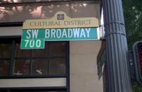
On this plan addresses are childs' play to augur in on. As you travel north or south on any street that would cross these, you just glance right or left to see how the addresses are running. A bit dry, perhaps; an address like 455 West 3530 South is mathematically exciting but literarily dull. But Portland's signage acts just like this. Check this blade fro SW Broadway near PSU that I snapped some time ago. The tab reads 700. SW Broadway is the 7th block west of the river in Downtown. The blade is telling you not that the block down the SW Broadway face is 700, but that you are either entering or leaving the 700 block of whatever cross street you're on. As in SLC, the crossing-street system assumes you don't need to be reminded what street you're on, but you do want to know how far up or down the street you're on without having to crane your neck left or right and hope to see the number as you go past.

If SW Broadway were a street in SLC, it would be South 700 West. 

I frame the concept thusly because it sets the stage for this next picture; the intersection of NE Pacific Street and NE Holladay Court.


The intersection of these two streets do not happen on an even address block point, and the new way of street-blading Portland attempts to address this. As someone who loves precision in such things, I'm kind of over the moon here. A bit of commentary perforce: in raw terms, the intersection of NE Pacific Street and NE Holladay Court is of two streets that are defined as east-west runners. They therefore have very similar blockface numbers. However! One has to remember that when you look at that block index, you're not looking at the the address on the street that is named but the address on the street you're already on that's defined by the point of the crossing street. Thus, NE Pacific Street cuts across NE Holladay Court at approximately 13050 NE Holladay Court; NE Holladay Court intersects NE Pacific Street at the address of 13020 NE Pacific Street.

If that weren't bewildering enough, this blade set might make you cross your eyes:


This is a few hundred feet back, where Holladay Street bends to become Holladay Court. Not exactly an intersection as one might think about it, until one thinks about it: it's an intersection, just one where a street name changes. Each block index reads 13000; this intersection is where the 13000 block begins and ends on either street.

It's a little challenging to get used to if you're a new Portlander; the only other Willamette Valley city I know that does it this way is McMinnville. Eventually, it'll click, and once it does, it'll seem like the most organic and natural thing … as long as you start with the idea that you already know what street you're on, and this tells you what's coming and going as you travel.

And the font? That's Clearview, baby. Looks good to me!

29 April 2009

I'm Not The Only One Talking About Portland's Street Signs ...

2045.Joseph Rose, The Oregonian's commute columnist, wrote a couple of articles not too long ago about the street signage in Portland, too long ago, not sure how I missed them, but I've stumbled on them, and they take on the oddities and drawbacks in Portland signage, and how it tends to fall short in many areas.

The two columns make very good points as well as at least one strange one, about which one crotchet presently. The first one makes reference to awkward and insufficient directional signage (which I quite assuredly agree with) and then stretches just a bit to draw out dramatic tension between the lacklustre street signage and Portland's progressive transportation reputation.

The strange point came with a quote from one Sharon Linnenkohl, a recent Angeleno transplant who has trouble finding things in town while she learns the lay of the land, and mentioned that "getting to Foster Road from I-205 southbound is a guessing game", which just seems odd to me. But before I seem to be rashing on Rose and Linnenkohl a bit too much, I will say that the overarching point is well-taken, and perhaps explains why we've been seeing a new street blade standard for Portland:

For starters, most of the street-name signs don't comply with new federal regulations adopted for America's aging population. The font on the signs is too small and their ability to reflect light at night is way beyond warranty.

Which is a esteemably fair call, once you get beyond the Federal regulations point. There are a lot of old and badly-reflective signs that need replacment and how, and the newer blades we've been seeing about fit that bill admirably.

The second one points out some more problems, noting one of the more famous critical points, the lower deck of the Marquam Bridge going south. Approaching this bridge and knowing that at the other end you have to go left to leave the stack to go downtown and stay right to go left out of that, is kind of counter-intutive.

There is a reason for it, however, and it has to do with the old Mount Hood Freeway (and now for a digression). The Mount Hood, as planned, was to merge into the lower deck's lanes from the left. Since that was the future designated route in for Interstate 84 (The Banfield was to simply be US 30) It was assumed that westbound traffic would prefer not to have to change lanes (so as to go straight downtown – The Mount Hood was planned for commuters, after all). It was therefore thought that the downtown leg stay on the right so as to reduce the number of lane changes. But the Mount Hood Freeway was never built, and there you go.

The second column continues in the vein of inadequate signage making it hard to find ones way around (and to) the bridges of the Rose City, amongst other things, and touches on the subject I've been obsessed on of late: street blades.

The old street blades are presumably being swapped over because they just aren't up to spec anymore and as the baby boom makes its way up the population pyramid, they're going to need to see where the hell it is they're going. The real payoff from that column, though, are numbers. They're pretty intimidating and intriguing:
  • There are 130,500 signs to maintain in PDX. These include ...
  • 40,000 street blades
  • 5,500 guide signs
  • 10,000 "yellow school" signs
  • 14,000 STOP signs
  • 12,000 Warning signs
  • 49,000 parking signs
  • The annual budget for the sign shop is $702,000, which covers missing and vandalized signs and not much else, apparently
  • The signs are produced in a sign shop that has 1 (one) employee
  • Each new street blade costs $22 to make
  • The real problem is finding hands to put up the signs. Funds are at a bare-bones level, though, so they have to apparently wait for a break in work crew business to erect them.
It looks like a case of doing the best they have with what they got.

But at least now we do have some idea of why the new street blades are going up. And they are more readable, that's obvious (as I think I'm documenting very aptly here).

In Matters Related, Red Electric blogger Rick Seifert posted a couple of times about a sign imbroglio in his Southwest neighborhood. Anyone travelling down Southwest Barbur Blvd from downtown Portland knows about that hard little turn you need to make to get off Barbur going southbound to get to Southwest Capitol Highway to get to the Hillsdale business district and beyond to Southwest Beaverton Hillsdale Highway. It's a very tight corner, but it's at least got a rather adequate sign.

ODOT decided to place a bike warning sign at that intersection, which is a wise thing to do. But why, one wonders, did they put it right in front of the Capitol Hwy/Hillsdale guide sign. Couldn't they step back and say "ahh ... won't work"? Seriously – this really did make the guide sign pointless, and also partially obscured the directional sign to OHSU.

After lodging a complaint with Those Who Must Do Something, the sign was moved, and you can see the Hillsdale/Capitol Hwy guide again ... but the TriMet bus stop sign still obscures the big blue-n-white H.

And so it goes.

Technorati Tags: , , , ,

22 April 2009

SE 82nd And Washington, Tuesday, 8 PM

2040.The sign of the Chinese Village restaurant, SE 82nd and Washington, doesn't get any respect in any classic neon inventories of the Portland area. But that doesn't mean it's just as charming:


If you'll remember the timeless quality of that sunset on Tuesday evening, I'm sure you'lll agree. It seemed to go on forever. If you don't agree with me ... well, why you got to be so mean?

The sign top along 82nd by many of the signs reads 82nd Avenue of Roses:


It's a bid to raise the profile of 82nd Avenue which, by many accounts, might pass as distressed. It doesn't bother me much. You see a different level of life on 82nd Avenue and it looks a little threadbare in places, but, judging by the ruin latterly practiced in Portland under the rubric of "urban renewal", maybe it's better off the way it is.

There are lovely places alone 82nd; there are shabby places along 82nd. Sure it would be nice ever everything were lovely and dear and pleasing, but life isn't that way: there are sweet spots and ugly spots. Why are we afraid that the world around us reflect the life that we live?

Sure there are things about 82nd Avenue that need attention; the prostitution traffic along that arterial comes to mind. But for every shabby car lot there's a rehabilitated restaurant; for every tired-looking Safeway store there's a pleasant view of Mount Tabor.

But then, I've always looked up at life from lower levels. Maybe that's why it does't faze me too much.

Technorati Tags: , , , , , ,

21 April 2009

Blade Rewrite Achieved: SE 148th and Stark

2038.It may be remembered that, back here a bit, I scouted a rogue NE avenue blade that had somehow wandered into the SE:


While we were on blade patrol today we went by that corner and found out that the rewrite that we had called for had occurred. The blade now reads SE 148th Av. Despite its closeness we were unable to go by NE 148th and Glisan to see if that had been fixed but we presume it had.

We don't know if writing about this blogwise caused the rewrite or some sharp eye in the neighbohood. Either way, good work City of Portland, and we thank you for taking the trouble to correct! Much obliged!

Technorati Tags: , , , , , ,

SW 57th and Barnes Rd: New Blades In The Woods

2037.Out on new street-blade patrol today, inspired by a tip from Isaac Laquedem who mentioned there's a new blade set at SW Barnes Rd and 57th Avenue (thanks, Isaac!)

This area, in the section of the city we call Sylvan, is a curious one in geographic terms. Portland grew to the east, mostly, and the flatter part, the part it's easier to draw straight streets over, is there, and you'll find vastly more continued streets. But there are extended streets in the West Hills, you just have to go looking for them. I'd wanted to do that for some time.

To get to SW Barnes and 57th, just find your best route to SW Skyline Blvd and go west on Barnes, which is the first cross street south of West Burnside Road. The KOIN transmitters are up there too, since Sylvan Hill is a traditional area for placing of radio and TV transmission towers, so if you follow the big masts, you'll get there too. A very short jaunt west on Barnes from Skyline will bring you to SW 57th Avenue.

The sign is there to the right. Below you'll find a few tighter shots.

This is the Avenue blade:


And here's the Street (Barnes Road) blade:


What's that now? There's no block index here. I wonder why? I have a feeling they're still trying to get the bugs out, or they just want to see these blades up; they seem to be going up rather more quickly than I'd of assumed they'd be; but there it is.

For what it's worth, if the sign did have a block index, it would be 800 at this point; SW Barnes Rd cuts SW 57th Avenue at the 800s. There's a single house between there and the next street south with a three-digit address beginning with 8, and the next block down is SW Taylor Street, which is the 900 block west of the river.

And that's why I mentioned streets being extended westward. It's an interesting thing to my Address Nerd ears to hear "Southwest 57th and Taylor", since streets are so sparse in that area. But when The Great Renaming happened, one of the tenets was a street name should be extended across the city wherever logical, and, presumably, if Taylor had been built up unbroken from downtown over the hills, it would cut through here (or near enough as makes little difference).

Speaking of new blades, the SW 57th Avenue sign at Taylor Street sign would need rather a bit of help, I think:


The setting of SW 57th Avenue going south from Taylor and Barnes is quite a pleasant place, actually:


If I wasn't already familiar with the diversity of Portland's geography, I wouldn't believe this were within city limits.

Technorati Tags: , , , , ,

05 April 2009

New Street Sign Moves NW Marshall St Two Blocks North – Get Us Rewrite #2!

2013.Fresh from the blog Sellwood Street, I see proprietor John D has also been on the new-blade lookout. He's found us a gem:


Photo copyright John D of the blog Sellwood Street
(sellwoodstreet.blogspot.com), used for illustration
purposes only. Creator retains all rights.

That looks pretty good! The new form is still consistently followed. That's not all; this is the first instance of the new blades I can recall being on a non-arterial (you can argue that nearly every street in NW Portland is a main street, but it's not one of the through routes I'd recommend to get through the area). All other examples found so far are either on arterials (such as SE Division Street) or main routes through neigborhoods (SE 92nd Avenue).

But, just as our blade at SE 75th and Division has, there's a small problem with that one too. Coincidentally, it's the same one: The block index is wrong. John D nails it as to why, but succinctly, while M (this is PDX's own Alphabet City, remember) is the 13th letter of the alphabet, Marshall Street is not 13 blocks north of Burnside, it's 11. Since the first block (Burnside to Couch) is for addresses between 1 and 99, that makes Couch 100, and counting north, NW Marshall Street is the 1100 block, not the 1300 block.

John asks:

You makin' a list ZehnKatzen?

Maybe I should. Someone ought to!

(mad props to John D and Sellwood Street)

Technorati Tags: , , , , , , , ,

31 March 2009

New Street Blade at 75th And SE Division - But We Need Rewrite!

2002.Spotted another new street blade, this time at SE 75th and Division:


It was notable for being one of the half-and-half assemblies (half-old, half-new ...  The Wife™ calls them "hybrids") with the old one atop the new one. As such, it's not worth getting too excited about – certainly not worth going back and getting another look at right away, except for one thing. And if you've got a sharp eye, you've probably already seen it. Here it is up close:


That's right – the block index, which should be on the named blade, is on the numbered one. There's a couple of incorrectitudes here; it suffers from the general assumption that SE Division Street is the 2500 block along its entire urban length (it isn't; from SE 42nd to SE 82nd Avenues it jogs a block north, and becomes the 2400 block) and as this is actually on the north side of Division, if indicating the block face were the intent here, that ought 2300, not 2500.

In as much as all of the new blades up until now have supported the old convention of displaying the crossing-block, we are compelled to assume that this is a bit of an error, and plaintively call for rewrite as I did for those blades out alone NE and SE 148th Avenue.

The documentation is ongoing.

Technorati Tags: , ,

25 March 2009

New-PDX-StreetBladePalooza and More Curbstone History In Sellwood

1995.Today I found not one but two new-look PDX street blades. We go into Sellwood with gun and camera ... minus the gun.

This is a view down SE Tacoma Street looking toward the 13th Avenue light. That spire on the right is a Columbia Sportswear store that at one time, not too long ago, was the Sellwood Theater movie house:


A thing to see in the area is the sign to the Methodist Church, there on the left, which typically has Korean (well, at least it looks Hangul) on the readerboard. Very interesting to view.

And, askew on the SE corner of SE 13th Avenue and Tacoma Street, The Wife™'s sharp eye picked out this:


Tacoma Street is the 81st full block south of Burnside, so Tacoma equals the 8100 block.

The signs are looking better and better. The block index, which seemed to crowd the name at first, now seems more natural that way. Here's a closer look:


And the Avenue blade:


The kerning on this sign is very well done. There's a companion for it, over on the NW corner of the intersection, adjacent to the dental clinic (which, I note, is accepting new customers).

Some time ago I had a "day job" down in little ol' Sellwood, and decided to leave the area on a circuitous route, doubling back on SE 17th Avenue to go either north out that street or east out SE Tacoma. Little did I know that Sherrett Street had a surprise for me. Here you go:


It's a longer name, there's a longer blade, and the block index number is a little condensed (the numbers themselves seem a little bit squeezed skinny). Note also here it's a mixed set; like the 92nd and Ellis assembly I showed off a little while back, the SE 17th Avenue blade is the old-look, extruded style. The new Sherrett Street blade is only on the NE corner of the intersection; it's companion, on the SW corner, is the traditional old-style (complete with bolted-on block index tab on the Sherrett blade), is pretty weathered and could use replacing itself.


I remember when I worked in this area, about two-three blocks south of here. If I didn't know it before, I'd not recognize it now; something is always being built or remodeled around there these days:


That convenience store there on the right, Foster's Market and Deli, has been there an awful long time, and if it's still owned by the Fosters, under the same ownership.

Nice, dark photos, yes? When you've lived in a place all your life, you tend to take the environment for granted, including the seemingly-everpresent Oregon overcast. It's not till you get the photo home that you realize how dark it was out there. You'd think I was shooting day-for-night here.

One other remarkable thing. My obsession with the Portland address grid should by now be a matter of wide public record. I've also documented that frequently the archaic street name was preserved in the curbstone of the corner; I don't know exactly why they decided to do that, though I've always thought that it was for the benefit of pedestrians (of which there were undoubtedly more of back before 1930). But the point I'm driving at is that when the city street grid was rationalized in The Great Renaming of 1933, some numbered avenues actually changed thier names too. In a posting made on 23 Nov 2005, I published some pictures and findings detailing the changes that occurred over time at the corner of SE 53rd Avenue and Woodstock Blvd (which were once known as, respectively, 54th Street SE and 60th Avenue SE).

The corner of SE 17th Avenue and Sherrett Street has a similar treat in store. The corner holds the name of the contractor who poured the cement and dates it to 1910, twenty years after the merger of Portland, East Portland and Albina into the kernel of the modern-day City of Portland and twenty-three years before The Great Renaming. Looking down at the corner side facing onto SE 17th Avenue, one finds the following:


It may be a little hard to read at that resolution, but it says:

E. 19 ST. S

In 1910, what we call SE 17th Avenue was known to the people who lived in Sellwood rather as East 19th Street South. The suffixing of South is unexepected, as the general Portland street naming scheme of the day suggests it would have merely been East 19th Street only. Perhaps the suffixing of South was reserved for streets in the city's outer areas, as Sellwood is today, and with the slower travelling modes of the dawn of the 20th Century, would have seemed like the boonies.

But how did 19th Street move down two places to become 17th Avenue? We can only guess that they started counting from a slightly different place, or decided to call 15th 17th for some reason. But some number changing went along with the name changing.

Technorati Tags: , , , , , , , ,

18 March 2009

New Style Street Blades Sighted At SE 92nd And Ellis

1984.At last! The first example of the new-look City of Portland street blades has been sighted off SE Division Street–just outside of downtown Lents, at SE 92nd and Ellis.

Coming in from the north on SE 92nd Avenue–our destination being the Oriental Food Value market on SE Insley just east of SE 82nd, and at that time of the day, coming in the "back" way rather than down 82nd is just the smarter thing to do–the SE Ellis Street blade presented itself with a visual shout, which is probably why they settled on this design:


Notable here is the way the new street blade for Ellis was perched atop an old street blade for SE 92nd Avenue (note that it's the extruded blade, and not a sheet, as the new design is).

I was somewhat disappointed that there was no new 92nd Avenue blade until The Wife™ pointed across the intersection, on the Lents Little League field side of the street:


The visual difference is obvious. These blades are so easy to spot and find, which is proved every time we find a new one like this.

Here's the money shot:


It's interesting to see a new named-street blade that doesn't say "SE Division St", for now we have some idea of how the rest of the city will look once these blades are the standard.

And here's a shot of the new-look cross including the 92nd Avenue blade:


And the documentation continues. If anyone who passes this way by these humble blog missives and lives in Portland (obvious point, yes) sees these new-look blades anywhere else in town, won't you clue me in? I'd like to get some idea of how far these are going.

Technorati Tags: , , , , ,