
 I give you street signs, another fascination of my early days. People who actually erect these signs call those signs that identify the streets blades, and so will I, from here on out.
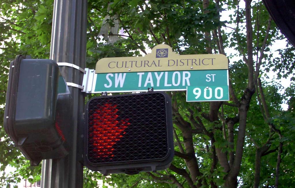
This photo of the SW Taylor Street sign (as it happens, at SW Broadway), amply illustrates the basic format for all street blades within the Portland city limits (ignoring the obvious attachments). Green, with bold letters for indentification, and the directional and name (SW TAYLOR) much larger than the street type, which is still centered for ease of readability (the eye follows the type from the large type to the small without extra effort). Since, in nearly every area of Portland, numbered avenues cross named streets, it's not necessary to quickly register that Taylor is a Street.
The basic format gives only basic information, however. To this end, the city sanctions a couple of attactments. The first and (so far as I'm concerned) most important, is the addition of a block-number tab to the basic sign. The one on this is "900" which, as I've before intimated, does not inidicate the 900 block of SW Taylor Street, but the 900 block of SW Broadway. Whether you are entering or leaving that block depends on the direction you're traveling–since SW Broadway is a one way street going south, if you're looking at this sign from a moving vehicle, you're entering the 900s. Or you better be. You'll get a big surprise...soon...if you're going north.
Have the block number on the sign is an important device; if one is unsure where they are but knows the city well enough, on main streets, all you need to do is glance at the sign, not inspect buildings along the street for addresses whose appearance cannot always be counted on. In neighborhoods away from main streets these tabs are usually not mounted; presumably by that time you're driving slowly enough that you can eyeball the address on the buildings.
(Quick parenthetical rule of thumb for downtown: Odd numbered Avenues are one-way southbound, even numbered avenues are one-way northbound. Count SW Broadway as 7th)
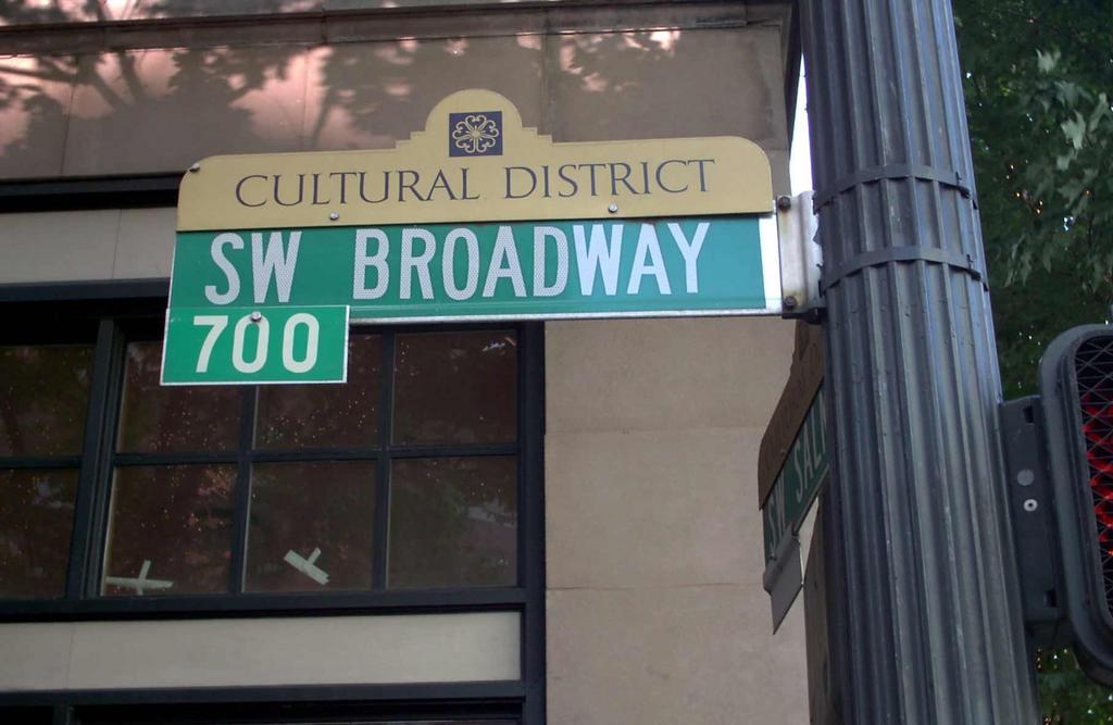 The other attachment is what I call a sign-topper. This is a fashion that has really caught on of late, which is designed to give identity-starved neighborhoods some sort of cohesion somehow, or at least some sense of neighborhood pride or brand-identity. I am of a mixed mind about these. Some of them are quite good, a couple are brilliant, many of them are bad. I plan on exploring this topic in the near future. A big minus is that they tend to displace the block number tab from its proper place (which is typically centered on the top blade), or makes it gone entirely.
Take a look at the blade for SW Broadway on the left there. The area of south downtown (call it south of about SW Salmon Street, and west from SW Broadway to the Stadium Freeway (I-405)) has been styled the "Cultural District"; Schnitzer Hall, Portland Center for the Performing Arts, Portland Art Museum, Oregon Historical Society, and Portland State University all are situate in this area. When attempting to communicate a perception of sophistication that would perforce pertain, an understated gold backs up a classical typeface. Good so far, but the reference to the patterned tile in the top center is rather unclear. It may be drawn from local architecture, but it's hard to say just what.
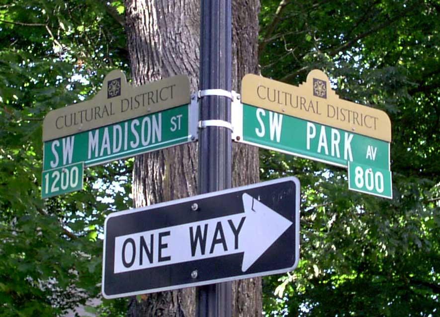 The last picture I'd like to share for now is a picture of the sign at the corner of SW Madison Street and Park Avenue. Numbered Avenues don't need block number tabs-since the hundred-block of the numbered Avenue begins with the number of that Avenue (18th Avenue defines the 1800s on the cross street)-they don't need them. When a named Street crosses a named Avenue, they have to get creative. Usually, though, this just means that the blade on the bottom has the tab displaced to one side or the other of the signpost, and usually hanging from the bottom edge. But when you have sign-toppers on the job, all tabs–if they're there–go to the bottom. Here we see the 800 block of SW Madison Street and the 1200 Block of SW Park Avenue.
Speaking of SW Park Avenue and SW Broadway, there's a couple of issues I like to touch on. Noticing the SW Broadway blade, notice how there isn't a street type on it? It's not "SW Broadway Avenue" (which would be thematically appropriate), but just "SW Broadway". That's a quirk about Portland that I've always been fond of. Moreover, down through the years, streets in town that are called "Way" have had that folded into the street name leaving the street typeless: NW Wardway, SE Reedway. Sadly, it does seem to be subject to slow replacement; I've seen "NE Broadway Street" replace "NE Broadway" and "SE Reedway Street" replace "SE Reedway". I lament this. It's a cute local quirk, and I think well enough should be left alone.
With respect to SW Park Avenue, there's a name change on part of it. North of the Arlington Club/Paramount Hotel block (about SW Salmon Street) the street's character changes. South of Burnside, SW Park Avenue and SW 9th Avenue define a very narrow east-west block, a legacy from Portland's early days, when that strip was a wide-open area called "The Boulevard". In the areas that were commerically developed, the streets carry the names just mentioned, but once south of Salmon and the Park Blocks take up, both streets carry the name "SW Park Avenue"...leaving the name "SW 9th Avenue" behind.
4 comments:
Isaac Laquedem:
My theory is that this is to avoid confusion: if both were "SW Park" then each would have east (even) and west (odd) addresses, and different buildings could have the same address.
I think that you are spot-on with your analysis. South of the Arlington Club, the street is more like a very wide road with a huge median than two separate streets.
Back in the day, when paving was still several years out, historians say, there used to be horsecart races down The Boulevard. Wouldn't that've been something to see?
Again, Isaac:
Here and there the City messed up and let people dedicate east-west Places and north-south Courts
I suppose there's exceptions to every rule. Thank you for pointing that out, after all my gazing at Portland maps I never registered this.
You continued into the next comment:
What other Portland-area streets don't have the traditional endings?
You gave quite a few good examples. You left out one, though: SW Fairview Circus. It's listed on most maps as "SW Fairview Cir" (it comes off SW Fairview Blvd north of Washington Park) so this no doubt gets missed by many.
PortlandMaps.com confirms this street.
I'm font of streets you mentioned, eg SW Market Street Drive, too. They look interesting on street blades and they just seem so ambivalent (which am I gonna be...street or drive...oh, I'll just be both! Win Win!). With respect to SW Ford Street Drive, you've no doubt noticed that there seems to be no SW Ford Street. I believe it once existed, or was at least dedicated, but was either never built or eliminated somehow.
As for as "SW Upper Hall Street" goes, I think of it as a street-just the upper part of one, which got airs. Appropriate, since it's up in Portland Heights. Beautiful views. Scary street to drive, though.
as an outsider, there are two unusual thing that one notices (1) you have five quadrants and (2) usually cities with a quadrant system put the quadrant after the street name (1000 H Street NW not 1000 NW H Street)
ps -- I lived for a year in Cedar Rapids IA -- if you go north from its NW quadrant you are in the NE quadrant, I could never get used to that
Jim:
as an outsider, there are two unusual thing that one notices (1) you have five quadrants and (2) usually cities with a quadrant system put the quadrant after the street name (1000 H Street NW not 1000 NW H Street)
I don't know If I've mentioned, but I've collected hundreds of city maps from all over the nation (and even the world). It very much looks to me like that is kind of a regional style.
When calling the directional areas 'quadrants', I'm continuing something of a custom hereabouts. True, it's inexact, but I think of it this way: The compass has 12 quarters, so 5 quadrants in this wise should be ok.
Many cities in the Plains, when they do things this way, do tend to suffix thier directionals. The easternmost city I've been able to find that does this (besides Washington DC) is Canton, Ohio. It's a quadranted duplex directional, NW/NE/SW/SE, divided along Tuscarawas St E/W and Market Avenue N/S. Grand Rapids MI also springs to mind.
A notable exception that I have is Des Moines IA, which uses prefixes for directionals, but only on the numbered streets, and tends to mix up the simplex/duplex directionals. It requires a bit more explaination than a simple reply would allow for.
As far as a local style for the Pacific Northwest, it varies. Many cities prefix (Portland, Corvallis, Pendleton, Ontario), others suffix (Salem, Albany), and Seatlle mixes it up: E-W are Streets and are prefixed, N-S are Avenues and are Suffixed. Also, due to the way Seattle grew out from the center, there are not four or five, but ten different directional zones (some have no directional at all). Dial yourself up a map of Seattle if you can; it's quite an interesting city to see on a map.
Jim, again:
ps -- I lived for a year in Cedar Rapids IA -- if you go north from its NW quadrant you are in the NE quadrant, I could never get used to that
Yes. I have a map of Cedar Rapids, precisely because it has such a fascinating plan. And I know the reason that you can go north from NE and end of in NW because the dividing line-the Cedar River-flows NW to SE. Moreover, the dividing baseline street (Andrews Avenue, if memory serves), doesn't straighten out cardinal E-W when East of the Cedar but curves to be going N-S, all the streets in NE bending to follow but all the streets in SE becoming cardinal.
But the coolest thing is the City Hall located on an island in in the river. I assume the bridges leading there are drawbridges because the peasants are, well, probably revolting.
Isaac:
Brilliant followup; first class detective work. This follow gets its own post!
Post a Comment