
 Dig, if you will, this picture.
A few entries back, we reviewed another portion of the secret division street of the west, West Stark Street, this a particularly charming partiall-developed part off Miller Road at the Washington/Multnomah frontier.
This sign you're looking at is about a mile west of that location (directly west as, remember, we are on the selfsame surveyed line) at the intersection of NW/SW 90th Avenue–as the highly interesting sign will attest.
This segment of 90th Avenue is actually logically part of Leahy Road, which is a collector road which zigzags from SW Barnes Road at about the 8600 block to NW Cornell Road at about the 11000 block. It's an essential connector between the two lateral roads and the only one available between Skyline Boulevard and Cedar Hills Boulvard, and serves as a convenienct divider between the Sylvan area and the St Vincents Hospital area.
At one time, the whole road was called Leahy, but as development occurred and the Portland Address Metagrid was extended through the area, it was presumably found that the discontinuity, north to south, of this section of the road was too much of a distance...or, as Isaac Laquedem said aptly:
Leahy Road is an interesting case. It's fairly easy to figure out where the spiritual Leahy Road is. It starts at Barnes and runs north, west, north, west, north, west, and north to Cornell. At some point (I think about 30 years ago) the long north-south runs were renumbered to be SW/NW 90th Avenue and NW 107th Avenue. I'm guessing the fire department was behind the change: the houses on Leahy are numbered as if it's an east-west street, and the north-south runs are inconveniently long to squeeze in non-conflicting house numbers.His definition of the situation is as good as any I've known, so we'll go with that.
The neighborhood running up and down the nearly ten continuous blocks of West Stark that center on this 90th Avenue cross area are suburban in character, not too unlike the area of Baja Gresham in which I live (think Greater Mall 205 with substantially increased property values). The biggest difference is that it's on the side of a hill, and it's obvious. The top of the hill, about the 8500 block, is apparently at the very western edge of the wooded lot that the previous piece of West Stark devolves into (see the photo in this posting; the bright spot in the destance is the top of the hill in the view on the left of the picture below)...
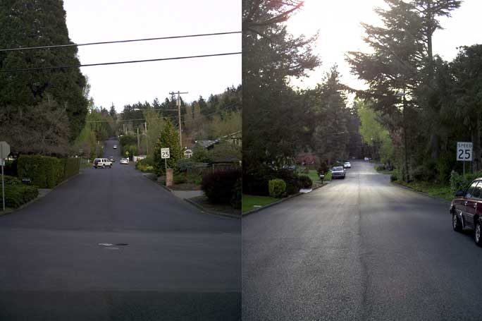 West Stark Street at 90th Ave/Leahy Road looking uphill/east (left) and downhill/west (right)(click to see it bigly)
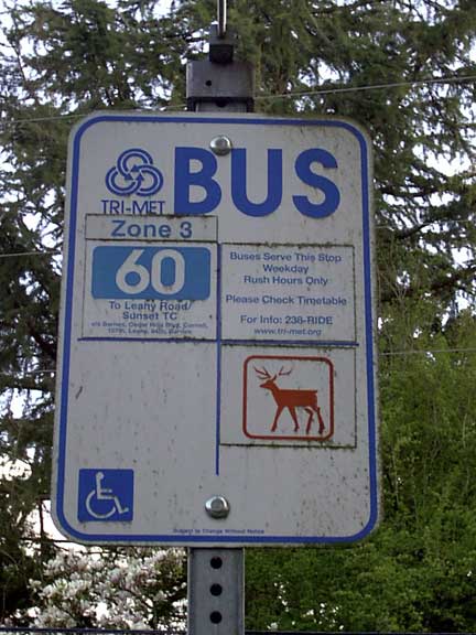
The TriMet bus stop sign (this street has the line 60-Leahy Road running along it) is actually a period piece that gets rarer and rarer by the day. It was the standard design during the period before TriMet redesigned its look about two years ago and details some features which dateit handily:
- The route numbers, which appear to be some form of Futura, against a blue rectangle with rounded corners.
- The field of the sign divided in four parts. Each part could contain another route marker, a standardized sticker containing either coverage information or a small zone schematic diagram, a sector symbol sticker, or contact information. The TriMet sector symbols have been reduced to afterthoughts in the new design, now only seen on the downtown Transit Mall shelter signs. This area of central-west Portland Metro, going into Washington County, was known as "Orange Deer".
- The sticker Zone 3 was of a standard form and in a standard place.
No comments:
Post a Comment