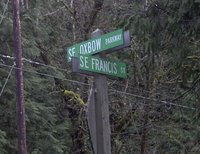
 Dig, if you will, this picture. Also, if y'all'd be so kind, please get out the Guide of Thomas, and open it to page 630, and turn your attention to grid E3.
You there? Good.
One of the interesting things of streets in Greater Portland is that you'll find extensions of streets that emanate from the main part of Portland, whose structure sets the address and street pattern for the greater part of the three counties of Multnomah, Washington, and Clackamas. This picture depicts what I think is the farthest reach of any street from its base: SE Francis Street at about the 34600 block. You get there by going out to Oxbow Park; follow the signs all the way out past Gresham on SE (then NW, then NE, then SE again but it's a "Drive" after that) Division Street.
It's a beautiful wooded area, going down into a dale, and it feels like its about a million miles away from anywhere else (just like the prices on the sumptuous houses in the area...but I digress). It may indeed be possible that the street should just so happen to have that name, but a rather detailed examination of the maps in my collection shows that this bit of road very nearly lines up with the parts within the Portland corprorate demesne, or near enough that any other alignment would result in a similar name. Also the addresses of what few houses were in that area on Oxbow Parkway (a n-s street) were in the 3800-3900 range, which corresponds to where Francis crosses inside the city.
As far as I can see, this is the one street name which extends farthest out from the Portland base than any other (nearest other I can find is SW Vermont Street west of SW 209th Avenue in Washington County–check it out–this lines up even better than this does).
And what kind of landscape does one find out there? Tranquil. Almost fit for a Bob Ross painting:


No comments:
Post a Comment