
2240.Fellow street sign blogger Eric Fischer, whose San Francisco work I've praised, has done me a definite solid and dropped a very beautiful thing my way.
As I may have alluded to in another post somewhere, Portland's street blades have looked different. From, I'd estmate, around 1900 through the middle third of the 20th Century, PDX Street blades where these indesctructable iron things, with white and enamel paint, which looked like this:
As you can see, it's very utilitarian. Blocky, almost-military letterforms – not graceful, but very very readable.
In a recent comment to the Cyclotram's P13 Stark Street Milestone, fellow street sign blogger from San Francisco (whose work I enjoy) Eric Fischer pointed me to a most amazing publication, in the public domain and available in its entirety on Google Books. It was in this book, Municpal Engineering Practice, by A. Prescott Folwell and published in 1916 by Wiley and Sons (a book generally about designing and laying out cities), that I found the following view – the inside of Portland's sign shop, ca. 1915 or so:

http://books.google.com/books?id=7AJLAAAAMAAJ&dq=%22street%20name%20signs%22&pg=PA295#v=onepage&q=%22street%20name%20signs%22&f=false
Technorati Tags: sign design, street sign design, vintage PDX, PDX Geography, PDX Street Blades, Portland Oregon, Portland history
As I may have alluded to in another post somewhere, Portland's street blades have looked different. From, I'd estmate, around 1900 through the middle third of the 20th Century, PDX Street blades where these indesctructable iron things, with white and enamel paint, which looked like this:
As you can see, it's very utilitarian. Blocky, almost-military letterforms – not graceful, but very very readable.
In a recent comment to the Cyclotram's P13 Stark Street Milestone, fellow street sign blogger from San Francisco (whose work I enjoy) Eric Fischer pointed me to a most amazing publication, in the public domain and available in its entirety on Google Books. It was in this book, Municpal Engineering Practice, by A. Prescott Folwell and published in 1916 by Wiley and Sons (a book generally about designing and laying out cities), that I found the following view – the inside of Portland's sign shop, ca. 1915 or so:
You have to embiggen this to see it in its full glory, to do this, go to Posterous here and click on the photo (which you can also download) or click on the photo above.
Lined up along the bottom there are signs for E. 70th ST. N (today's NE 70th Avenue), E. 72nd ST. N., 50th AVE. SE (today's SE Raymond Street), and 41st AVE SE (today's SE Gladstone Street). I also see a rather big blade, reading (on two lines) PATTON ROAD/COUNTY ROAD, and there are signs for CRYSTAL SPRINGS BLVD, WISTARIA AVE, and possibly a deprecated style for WASHINGTON ST.
To go over it real quick again, before the Great Renaming of 1933, numbered streets east of the Willamette and north of Burnside not only carried the East prefix because of that but also the North suffix to extend west-side naming practice east in a uniform way; therefore 11th Street east of the Willamette and north of Burnside would be EAST 11TH STREET NORTH. The avenues suffixed SE were in the area south of Powell and east of E. 39th Avenue which, for reasons even not yet clear, had number congruent to today's street blocks going out in both directions, though avenues ran east-west and streets north-south: therefore, 1916's 50th Avenue SE would be today's SE Raymond Street, which is the 5000 block (50th standard street name south of East Burnside) and 41st Avenue SE would be SE Gladstone Street – today's 4100 block (41st standard street name south of East Burnside).
The viewer can no doubt find some things that I've missed, and it's all interesting and good.
Thanks Eric … you definitely da man!
To view the page directly and download your own PDF of this book, surf to the following:
http://books.google.com/books?id=7AJLAAAAMAAJ&dq=%22street%20name%20signs%22&pg=PA295#v=onepage&q=%22street%20name%20signs%22&f=false
Technorati Tags: sign design, street sign design, vintage PDX, PDX Geography, PDX Street Blades, Portland Oregon, Portland history
8 comments:
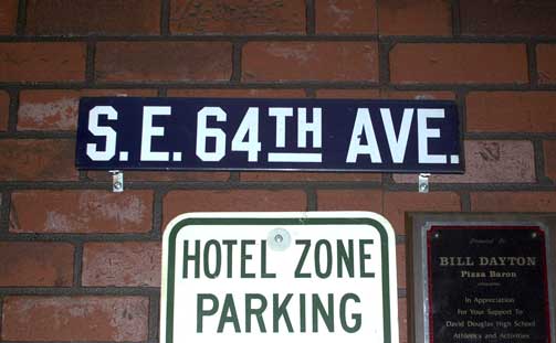
Excellent! The blue one at the top caught my eye especially since I lived on SE 64th for about five years.
Where is that sign?
That sign can be seen on the wall of the Pizza Baron, in that shabby little strip center on the southeast corner of SE 122nd and Division, behind the All That Glitters pawnshop.
Tasty pizza, a Shakeys-esque ambiance (complete with the big rough-hewn tables) and a salad bar. You'll think it's 1987 all over again in that place. And one wall full of these amazing vintage signs, of which the one for SE 64th Avenue is merely one.
Awesome. I've just written a story for Crosscut.com on Seattle's new blades, BTW -- it's not up yet, but I'll let you know when it is, as I linked to you in it! As far as I can tell there's only one pre-1960s blade left out in the open in Seattle.. I'm surprised even that one survived.
Nifty, Ben … I'll be looking forward to that with great interest, sincerely … especially since you've said you'll be linking to me, which is highly skookum of you, of course.
If the Patton Road / County Road sign is in fact one sign with two lines on it (it looks that way), could the squiggle after "County Road" be an arrow? Patton Road is in southwest Portland, but until the 1950s the city limits ended at about where Patton intersects Talbot and Humphrey. Maybe that sign was intended to go where Patton Road went from being a city street to being a county road.
Isaac: I very much expect that the squiggle is an arrow and what you just said what actually what I was thinking about that sign. The edge of Portland was much, much closer in in 1906, I expect, even more so than it wa in the 1950s, maybe, perhaps, I'm not sure.
One thing I've always dreamed of doing was a sequence of maps detailing the territorial growth of Portland. Maybe now is the time to get serious about that sort of thing.
Here's the Crosscut article, by the way.
Ben:
Nicely done article, very nicely done. Thanks for the link.
I identify with each one of your thoughts, pretty much, which should be of no suprise to you.
Post a Comment