Showing posts with label West Burnside. Show all posts

06 July 2024

What Kind of Burnside Bridge Do You Want For The Future?

4161While the process grinds forward on the redux of Interstate Bridge 2.0, the process is rolling along quite smoothly on the planning to replace the Burnside Bridge.

The current bridge is gorgeous, laden with history, a classic of design, a linchpin of Portland's geography, and will collapse like a Republican excuse for not doing the right thing when Cascadia Next happens. It's apparently advantageously situate for keeping the city together in the wake of that anticipated cataclysm, so the goal is to have a Burnside Bridge that will not shake down when that 'quake finally happens.

In the apres-quake times, the most important thing for getting Portland back on its bearings ... however long that will take ... will be eastside-westside connectivity and access.

The opporunity is being taken to make the new-Burnside-Bridge-to-be another example of statement architecture that we Portlanders are so very fond of. There are two options to consider; a tied-arch bridge, similar to the Fremont Bridge, and an cable-stayed bridge, using the technique that was built into the Tilikum Crossing. 

These two styles are asymmetrical; the signature architectural part, the arch in the first case and the cable-stay tower support in the second, will be over the Interstate 5-east end of the bridge, leaving a span over the middle of the channel for a the necessary drawspan for river traffic and for making Portland tourist wonder why they had to stop on the bridge in the middle of the day.

There are also variations on each style. This picture, sharked from the Earthquake Ready Burnside site, shows the beauty profile of the tied arch look from a point in Tom McCall Waterfront Park on the west bank:

Source: https://burnsidebridge.participate.online/tied-arch.html

Driving over it will look like this ... which reminds me of a crossing of the Fremont, which has always been a love of ours:

Source: https://burnsidebridge.participate.online/tied-arch.html

The other option, the cable-stayed version, looks this way:
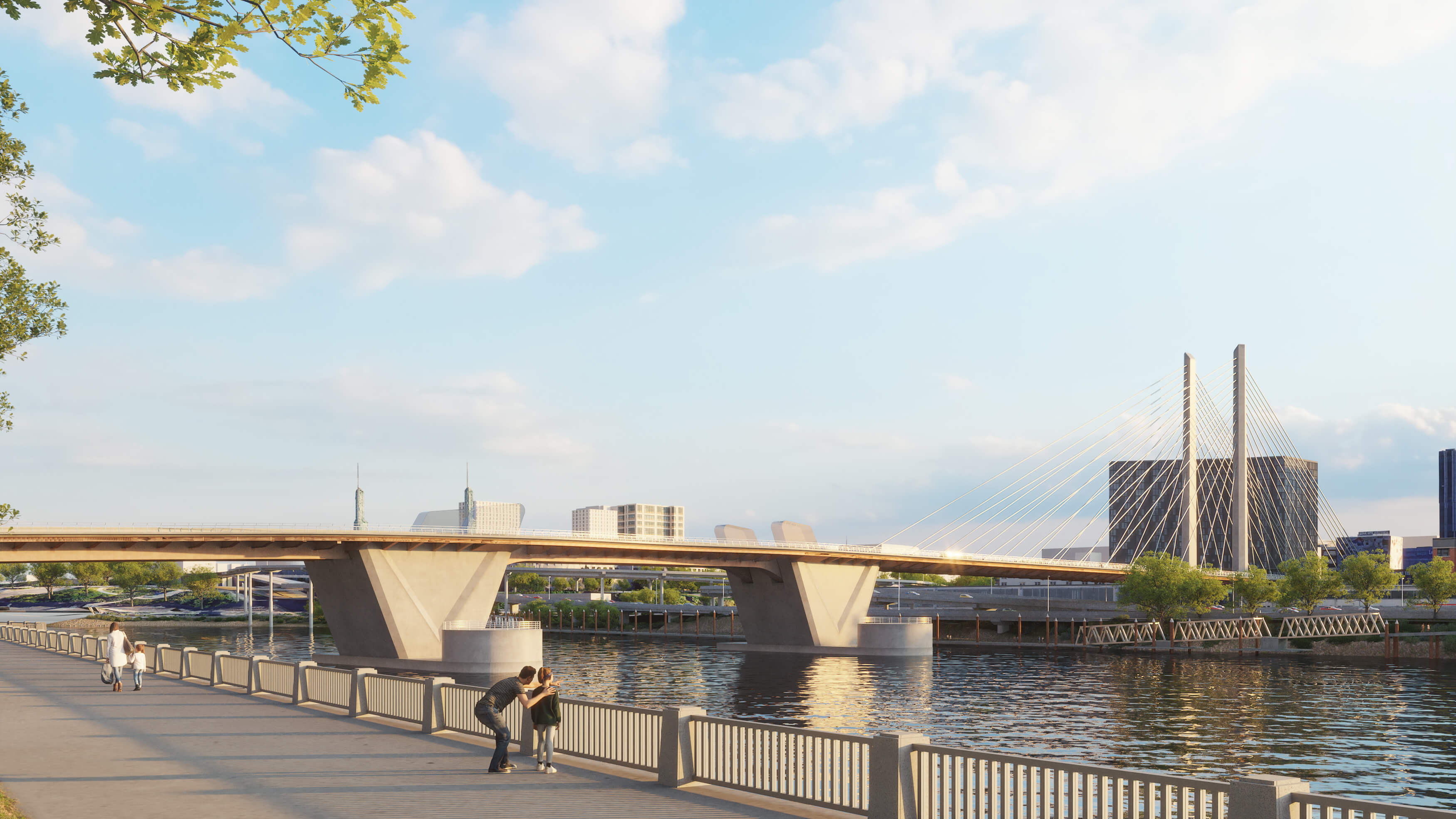
Source: https://burnsidebridge.participate.online/cable-stay.html

This version will have taller towers than the arch-style, but the visual presence isn't there for me. However, the asymmetry of the cable stays does have a element of dynamic style in it.

There is a survey on line that anyone can submit their opinions and personal preferences into, it's found at https://burnsidebridge.participate.online/survey.html. The homepage of the informational website is https://burnsidebridge.participate.online/, of course. 

In the near future, this bridge will close for a remarkably-long five year span for this replacement. I don't even remember the Hawthorne Bridge being closed for that long back in the 90s when they updated the eastside approaches.This will be something to contend with for a lot of us on all levels. I'll be recording everything I can about it and posting it here as I go.

We were there for the opening of the 21st Century Sellwood Bridge, and I'll put my anchor down here; I'm looking forward for us to be there for the opening of the 21st Century Burnside Bridge as well. In the meantime I'm going to be finding us taking many more pictures of the current span; it's a charming architectural gem, and that passing will be notable. 

06 October 2021

It Rises Over Tenth Avenue

4014

You have no doubt heard of the Ritz Carlton being built on the block bounded by SW Washington and Alder Streets, and SW 9th and 10th Avenues. We drove past it on our way to Powells, and before we left, I took some pictures of the ziggurat in process.

It's not dreadful, I guess. It doesn't exactly move me to excitement, though.


This is what you might see if you stand on the corner of NW 10th and W Burnside and look south. One more tall building that we couldn't really afford to patronise and wouldn't if we could. Gentrification of a place is a thing of whiteness in more than one way; it's driven by white people's money, white people's values of luxury and success, and it turns a place with interesting color just as bland as dreadfully boring as it can be.

So, it's there, and it's being built, and it replaced a famous block full of famous Portland food carts, and I guess it is what it is.

The blanding of Portland continues.

26 June 2021

Murals Over Harvey Milk Street, Part Two

3953

To view this, you have to go one block east of the last one (3952) on West Burnside and look south on SW 12th Avenue.


I'm not sure what the message is supposed to be, but to me it's "Grandma's fallen and she can't get up and also she can't really dress herself and her lower jaw has fallen clean out of her head, so we should probably help her.

I don't clearly know why I identify the figure as a female one. It could be either. 

I adore public art. I just don't pretend to always understand it. With art, I find it's more fun, sometimes, not to 'get it'.

Murals Over Harvey Milk Street, Part One

3952

The sight line down SW Harvey Milk Street as viewed from West Burnside west of SW 13th Avenue encourage you to fixate upon a surrealism.


I have a feeling Magritte would approve. Also would Luigi Serafini, I think. The pattern that the fellow's shirt is 'decorated' with is a favorite of mine, and I only say that because back when everyone was doing that weird rock'n'roll 'S' on their Pee-Chee's, I was filling the blanks spaces on mine with this.

25 June 2021

Portland's Own Flatiron Block

3950

There's a triangluar block in downtown Portland. It has lived many lives.

This block is bounded on the north by West Burnside Street, on the east by the 300 block of SW 12th Avenue, and on the south by SW Harvey Milk Street, formerly SW Stark Street. There are two buildings on this small block; at the gore point, an impossibly small, unnervingly-narrow two-story building, and taking up the remainder, a four-story hotel.

The tiny building at the point was a radio station studio, KKEY. Those who've been here long enough will remember the big call sign in stacked type adorning that point. Few, if anyone, will remember its programming, which was unremarkable and made little history; back in the day, two people of my acquaint had a show there, but only as long as they could drum up the sponsors. 

What sort of penny-ante operation made its on-air talent (and for KKEY you could use the word rather loosely) do its own sales? Well - I believe I just answered that.

The hotel itself used to be home to a gay swinger's place called Club Portland. In the 1990s, the McMenamins bought the place and got rid of the sordid stuff and graced the whole with a more historic name ... Crystal Hotel ... and that trademark McMenamins bland class. So it goes.

My memories must suffice to describe what once was. This picture is what it is:


West Burnside is in front of us. Harvey Milk Street slants off to the right. There's been a tectonic change to the traffic pattern as well, as one has not been able to veer off Burnside onto Stark for quite a few years, and the Portland compulsion to let people dine in the middle of the street combined with times of Covid has populated that block Harvey Milk Street into a seat of al-fresco umbrellas.

12 June 2021

Big Pink From The West End Of The Burnside Bridge

3940

This is a picture that I've taken before and perhaps have even posted versions of before here. This is coming off the Burnside Bridge, effectively over Naito Parkway, so we're about 5 blocks east of Big Pink, approximately only 1/4 mile.


Our skyscraper now dwarfs the surrounds, well exceeding the visual weight of the West Hills just beyond. The coloring that gives it its nickname stands out a little better. Its importance to the Portland skyline is obvious now.

It stands at the north end of Portland's historic downtown core, and, as such, has a lot of older Portland buildings around it, unlike the Wells Fargo tower about three-quarters of a mile south along the same street, which is surrounded by a waist-high forest of newer towers. Big Pink stands out more. 

And coming down into downtown down the gradual slope of the west end of the Burnside Bridge is also a fun feeling. I never tire of it.

That's the third part of the triptych, and thank you for following me downtown. Maybe soon we'll make this trek back to Powells, as we used to do so regularly. Things need to heal up a bit more, though, I guess.

27 March 2020

Plague Year Diary: A Deserted City of Books

3626
And, as we came west from the freeway overpass, what trip downtown would be complete without a stop at Powell's?


No stop here today, or for a while yet. Alas.

And so it goes.

Plague Year Diary: West Burnside Looking East

3625
Another angle on Burnside coming from the other direction: West Burnside, heading east, at about 14th Avenue, crossing the overpass over I-405 (the Stadium Freeway).


On the right, in the distance, is the legendary Big Pink, the US Bancorp Tower. This is the first that I realized that that large black monolith is the building we call Yard PDX, and is on the east side of the river. Before that, that was just horizon. Portland, bulking up.

Closer, on the right just beyond the end of the overpass, is McMenamin's famous Crystal Ballroom concert hall. Closed, for the duration.

Ahead: plenty of room for you and your car.

Plague Year Diary: Crossing The Burnside Bridge

3624
A couple of shots now of the bridge that connects the east and west sides of Portland at its heart, the Burnside Bridge.


Clear sailing on a following breeze. Traffic is not an issue. This was in the middle of Tuesday afternoon this week.


After cresting the bridge and starting the downhill slope into downtown, one can look ahead and see the almost-empty West Burnside Street, ahead, under the trees. It is usually a throng of traffic not to be trifled with.

It is not so, today.

24 March 2020

Plague Year Diary 7: Broadway and Burnside - or - It Turns Out This Town Is More Than Big Enough For The Two Of Us

3622
After the apocalyptic feel of the previous photos I found I could top even that. And, as one will recall, I mentioned that no cars challenged me to get the hell out of the middle of the street in the middle of the afternoon on one of the busiest streets in the state of Oregon.

Let me prove this to you. After taking those two photos, I did a one-eighty and looked north, toward the intersection of West Burnside and Broadway. This is a big, wide intersection, not only because two very arterial streets cross, but also because of the vicissitudes of the way the plats north of and south of Burnside collide, the two streets don't precisely line up, creating a big, distended open square where Broadway, Burnside and Ankeny all come together. And it is nearly impossible, therefore, to render a scene like this:


All those cars are parked. There is not one car moving. In the middle of Oregon's largest city, where some 650,000 people live, at the intersection of two of its most important streets.

Yeah. The earth has shifted underneath us all.

17 September 2017

[EagleCreekFire] A Day Of Looking Directly Into The Sun

3501.
This was Portland, Oregon, green city famous for the environment, under the shroud of the smoke from a not-so-distant fire.

The following digital photos are unretouched, f-stop: IDGAF, aperture: The thing that lets light in the camera:


Now, these photos were grabbed on our way down to our weekly bout of Powell's I like to call "Book Church". The above was taken while we were on our way across the Burnside Bridge and had just got on the east end. The long-wave light poking through the dome of the sky enough to illuminate the clouds beyond add a certain poignancy to the whole thing, I think.


The above photo was taken on SE Stark Street approaching the I-205 access. That hill in the distance is our famous Mount Tabor. That bright spot in the upper right of the frame is something called the Sun. Which you could look right at without discomfort.

This next shot is East Burnside approaching the signal at 55th:


... and this is NE Couch St at 12th Avenue:


... and this is how mild and gentle the Sun was. I could stare it down and frame a shot and the Sun just glowered through the smoke, indifferently.


The building the Sun's about to dip behind is that bizarre housing-related object at the east end of the Burnside Bridge called Yard PDX. Reminds me of a giant stainless-steel bowtie. We're about at NE 8th and Couch at this point.


What you're looking at here is the west end of the Burnside Bridge, along what remains of what we charmingly call 'skid row'; even that's getting pushed out of the area. Shi-shi high rises are being built into what was once the Grove Hotel; even the perennial homeless camp we called R2D2 has left the building. But there's enough strife to be, as we called back in the day, a 'sitchiayshun' in front of the Portland Rescue Mission there.

The world smelled again like a campfire. At this writing, the rain has moved in, and the sky resembles your typical northwestern Oregon sky in mid-September: gray, full of torn clouds that may or may not rain on you.

And so it goes.

22 September 2015

[pdx] The View From The Stadium Fred Meyer Overlook, 3rd Floor

3238.
We've been to this view point before, but one level down.

I miss some things about NW Portland. I lived there at one time, long before things got fashionable and expensive, in a house between 21st and 22nd on NW Flanders Street. It was a good time. I can't go back to this area without thinking about it.

My first drawing board, real drawing board, was bought at Stadium Fred Meyer. I still have it; it's my wife's now. It was an entirely different building then. Now, of course, is the days of Trader Joe's (formerly the Thriftway on NW Glisan), conveyor belt sushi in the Stadium Fred Meyer, and a luscious 3-floor viewpoint in that Fred Meyer that you can see good things from.

The earlier vantage, the 2nd floor was good enough. The third floor?


"Get that western sky, said Wife™, meaning this view to the southeast (well, it's a Western sky, no matter which way you look, innit?). That tallest building is the lamented and overdue Park Avenue West, about to be the 3rd tallest building within the boundaries of Oregon, at 31 stories. And it's almost done.

Some people are pretty lucky. You look west and south at the hillside, and you see some of them:


The Wife™ noticed this aspect and zoomed in on the house on the right; I chose a wider angle. The big askew building is the grand old Vista Saint Clair apartments, named for the street they sit at the corner of. The cornice in the foreground belongs to the home of the Kingston Tavern. That house and the motel-like apartments to the left of it, those are located on SW 21st Avenue, and they look out (obvs.) over all those buildings and get a great view - or blinded when the sun reflects off the Wells Fargo Tower. Either way, with rents being what they were in this area … it'll cost you.

One corner that seems marooned in time is the corner of West Burnside and SW 21st Avenue, seen here:


Unlike most signs which stand for their historic value, the VOLVO isn't up there for the sake of atmosphere. That glossy teal building is still, to this day, the home of Jim Fisher Volvo, was probably since before I was born (a point we shan't explore apresent). The little brown building in front of it is Levine's Dry Cleaning, which sports the same sign it had back when I lived along NW Flanders back in the 80s. 

Like I said, good times. Behind the cornice on the lower left? Down that street used to be the studios of KPTV, Channel 12, back the in glory days. 735 SW 20th Place. Classic Portland, right there.

At least you don't have to pay rent to watch the view from the Stadium Fred Meyer, not just yet. And, if you look up NW 20th Avenue, just over the trees …


Yep. The arch of the Fremont Bridge. 

Real Portland.