27 June 2021

Olivia the VW, June 2021

3955

This is the year this girl turns 50. 

I drive a 50 year old car. The styling, though, is timeless. 

I call this Olivia on Sandy Boulevard (Parkrose Interlude 2021). 

She's washed, lubed, the oil's been changed (just in time, I'd say) and the valves have been adjusted. It's hard to fine good VW mechanics and ours is damned good ... and a bit off-the-beam. But classic VW mechanics are like mad scientists, in the good way. 

When it finally cools the hell down, I've the idea to road trip with her down through Silverton because that's where I learned to love VWs. Many pixs should ensue from that ... but that's anon. 

Anonish.

Parkrose: NE 108th Ave, In Living Color

3954

If they hadn't been setting up for today's Parkrose Marketplace, I never would have glanced. And I've driven by this bit of road for years now. 

About 100 feet or so of NE 108th Avenue immediately off Sandy Blvd ... between the former furniture store withe the guy in the black hat on the sign and the former dive bar ... has these most delightful large dots of color painted on it. And as it happens they're having a neighborhood market today. Of course, the heat being what it is, if you ain't started by now I'd not go, but if you're in Portland and of the mind to do so, might be fun to check out.

Today they started early, at 9 AM, to beat the heat, but it was almost in the 80s by the time I went by around 7:30 AM, so I don't know how successful that move was. I do wish them well, and think maybe we'll go and experience some local color when it isn't so damnably hot.

26 June 2021

Murals Over Harvey Milk Street, Part Two

3953

To view this, you have to go one block east of the last one (3952) on West Burnside and look south on SW 12th Avenue.


I'm not sure what the message is supposed to be, but to me it's "Grandma's fallen and she can't get up and also she can't really dress herself and her lower jaw has fallen clean out of her head, so we should probably help her.

I don't clearly know why I identify the figure as a female one. It could be either. 

I adore public art. I just don't pretend to always understand it. With art, I find it's more fun, sometimes, not to 'get it'.

Murals Over Harvey Milk Street, Part One

3952

The sight line down SW Harvey Milk Street as viewed from West Burnside west of SW 13th Avenue encourage you to fixate upon a surrealism.


I have a feeling Magritte would approve. Also would Luigi Serafini, I think. The pattern that the fellow's shirt is 'decorated' with is a favorite of mine, and I only say that because back when everyone was doing that weird rock'n'roll 'S' on their Pee-Chee's, I was filling the blanks spaces on mine with this.

25 June 2021

Looking East on East Burnside

3951

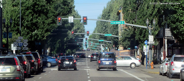
Nothing too profound or prolix about this shot, though I do enjoy the perspective feel that the diminishing traffic signal gantries and overhead street blades provide.

You've got Grand, 6th, 7th, 8th, 9th, and 10th crossing East Burnside here, then that small hill to a slightly higher flat, that's at 12th.


POV is east from where Burnside intersects MLK Jr Blvd (east end of the Burnside Bridge).

Portland's Own Flatiron Block

3950

There's a triangluar block in downtown Portland. It has lived many lives.

This block is bounded on the north by West Burnside Street, on the east by the 300 block of SW 12th Avenue, and on the south by SW Harvey Milk Street, formerly SW Stark Street. There are two buildings on this small block; at the gore point, an impossibly small, unnervingly-narrow two-story building, and taking up the remainder, a four-story hotel.

The tiny building at the point was a radio station studio, KKEY. Those who've been here long enough will remember the big call sign in stacked type adorning that point. Few, if anyone, will remember its programming, which was unremarkable and made little history; back in the day, two people of my acquaint had a show there, but only as long as they could drum up the sponsors. 

What sort of penny-ante operation made its on-air talent (and for KKEY you could use the word rather loosely) do its own sales? Well - I believe I just answered that.

The hotel itself used to be home to a gay swinger's place called Club Portland. In the 1990s, the McMenamins bought the place and got rid of the sordid stuff and graced the whole with a more historic name ... Crystal Hotel ... and that trademark McMenamins bland class. So it goes.

My memories must suffice to describe what once was. This picture is what it is:


West Burnside is in front of us. Harvey Milk Street slants off to the right. There's been a tectonic change to the traffic pattern as well, as one has not been able to veer off Burnside onto Stark for quite a few years, and the Portland compulsion to let people dine in the middle of the street combined with times of Covid has populated that block Harvey Milk Street into a seat of al-fresco umbrellas.

24 June 2021

Immortality Assured Via Apple Look Around

3949

Look at what the Brown Eyed Girl peeped and pointed me at yesterday, on NW 11th Avenue adjacent to Powell's: 


She saw it from back in the Orange Room approaching the checkout; from a distance it looked like a Google Maps Street View car. This is what I found when I got out there though: note the text on the rear door.

It had California plates, which is appropriate.

I learned that Apple is rolling out a feature for Apple Maps, similar to Google's Street View, called Look Around. Unlike Google Maps, Apple Maps doesn't have a web portal though, so if you want to see me taking a picture of them taking a picture of me taking a picture of them, you'll have to employ your mobile device.

I don't know when to expect my image to show up on Apple Maps, as I don't recall how long it takes digital pictures to be developed these days. 

And so it goes.

22 June 2021

Studio Cats of 2021

3948

Took a break from posting for a few days because of an incident I am still unpacking an unpleasant event that had happened in SE Portland that involved taking pictures. 

I may comment about that anon, but I don't know. Since this isn't exactly the most popular chronicle of the times, it wouldn't make much difference, I imagine.

So, here's something cheerful, happy, and lovable. A scene from the corner of the studio, the happiest place on earth, with two of the most lovable things on that earth: Tabitha and Ralph.


We have a daylight basement in our house. It stays about 70F all year long, and with a searing heat wave coming up it'll be a place we'll all remain, probably. And those windowsills are a cat's dream. Wide, flat, spacious. 

These two cats are living their best lives in those windows alone. 

Chez ZehnKatzen, where every day is Caturday.

15 June 2021

21st Century Man, or: My Future, And Welcome To It

3947

This missive, and this picture, document (or attempt to) a singular emotion. 

Life moves past you at an odd clip. It's not constant. And it seems gradual, until that moment it's not. 

I'm aging. I don't make an issue of what my exact age is; if you read enough of my rattling, I'm sure you can reason it out. But it's sunk in that I've been around a while, and despite being born in Silverton and spending my teens and twenties around Salem and Corvallis, I've been a Portlander the majority of my life now (the implications vis a vis lifespan I'll not dwell on for the moment, if it's alright with y'all).

I've seen changes, is what I'm saying. The town I fell in love with as a kid and commenced a long process of killing myself to become a local in has become, fulsomely, a fundamentally different place.

Dig, if you will, this picture.

If you go to the riverside esplanade just the other side from Naito Parkway of the Waterfront Pearl condos, you go to the north end of that walk, which is as far as it goes (for now), and you look southwest, you see the above view. 

The street intersection is NW Naito Parkway and NW 9th Av.

I spoke of changes. I used to work in this area at a building that still stands where NW 15th and Thurman merge and cross the railroad tracks, just across from where NW Naito Parkway reverts to its seminal name, NW Front Av. I doubt that anyone living now in the condo tower forest that has spread from the Main Post Office building to that point can even envision that it was once a rather vacant urban wasteland; a big rail yard. I still remember. My office left that area around 2005; from our offices windows we watched the steady encroachment of development. Not even I figured it would get that far but there it is, now.

There were comics when I was a kid, where the protagonist would be projected into the future. They'd look around, gobstopped in wonder, as they viewed great glittering futuristic towers, sided in glass and shining steel, some with curving, sculpted sides and they'd stare agape at architectures they could only just comprehend.

As I looked at those buildings from that point on that day, a certain emotion started in my head and reached down and took hold of my heart, and I realized that I was that guy. This was still Portland. I still grokked the geography. But something that was, within my adult memory, acres of vacant lots and rail yard had become this hulking, crowded thing.

Same planet, but a different world. And I was aware of it, as though it was, for a moment, a palpable thing, a thing that could be held in my hand.

Parents have had this feeling, in their times and ways. Our collective descendants will have the same experience, Anthropogenically-induced environment change-willing. 

And now, I guess, it's my turn.

This Picture Really Sucks

3946

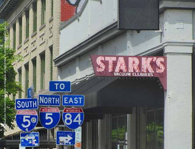
This should go amongst one of the Portlandest pictures ever. For reference, this is facing westbound at the corner of NE Grand Avenue and Couch St.

Stark's Vacuums is one of that vanishing breed of quintessential Portland purveyors of commerce that is not only as Portland AF but also has survived through generations; 2022 will mark Stark's 90th year in business. If you wanted a really good Covid-era face mask, you've been there latterly. If you want a great vacuum, you will go there. And if you're not near this one, there are nine locations scattered across the Portland Metro area.

This particular one has been kind of the Home Office of the company. This, NE Grand and Couch, is the location that holds their renowned Vacuum Museum, which once occupied the windows looking out onto Couch you can see in the photo, but has been moved to another part of the building as the Couch side has been made into another leasable space.

Looking at what's been written about that Vacuum Museum, you get an idea that
vacuums aren't just something Stark's is good at selling. This outfit is scary serious about them. But, then again, Portland's always been good at being intense about things long before they're cool; Stark's was rocking vacuums back with 'Dyson sphere' was just something SF writers and astrophysicists talked about. They also have the best damn logo anybody ever came up with for a vacuum cleaner company, and I will fight you on this.

This picture sucks. But totally in the best possible way.

Thorburn and Gilham

3945

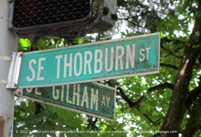
You have to be watching very carefully to know when you cross from one street to the other here, because it won't seem like you have changed from one street to another at all.


SE Thorburn St and SE Gilham Av serve one main purpose in the Portland traffic greater-scheme-of-things: channelling traffic from E Burnside St at a point just east of E 67th Av around the shoulder of Mount Tabor and down through Montavilla on the Stark-Washington couplet. Though one is technically an avenue and the other a street, due to their layout, which respects the topography of that side of the mountain in order to have terraces for salable housing lots, they meet at such an acute angle that if it was any smaller they'd be parallel streets.

At any rate, SE Gilham Av is the most advantageous connection to Thorburn east of Gilham which goes from a 2-lane neighborhood street with speedbumps collecting traffic from Stark west of Mount Tabor to a four-lane boulevard after Gilham merges in. There are an annoying lack of of visual cues to hint to the driver they're actually on a different street now, reinforced by the way the grading directs traffic.

Long story short, if you want to just get to Montavilla off East Burnside, just go with the flow. If you want to know which street you're actually on, look sharp; there are weathered signs hiding in the foliage.

Stark Street, Montavilla

3944

Another one of those tight zoom shots I love doing so much because they make me think telephoto. 


This is looking down SE Stark Street into downtown Montavilla. The hillside ahead is the north shoulder of Mount Tabor.

There's an interesting thing I found out about Mount Tabor recently. Apparently there's a standard for height below which a peak will not be named "Mount" by whatever geographic nomenclature authority applies (a board under the aegis of the USGS, I think) and Mount Tabor does not meet that standard. However, since generations of Oregonians have called in Mount Tabor, the history of the name establishes the right. 

The name Montavilla was inspired by Mount Tabor, but in an indirect way according to the book Portland's Streetcar Lines, published in 2010 by Richard Thompson. The community was named Mount Tabor Village, originally, but signage of the first streetcar lines abbreviated this Mt. Ta. Villa. Over time this evolved into Montavilla as the coinage grew popular. 

The streetcar line died long ago. Its cultural rubric child, however, has never been stronger. 

Also, at 76th and SE Stark, you'll find Mr. Plywood. Best urban lumber store ever. Just take my word for that.

13 June 2021

Bridge Day #3: The Golden Gate Bridge From 2009

3943

The following not a picture I took, but one that my spouse, the Brown Eyed Girl, took back in 2009, and is one I wish I took ... not because I can take it any better, but because I was not in San Francisco with her. I have used it hence without permission from her, yet.

The Golden Gate Bridge should need no further introduction. And this is a fine, fine picture of it.


I did take one liberty, and that's playing with the color saturation. I upped it, and it looked like one of those pictures you see on postcards with the saturated color, and I found it so charming that I had to roll with it. It was taken, as said before, by my spouse, who was in California for a few days helping a beloved friend relocate to Modest "O".

San Francisco is such a romantic city to me. I care not for bucket lists, but as far as I have one, visiting San Francisco with my love is on it.

Bridge Day #2: The Fremont Bridge

3942

Bridge number two of Bridge Day is one of the ones built during my lifetime. As a matter of fact, I got to watch it on TV ... had to, I'd say. I was living in Silverton at the time.

The Fremont Bridge was the final link in the inner city freeway loop that is formed by I-5 and I-405. It is a tied-arch bridge, and made news because the center of the span was fabricated in California, assembled just downriver on Swan Island, and barged from Swan Island to the worksite, where it was hoisted into place using 32 giant hydraulic jacks. 

They telecast the beginning of the lift early one evening in March 1973. I don't know how long it took but the allotted program time wasn't near enough long, I'm certain.

A schoolkid at the time, I made numerous drawings on looseleaf. It became something of an obsession.


It's almost 400 feet up to the top of that arc from the river. It also has a nest of peregrine falcons.

Bridge Day #1: The Broadway Bridge

3941

Today is Bridge Day for no other reason than I had three bridge pictures to post.

We at The ZehnKatzen Times do not plan on making this a repeating thing, although I live in a city that has bridges and I adore them, they'll sneak in here from time to time.

None of them are pierless, I'm afraid.

From last week, then, a bridge I don't have so many pictures of: the Broadway Bridge. It's a Rall-type bascule (Rall after the man who devised this particular method, and bascule meaning drawbridge with a leaf or two leaves as the draw span) that was built in 1913. It connects Broadway on the east to Broadway on the west, and that precedence is important because Broadway, in Portland, was born on the east side and only became a west side street after this bridge connected it to Seventh Street North and the name was extended. 

Until the Great Renaming, it was known as Broadway south of Burnside, Broadway North north of Burnside, and East Broadway east of the Willamette.


The connection, which completes a stringing of Broadway through four of the city's now-six address areas, makes a most unique route of Broadway, technically both a Street (east of the river) and an Avenue (west of the river). As I understand it, though, the correct rubric is simply Broadway, no Ave or St, though there are some older blades on the east side that may still say NE Broadway St, and are being superseded by the new-look street blade design.

The design of the lift mechanism makes for some slow bridge lifts. Multnomah County's page on the Rall design cites it as the slowest lift of all the bridges, with average lift times of ten minutes.

Having been caught on the Broadway during some of those lifts, I can confirm. It takes forever. If you have to be somewhere and time is tight, use another bridge, if you can.

You'll thank me later for this advice, I'm sure.

12 June 2021

Big Pink From The West End Of The Burnside Bridge

3940

This is a picture that I've taken before and perhaps have even posted versions of before here. This is coming off the Burnside Bridge, effectively over Naito Parkway, so we're about 5 blocks east of Big Pink, approximately only 1/4 mile.


Our skyscraper now dwarfs the surrounds, well exceeding the visual weight of the West Hills just beyond. The coloring that gives it its nickname stands out a little better. Its importance to the Portland skyline is obvious now.

It stands at the north end of Portland's historic downtown core, and, as such, has a lot of older Portland buildings around it, unlike the Wells Fargo tower about three-quarters of a mile south along the same street, which is surrounded by a waist-high forest of newer towers. Big Pink stands out more. 

And coming down into downtown down the gradual slope of the west end of the Burnside Bridge is also a fun feeling. I never tire of it.

That's the third part of the triptych, and thank you for following me downtown. Maybe soon we'll make this trek back to Powells, as we used to do so regularly. Things need to heal up a bit more, though, I guess.

Big Pink from East 32nd Avenue

3939

This is the view of our objective from where 32nd crosses East Burnside, the eastern gateway to the Laurelhurst neighborhood.

Between the last photo and this, The Burn flattened out from 60th until 47th. At 47th, the road dips and goes into the grove of trees that are a trademark of shady, leafy Laurelhurst, and the Burnside does a little bit of a sway. It straightens out quickly after it crosses César E Chávez, and being at the brow of another slope provides another bit of advantageous topography.


I really hate that car in front of us. Spoilt an otherwise perfect shot. But there it is, hail Eris. Visible also in front of Big Pink there is the newly-built 5MLK building, at the corner of SE Grand and The Burn, which looks immediately adjacent due to foreshortening but is actually on the same side of the Willamette as we are at this point.

Next photo closes the rest of this gap.


Big Pink from East 60th Avenue

3938

One thing I have never gotten tired of, having come through life from Silverton to Salem to Portland, is the sight of skyscrapers.

I absolutely love them. Besotted, you might say.

And one of the best things about them is the advancing view one gets from a distance. They seem truly majestic. 

Case in point.

I give you the USBancorp tower here in Portland, At 532 feet in height and 42 stories, it's the second-tallest building in Portland (and, thus, Oregon). Its footprint is that of a parallellogram, the west and east fronts being parallel with SW 5th and 6th Avenues and the north and south fronts with West Burnside. It respects its geography. Since Burnside runs a straight line between the east side and west, and the terrain is advantageous in more than one spot west of the shoulder of Mount Tabor, you get to see it get closer and closer as you do.

This, for starters, is the view down East Burnside from its intersection with E. 60th Avenue*

Straight ahead and on the left is our quarry. The color of the building itself has lent the name Big Pink to it, and since USBancorp really isn't much there anymore, it's a better name to call it, anyway.

This was lensed at about three miles out from ground zero (20 blocks to the mile). The next photo will about halve that.

* Since the directional changes at Burnside, there has, in my personal writings, been a convention to use both directionals, e.g. NE/SE 60th, but I've never liked the awkwardness of it. A convention has developed to simplify it to, in this case, "E 60th Ave", and this is one that TriMet has used for its MAX stations along Burnside for years, and it has a schematic simplicity to it as well as harkens back to when numbered streets east of the Willamette were simply referred to, south of the Burn, as "E", so I too will be adopting it from henceforth. This will be in references to intersections with E Burnside only.

11 June 2021

Storm Tossed A Blanket over Wy'east

3937

Rain's coming this weekend, they say. Then warm and sun. But first, Oregon rain ... the real stuff.

Wy'east anticipates.


 The clouds on the right hand side give The Mountain almost a Tahoma-like chest. The thin window in the cloud deck on the left, letting a great shaft of light illuminate the north slopes, is unique and memorable.

10 June 2021

News Lane, Seattle, 2010

3936

Another thing that leapt to the fore as I was reviewing (and, it must be said, pining a bit) over the photos I took in Seattle in 2010 on me and the Brown Eyed Girl's 20th marriage anniversary.

I was, of course, out for interesting street names and signage. That should go without saying by now but it ups my logorrheic quotient so here I am for you.

Here, in August of 2010, was a sign that struck my fancy on more than one level.

This was taken at, as near as I can determine, where News Lane crosses Pike Street. The named alley (that's all it is really) runs between 1st an 2nd Avenues. It's quite close to the famous Public Market. 

Any connection to any news, organization or otherwise, had left the Lane long ago. While the old P-I building is in the area, that might have been a coincidence, for all I knew. Or know.

Here's an angle on the street itself, looking south from Pike:


I could have a fugitive-drama or hard-boiled story set here. I'm getting heavy Harry In Your Pocket vibes. I'm charmed by the toy-camera fade out on the margins, which is a thing of mystery because I took this with the legendary ViviCam 3705, which wasn't that sophisticated.

This is a view looking north.


The only question on my mind about this photo is which cross street I was at when I took it. The angle on the building at the far end of the way indicates it's at Stewart Street, where the grid pivots to follow the bay short, and with only about block's distance, this should be at Pine Street. I also recall begnning to be very tired from walking all over Seattle's downtown, enjoying the views, but in terribly inappropriate shoes. An additional block, even going from Pike to Pine, would have been intimidating at that point. Yet the visual information leaves me no other reasonable alternative to assume.

We're planning on seeing the Oregon Coast later this year and making up for the fact that our 30th anniversary came during a pandemic year with about a dozen other centrifugal forces messing everything up. But do I want to be with her in Seattle at least one more time? Yes, Yes I do.

Current searches of the area on Google Street View show no evidence of the blade, though it is still noted as such on Google Maps.

09 June 2021

Another Sort of Portland Loo

3935

Some years ago, the City engineered a public bathroom solution called the "Portland Loo" which is a built thing and can be seen across the city in some parks and in the Old Town area of inner NW Portland.

There is, though, another sort of Portland loo, and it's much more portable.


It's much more forthright about the reason it's there, too.

IMSO, this City has stumbled on a number of issues over the last several years. This, however, is not one of them. This is a positive public good and extraordinarily humane, and, sometimes, just the thing you need when you need it.

Dark Rays of Light Through Overcast

3934

Taken yesterday morning, in NE Portland, near the airport. The impression I had was of sunlight filtering through clouds but there was something very dark about the light that day.


It's kind of a just-on-the-level-of-visible thing. The cloud cover is certainly gorgeous.

08 June 2021

Where The Elite Meet And Greet On The River

3933

They say Portland's gotten expensive.

Well, look at what gathers on the riverbank these days. Pretty soon, you'll have to earn six figures just to camp out in the park.

Tilikum Crossing: Bridge of the People, meet Big Ol' Yachts: Marina of the Rich People.


How The West Was Won On South Harbor Place

3932

More color at Riverplace. A bit of Western colonization myth.

Just after you leave Harbor Drive on S Montgomery St there, immediately, is a short frontage street called (unsurprisingly) S Harbor Pl. Turn right on that and go to the cul-de-sac at the end, and look left. 

A cartoon mural. Yippie-ki-yi-yay, if you follow.


It looks all Roy Rogers and Dale Evans, with a dash of ELO's "Wild West Hero" thrown in, and laid out in a comic book. 

Equally topical is the tent, but for different reasons.

United Colors of Riverplace

3931

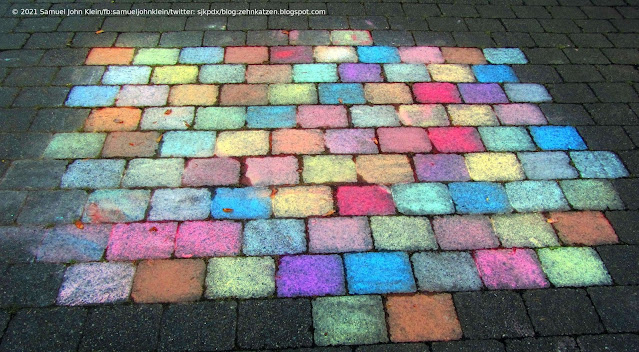
When we were at Riverplace a couple of weeks back, I saw that someone had a great deal of fun with colored chalk on the pavers.

I found it delightful.


We'd wondered where the colors came from, then we noticed the almost-kiosk-sized coffee bar immediately to the right of this, it's on maps as Pájaro, and it was hard to tell if it was closed due to reduced hours or pandemic-defunct, but the colored chalk was in there.

It's Not Really That Bad Out Here, I Don't Care What The Sign Says

3930

Just south of SE Washington St, adjacent to Mall 205, the very short couplet that is SE 102nd Ave/SE 103rd Dr merge to form a short diagonal road called SE Cherry Blossom Drive with connections to SE 112th Avenue, Portland Adventist Hospital, SE Market Street and a range of places south, east, and west of there.

I put this in front of you because I noted, on my commute home, that the back of the sign has been creatively edited.


I have a number of issues, here.

The least of which is that the area this opens up into, a little, beige, bland, banal Portland neighborhood called Mill Park (which is my home: I'm a perfect fit!) is about as far away from Hell as can be. It would be, at best, the Gateway to Heck, or maybe the Gateway to Darn, the Portal to Shucky-Darns, or the Access to The Place Where They Ask You About Your Car's Extended Warranty.

Not really a fair cop here.

Another question that comes to mind is that this is actually the side of the sign that thanks you for coming, which really raises the question of whether or not Hell has revoked its formerly one-way policy and is now promoting package tours to make a few extra bucks.

It is that kind of age, after all. And things have gotten tough; after all, just before we out here settled the question of how many angels can dance on the head of a pin, Fabric Depot up and went out of business on us.

05 June 2021

Towers of the South Waterfront

3929

Portland's newest "neighborhood" from a vantage point across the Willamette River.


In the 2000's, someone looked at a lot of low-lying, old industrial land along the river and thought You know what would be nifty here? A sterile residential district with cold, monolithic towers featuring architecture that wouldn't be out of place anywhere. That's Portland!

And they got their wish. So inspiring!

A View of the Portland Harbor From Mock's Crest, 2009

3928

About twelve years ago, me and the Brown Eyed Girl were enjoying a mid-summer day on the lip of the bluff that is crowned by the University of Portland - a summit known as Mock's Crest.

It's almost a perfect semicircle. It can be pretty easily identified if you find North Willamette Blvd west of North Greeley Avenue; it clings to most, but not all, of the cliff's top. The remainder is the UP property.

It offers a wonderful view of Mock's Bottom and the lagoon that, at one time, was the man channel of the Willamette River back wen Swan Island was still an island and, not coincidentally, part of Swan Island itself. 


The picturesque sweep of Portland from many angles is what makes me come back to this sort of space again and again and again.

The water is the Swan Island Lagoon and the opposite bank is the north side of the Swan Island peninsula. The Island has gone through many changes; originally a true island, with the main river channel on the north side, it was levelled and graded and connected to the bank with fill and became Portland's airport during the 2nd quarter of the 20th Century. An ill-starred thing, this, as a mere few year after going into operation, aircraft needed landing strips that were bigger and longer than it could provide. The international airport moved out to the northeast side of town, along the Columbia, and Swan Island became Portland's industrial and marine terminal heart. 

In the distance, the Fremont Bridge and downtown Portland, about four miles away from this POV, complete the tableau. An incomparable profile.

04 June 2021

The Inside Of The Midland Library, Fourteen Months On

3927

This is a view of the Midland Branch that I was beginning to despair ever of seeing again, looking down the middle of the building as though we were going to find seats at the back and sit in for a few hours.

We didn't get to stay long, and it wasn't nearly enough, but it felt good. Staff dispersal wasn't complete, and we're happy to see a few familiar faces there. Some pieces of our heart have gone on to other branches, or chose to retire, but the pandemic has been a real society-quake, rattling things to the four corners. I guess we'll have to come to terms.

Just before Covid went full-tilt boogie, there was a re-arranging going on here which was scheduled to conclude just as the world went into lockdown. Largely, though, it appears to have been in the children's section; the shelves line the building in the same way, and the computer stations, though not yet in use, are in the same places. 

It took a little poking around to find books of my interest but not much. 

There were tables in the back area, where we usually sat, but they're spread out a little more and not in business yet for those of us who might want to linger long; areas of the interior are corded off. It all feels a work in progress still.

But if this is all possible, could a return to relative normality be so impossibly far off now? I'm certainly hoping it's so. 

More on this story as it develops.
 

Seattle From The Space Needle, August 2010

3926

I accidentally took a detour into a certain folder for reasons only my psyche knows right now. 

It's August 2010, and me and the Brown Eyed Girl were in Seattle. It was our 20th wedding anniversary. It was the kind of adventure that we have far too infrequently, and we wanted to do something similar for last year - our 30th - but last year was shit on more than one level, for the world and for us personally.

But then, in August 2010, the world was still pretty bright and shiny, and she wanted, amongst other things, to show me what it was like travelling to Seattle on rail, something she did as a child to see relatives. And, me, well, I've always been kind of fond of Seattle ... well, as much as a Portland chauvinist can be.

The old ViviCam 3705, in all its 3.2 MPx glory, recorded some stuff. Ought to go back with the camera I have now, we ought. Hell, we ought to just go back. I owe her that much.

This is the ol' Plastic Fantastic recording a much-recorded view: downtown Seattle, dusk encroaching, Tahoma/Mt Rainier dominating the horizon in that dominating way it dominates. It's a brute of a mountain, broad-shouldered, blunt, and massive where Wy'east is delicately drawn and modestly-positioned. I will say I prefer my home volcano, but Tahoma is certainly nothing to scoff at (as is true with its potential lahars)


Seattle is an improbable city to me. Skyscrapers that are much too tall stand rocksolid on downtown hills that are far too steep to hold them, but somehow they do; a massive city on a narrow neck of land. To this simple provincial, it's a place that's bewildering as it is pretty.

I'd like to go back and visit again. We have a deferred celebration to think of.

03 June 2021

A Welcome-Back From The Mighty Mighty Midland Branch of the Multnomah County Library

3925

Evolution toward a post-pandemic level of open society continues. The Multnomah County Library system has initiated what the call Stage One Reopening.

In April of 2020 we were habituating the Gresham branch due to Mighty Mighty Midland's temporary closure due to a bit of rearranging and re-doing of the interior. Just as that temporary closure was set to expire, the Covid-19 pandemic roared in ... and all library branches were physically closed, indefinitely. 

That was fourteen months ago. And, since then, MultCoLib has gone through some evolutions of its own: the ending of overdue fines (we approve), the institution of a contactless hold pickup protocol (we also approve), and the shuffling about and reduction of staff (we do not approve and are still sorting out our feelings about this). 

However. On 2 June, 2021, Stage One reopening in in effect. For the first time, in over a year, we could go in to the library, our heart we love so fondly. Stage One, for what its worth, is basically this: a limited number of people can be in the building at a time (at this time, Midland's limited to an occupancy of less than ten), and you can browse for up to thirty minutes, or stay up to an hour if you want to use tech, such as Wi-Fi or the branch's Chromebooks (the computer stations are not in service as of yet).

I have some more pix, which I'll share in a subsequent episode. But, for now, enjoy this banner, and the heartstrings, it tugs upon them.


The banner is sincere. The feeling is decidedly mutual. 

01 June 2021

NE 122nd Avenue Looking North on a December Morning in 2017

3924

Dredging through some old pictures, I found this one.


My favorite street in the world, E 122nd Avenue (NE 122nd, in this case) looking north from the pedestrian overpass just north of San Rafael St, near the ECR recycling yard. 8 Dec 2017, 7:35 AM (I just love EXIF data, don't you?). 

A particularly delicately tinted morning. I don't remember anything else about it.

It's All Fun And Games Until The Kaiju Show Up

3923

Never doubt the power of Godzilla to hold your place in line and to negotiate payment of the meal bill with the cashier at the burger joint.


Fortunately, the crew at Cruiser's Cafe was pretty cool about it all. Kaiju or human, you still get great, local fast food there. Seriously. Their crinkle-cut fries are flawless.

A Legacy of Ross Island Sand and Gravel

3922

This is an ready-mix concrete facility that has apparently recently or is now in the act of behing retired. Part of the Ross Island Sand and Gravel constellation in the area along the Willamette and between the river and SE McLoughlin Blvd.

The facility gate appears to be at the corner of SE 4th and Ivon, and the interesting thing abut the place is how neat and tidy ... well, for a cement plant, anyway ... it seems to be for being in the state it seems to be. A coat of spray-paint tags, some quite skillful, is well in evidence but it doesn't seem to be a mess outside of that.

A look at Google Street View, last one is 2009, shows the facility without tags. In the intervening 12 years, RISAG have largely wound up operations; the iconic lot on SE Mcloughlin just north of Holgate Blvd, where a dedicated crew used to wash all the mixer trucks each night and line them up with laser-precision for use next work day (wish I had gotten pictures of that, that was something special) is now empty of said trucks and Dr. Pamplin, the owner of the company, has moved into media to lose his money that way.

The Ross of Ross Island

3921

In the Willamette River about two miles south of downtown Portland is a place where the river widens to about 4/5ths of a mile across, and in this widening is a bit of land that looks like a lobster's claw. 

It is what remains of two islands that were mined TF out over a period of years by the Ross Island Sand and Gravel Company, an era which finally ended about five years ago. This horseshoe, the left half of it, is what remains of Ross Island, named for an early colonial settler.

At the east end of its namesake bridge, there is a plaque installed that tells you about him. 


The island on the left, Hardtack Island, could be named because its position might cause boats passing the islands on the east to turn really decisively, but I prefer to imaging that Sherry Ross liked hardtack a lot. 

Hey, he got to and from his property by boat. It could have happened!