06 July 2024

What Kind of Burnside Bridge Do You Want For The Future?

4161While the process grinds forward on the redux of Interstate Bridge 2.0, the process is rolling along quite smoothly on the planning to replace the Burnside Bridge.

The current bridge is gorgeous, laden with history, a classic of design, a linchpin of Portland's geography, and will collapse like a Republican excuse for not doing the right thing when Cascadia Next happens. It's apparently advantageously situate for keeping the city together in the wake of that anticipated cataclysm, so the goal is to have a Burnside Bridge that will not shake down when that 'quake finally happens.

In the apres-quake times, the most important thing for getting Portland back on its bearings ... however long that will take ... will be eastside-westside connectivity and access.

The opporunity is being taken to make the new-Burnside-Bridge-to-be another example of statement architecture that we Portlanders are so very fond of. There are two options to consider; a tied-arch bridge, similar to the Fremont Bridge, and an cable-stayed bridge, using the technique that was built into the Tilikum Crossing. 

These two styles are asymmetrical; the signature architectural part, the arch in the first case and the cable-stay tower support in the second, will be over the Interstate 5-east end of the bridge, leaving a span over the middle of the channel for a the necessary drawspan for river traffic and for making Portland tourist wonder why they had to stop on the bridge in the middle of the day.

There are also variations on each style. This picture, sharked from the Earthquake Ready Burnside site, shows the beauty profile of the tied arch look from a point in Tom McCall Waterfront Park on the west bank:

Source: https://burnsidebridge.participate.online/tied-arch.html

Driving over it will look like this ... which reminds me of a crossing of the Fremont, which has always been a love of ours:

Source: https://burnsidebridge.participate.online/tied-arch.html

The other option, the cable-stayed version, looks this way:

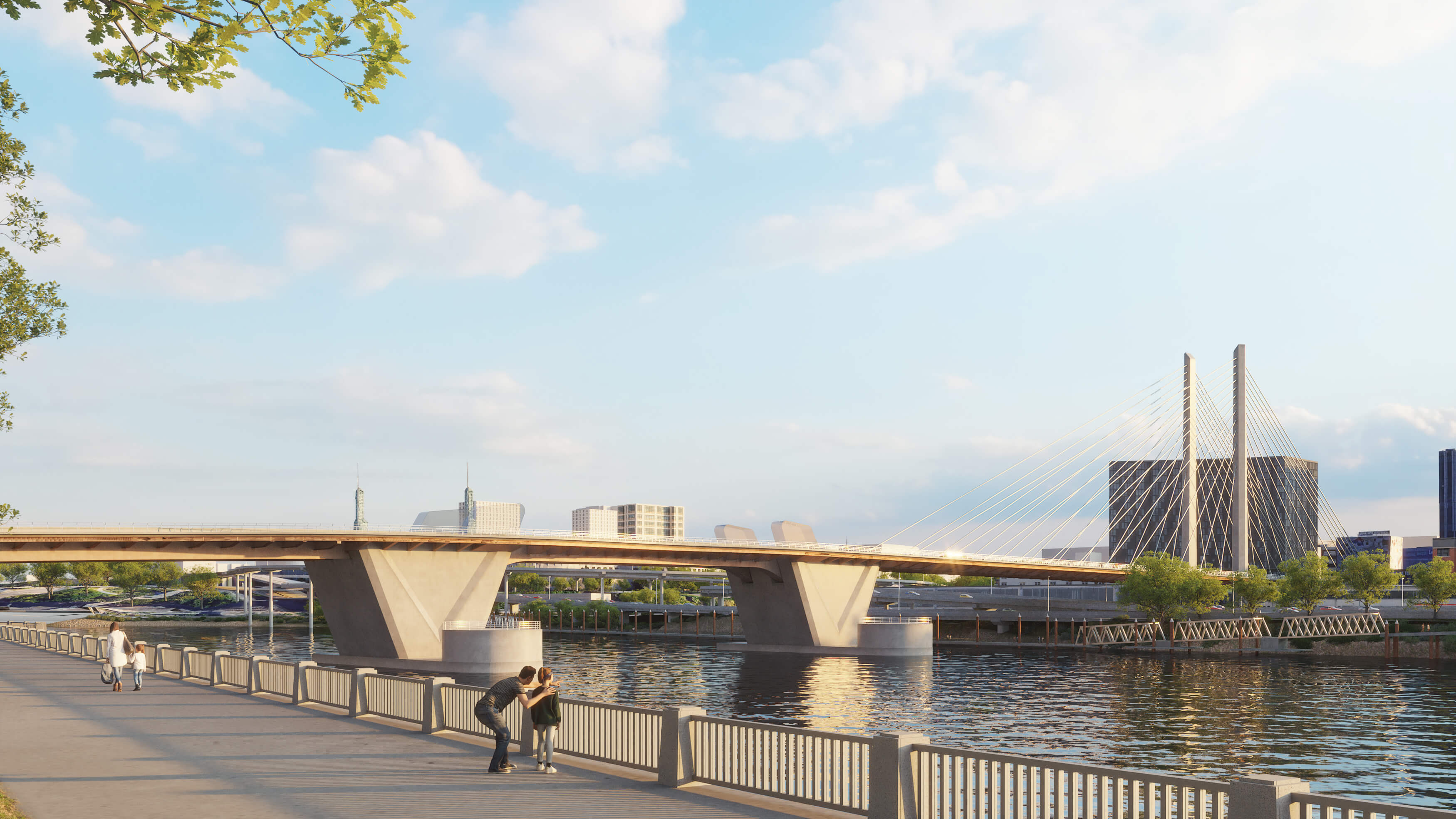
Source: https://burnsidebridge.participate.online/cable-stay.html

This version will have taller towers than the arch-style, but the visual presence isn't there for me. However, the asymmetry of the cable stays does have a element of dynamic style in it.

There is a survey on line that anyone can submit their opinions and personal preferences into, it's found at https://burnsidebridge.participate.online/survey.html. The homepage of the informational website is https://burnsidebridge.participate.online/, of course. 

In the near future, this bridge will close for a remarkably-long five year span for this replacement. I don't even remember the Hawthorne Bridge being closed for that long back in the 90s when they updated the eastside approaches.This will be something to contend with for a lot of us on all levels. I'll be recording everything I can about it and posting it here as I go.

We were there for the opening of the 21st Century Sellwood Bridge, and I'll put my anchor down here; I'm looking forward for us to be there for the opening of the 21st Century Burnside Bridge as well. In the meantime I'm going to be finding us taking many more pictures of the current span; it's a charming architectural gem, and that passing will be notable. 

04 July 2024

The North End of Waterfront Park

4160Tom McCall Waterfront Park stretches along the left bank of the Willamette in the center of Portland for over a mile. It not only is Portland's most direct connection to the River but also represents history; Harbor Drive, the downtown freeway, once ran through this slender strip, also one of Portland's most remarkable buildings of the past, the Public Market Building ... later the headquarters of the Oregon Journal, where columnist Doug Baker planted the seed of imagination that grew into the mighty mite that is Mill Ends Park.

A small tab of Waterfront Park extends north of the Burnside Bridge, only as far as Everett Street.


Here Naito Parkway curves through the middle of the view and then ducks out of view to lead to the apartment district of inner NW Portland, and a ramp curves up and to the right to connect to the ancient Steel Bridge. 

In the foreground can be seen some of the Japanese American Historical Plaza. While this area is known for being Portland's Chinatown, before it was Chinatown, it was Japantown, and this was its southeast corner. A sculpture, out of shot at this POV, tells that story.

03 July 2024

The Woonerf Comes To Everett

4159... and just what is a woonerf? How about a chamfer, for that matter?

Everett, Washington is taking a number of approaches to revitalizing its considerably-extensive waterfront and making it welcoming to people. And, to that end, one burgeoning development, accessible from Marine View Dr W via Thirteenth Street, is a redevelopment of a large pier area where lumber and shingle mills used to rule; they're calling it the Millwright District. There will be retail, residential, commercial; all the urban things.

Circling the area is a new street known as Millwright Loop, giving the area the vague outline of a spatula when seen from above. And there's this:

Chamfer Woonerf. Photo courtesy Benjaming Donguk Lukoff, used with permission.

It shows up here on this street blade: CHAMFER WOONERF. It's a street which serves the interior of the spatula's blade.

And, of course, that brings us to the question of what a woonerf is, and as it turns out, it's simple to answer, and like the much-maligned bioswale, it's something we had all along and is nothing really new (we called bioswales French drains once upon a time and didn't make a big deal about it), but it does have a certain approach and attitude inspired by European point of view.

A woonerf is just a street designed to allow automobiles but also designed to accommodate people activites; some call it a living street; sort of a cross between a public plaza and a side street. People and autos share space. It became a modern thing in the Netherlands, where it picked up its strange name. And, most importantly, it's a street that easily gives itself to public events like street fairs and festivals. And it would be an ideal thing for something in the center of a destination district.

And a chamfer, for those who don't know, is a woodworking thing where you knock the corner off a form. 

So, Chamfer Woonerf. Strange name, but it'll catch on.

02 July 2024

PDX: City of Buildings

4158Today, we go abstract and zoom in so that the building faces presenting themselves to me, from my POV on the Burnside Bridge.

Just a piece of downtown Portland devoid of connection to the surroundings because of my choice of angle, making it nowhere and everywhere.

Although the billboard does kind of give it away.

01 July 2024

Again, A Portland Hellscape: NW 1st Avenue Between Burnside and Couch

4157Certain people trying to get a rise out of you will insist that Portland is not only burning, but in ashes now. 

It gets them fans.

On Saturday night, this is what NW 1st Avenue looked like between Burnside and Couch:


Old Town is a destination, but it's been so commodified that if you're there anytime after business hours, it's so deserted in places, it's just a liminal space now. 

Well, to be fair, the MAX stop there under the Burnside Bridge did kind of smell of pee. And there were homeless men lining up for admission to the Portland Rescue Mission, but homelessness is a thing that exists here in Portland. And the Rescue Mission has been there for decades. 

Of course, anyone willing to take the mental effort can imaging burning cars and derelict people out of Escape From New York, if you wanna. I can't stop you. And if you look far enough, you'll see a junky tent on a streetcorner. Portland's a Big Town, and those things happen here ... Portland doesn't strictly reserve the rights to that.

But anyone who thinks that Portland is a hell hole consumes too much right-wing media, and needs to get a damned grip. 

An Icon in A City That's Made Of Icons

4155It's the sign on the White Stag Block. We all know about this one.


Began life as the sign for White Stag Sportswear; became Made in Oregon for a while, and then the University of Oregon wanted to place their name up there.

That didn't go over well. The Ducks are popular here, but not that popular.

At that point the Portland City Council stepped in, led by Randy Leonard, buying the sign and making it an official symbol of the city. It's said Portland Oregon ever since. 

The tradition of the red-nose on the leaping stag has maintained. Ploosa shaunge.

22 June 2024

I Can Feel The Heat, Like A Spanish Dancer ...

4155Well, not a Spanish dancer, strictly speaking. And not just one.

One of the delights of the Multnomah County Fair a few weeks back was the stage; there was something going on there nearly all of the time and all you had to do was wander on by and take a few minutes and take it all in.

These dancers were full of furious energy, and it was colorful and beautiful.


I've got a few more of the '24 Multnomah County Fair to share. They'll make appearances.

20 June 2024

The Lower Level of Oregon City

4154This is a view of the first city of Oregon, Oregon City, from the balcony of the city elevator. The date is March, 2014.

Oregon City began as a town on a fairly narrow shelf between the Willamette River, just downstream from the great falls, and a cliff. It's a unique geography that constrains the feeling one gets in town, and how that town grew, and provided for one of the more unusual municipal structures in America.


 The unusual municipal structure is that Oregon City Elevator. It's free, it's a dedicated public street, it's a gorgeous design (sort of Art Deco mininalist), and its fun to ride and decorated with much history.

And it gives you a view most people go to the trouble to used a drone for.

For all its history and longevity, Oregon City is a modest place. It's got a population of about 37,000 as of 2020, a modest footprint of about 11 square miles, and a small town feel that's terribly convenient to the big town. And the feeling one gets walking in downtown OC is a cozy, charming feeling.

In the distance, over the Willamette River, one can see the Abernathy Bridge, where I-205 crosses the river. This view looks generally north.

19 June 2024

Remembering the Santiam Wildfire By Watching Mt Hood Go Away

4153Another picture that grabbed my attention as I strolled through my photo archives.

Dateline? Early September, 2020. The Beachie Creek Fire, and others up the North Santiam Canyon had combined into the Santiam wildfire which would dominate local events for about two months. The fire wasn't considered contained until the beginning of December 2020.

The mantle of smoke spread up north from the mid-Willamette and eventually covered the Portland Metro area. We were headed up to Vancouver to do a thing, and the smoke was intruding into the area at that time. I got many pictures of the sky.

But it's this one, with Wy'east over the Columbia River, shot from the Glenn Jackson Bridge, that stays with me.


It was the last clear air day before what was to be weeks of air the quality of which I had not seen in my lifetime and so far - the fates willing - I don't see again.

We can't be sure about that, though, the way things are going.

The Mural at the Back of the Elsinore

4152I was taking a stroll through my photo archives (have I really been taking amateur pictures for that long?) and I found this photo I took in Salem back in 2017 while me and spouse were on a visit there:


This is the back (east) side of the building containing Salem's Elsinore Theater. The view is from the corner of Church and Ferry Streets SE, on the edge of downtown Salem; to get this viewpoint, go west of Bellevue St SE from 12th St SE, then follow the curves through Pringle Parkway until you get to the light at Church Street. Look to the right. The facade of the Elisnore faces High St SE, one block west of here.

If you've ever seen the front of the Elsinore or been inside you know why it's Salem's palace of fine arts and live performance. Back in the day, though, it was a movie house, and kind of worked as a pair with its counterpart on State Street, around the corner, the Capitol Theater.

The Capitol Theater closed decades back and was eventually razed.

The Elsinore, however was where I saw Star Wars back in '77, Star Trek: The Motion Picture in '78, and a number of popular and Disney films during my teen years. As it moved into the 80s it got reinvented as a live performance space and stands as the grand dame of the Salem arts scene. But even before this, this mural happened.

The icons are from the golden age of motion pictures. And it went up sometime in the late 70s; I remember viewing it quite often, as I lived in east Salem and used Cherriots to bus to school at Sprague (Salem Public Schools let you attend the high school of your preference at the time, and I grew to know the State and Fairview and South Commercial routes like they were a personal vehicle) and when I was inbound on the State and Fairview route, it usually went through the Ferry and Church intersection.

So this mural has been up for more than 50 years, and it still looks lovingly tended to, which is one of the neatest things I can think of right now.

Up, Up, and Away

4151This is the plane in the previous photo, just lifting off from runway 10L-28R, headed, for the moment, into the west, bound for parts known only to the pilot, the crew, the passengers, the tower, and airport administration ... but not us. We're just spectators.


On a whim, I drew a box around the plane in GIMP and saturated all the color, bringing a little bit of artistic interpretation into the photo. 

Flying aircraft seem to be in their own bubble.

PDX: British Airways At Take Off

4150The plane taxiing in front of the PDX control tower/parking garage/terminal is a British Airways jet, which was a pleasant surprise - we didn't know BA had flights into PDX.


The life of an international airport, at a glance, in a frame.

The Patron Saint of PDX?

4149Recently my spouse and me were driving along Marine Drive alongside PDX, like we do, and we pulled aside to watch a jet taxi and take off, which we don't get to do a lot, and I noticed that someone had committed a devotion of an indeterminate sort on the fence post at one of the gates.

It left me bemused. But what confused me the most? Was it that someone did this at all, in a place you weren't likely to stop and see, or that she vaguely resembles Demi Moore?

The world will never know.

17 June 2024

Tsuru Island - Gresham's Japanese Garden, Part 3

4148Last missive, I posted a look out the portal window of the gazebo in the middle of Tsuru Island. This is what it looks like if you step out and take it all in:


I do really feel peace as I look at this. Japanese culture has a reputation for encouraging nourishing introspection and reflection. Its art and mingling with nature do that for me unlike few other things do.

One of the centerpiece features of the garden is a dry streambed that runs through the thing entire.

It makes me think of rivers and river valleys and the journey rivers take and valleys and the reality that I live in one of the world's perfect valleys and I wouldn't want to be anywhere else.


16 June 2024

Tsuru Island - Gresham's Japanese Garden, Part 2

4147Another stop by Tsuru Island. A couple of little cozy bits.

Reviewing these pictures brings a sort of peace, and tells me one thing about Tsuru Island ... it's not about how big it is, but how sincere. As Japanese gardens go, it's modest, but it's meaningful. Remembering it is a nourishing thing to do.

To view things in a Western way, as I'm prone to do, it punches above its weight.

There's a gazebo at the center, and in a future entry I'll share a picture of the whole, but for the moment, this part means a great deal to me emotionally:


And here's something that's just ineffably charming. It stands and speaks for itself. It's adjacent to the gazebo.


One Less Sign of the Time at Polar King

4146The Polar King is dead; long live the Polar King. Well, maybe that's a little melodramatic. 

There is a magnificent diner at the corner of Cleveland and Powell, just east of downtown Gresham, called Polar King. It was founded in 1952 and still slings classic diner faves including scrumptious burgers and sandwiches, big breakfasts, and divine lunches and dinners. For that entire time, the 'King has been remarkable for its retro archiecture and signage which has little changed since the time of its founding.


It scans most handsomely in the the night.

That standup which contains a mascot went up at the same time as the rest of the building, and it's remarkable. The mascot wears a crown, sports a red apron, and maintains a tall soft-serve treat in its paw. It's blue, and might be a bear, but it could also be a large mouse, is made of painted plywood, and has held court over the corner of E Powell Blvd and SE Cleveland Ave for the past 70 years.

As of this month, though, it's been retired. As reported by KOIN, the figure has been donated to the Gresham Historical society who is now studying how to best preserve and display the mascot, which has seen significant deterioration during its time in the crows' nest. 

That splendid lighting and signage will remain, of course, so the charm isn't gone, and the food is still excellent. 

As for the rest, sic transit gloria mundi, I guess. 

So it goes.

02 June 2024

Tsuru Island-Gresham's Japanese Garden, Part One

4145I was about two months ago years old when I found out about Gresham's Japanese Garden. The fact that it exists at all is because of a strong volunteer base and a lot of local affection.

It's a delightful thing we're going through in this household; we are discovering Gresham, parts of which are closer to us than parts of Portland we've frequented over the course of decades, and from our point of view, it's gone through a lot of changes - from the bland, banal edge-city that we used to dismiss it as, to a warm and charming place full of unexpected depths and surprises. 

Tsuru Island is one of those unexpected surprises, at least to us. It's located in a corner of Main City Park, which is directly across the street from downtown Gresham, occupying about twenty-two acres in the southwest quarter of the intersection of Powell Boulevard and Main Avenue (it's not Main Street because it runs north-south and streets in the Gresham grid follow the N-S Avenue classification that the greater Portland area employs). To get there, one just goes south into the park; it's on the left just before the bridge over Johnson Creek.

The access to Gresham's Japanese Garden - Tsuru Island - from Main City Park

The access is a bridge from the south end of the main parks' parking area. Tsuru Island is an island because early in the 20th Century, Johnson Creek, which runs along the south part of Main City Park, was altered by having a meander straightened. The result was a semi-circular swale on the north side of Johnson Creek, which isn't submerged in water all of the time, but creates a small knoll of land which may as well be an island. 

And, coincidentally, a lovely little bit of land that is isolatable in the way that provides a feeling of seclusion in the middle of the fourth-largest city in Oregon.

The swale separating Tsuru Island from the rest of Man City Park. In the middle distance, Johnson Creek passes under a bridge providing access to the southern part of Main City Park.

Once over that magnificently-charming bridge, one finds themselves in a place replete with deft landscaping, charming flora, and in general a place that does encourages a contemplative, or at least quieter, frame of mind.

And this is why, personally, I love Japanese gardens.

The pond with Japanese red maple overlooking it is one of the first things one sees as one crosses over to the island

Immediately after crossing onto the island one comes upon a small, shallow pond surmounted by a Japanese red maple. According to the lore of the history of this place, that maple came from the property of a local who came to the conclusion that the maple had grown too large for the place that contain it so it was donated. What I learned about the history of this garden speaks of a proud history of volunteerism and donation and care from people who care about heritage and the history of Japanese people in east Multnomah County.

The history is recounted in thumbnail on the Garden's official page thusly:

In the early 1970’s, a group of local farmers and members of the Japanese-American Citizens League (JACL) Gresham-Troutdale chapter created a Japanese garden with peace, tranquility, and longevity as its theme. They named it Tsuru Island. Tsuru (Su Do) means “crane” in Japanese.

Despite such inspired beginning, though, after that initial period of birth and growth, the Island went though a period of neglect, until about 2010, when Tomiko Takeuchi - who was, at the time, a board member with the Gresham Sister City Association - and Jim Card, a local landscaper, decided to step in and organize a comeback. The results speak for themselves, with an active volunteer history over the past decade-plus, including expansion to a nearby plaza where interested people can purchase an inscribed paving brick, and a building that's now an event center.

On this small Island, there are curving paths you can get lost in the foliage on ...


... and what Japanese garden would be complete without a Zen garden? Tsuru Island has one.


This is merely the first go at showing of pictures from our visit. I have more pictures, and there'll be more visits, because one of the charms of Japanese gardens is that they really change, if only in subtle ways, from season to season.

The fact that it's so accessible and free of charge to enter are just bonuses really.

27 May 2024

Robotics Demo at 2024 Multnomah Co Fair

4144Now may I present to you just over a minute of video of the demo of the robotics projects at the Mulntomah County Fair this last weekend .

The Ants' Picnic

4143The most unexpected home craft I found in the exhibits at the Multnomah County Fair were the place settings. Here were traditional old-school home ec in full effect and it was so very charming.

There were a number of precisely-designed place settings, each one with a theme, each one with an extremely designed aspect, accompanied by a menu designed to complement the theme. One had vintage IOOF (International Organization of Odd Fellows) china with a menu themed to core concepts in the IOOF organization.

There was a high level of creativity, wit, and style in each one; one of them employed tropical-themed parts which looked fairly inexpensive, centering on iridescent, pineapple-shaped main platter, but the thought and creativity and design put into the setting lifted it all up to the next level. It was a reminder that creativity, design, and life-enhancing cleverness is not just limited to painting and drawing.

But one will stay with us, because of the level of wittiness and humor; each of the other ones were impressive in their creativity, but this was the Monty Python episode of the group.

Think a moment: ants love a picnic, don't they? Well, what kind of pace setting would you design for them? Something like this, perhaps.


All kinds of things ants like, and you can see it's going over big. And what does the menu look like?


I can't understand it, but what do I look like ... an ant?

Spinners and Weavers at Work at the County Fair

4142The real charming heart of the Multnomah County Fair was the exhibits, and it was here that the classic County Fair charm was in full effect. Just like every self-respecting county fair in America, it celebrated and awarded art, craft, and home-economics achievements of people of the county. 

It almost makes one feel that Multnomah is still a county of small farms and homesteads. Cooking, art, photography, homemaking arts, even fiber arts were celebrated.

In the back of the hall, against a fitting background of quilts, a phalanx of fiber artists were hard at work, carding, spinning, and looming, old-school.


The working was at a steady intensity and the chat brought a warm level of charm usually found in small-towns and places that ran at a slower pace.

In the historic Oaks Park dance hall it all became of a piece that made me feel like I was in the time of not just my grandparents, but my great-grandparents.


26 May 2024

The Multnomah County Fair, 2024

4141We went to the fair on Saturday, which is a very very Memorial Day Weekend thing to do. But it was in Oregon's smallest and most urbanized county, that being Multnomah, which means it's not the same County Fair energy as, say, Clackamas, or Benton, or Marion, et al. 

It's not even like Lane, where the second, no, third, no, second, no, third-largest city in Oregon is located. The Multnomah County Fair is more than a century old, but as city covered what arable land Multnomah County had, and public money being what it usually is, the nature of the fair has changed.


The event is a small, friendly doing alongside Oaks Amusement Park, which provides a ready-made carnival midway. It's extremely budget-friendly, being free, except for parking your car, which is an extremely-reasonable fiver for the whole day you're there.

The fair itself comprises an event stage, a group of vendors along one of the paths from the parking area to the historic dance hall, and a section of small livestock exhibits, typically rabbits and chickens.


The rides of Oaks Park go a long way toward providing the classing County Fair atmosphere. 

The real place this sincere little event shines is in the exhibit hall, and it has that old-school County Fair vibe in full. I have pictures that I'll post in a subsequent entry. The rustic atmosphere of the Oaks Park dance hall go a long way there.

The stage this day had a lineup of local Latinx culture that was full of spirit and verve. Couldn't help but make me smile to look at.

There will be a few more pictures and ruminances next entry.

19 May 2024

The Sandy River Gorge from the Stark Street Viaduct

4140

Near the end of Stark Street, after it starts to hug the face of the bluff above the Sandy River, there's a viaduct that one will likely miss. It feels like just another bit of road hugging the cliffside.

But there is a viaduct there. I'll talk about it at length in an entry or two. But for now, you should know that you can have very excellent views from that viaduct.


Halsey Street in the Golden Hour

4139

This is Halsey Street in Fairview, looking west during the golden hour of local sunset.


07 May 2024

Illustrated Physical Geography on North America, ca. 1920

4138

Back in 1920 they employed skillful cartographers with definite artistic skills to create illustrative maps with beautiful physical form.


We return to the 1920 geography book we picked up at the Gethsemane Rummage Sale last Saturday. 

This is very lively to the eye. The green of the plains is evocative; the western cordillera stands out proudly, the ice-covered areas give a chill.

It's gorgeous not just as a map, but simply as art.

04 May 2024

How Addresses Developed in Salem, Oregon: A Thumbnail Sketch

4137

Thanks to a dear friend from my distant past and current future, today I stumbled on something I didn't know I wanted to know but actually did want to know.

Now, when it comes to Address Nerdery I'll take second place to few. I have literally obsessed about the way Portland grew its house number system since I was a child and long before I lived here permanently; something about the quadranted house number system suggested more than a basic level of design and my mission was, for myself, to find the reasoning, at least for myself. Then I ran into Eugene E. Snyder's book which Explained It All and a handful of kindred spirits in the online world who looked at things the way I did. I now know much more than I ever thought I'd know about Portland's address system but also a whole number of towns and cities.

And that's as maybe. But I was born of the Salem and Silverton area and I seem to have stumbled into exploring about that. And my friend tossed me a link that opened a little bit of history like a flower that I didn't know I was looking for.

See, unlike Portland, Salem was always just Salem; it didn't start out as four cities in a trench coat that had to co-ordinate street naming because otherwise it would be a crazy-quilt. Salem didn't even abut any other town until Keizer decided to stop messing around and organize as one back in the 1970s. But it did grow an address system, as it turns out, and it changed at least once.

The basic information was gleaned from a post at the Willamette Heritage Center's website at https://www.willametteheritage.org/house-numbering-address-ordinances/. And, I guess I hadn't found it myself because this only exists on the 'web since 2021. But it lays out a simple though interesting time line.

  • 1885: Salem City Ordinance 151 defines the address system with 40 numbers per block. Addresses increase northward from Leslie Street (runs east-west, one block north of today's Mission Street) and eastward from Water Street (runs north-south along the Willamette River bank). Addresses did not exceed 560 on streets paralelling the river (the north city limits at the time ran along Mill Creek) and went up as far as 280 on the east-west streets as far east as where the State Capitol is today. 
  • 1904: Salem City Ordinance 436 sets up the house number pattern used today though does not establish address directional suffixes: West Salem would not be added to the City of Salem until 1949 and Salem itself was limited to the east side of the river only. Streets did have directional prefixes, but only if they crossed a baseline. It was at this time, that State Street became the principal division between north and south Salem addresses, and the house number allocation per block was adjusted from 40 to 100.
  • 1957: The system established by the 1904 ordinance served until this time, but it was decided by 1957 that the city had grown enough to require grown-up address districts. It was at this time that the N/NE/SE/S/NW districts were established and deemed to be directional suffixes.

The media coverage of the day was very practical, even bland, which kind of fits for Salem. On Sunday, Oct 13th 1957, the Oregon Statesman ran a very modest article on page 30 about it with a somewhat-crabbily drawn map to illustrate:


 Some of the nomenclature is a little bewildering: Triangle Area, I must admit, leaves me a bit baffled, unless they were commenting on the general shape of the N and S districts. Some of the descriptions have not sustained: while the text seems to suggest that River Road North will be suffixed NE it is suffixed N, and Liberty Road was supposed to get a SE suffix it got S, but both roads are indeed the boundaries as otherwise stated. 

The one essential area that Salem lacks, SW, is only referenced as "a small stretch between the river and the NW area". The 100-block baseline to NW is basically a line formed by Edgewater Street NW and Hwy 22 going west from the core West Salem area. The only area that reasonably describes is Polk County south of Hwy 22 and west of Eola Bend, where the Willamette meets the highway. There has never been any residential development of any scale in that area, and west of that area, while the house number pattern is continued the street naming conventions are not; NW pretty much peters out at the Hwy 22/Hwy 51 intersection. So while there is room for SW as the pattern scales out, I doubt there will ever be a metropolitan Salem address that ends that way.

One other thing I was able to find was this article in the Oregon Statesman published the very next day:

The "oh, well, best get with it" attitude of the article is a scream, quite frankly. Suffixes are now with us, learn to like it, pal. Eventually we'll get used to it. 

And SW is but little populated as yet? Oh, 1957, you had such high hopes for us.

Ex Libris, Marian Frances Milne, of Portland, 1920

4136

before I delve into this 1920 geography and its aged delights, I wanted to show you all what I found in the inside front cover and also the front endpaper.

The owner and location of the book lovingly inscribed thereupon is what appears to be a light green ink in classic penmanship of the day:


The script parses as follows:

Marian Frances Milne
1317 E. 12th St North
Corner of Holman
Portland ore

Telephone: Walnut-1279

 The addressing would seem quite nonsensical to a modern-day Portlander, but as I've pointed out, long long ago, the address system in Portland was quite different before the 1930s. Today, an address on NE 12th Avenue at Holman would be in the 6300s, and the expression of the street name would be much different: East 12th Street North reflects its location north of Burnside and on the east side of the river, but in those days, numbered streets outside of downtown were prefixed east and suffixed north if they were north of the Burnside baseline. The comparative small magnitude of the house number came from that there were only 20 house numbers to the block in those days.

But whether or not you grok how Portland laid out its house numbering prior to the Great Renaming of 1933, the careful penmanship is actually rather heartbreakingly beautiful. One can picture the nib varying the flow of ink with pressure. 

Truly, art.

The New Geography, 1920

4135

Here's us, and by us I mean we in the USA, in the year 1920, and how we trained our schoolchildren to look out upon the burgeoning, opening-up new world and planet.

I found this book at the world-famous Gethsemane Lutheran Church's annual rummage sale, which was held today from 9:00 AM to 4:00 PM, with similar hours tomorrow as well.

And the book you look upon here was published in 1920, or at least copyrighted as such and I'm going to assume that it was published then as well, which would make this artifact 104 years old. And it's held up rather well.

I haven't read all the text, so I don't know if the Columbian Expeditionary Force is specifically mentioned, but it does come from that point of view. Places in it just becoming known to the dominant culture of the audience of the time were deemed 'unexplored' or 'discovered' by some historically-famous European. 

But if nothing sends that message, certainly Columbus' fleet as the cover illustration does. What a historical gem this is. 

I have several pictures of this codex that I'm going to share along with my usual droll, dry commentary, so a good time is ensured to be had by all. Buckle up.


The View From Steelhammer Road

4134

Up on Steelhammer Road, on the east side of Silverton, is the house I grew up in for most of my childhood in Silverton, which is at the south end of Steelhammer, just before it goes through a curve where it becomes Evans Valley Road.

That's all I'll say of it for now; the building still stands and is a private residence, and the property has been most lovingly and sumptuously treated. I took a few pictures, but I'll be keeping them to myself. But this, looking north on Steelhammer at its intersection with Reserve Street, is something sharable.

It's been more than a couple of decades since I saw this bit of road on a regular basis. Now, with the perspective age provides, here are a couple things I know now:

  • The road was named for a family whose last notable relation ran a pharmacy on East Main between Water and First, next to the restaurant we then called The Towne House. My trauma-riddled memory kicked that back out when I saw a photo taken of East Main during the 1960's (it was probably Gus Frederick's fault I saw the photo, for which I'm grateful).
  • On the horizon there you can see the shoulder of a butte-like hill. That's Mount Angel, the hill (as opposed to Mount Angel, the town, which is to the left and obscured by trees there). When I was a lad, I didn't realize that I could see the Benedictine Abbey from just a block away from my then-abode.
  • Seeing this view point explains to me, and I didn't really realize it until I was last-year years old, why views like this transfix me so. There's a subtle thing about elevation and atmospheric perspective that makes the hills of eastern Marion County have a certain ineffable sparkle to them. The view across the rolling hills out near Shaw and along the Silver Falls Highway east of that are magical and otherworldly to me.
  • One thing that hasn't changed is that the house that was at one time my home is still literally immediately outside of town. When I was small, the city line hugged the side of Steelhammer to Reserve and turned west again there. Today, the city limits go south to include the HOA neighborhood that fills the once brush-and-brambled gully just west of here south along East View Lane, but it executes a do-si-do around the property that is my eastwhile residence. Plus ça change, plus c'est la même chose, as them Frenchies say.


30 April 2024

Amongst The Willamette Archipelago

4133

The highway along the Cascade Piedmont, Hwy 213, sometimes has a surreal aesthetic to it. I mean, the highway winds along side the hills and looks out over the farmland of the eastern Willamette Valley and the feeling is nothing so much as being in a speedboat on a peculiar sea, dotted with islands.


There'll be large stretches of flat tilled land with a massif in the distance that's really an island of trees rising from the generations-tilled flatland.

There's a vague feeling of otherworldliness to the landscape there.

29 April 2024

You Can Almost Hear The Train Whistle

4132

On South Water, in Silverton, at the end of the park that centers on the Library, there's a building that looks quite a bit like an old railroad depot.

That's because it is an old railroad depot. When I was a lad, this building stood on North Water on the north side of the train tracks. Even when I was a kid, though, the era of passenger train service had come and gone, and the building was just used as storage by then. Some time during the 1970s, some enterprising group moved it about half a mile south on Water Street, to where it is now. 

And it's now a museum of local history, because if there's one thing Silverton knows, it's her history

The signage is preserved on the gables of the the building.


The picture depict the end of the building that points toward Silver Creek. The end of the building that fronts on Water Street will tell you that Portland is 47 miles away. Which it is, more or less, though since the building's not where it once was, some negligible error has been introduced.

The idea of a passenger train connecting Silverton to The World Outside is so damned romantic, though. This is why people think they'd be happier born in an earlier era, or at least one reason. My experience as a child in Silverton was that the place, despite its nearness to Salem, was pretty isolated. It would have felt different if we'd had rail service, though. 


The Words of the East Portland Prophets are Written On Freeway Overpasses

4131

They have to be. We still don't have subways here in Smug Transit Town, USA.

Seen some months ago, westbound on Division at the I-205 overpass:


Here's a poet, who knows it.

As much as I fancy someone out there knows something we don't, I think the reality is they're saying something we all instinctively know but can't necessarily connect. But we will one day or another, one supposes.

28 April 2024

Margaret Plumb Paints the Wolf Building En Plein Air

4130

Sherman, set the Wayback Machine for that warm fall afternoon last year, when we larked to Silverton and stumbled into the Sidewak Shindig. We met Gary Quay there, and that was excellent in and of itself, but I did find this example if en plein air art in action and the memory still warms the heart.

It should be developing now that the Wolf Building in downtown Silverton is unique and beloved. It makes a fine subject for photography, and that I've proven. But plein air acrylic painting? Well, there could, I suppose, be a question, but really, if one has any common sense, that question should pretty much answer itself.

And if it doesn't, consider this:


The artist is a woman from the Eugene area named Margaret Plumb and what has become a fond memory is her allowing me, a still-aspiring artist, to look over her shoulder while she created this work. 

She's an impressionist, working in saturated colors which warm the eye and the heart (her Facebook page is here, her page at Lunaria Gallery, where she was standing in front of, is here). Most admirable technique and an accomplished talent. 

This one she was painting that day in front of Lunaria was sold, in short order, to a buyer in Virginia; testimony to that and the finished panting can be seen at this Facebook post. I had a great experience watching an artist create lovely art in real-time, and I'll ever be grateful to Margaret for allowing the house of Klein to invade her personal space, answer little questions about her process, and tolerate inane observations about what she did.

It can be problematic to get an artist to allow you to watch them create as they do it, so if you ever get the chance, savor this. Nothing quite like it, I can guarantee you. 

15 April 2024

It's All Eyes on 162nd

4129

There's much murally goodness at 162nd and Stark. Those adventurous enough to venture round back of the 76 Station at the corner can also have a look at a community-oriented mural.

The mural is titled The Eyes of All, and is credited to ATS and "Rosewood", which is the name of the community improvement non-profit centered in the neighborhood. It was created in 2012, making it 12 years old, and it's in splendid shape for being out there as long as that.

It's a colorful, cheerful tableau of a vibrant community that just happens to also be populated by a whole bunch of one-eyed creatures as well. 

So, magical realism? 

Whatever it is, they got their eyes on you. Don't try anything funny.


The Sign at the Village Square

4128

Village Square is a shopping center at the corner of SE 162nd and Stark, where Portland meets Gresham. It was probably built some time in the 1960s, judging by the architecture; the original tenants, whomever they were, have moved on, the current tenants being somewhat typical of the area: the centerpiece is a Latino supermercado, Su Casa; there's a church on one end, and the other end has a smoke shop, a social-service non-profit, and a tavern.

The sign is still vintage and proud of it. 


It does kind of show its age though. This is the side facing east, which I chose because it still has all the vintage letterforms. Several are missing from the western face.

11 April 2024

Silverton's Crows' Nest

4127

Even if you're in a town as modestly-sized as My Little Town of Silverton, you might miss something if you don't look up when you would otherwise be looking down, or sideways, or whatever.

Now, I will cop to a bit of disingenuity here. As we are finding out about one of The Most Oregon Places That Ever Existed, Silverton has enough architectural quirkitude and charm for a town many times its size; that's what happens when you let the old buildings stay and don't break your neck trying to remake the place in a fashionable mode (yes, Eugene Field School is no longer there, but that was a sad necessity). Indeed, Silverton's architectural vicissitudes are east to spot ... but sometimes, you do have to trouble yourself to take a moment and look up

The facade of the Palace Theatre, with its Art Deco detail comes immediately to mind, but a half-block south of that, on the same side of North Water Street, there's, this:


Stand in front of Mac's Place, turn south, and look up, and there is this enigmatic cupola perched on the northwest corner of the Wolf Building, which I've mentioned before, just a few articles ago.

Now, I was born in Silverton, and lived there until my early teens. And I knew the Wolf Building, remembered Hande Hardware and its wood floors. I was borne of ancestors who had lived in the area since the 19th Century. I guess I knew Silverton about well as any kid would, but it wasn't until I was an adult that I knew that crows' nest even existed. 

And now I'm hungry for a look out those windows. And I know of no other town that can claim a weather vane on the peak of the tallest building in town, but there it is. Silverton, you never stop surprising even this jaded former resident. 

It's true; Silverton contains enough architectural wonder of more than one Silverton, but the Wolf Building contains enough design interest for one Silverton, one Molalla, a Gervais and about half a Scotts Mills.


08 April 2024

They're Building a New Library in Gresham

4126

At the corner of NW Division St and Eastman Parkway in Gresham, a new library is going up. Multnomah County Library is growing like a weed (a weed of knowledge, yo) and Gresham is lucky to host a huge new branch.


They've started and they have the crane in, as can be seen. When completed, in 2026, it'll be more than just a branch, but an east-side flagship; nearly as big as the Central Library. 

From the page about the project at https://multcolib.org/building-libraries-together/east-county-library:


Completion date: Mid-2026. Be there or be severely uninformed.

07 April 2024

It's an Art Trading Card Exchange at I've Been Framed

4125

Something I tucked toward the end of the post, two back, about IBF and our new M'Reptunian friend is something that deserves to be broken out on it's ownsome, so here I go with that.

Artist Trading Cards are a delightful thing, and in this era of existential dread about AI ruining art for artists who want to make their livings in it and just make it a commodity, ATCs are just the tonic we need to remind us that art is a personal thing and a human thing and can still not only be an industry but also a personally liberating thing.

There is literally nothing wrong with ATCs. They're small, 2.5 by 3.5 inch (64 mm by 89 mm), the same size as a sports trading card. You put some art on it, your own stuff, simple or complex, whatever moved you. You meet other artists. You trade cards.

Seriously, that's all there is to it. Simple, honest, elevated, personal. Democratic? You bet. Literally anyone who likes to art can do this; they can't keep you out.

They've been around for a bit. They were started in 1997 by a Swiss artist, name of M. Vänçi Stirnemann, at his second-hand book shop in Zuerich. They've been a presence ever since, a low-stakes way of doing and sharing art with a highly emotional payoff. Better info you can find at the Wikipedia page

Here's how you can get in on the conspiracy (they aren't all sinister and evil) and have some fun too:


In June, I've Been Framed Art Supply Center is staging a gallery show. If you get an ATC to them before the 15th of May, you'll be included in the ATC swap after that show. Basic details are available in this photo I've inserted above, or, hey, how about going to IBF at 4950 SE Foster Road some time and ask them about it? They'll tell you all you need to know and send you off with an ATC blank to do your bit on, and you return it to them. No money required, they just do this because IBF is a revolutionary place that way (small quiet revolutions are just as important as the big noisy ones). Pick up a pencil or a brush or a little paint while you're at it, you're on the way.

And you're doing it just the way the founder did, back in Zuerich in '97. 

There is literally no reason not to do this, all else being equal.