30 August 2005

[net-life, macintoshery] Opera 8 Browser Free Until Midnight Tonight!

Just found this out just now.

In celebration of thier 10th year, Opera Software is handing out free registered versions of thier signature web browser.

In case one doesn't know, Opera is offered as a free download. However! You get banner ads in the software unless you pay to register it (which, I believe, is a $30 or $35 value).

But, today only, in celebration of thier 10th year of doing business, you can get free registration of Opera 8.02 if you do the following (not necessarily for Mac users only) steps:
  1. Go to www.opera.com. Download the browser (5.6 MB).
  2. Go to the MyOpera community site, http://my.opera.com/community/party/, and find the SURPRISE! Free Registration Codes! section.
  3. To get the free registration code, click on the Go Free Now! button, and enter your email address on the next page. Choose whether or not you want thier newsletter, and click "Submit" (Mac user warning: clicking the link to C|Net's download.com page will take you to a page where you can download Opera 8, but they only link to the PC version. Got ahead of yourself and haven't downloaded the Mac version yet? Don't worry, move ahead to step four).
  4. A page will load that has a list of registration codes for every version of Opera. The Mac version is the last in the list. Copy the reg code (and, if you haven't downloaded Opera yet, there's a link at the bottom of the page that will take you there). Launch Opera, paste into the proper place in Help>Register Opera, and you should be good to go.
Once again, the free offer expires at midnight, tonight, Pacific Time. If you want adless Opera for free, go! Do it now!

[pdx_politics, metro_transit] A Modest Proposal from Councilor Canfield

I noticed, on his 'blog, Troutdale City Council member Robert Canfield floated a very interesting and meritworthy suggestion; an express TriMet line from Troutdale to the inner areas.

It's a worthy idea. Troutdale's public transit access to the greater Metro area consists of collectors (TriMet lines 80 and 81, IIRC) connecting to MAX Blue Line service at the Gresham Transit Center, which can be tedious and slow for Troutdale commuters; Councilor Canfield estimates that three hours out of every day would be consumed by a Troutdale commuter trying to get to a notional destination in Portland and/or points west (and just imagine if you weren't going to someplace near the MAX line).

It's understood the effort is somewhat quixotic. As he himself says, "I realize Tri-Met has said NO WAY to this idea before, but it makes so much sense it doesn't hurt to keep trying."

As a supporter of public transit, I'm prone to agree.

I'm adding him to my list of OR Politics links. It's clear I don't agree with everything he says, but I like his plain speaking style and it takes some degree of honesty these days to just sit down and bang in why you vote as you do in a 'blog-especially if you aren't one of the "cool kids" such as the Portland City Council.

[Address_Nerd] History In The Curbstones

The recent dry period here at this Breaking News (CUE FOXIFIED GRAPHIC) site has nothing to do with a lack of material. Actually, in my spare time I'm as busy as a designer not yet employed in graphic design (remember, potential employers, I know Adobe CS2, QuarkXPress 6.5, and, oh, how to design something, check out my portfolio) can be. Me and a group of people whose shoes I am not actually qualified to kiss are getting together a little project whose launching is imminent (more on this later).

I guess I get a little distracted.

Anyway, I told you that to tell you this: I got a great attention getter yesterday, in the form of a communiqué from Special Agent Mike Landfair...you know him as Mover Mike. He sent me the following email:
When you go west from 33rd ave between Knott and Thompson, the maps show 33rd, 32nd Place, 32nd Court and 32nd Avenue. There are still names on the street corners in the cement, however, that show for two blocks 32nd Place is called Glenn Ave N.. In the cement at 32nd Court and Brazee, the name is E 32nd Court. The sidewalks say 1928. Most of the homes appear to be dated from 1926 or thereabouts, with the old Dolph Farm house still standing, built in 1895, and now being historically remodeled on 32nd Ave between Brazee and Knott.
The date, 1928, is notable because, as one may recall from past Nerdery, we learned in Snyder that the Portland street name and address system was rationalized into its present form circa 1930-33. Addresses and street names worked on a system that was borne of necessity of merging the seminal municipalities of Portland, East Portland, and Albina together–but it wasn't the final form. There was an intermediate method in the years circa 1890-1930.

Records of what these streets were named can be found in the curbstones, quite a few of which exist from before 1930.

For instance, on some parts of SE 11th Avenue one can look down and see "E 11th Street" imprinted there (yes, "Street", not "Avenue"). Some named streets were similarly prefixed ("E Morrison Street" vice "SE Morrison St"). I have been on NE 11th Avenue and seen the stamp "E 11th St N". Other areas showed named streets–in the beginning, there were no rules at all about naming streets, and each developer in each subdivision was pretty much free to name streets whatever they wanted.

And even stranger are some streets in the area south of Holgate Blvd east of SE 39th Avenue and west of about SE 82nd Avenue. Several corners proclaim SE 52nd Avenue as "52nd Street SE", and places on SE Duke Street are identified as being on "65th Avenue SE".

The whys of some of this aren't known, but the patterns of these are a matter of some record. And that will be the topic of my next session of Nerdery.

27 August 2005

[sundial_life] Disney's Pocahontas, or Dentist Office Agony...

Or, how to suffer in the dentist's office without so much as a drill being applied to me.

It's come time to get a cavity taken care of. On Friday, after a night at The Company Which Must Not Be Named, after one of my 10 hour shifts, The Wife[tm] reminds me we're to take off to the dentist.

The toothache has been there about two weeks, and it's time to take care of it before it gets serious.

So, at a little after 0830, there we are, doing a walk-in at Dental Care Today! (the ! is part of the company name) at their 127th and SE Stark location. It's one we've been to before. We have a favorite dentist, Dr. Hazim, who works there three days a week, who is a maestro with the drill and the novocaine. He is the one who did a root canal I survived, feeling fine and chipper to go back to work that very evening.

The man is a miracle worker. Though my trepidation at root canals remains, my fear is, by and large, abated.

Being the first walk-in's, we'll be the first ones fit in. 0900 becomes 1000, which becomes 1100. No opening yet.

Now, of course, children come in and out all day. One group, two sisters and a brother, are a little rambunctious but smart and polite. And they want to see a video. Now, Dental Care Today! has a small TV/VCR and a selection of Disney VHS to calm the rugrats. And what gem of animation should they choose but...Disney's Pocahontas.

Many of you may be familiar with the appalling musical epic. Me, having seen the mene mene tekel upharsin (along with a whole lot of other people) on the Disney creative wall some time ago, had long since quit following Disney's output (except where Pixar is concerned, and look where they're going).

But the rugrats would be entertained. Pocahontas it was.

It's not a new movie. Man, it's been out for a few years. But I can see why kids love it, everyone with a brain hates it, and the critics loathed it. Roger Ebert, movie reviewer nonpareil, famously had a certain opinion about the movie North, and I borrow it with apology here:

"I hated this movie. Hated hated hated hated hated this movie. Hated it. Hated every simpering stupid vacant audience-insulting moment of it. Hated the sensibility that thought anyone would like it. Hated the implied insult to the audience by its belief that anyone would be entertained by it."

I wondered what sort of thing would compel a Pultizer Prize-winning movie critic to write such desparately angry prose. Now I know. This so-called musical by Disney was everything cliché about animated Disney musicals and nothing creative. The music was cringeworthy and sappy. The cartoon characters were...well, cartoon. And has anyone ever looked at a picture of the real Pocahontas? This one was sexy yet innocent, with vaguely-stereotypical native American features made into a fine mold-the Indian maiden remade for Caucasian moviegoers.

Never mind the simple-minded and preachy hash about getting along and getting together that the story made of the history of John Smith and Pocahontas. To parody this dog would have truly been redundant. The only redeeming feature about the show was the animal comic relief. The raccoon, in particular, acted just like any one our cats (always eating).

By the time I was called in to the operatory, I was ready to go under the drill, sans anaesthesia, just to get away from this waste of good electricity.

And that's how a visit to the dentist can be utterly miserable with not one sharp point applied to the gingiva. And evidence as to Disney's not merely being on the way to hell in a handbasket, but having arrived there.

Or, to paraphrase what Ebert also said about the movie Mad Dog Time, it is a film that does not improve upon the sight of the same space of blank wall for two straight hours. It should have been cut up into free ukulele picks for the poor.

The possible root canal, on the other hand, occurs next Wednesday.

(PS:It must be noted, ironically, that Ebert liked this movie, giving it three stars. Nobody's perfect, I guess)

25 August 2005

[blog] Word Verification = On

Regretful to say, I've had to turn word verification on.

I've actually had comment spam.

I guess no target is too small for these people.

[design] Whither Logoworks?

A recent star in the design world, Logoworks, is taking the country by storm it would seem. Buoyed by positive commentary in The Wall Street Journal, Entrepreneur Magazine, and The Origin of Brands Blog, amongst other places, it is currently attracting great business, and also great criticism.

One thing designers really really dread is the logo mill. Companies will churn out low-cost solutions for small businesses who desparately want identity materials but don't feel they can lay down the few thousand it can potentially cost to have a qualified designer do it the way it ought to be done.

For a price of just a few hundred dollars, Logoworks promises that your enterprise can get first concepts back in a few days and a complete logo design within about a week. Thier most inexpensive package, at $299, provides 2 designers working on your brief, 4-6 concepts as results, and tw0 rounds of revisions. There are two other levels of logo design, that provide more designers turned to the task and more concepts to select from.

One would compare the traditionally comparatively high-priced route with the Logoworks route and wonder where the discount comes from. The corporation itself is (currently, at least) making money hand over fist according to reports, so corporate isn't missing any meals (or mortgage payments).

The way you get such deep discounts is off the backs of the people working for you, of course. Graphic Design is a highly skilled profession, and design professionals who hit it can be expected to be paid rather well for thier work. The Wall Street Journal (via the desgin 'blog ThePreparedMind.com) lays out for us how Logoworks gets its designs:

The pay scale fluctuates. Designers are designated at expert, midlevel, or entry-level rank based on a point scale of 0 to 100. They all start at entry level, and their points and pay go up and down based on how their designs fare both with clients and with their peers. For instance, entry-level designers get paid $25 per project; midlevel, $30; and experts, $40.


“Expert” designers get paid only $40 for developing a logo??? reacts Chris Gee, the 'blog's author.

Indeed. Therein lays the one of the weaknesses of the Logoworks business model. Most budding designers have debts-school loans, the cost of living, and that-and even the most beginner economist should get some idea of just how much work one has to do to "keep the wolf away from the door", as Chris Gee aptly points out. Also there is the point of asking desperate designers to do professional work for next to nothing, which is just offensive to me (and should be to anyone who believes that professional work deserves professional recompense)

Designers sign up with the site and go to a private area where they obtain creative briefs and upload the results of thier work. Logoworks apparently does very little checking for copyright infringement, operating primarily as a broker connecting designers wishing to sell something to customers wishing to buy (but who don't have much money to spend). This laissez-faire approach results in two things: an abundance of banal design (admittedly this is a subjective reaction, but, though there was some very professional looking content there very little of it moved me) and copyright infringement.

There is evidence available suggesting that Logoworks designers, in thier drive to complete designs, make slight changes to existing logos and upload them as thier own work, or else coming up with designs that could be, at the most generous, be seen as merely deriviative (based on others' work) and still litigation-licious.

The highly excellent 'blog, BAD DESIGN KILLS!!!, has a gallery of apparent Logoworks ripoffs here. Some, like the one for the Dutton Auto Body Shop firm, were clearly taken from extant work (an edgy logo by Mark Fox) with little alteration and no credit at all. Some of the logos challenge the eye to figure out where they were changed, if at all.

This is not to say that, certainly, design is somewhat incestuous; designers are influenced by other designers and also by other design. We are immersed in design 24/7/365. But, if the line between influence and plagiarism is hard to define, it's easy to see when it's been crossed.

Designers design. They aggregate influences, input, and what the client wants and create something that is per se original. This original work can pay homage, honor its roots. But between the inspiration and the result, a designer should be doing something creative, taking the influences and melding them into something that is, at least, a little unexpected. Since, in a way, everything being done now has been done before, you wouldn't think that it were possible, but somehow it happens.

Paul Rand took a circle, lines, and dots, used printed circuits for inspiration, and came up with the Westinghouse logo-a classic of design that is still being used today.

At the very least, wholesale borrowing of someone else's design is no better than simple theft. And designers, no matter how desparate for work or a paycheck, should be above that.

Sure, Logoworks is storming the castle now, but they are burning the candle at both ends and the middle, and the result will be a lot of bitter designers and unimpressive though professional logo art which will just degrade the visual landscape. We all lose. And, as soon as the profits begin to decrease, count on Logoworks to leave the scene.

Supplemental reading:

[zeitgeist] J. Marcus Xavier on "current" TV

Over at Very Small Doses, J. Marcus Xavier's 'blog (you'll remember him as the fellow who came up with a rather witty graphic skewering Windows Vista which I reported on here), he explores the concept that is current TV, the new media venture fronted by Al Gore.

In deconstructing modern TV, JMX makes some cogent insights into why current is an innovation, but also why that innovation may well miss the mark, and a possible reason why current misses the point.

Agree or disagree with what he says, it's good commentary, food for thought, and can be read here.

20 August 2005

[pdx_life] OryFred

Just noticed that there is a 'blog now devoted to remembering one TSgt Fred Torck. If you are part of PDX SF-fandom, and attend OryCon, you may have met him.

He was one of those behind-the-scenes folks who are always there, always where they are needed when they are needed-the glue that holds dear things together. Last year, he suddenly, unexpectedly, and untimely-like, shuffled off this mortal coil.

So justly-beloved was he that he was made a department unto himself, with the only rainbow-colored ribbon (signifying just how he couldn't fit into any one category-con ribbons are color coded, to indicate department...kinda like those original-series Star Trek unis).

So one-with-the-convention was he, he acquired a unique nickname-OryFred.

The blog honoring his life can be read here, and is going into my link list.

19 August 2005

[or_politics] Everybody into the Pool!

Prescript:I just discovered that BlueOregon (a regular read) has thought this post witty enough to link to. Thank you! Welcome all y'all!

Since Governor Ted declared, of course, the regular cast of Red clowns have started to line up against him. There's Kev Mannix, who's marked time since he lost last time leading the Oregon Republicans and scratching his head wondering why, oh why, can't more Republicans win major state offices, and of course, the Philosopher King of the Oregon Republicans, Ron Saxton.

Now we have State Sen. Jason Atkinson. It's good to see someone not of the usual suspects toss his hat into the ring. However! He was quoted by KEX radio this morning as saying something interesting, something I can't quite get out of my head: "Oregonians", he apparently said, "are tired of seeing Republicans lose elections."

No, no, Oregonians aren't, not as a whole big lump'o'people. If they were, more of you would be in office now.

Personally, I never get tired of seeing Republicans lose elections. I'd like to see it more often. Mostly because the current stripe of the Red menace put party before people. The sort of Republican that would win my vote is of the Tom McCall/Vic Atiyeh (1970s-80s vintage) type, and, sadly, there's no such thing in Oregon today.

16 August 2005

[net_life] A Word From the Creator of Sam Klein

Some time ago, I threw out my Google gillnet to gather up what Sam Klein I could find out there. One delightful example was Sam Klein, detective.

Created by Canadian author and historian Allan Levine, Sam Klein is a street tough in turn-of-the-20th Century Winnipeg, Manitoba-a place where life in the "North End" was apparently rough. A Jewish immigrant, Sam Klein becomes a detective accidentally when looking into the death of a Polish girl, a death blamed on a local rabbi, a tale told in the first of the three mysteries, The Blood Libel.

The series continues in two more books: Sins of the Suffragette, and The Bolshevik's Revenge. There are currently three books in the series.

Imagine my pleasant surprise when I recieved the following in my inbox:

Hi Sam,
I happened across your website and The ZehnKatzen Times blog from a few months ago. Maybe we e-mailed already? I got a note from another Sam Klein or was that you? There are actually three novels in the series.

See my website: www.allanlevinebooks.com under historical mysteries for the whole story.

To be honest, my use of your name was coincidental. I wanted to use my grandfather's name Sam Kliman but changed it at the last minute to Klein!
And there you have it.
Allan
Actually, Allan, thank you. Your letter above made my day. For what it's worth, I plan on acquiring the Sam Klein Mysteries, even though I'm not much of a mystery fan, I'm dead keen on just about anything where Sam Klein makes good. And, judging by the reviews I read on his site, Levine's historical mysteries are quite good, as are his general history offerings.

Once again: Allan Levine's main site: www.allanlevinebooks.com
And his Sam Klein mysteries can be found at: www.allanlevinebooks.com/mystery.html
It's a very well-designed site.

Go, Sam Go!

[blog] So, What Do You Think Of My Header Image?

Look above and ponder.

Having fun with my template. Tweaking this and that.

Now all I have to do is figure out how to get that in the comment-display header....

15 August 2005

[blog, lit_crit] Deus Ex Machina

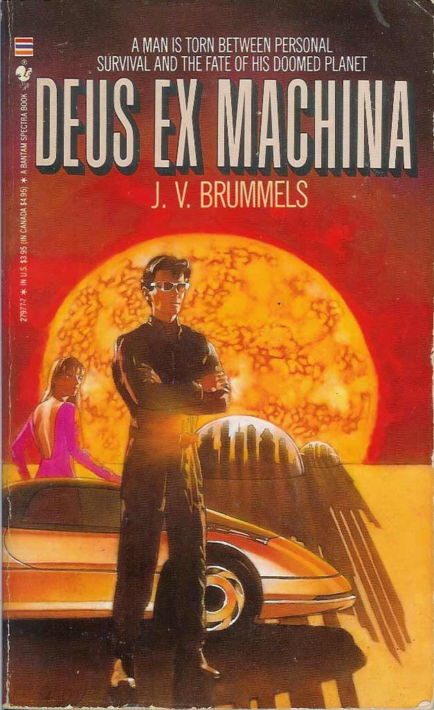
Another book added to the shelf below is a favorite book of mine called Deus Ex Machina, a lyrical soft sci-fi book about the end of the world by J.V. Brummels. It was written in 1989 and I've owned my copy since the early 1990's. It's one of those I can't help rereading every so often.

That I'm telling you that it's about the end of the world isn't a spoiler; it's mentioned in a intiguingly cryptic chronology at the front of the book. And the method of destruction isn't a secret either; it's depicted rather luridly in the cover art.

The real charm and romance of this book are the characters which, while somewhat simply drawn, seem real, and react authentically with thier environment in ways that get you to care. The backdrop of the Sun slowly exploding is captivating in its own way, as is the author's imagining of a post-modern near future where human civilization is doing its own slow imploding.

I recommend this book. I think it's one of the great overlooked bits of American literature

[talking_heads] Now This is How You Straddle a Fence

Michelle Malkin, one of the very worst pundits working (?) today, shows that she was against making personal remarks news-until she was for it.

The website The Talent Show has a post (which you can read here) which has her debating herself. It'd seem that she can't stand commentary on people she likes, even if it's positive, but if it's people she dosen't like-you know, miliary moms who've lost a son and are critical of the President-it's all in on her.

Referred by Eschaton, of course. I'm nowhere near this smart.

14 August 2005

[blog] Go Crack a Book. I Have Links.

Down at the way bottom of my links lists (which I notice is getting long indeed) I've added a couple of links to books that I've mentioned lately.

The first one, IllustratorCS2@work, is done by my friend Pariah S Burke, and it's the one that I've been doing tech editing on. It's almost been put to bed, one more bit left to do, and it'll be out some time in September.

I know this one is good, folks. If you're interested in Adobe CS2, you need this book.

The other one is Eugene E Snyder's book, Portland Names & Neighborhoods:Their Historic Origins, a book I've menched here before. Amazon.com actually seems to have a few copies, which is amazing for a book with a small press run, narrow interest, and only one printing-that one about 1979.

Despite this dating, it's still a book with huge value to those interested in Portland geographical history. Amazon says three copies are available. If you're interested in this but, my suggestion would be to jump on it.

Go all the way down to the bottom of the sidebar, where the words "Buy Books" are.

[Address_Nerd] Isaac Laquedem explains SW Ford Street Drive

A few iterations ago, in this post, a lively chat ensued in the comments about street names and the presence of such streets as SW Market Street Drive and SW Ford Street Drive got touched on.

These are very interesting names, fun to say, interesting looking on a street blade. SW Market Street Drive springs, somewhat indrectly, from the upper reaches of SW Market Street, hence the name. But what about SW Ford Street Drive? Examination of the map of Portland shows no such SW Ford Street.

Isaac Laquedem solves the conundrum for us.

Lay on, Professor:

The story behind SW Ford Street and why it isn't there any more goes back to 1925, when the Ford Street Bridge was replaced by the Vista Bridge. In 1892 when the subdivision of Ardmore was platted (it lies just to the west of Vista Avenue, between Vista and Douglas), Vista Avenue was shown on the plat as Ford Street and Ardmore Avenue was named Macleay Street.

When the current Vista Bridge was built, the old span was moved to Burlingame where it was pressed into service as the Terwilliger Bridge and spanned the gulch for another 60 years, until the current span was built.
Brillant follow, first class detective work. Props, all y'all, to Isaac.

13 August 2005

[metro_transit] C-Tran Service Reductions At A Glance

From the C-Tran Website:

• C-TRAN Service Reduced by 40 Percent;
• Weekend Service Eliminated;
• Commuter routes 114 and 173 Eliminated,
• All other commuter routes retained;
• Service to Camas/Washougal Eliminated;
• Service to Battle Ground Eliminated;
• Connector Service Eliminated;
• C-VAN Paratransit Service Boundaries Reduced;
• Service Day Ends at 8:00 p.m.;
• Passenger Service Office Hours Reduced.

Read the entire service reduction summary at the C-Tran website here.

If you're for C-Tran and you believe that the upcoming initiative ought to pass, now would be the time to get involved. There's a group of Clark County citizens, Save C-Tran (follow this link) that is devoted to explaining to their friends and neighbors how important transit is in Clark Country.

The election is 20 September-just a little over a month away. The clock is ticking.

12 August 2005

[metro_transit] Portlander hearts C-Tran!

A few iterations back, in this post, I outlined as much as I could find out about the service changes coming to C-Tran (the Clark County Washington public transportation district) as a result of sharply reduced funding and an upcoming proposition which, I imagine, is very much still up in the air.

Today, in my agora inbox, I found the following, from "Jason in Portland"

Hi, I'm glad to know I'm not the only person in Portland interested in Clark County, Washington's transit system!
Yes for jobs, yes for C-Tran!
That last line (yes for jobs, yes for C-Tran) seems a rallying cry.

Jason has a website here. He is an impassioned fan of C-Tran, even though he is a Portland resident. He has a very personal feeling about the future of C-Tran and transit fans ought to support him, I think.

Four stars. Sam-Bob says "Check it out!"

It's important to know what will happen in September if C-Tran doesn't get what it says it needs. It's on its knees right now. And not only will the service area and frequency be cut back sharply, late evening buses will end, as well as all weekend service.

I'm one who believes that, even if I don't take transit, I benefit indirectly from having it there. Transit's not a perfect solution, but it's better than not having it at all. Acquaintances from other towns usually give me rave reviews of our vibrant yet flawed TriMet. And MAX is just plain cool (in a few years, I'll be near a three-line nexus).

So, hey, Vancouver, here's something you guys probably can't understand-Portlanders who like and care about you...sincerely.

How cool is that?

Jason goes on the list.

10 August 2005

[geography] The Address Nerd Points You To Free City Maps..

...or, your Oregon taxes at work.

If the cities I prattle on about interest anybody enough to want a map of it, I'm pleased to let you know that the Oregon Department of Transportation produces street maps of every incorporated city in the State of Oregon, as well as several unincorporated locales.

You can go to the office in Salem, at 13th St NE and Marion, and buy reasonably priced hard copy maps, or go to thier website and download free PDFs of any of them. They also have GIS data for the taking.

They can be pretty large, so if you're on dial-up, there's a wait involved for some of them.

If you take it electronically, it ought to be free: you Oregonians paid for it, after all!
Here are your links:

Map Library home:
http://www.oregon.gov/ODOT/maps.shtml

City Maps home here. County Maps home here.

There are also statewide maps and rail maps. Fun stuff, and you can't beat the price.

[net_stuff] Wu-Tang!

Ever wonder what your name would be if you were part of the Clan?

Well, you might not have that fearsome kung fu (I have 10,000 fighting styles) but you can get your Wu-Tang Clan name here.

Peace OUT,
100-Watt Warlock

09 August 2005

[geography] The Address Nerd Gives You Street Signs From The Cultural District

Since I've covered nearly the whole of the general address scheme of Greater Portland (I almost have enough now to put it all in a Grand Unified Address Theory), I'd like to take a little side trip.

I give you street signs, another fascination of my early days. People who actually erect these signs call those signs that identify the streets blades, and so will I, from here on out.

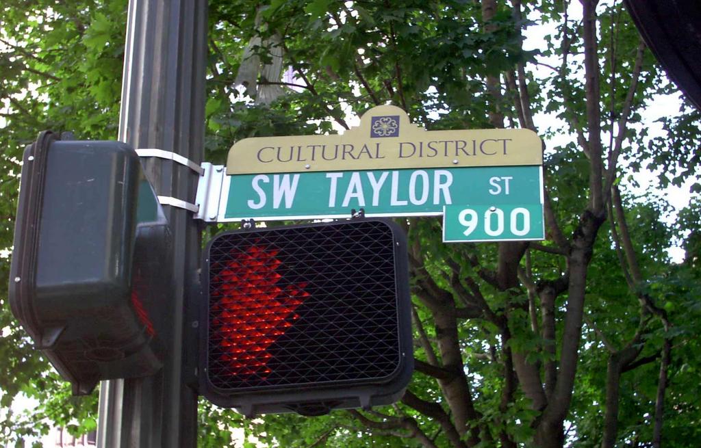
This photo of the SW Taylor Street sign (as it happens, at SW Broadway), amply illustrates the basic format for all street blades within the Portland city limits (ignoring the obvious attachments). Green, with bold letters for indentification, and the directional and name (SW TAYLOR) much larger than the street type, which is still centered for ease of readability (the eye follows the type from the large type to the small without extra effort). Since, in nearly every area of Portland, numbered avenues cross named streets, it's not necessary to quickly register that Taylor is a Street.

The basic format gives only basic information, however. To this end, the city sanctions a couple of attactments. The first and (so far as I'm concerned) most important, is the addition of a block-number tab to the basic sign. The one on this is "900" which, as I've before intimated, does not inidicate the 900 block of SW Taylor Street, but the 900 block of SW Broadway. Whether you are entering or leaving that block depends on the direction you're traveling–since SW Broadway is a one way street going south, if you're looking at this sign from a moving vehicle, you're entering the 900s. Or you better be. You'll get a big surprise...soon...if you're going north.

Have the block number on the sign is an important device; if one is unsure where they are but knows the city well enough, on main streets, all you need to do is glance at the sign, not inspect buildings along the street for addresses whose appearance cannot always be counted on. In neighborhoods away from main streets these tabs are usually not mounted; presumably by that time you're driving slowly enough that you can eyeball the address on the buildings.

(Quick parenthetical rule of thumb for downtown: Odd numbered Avenues are one-way southbound, even numbered avenues are one-way northbound. Count SW Broadway as 7th)

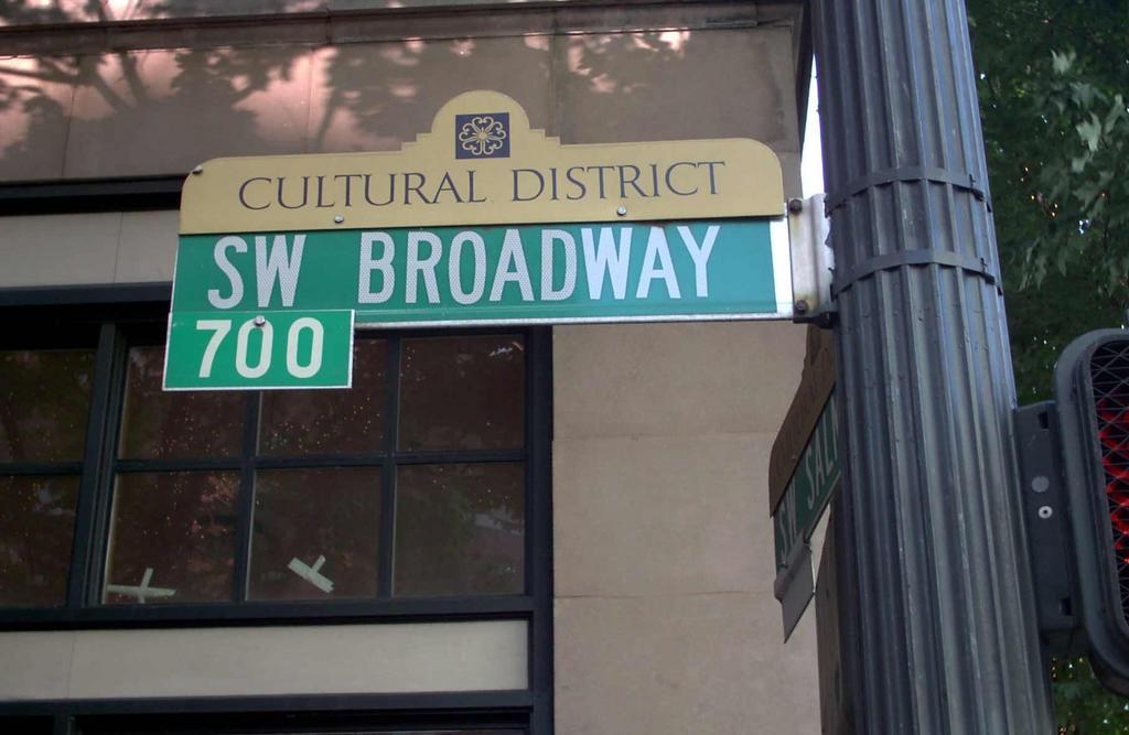
The other attachment is what I call a sign-topper. This is a fashion that has really caught on of late, which is designed to give identity-starved neighborhoods some sort of cohesion somehow, or at least some sense of neighborhood pride or brand-identity. I am of a mixed mind about these. Some of them are quite good, a couple are brilliant, many of them are bad. I plan on exploring this topic in the near future. A big minus is that they tend to displace the block number tab from its proper place (which is typically centered on the top blade), or makes it gone entirely.

Take a look at the blade for SW Broadway on the left there. The area of south downtown (call it south of about SW Salmon Street, and west from SW Broadway to the Stadium Freeway (I-405)) has been styled the "Cultural District"; Schnitzer Hall, Portland Center for the Performing Arts, Portland Art Museum, Oregon Historical Society, and Portland State University all are situate in this area. When attempting to communicate a perception of sophistication that would perforce pertain, an understated gold backs up a classical typeface. Good so far, but the reference to the patterned tile in the top center is rather unclear. It may be drawn from local architecture, but it's hard to say just what.

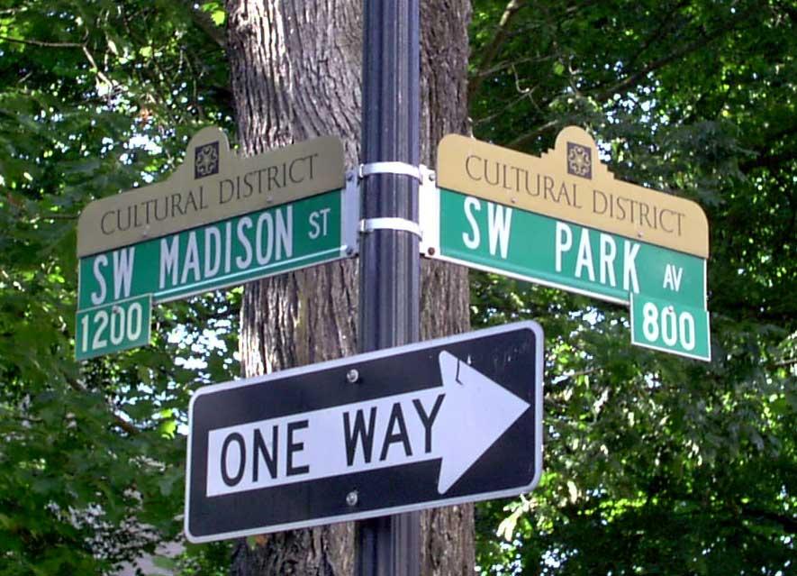
The last picture I'd like to share for now is a picture of the sign at the corner of SW Madison Street and Park Avenue. Numbered Avenues don't need block number tabs-since the hundred-block of the numbered Avenue begins with the number of that Avenue (18th Avenue defines the 1800s on the cross street)-they don't need them. When a named Street crosses a named Avenue, they have to get creative. Usually, though, this just means that the blade on the bottom has the tab displaced to one side or the other of the signpost, and usually hanging from the bottom edge. But when you have sign-toppers on the job, all tabs–if they're there–go to the bottom. Here we see the 800 block of SW Madison Street and the 1200 Block of SW Park Avenue.

Speaking of SW Park Avenue and SW Broadway, there's a couple of issues I like to touch on. Noticing the SW Broadway blade, notice how there isn't a street type on it? It's not "SW Broadway Avenue" (which would be thematically appropriate), but just "SW Broadway". That's a quirk about Portland that I've always been fond of. Moreover, down through the years, streets in town that are called "Way" have had that folded into the street name leaving the street typeless: NW Wardway, SE Reedway. Sadly, it does seem to be subject to slow replacement; I've seen "NE Broadway Street" replace "NE Broadway" and "SE Reedway Street" replace "SE Reedway". I lament this. It's a cute local quirk, and I think well enough should be left alone.

With respect to SW Park Avenue, there's a name change on part of it. North of the Arlington Club/Paramount Hotel block (about SW Salmon Street) the street's character changes. South of Burnside, SW Park Avenue and SW 9th Avenue define a very narrow east-west block, a legacy from Portland's early days, when that strip was a wide-open area called "The Boulevard". In the areas that were commerically developed, the streets carry the names just mentioned, but once south of Salmon and the Park Blocks take up, both streets carry the name "SW Park Avenue"...leaving the name "SW 9th Avenue" behind.

[or_politics] Rep. Merkley Rings Minnis Up

In this post over at Oregon House Democrats, Rep. Jeff Merkley, my State Representative, lays it out for you; how Speaker Minnis has turned this last Legislature into a cafeteria for Big Money where you-the average Oregonian-got mostly worked over (title loans, anyone?) when they thought about you at all.

Get used to it...as long as Republicans are in power, this is the way it'll be.

Oregon House Democrats gets added to my list.

06 August 2005

[blog, linkage] It's Not a Tumah, It's Not a Tumah At Ohll: It's Jim

Link love is introducing me to so many people...

After I looked about at stan, I saw a link to a 'blog simply titled it's jim, established by the mononomially-tagged Jim. Started reading.

The man is funny. Staccato shots of personal life delivered by someone who enjoys roadgeeking and has a viewpoint on life that's absurd and a delivery that's about half Steve Martin and half Steven Wright.

He lives in Saint Louis. Has a doggie named Rooty. Makes me laugh out loud.

Four Stars: Sam-Bob says "Check it out". Especially the archives.


And, on a personal note, this heat is starting to make me feel ill-I have a night job and must attempt to sleep during the day. So the posting and 'Nerding might fall off just a little. But I will try to keep it in.

Thanks for reading me, you guys.

05 August 2005

[geography] The Address Nerd Lays Eastern Multnomah and Clackamas Counties on You

Welcome back. In my last discourse I mentioned I was working my way around the center of the Greater Portland area clockwise. This means our next destination, as we cross the Mighty Columbia going south, is eastern Multnomah County, followed by Clackamas.

Here's what I know.

Eastern Multnomah County

As one travels east, past Gresham, Fairview, and Troutdale, the metagrid proceeds faithfully to the crest of the Cascades. Multnomah, for its being a narrow bit of land, as all Valley counties that exist on the east side of the great Willamette, terminate at the crest of the Cascades.

The division line, NE/SE, on the ground, follows Burnside Street faithfully eastbound until you get to 181st Avenue, in the Rockwood area. Burnside then begins a curve south, leaving the baseline. It defines quite a graceful curve along the north and east areas of Gresham, to become SE Burnside Road, then NW Burnside Road as we cross into the Gresham address grid (at about the 20200 Block), NE Burnside Road as we cross the N Main Avenue address baseline for Gresham, then SE Burnside Road as the SE 1st Street baseline is crossed, the road name finally terminating at the big Burnside/E Powell Blvd/Hwy 26 junction in eastern Gresham.

From 181st east to the edge, then, the division line becomes virtual rather than actual but continues its straight surveyed course. The neighborhood centering on SE 223rd Avenue and Stark Street, in north central Gresham (historically known at Twelvemile), shows how it's dealt with, proceeding south: NE Couch Street, then SE Ankeny, SE Oak, and SE Stark Street. The addresses simply descend to zero and start going up again, and the directionals go from NE to SE with no dividing E street. This is very similar to Washington County in the Aloha area, where SW gives way to NW in many areas without the extension of a dividing street.

The procession is interrupted as one proceeds east by the internal address grids of Troutdale and Gresham (that's for another post), and take up again as you cross the Sandy River. The Springdale and Corbett areas have a scattering of numbered avenues (NE 366th Avenue, for example) but, in this area, numbers give up after that. The NE/SE directional continue for wherever there are developed roads, however. The streets serving the Warren area-that district where the Historic Columbia River Highway touches I-84 east of Troutdale-are prefixed NE, as are few roads on the Oregon side of the Columbia River at Bonneville Dam. Address numbers themselves get correspondingly huge, north of 50000.

Clackamas County


Clackamas County wears two systems. They still decrease as one moves toward Portland, at least as one goes north.

Directionally, Clackamas County breaks along a line formed by the Willamette and Clackamas rivers. This divides the County into two uneven chunks.

The north part, that part which contains West Linn, Gladstone, Milwaukie, Happy Valley, Damascus, Sandy, and Government Camp, inherits the address progression of the areas north of it, and in many areas, notably Milwaukie, Damascus, Boring, Sandy and the area between Wilsonville and West Linn, also inherits the numbered Avenue sequence. Downtown Milwaukie contains a SE 21st Avenue, only three blocks from the Willamette, and the road along the Willamette Meridian, which historically was called Meridian Road before development reached out that far (and from which Meridian Park Hospital takes its name) is known today as SW 65th Avenue almost all the way into Wilsonville. The progression of numbered avenues into the Sandy area has already been documented.

The Willamette continues its SE-ward meander south of downtown Lake Oswego. The older parts of Lake O, however, form an interruption in the pattern-it has retained its historic pattern. South of this, outside the city limits and in the North Stafford area, the metagrid reasserts with its 20-to-the-mile blocking. The line that separated zero-hundreds in Portland proper continues, but in the area between that line and West Linn, a new prefix is named: South. To the left of this, SW obtains.

Meanwhile, on the east side, the address progression maintains as an extension of the Portland system. Somwhere east of SE 502nd Avenue, a soft boundary is passed, and all roads have the simplex directional East. Addresses along Highway 26 in the Welches area run past the 68000s, with addresses on the cross streets getting high-we've come quite a bit south-an address such as 68200 E Highway 26 or 24500 E Arrah Wanna Blvd are possible.

Yes, there really is a road out in Wemme/Welches called E Arrah Wanna Blvd. I just love that name.

The practical end of this is Government Camp. Held gridiron-true by township, range, and section lines, east-west addresses reach (some would think) absurdly high ranges (but I love this stuff). The section of E Government Camp Loop going through the GC commercial district wear address in the 88200 to 90200 range. A 92200 Block is defined about one mile east of where Government Camp Loop rejoins Highway 26 going east, but is not likely to be developed as such. North-south addresses in the small cross streets have similarly respectable ranges, about 30500-31000. All streets are still prefixed E.

Turning our attention south of the Clackamas-Willamette line, we find the directional on all roads is S (S Springwater Road, S Hwy 99E (or McLoughlin Blvd)), and a surprising thing; though addresses decrease to the north and west, as we might expect, the origin doesn't seem to be the center of Portland, nor does it seem to be obvious, nor does it even seem to be contained in the system.

The lowest possible address in the South area in the north-south range is the 14000s, this in a near oxbow of the Clackamas River near the 212/224 fork; the lowest possible in the east-west range is the 4000 block, where S Elliott Road crosses the Pudding River, just off S Meridian Road (which follows very close to the Willamette Meridian) from a junction about a mile south from Meridian Road's junction with State Highway 211 (the road that connects Molalla and Woodburn).

But that's not all. The most suprising observation about this area is that address run 10 standard 100-number address blocks to the mile-not 20 as true throughout the rest of the metropolitan area.

Since the addresses align along section lines it should be simple-in principle-to find where zero would be. But, alas, my records are incomplete and my time is up. This will have to wait for another time.

[pdx_life, metro_transit] Saint Johns Bridge To Reopen, TriMet to Saint Johns to Resume Normal Service

According to The Oregonian, the majestic old Saint Johns Bridge, proud recipient of The Most Beautiful Suspension Bridge In The World, By God Award (made by this 'blog, right now) is set to open to 24 hour 7 day full traffic access as of 0500 Saturday morning-or, just less than 12 hours from the time of this post.

While it's unclear exactly what remains to do as to construction finishing and cleanup (the article did not specifically mention), all four lanes of traffic and all pedestrian access will be restored at that time. This is good news for anyone who'd rather use N.W. Saint Helens Road (US 30) to get out to St Johns, anyone in greater Linnton whose tired to death of having to go all the way down to the Fremont Bridge (beautiful as that is) just to get across the river, and anyone using TriMet.

In this Rider Alert, TriMet has announced that regular service is also returning to the Saint Johns Bridge. Since work on the bridge commenced, Line 17-St Johns has had to terminate service over the bridge at 8 PM, when the bridge closed for nightly work. With it open 24 hours, all normal service will resume using the bridge, which should save Line 17 riders about seven minutes over the detour times.

04 August 2005

[design] Designer Seeking Work

One thing I've forgotten to mench lately is that my long course of instruction at PCC is at last concluded, and I'm o-fish-o-ly a degree-holding Graphic Designer.

Yes, I know. w00t and all that.

My next project is finding a job. Right now I'm open to a lot-I can freelance, know QuarkXPress (4-6.5), Adobe InDesign and Creative Suite (up to CS2-got a little beta testing on that), I can news design (see my portfolio online), have done the Sierra Club's Columbia Overlook (and am starting on the next one real soon), and can edit (did technical editing for this here book that's about to be released on IllustratorCS2) . I use Mac OS X regularly but also do Windows (I'm a snob but hardly a religious extremist).

Yes, I check craigslist (who doesn't?).

Second place prize be getting a look around inside some design departments. I'd really like to get an informational meeting with someone at The Oregonian or the Portland Tribune (I've applied to Community Newspapers but nobody's replied) but am still trying to figure out who to talk to about that.

[or_politics] I Heart My State Rep

Jeff Merkley has my vote as long as he wants it.

Read all about it at blueoregon.

...and a further comment here, where Rep. Peter Buckley (D-Ashland), steps up to the plate.

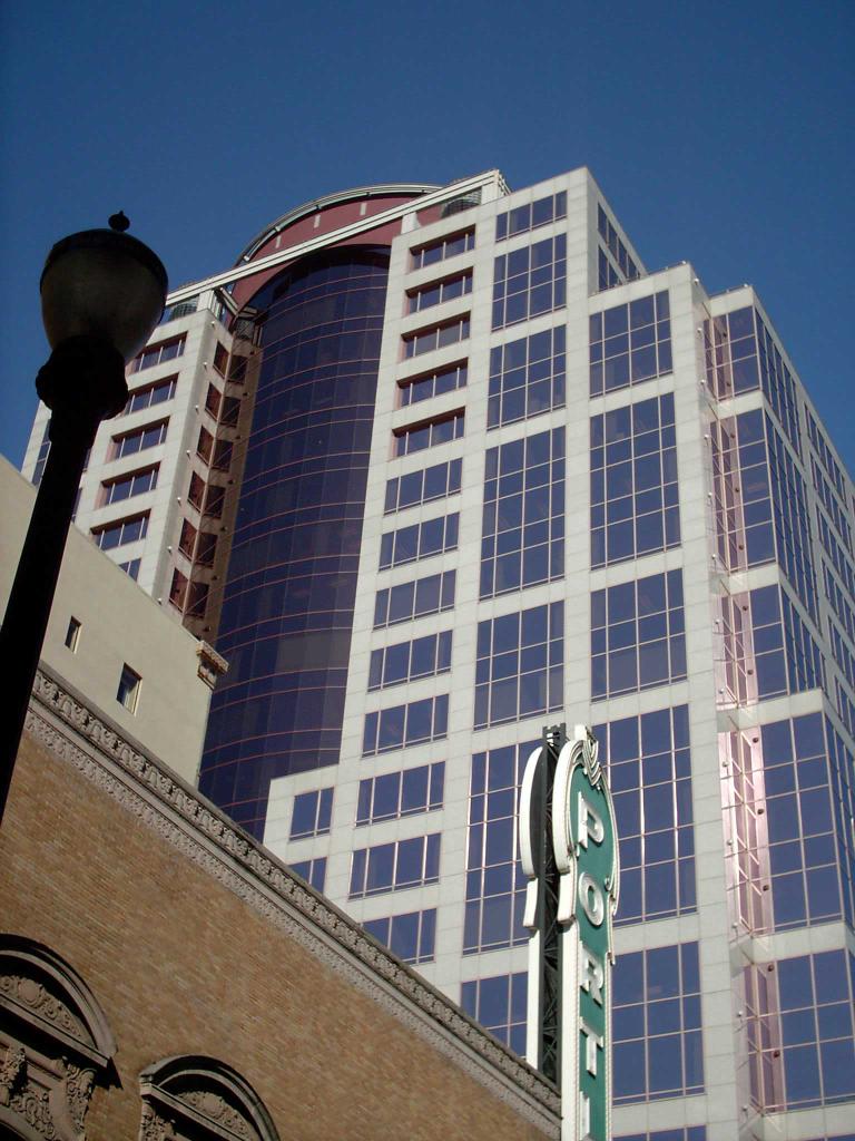
[pdx_life] 1000 SW Broadway, Low Angle POV

Another view from the sojourn through the Cultural District that me and The Wife[tm] took yesterday:


The 1000 SW Broadway Building, taken from a point about midblock on SW Main Street between SW Broadway and SW Park Avenue. The building in front is, of course, Schnitzer Hall, which, given the limited scope of the camera's visual field, makes an intriguing counterpoint to the blue sky above.

I tell you, when you look at Portland from this angle, it doesn't seem like such a small town anymore, do it?

03 August 2005

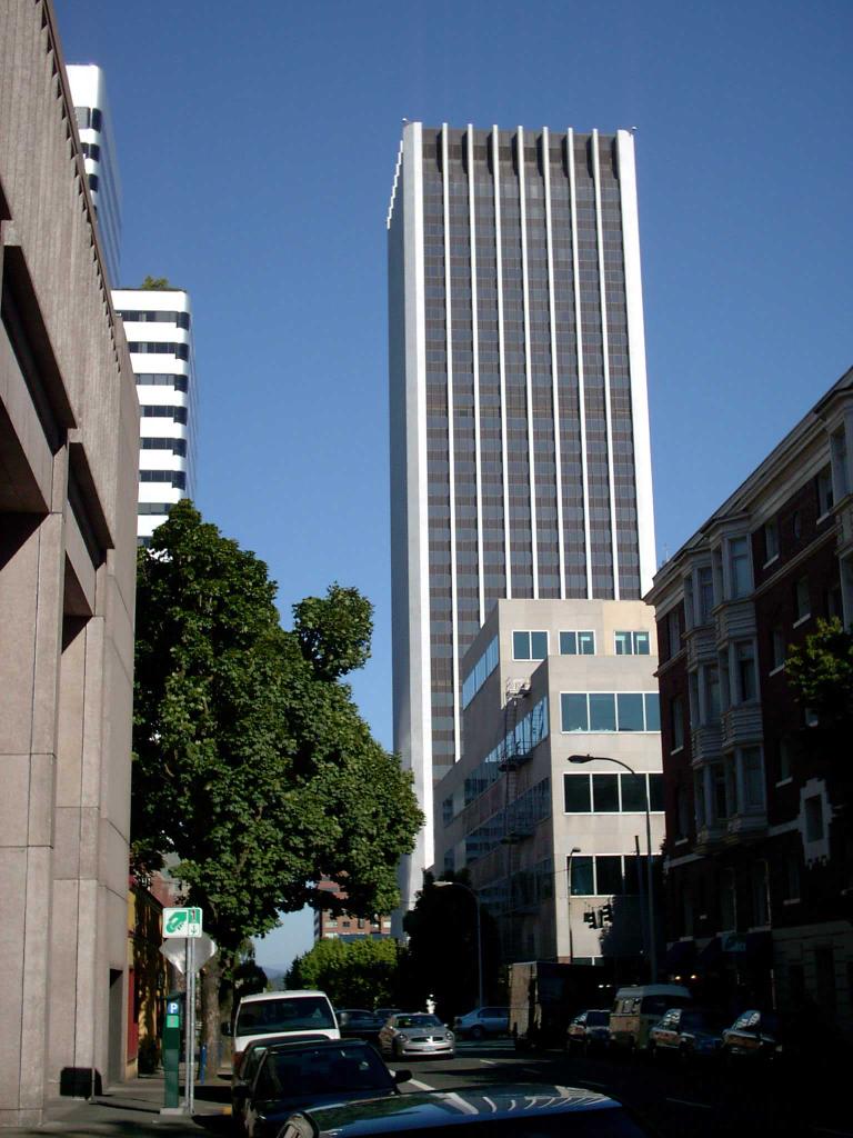
[pdx_life] A View Down SW Columbia Street

Looking east on SW Columbia Street from SW Park Avenue, about 5 PM yesterday:


I love the First National Bank Building First Interstate Center Wells Fargo Bank Building. It was Oregon's first Real Big Building, and, at 40 floors, is still a teeny bit taller than the newer, 42-story, UNICO/US Bancorp Tower, fourteen blocks north.

While I'm not going to say how old I am, I will let on that I remember when there was a First National Bank of Oregon.

PS: The shorter, blocky building directly in front of the tower, the one with the horizontal strips of windows, is the headquarters of The Oregonian.

[geography] The Address Nerd is Hard At Work

More postings are in planning, of course. At this point, I'm ready to swing around into eastern Multnomah and Clackamas County, but I want to make sure of my angle of attack first.

I have also set my sights on another project. Yesterday me and The Wife[tm] were out taking piccies of signs. That's all I'm sayin' at the present time.

R and D is hard at work, yo.

[blog] Inbound Love

I noticed that I got a few new links in this week. As always, I'm grateful for them. Just like the other people who've linked to me (Mike, Pril, homopoliticogeek, Schlockstar), they are also interesting and intriguing places to visit. All now have reciprocal love from my own list of links.

Stan is one. He announced his presence with a comment to an Address Nerd discourse which happened to mention Biddy McGraw's. I'm happy to provide readers with what they seek. In following the path back to his own 'blog I found that he does an net.comic strip (Joel & Steve:The Road Trip Comic Strip) which I am now getting caught up on. A link is available from his 'blog. The 'blog itself is a highly interesting personal chronicle.

I got a link from Isaac Laquedem. His is a curmudgeonly voice with quite a bit of knowing; his tagline explains it succinctly with a cranky sort of humor. I've not read him long enough to figure out how congruent we are, but I sense we are kindred spirits. I'm with him on this post
about Atkins (don't get The Wife[tm] started about "Atkins fuzzy math") though. Thanks, Isaac.

And I've also somehow found my way as a link on a blog of regional scope called Subduction Zone. It seems to be concerned with politics and public policy on the Upper Left Coast in general, and makes for interesting reading with takes on public transportation, regional lawmaking, and such. The 'ed itor' has seen fit to include me next to some cool.kids, and I am grateful.

02 August 2005

[blog] Dept. Of Corrections Dept.

In my last, I cited Loren Bacall as having played with Bogart in Casablanca.

As a commenter succinctly pointed out, she was most certainly not in Casablanca. That was just me getting ahead of myself; I've seen this movie several times. As The Wife[tm] reminded me, it was Joan Collins Farrah Fawcett Irene Cara that chick who played in Flashdance Ingrid Bergman.

The Times regrets the error, especially since I made such a dumb one in such a visible place.

01 August 2005

[movies] Bacall Speak

You listen.

Lauren Bacall correctly calls "get over yourself" on Tom Cruise on his recent public behavior.

Now, don't get me wrong. Despite being conflicted over how Tom uses his public persona to flog his religious views to the world, I've always enjoeyed him as an actor. His performance in War of the Worlds makes for good viewing.

There's a very skilled actor at the middle of all that bizarrity. But the bizarrity is making him a laughingstock.

Famously, she also criticised an entertainment reporter for anointing Nicole Kidman a "legend" in a question an interviewer asked her about acting with her, criticism which Kidman accepted with grace and equanimity.

Curmudgeonly? Maybe. But, as far as I'm concerned, if anyone is qualified to judge who a legend is, if the woman who played with Bogart in Casablanca, To Have And Have Not, and Key Largo can't judge, then nobody can.

And you, dear reader aren't qualified to judge Bacall unless you've seen them.

Consider it your film school homework.

(NB:Original story courtesy Yahoo! News)

(Editor's Note, 2 Aug 2005: As it happens, Bacall was not in Casablanca. It was Ingrid Bergman, of course.)

30 July 2005

[cosmos] Have They At Last Found Persephone?

Astronomers think they have found the 10th rock from the Sun. Naturally there is still a great deal of argument about this, but there seems to be reliable word that a body at least 1.5 times the size of Pluto has been found in the Kuiper Belt. It is estimated at 2,100 miles in diameter, and revolves around Sol at 97 a.u., about three times the distance out than Pluto (and a.u., or astronomical unit, is taken as the distance from the Earth to the Sun). Its orbit is inclined a surprising 45 degrees from the plane of our own, which is one reason its been so hard to find.

Yahoo sums up the breaking news from Space.com in this story.

Persephone is the name sf writers have floated from time to time as the next major planet to be found out from Pluto, if one should exist. It falls neatly into our theme of naming planets for the Greek pantheon; she was queen of the underworld in the Greek mythos and formed the mythological basis for the changing of the seasons, as she spent six months in the underworld and six months up top. James Blish, in the Cities In Flight cycle, called this notional planet by its Roman name, Proserpina.

[geography] The Address Nerd Gives You A Handy Chart

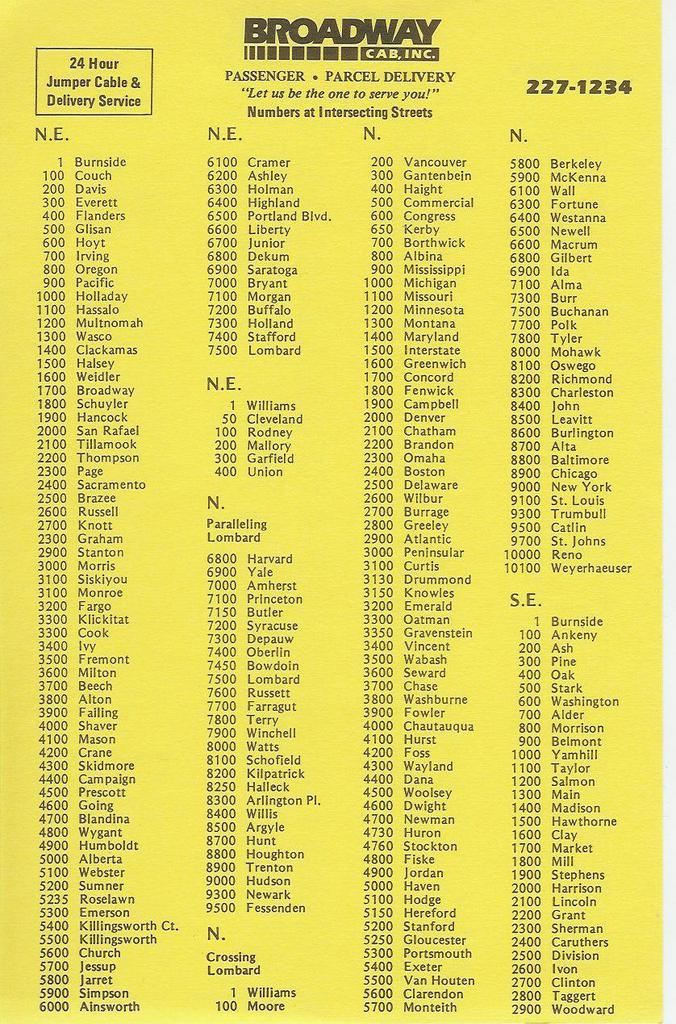
The thumbnails at left and below should click and expand into a handy dandy little guide to help you get around our fair Rose City.

It is referred to, somewhat unfortunately, as the cheat sheet. Broadway drivers carry them. I believe Radio Cab prints thier own version.

It's no secret internal document or salacious peek into the world of the cab driver. All it is, is a list of streets in Portland, and thier 'block numbers'. It is a bare-bones index listing of streets, a basic textual description of the city's skeletal structure.

To understand how to communicate with this list, meditate well on the boldface subtitle below the Broadway Cab logo: Numbers at Intersecting Streets.

Take side one, the section headed "N.E". This list starts with 1 Burnside, then continues 100 Couch, 200 Davis, 300 Everett, 400 Flanders, 500 Glisan all the way to 7500 Lombard. Now picture yourself heading north on NE Grand Avenue from Burnside. You've just crossed the intersection of NE Davis Street. You're going north, and if you've paid attention to the lessons so far, you know numbers are increasing, therefore, you know you're entering the 200s on NE Grand. If you're traveling toward a baseline, say southbound on NE MLK Jr Blvd, the numbers go down; if you're crossing NE Davis going south on MLK, you know now you are leaving the 200s on NE MLK.

The whole thing is just that simple. Now you know how to interpret those block number tabs on the street sign: when you're at NE Glisan and 60th, say in front of Biddy McGraw's, and you're telling someone where you are, you, dear God, don't say you're at "500 NE Glisan St". You are now enlightened. Carry this gem whereever you go in Portland, Glisanhopper, and don't get lost.

Even though the layout and design are rather straightforward, there are a few points worth noting. For instance, the NE list ends at 7500-Lombard, which as can be easily seen from the map, is hardly the edge of the city. For streets north of Lombard, check the section labelled "N" and subtitled "Parallelling Lombard". Find 7500-Lombard in the list–a few of the streets from 7600-Russett north have NE counterparts. As for the streets south of Lombard and parallel, most of those streets are unique to the peninsula area. However, NE streets have N counterparts as far east as Greeley Avenue, so the NE block numbers apply there.

Just after the end of the long NE list is a shorter NE list with 5 items–1-Williams, 50-Cleveland, 100-Rodney, 200-Mallory, 300-Garfield, 400-Union. These are actually named Avenues. From the Rose Quarter area north to Columbia Blvd, instead of numbers, the Avenues in that area have names. These are thier intersecting block numbers.

The N (Crossing Lombard) list serves the Peninsula as well as areas south–out to about Interstate, N named Avenues extend as far south as the Rose Quarter (notably Williams and Vancouver).

Even Zero Hundreds are accounted for-but that list is very short as well, leaving off at 0600-Moody.

The list, then, isn't all-inclusive. It includes the straight streets only (a listing including all the curvy streets in Healy Heights, Council Crest, etc, would be a book, providing it could be so designed as to communicate clearly). This card is a good shorthand reminder if you know the city well, a map companion if you dont.

Two other areas deserve mention. The last two sections on Side Two begin with the heading "E. & W. Streets Crossing Sandy (and numbers on N & S Aves. At Sandy)" and "E. & W. Streets Crossing Foster (and numbers on N & S Aves. at Foster)". This bit of information design has always struck me as unassuming brilliance. Each has a list of names and numbers formatted thus: 16 Davis - 200 (for the Sandy list). You read it thus:

As you are travelling on Sandy Blvd and cross NE 16th Avenue, you are also crossing NE Davis Street, which is the 200 block on 16th. Similarly, in the Foster list, 63 Holgate - 4500 means that as you go down Foster Road and pass SE 63rd Avenue, you are also crossing SE Holgate Blvd, which is the 4500 Block of 63rd.

Nifty, eh?

The cards might be available from a cab driver, or you can probably phone Broadway Cab and ask them to send you one. If you don't know what Broadway Cab's phone number is, you should get out more. Here's a challenge: CApitol7-1234. Figure out what goes in place of the C and the A. Don't forget the area code.

Please also note, while the Broadway Cab logo is included on these cards this is not to be construed as an endorsement or opinion, one way or the other, on Broadway Cab.

29 July 2005

[geography] The Address Nerd Visits Clark County Cities

This is essentially part 2 of this post.

In that post I did a sort of grand tour of Washington's Clark County, commenting on the address baselines definition, the Vancouver rationale, and how it extends into the county and that even though the naming systems seem different the county grid is actually an extension of the city grid.

Clark County has a handful of outlying cities: Ridgefield, La Center, Battle Ground, Yacolt, Washougal, and Camas. As distinct from many cities in the Portland metagrid, each one of these cities has thier own internal address and street name systems, with no exception.

Ridgefield

Ridgefield is located along the Lake River, a "yazoo" type that forms the outflow from Vancouver Lake to the Columbia River (which it itself joins just northwest of the town, near its confluence with the Lewis River at the NW corner of Clark County). It's reachable by car off I-5 exit 14, which is actually about three miles east of the center of town.

For a long time, Ridgefield's complete corporate area was a wedge-shaped bit of land less than a mile square straddling the Willamette Meridian in Township 4 North. The address and street name structure has always been simple. North-south numbed avenues increase east from the railroad which runs along Lake River, and Pioneer Street formed the baseline dividing the north from the south. Numbered avenues have simplex directions as prefixes (N 4th Ave, S 9th Ave), and Pioneer Street became NW 269th St at the city limits, connecting town to freeway.

Within the last 4 years, Ridgefield increased its area on the ground many times. From a small patch of ground three miles west of I-5, the city has expanded to extend one mile east of it, and extended about a mile and a half south of Pioneer Street to encompass the Ridgefield High School Campus (at the intersection of what had been NW Hillhurst Road and NW Royle Road). Most of this new city land lays undeveloped as of yet, but urbanization can't be too far down the road.

With annexation of the new city land, all county-named roads within that area have been brought into the Ridgefield grid. In a small version of the Clark County method, the names of the older section of town have been preserved but the names of new streets in former county lands have been dubbed with numbers. Avenues, Courts and places increase to the east, Streets, Ways, and Circles increase north and south from Pioneer. Roads that do not follow cardinal directsions retain word-names, the names they had as county roads, prefixed N or S as appropriate.

The result is very high numbered streets in a small town, which is a strange thing to see. For instance, what was called NW 31st Avenue is now known as N and S 45th Ave-this is between Exit 14 and central Ridgefield , less than 1 mile west of I-5. The former NW 269th St has been renamed to Pioneer Street all the way out. Just west of I-5 traffic is diverted down S 65th Avenue (renamed from Clark County NW 11th Avenue) onto S 5th Street (formerly NW 264th Street) which intersects S 77th Place and S 78th Place before it ends at Clark County's NE 10th Avenue (which, since it is on the city-county boundary, has apparently not been renamed to S 85th Avenue, which would be its logical city name).

Most of this area remains farmland, which means that a map is useful to see the pattern. The new streets are spaced fairly far apart, and the pattern may not be terribly obvious on the ground.

La Center

La Center is just a few miles northeast from Ridgefield, and is reachable from I-5 exit 16. The road leading into it was once called NW 319th Street until it started to curve to enter the town. This has since been changed, and NW 319th Street has inherited the name NW La Center Road for its entirety east from I-5 into town.

One enters La Center proper after crossing the bridge over the East Fork Lewis River, approximately 1.5 miles off the freeway. The main road (the old Pacific Highway 99) nicks off a slice of the west part of town and slides quickly out enroute to the Lewis River bridge into Woodland.

As many Clark County cities have, La Center has grown too, though not as much as others. It has grown by about a factor of two, however, and has added in enough new land to plat a large new subdivision on the towns northeast side.

Generally speaking, numbered streets cross named streets. East of the dividing line, Aspen Street, streets name in alphabetical order after trees: Birch, Cedar, Dogwood, Elm. West of Aspen the streets are lettered: A, B (Pacific Hwy), D, E, F, G. Not every street was developed on this side, and the pattern breaks down fairly quickly.

Observation of the map shows two different textures to town. South of 10th Street, there is a regular gridiron, moreover, the west is at a steeper tilt than the east. North of 10th Street lays the big subdivision plat, easily distinguishable by its lazy curves and loops. The numbering pattern is logically continued even if named streets are not; the highest-order numbered street is E 18th Street, adjacent the north city limits.

The 10th Street transition line is important for another reason; 10th Street is laid out along an important line in the Public Lands Survey for this region, the First Standard Parallel North. A complete description of this is a bit off topic, but quickly, this line is necessary because the Survey is a flat grid laid out on a big ball. As you go north, those Range lines tend to converge. The east-west spacing is resurveyed at the Standard Parallels, which usually space off at 5 townships north and south of the baseline.

The Town of Yacolt

This is perhaps the most backwoods corporation in the county. You reach it by going out SR 503 (NE Lewisville Hwy) to Rock Creek Rd/Lucia Falls Road, which by what I understand is a very picturesque drive, will lead you into Yacolt from the south. No state highways lead to Yacolt. It is about twelve miles exactly east of La Center along the First Standard Parallel North.

Of all the cities in Clark County Yacolt's growth has been the most modest growth-almost none, in terms of territory. Its city limits have changed very little in the last 10-15 years.

And, in contravention of the urge of all cities in this area which strive to have some sort of system of numbered streets and avenues, Yacolt has none. N-S avenues cross E-W streets, but everything has a name, either proper names (Wilson, Jones), local landmarks (Amboy, Twin Falls) or functional names (Railroad). The divisional system is similarly simple, with simplex directional prefixes of N, W, E, and S based on the divisional streets of Railroad Avenue and Jones Street. Railroad Avenue runs NNW-SSE, at a slant, but the spread of the town is limited enough that this doesn't become a logical house numbering issue.

East and West Yacolt Road is laid out on the First Standard Parallel North, meaning it lines up exactly with 10th Street in La Center.

Battle Ground

This is another quadranted town with numbered Avenues running N-S cross numbered Streets running E-W.

It was not always thus. Ten or fifteen years ago, when the town had less area and less population, named Avenues crossed numbered streets. at some time during the last five years or so, the decison was made to toss all street names in the dustbin in favor of numbers, with just a handful of exceptions (notably, Clark Avenue, Grace Avenue and Fairgrounds Avenue; Rasmussen Blvd and Scotton Way in the south part of town, Onsdorff Blvd in the north).

The dividing streets are still N and S Parkway Avenue and E and W Main Street. they simply divide the town into duplex directionals (NW, SW, NE, SE) which are street name prefixes. The highest-order numbers in town are NW 29th Ave on the west, NW 24th Street on the north, NE 20th Avenue (off county's NE Heisson Road/229th Avenue) on the east, and SW and SE 18th Street, intersecting South Parkway Avenue just north of that street name's termination at NE 199th Street-Battle Ground's south end.

State Route 502 comes into town from the west end to become West Main Street: State Route 503-Battleground's direct connection to the I-205/Fourth Plain/Vancouver Mall area-comes into town from the south with the County name of NE 122nd Avenue and leaves town as NE Lewisville Highway, but while inside the Battle Ground city limits is known as NW and SW 10th Avenue.

Camas and Washougal

Camas has grown prodigiously on the ground much as Vancouver and Ridgefield have. From a modestly-sized town in the 80's that pretty much hugged the Columbia right bank it has exploded up the bluff to become a large wedge-shaped piece of land which now extends along the whole of the south shore of Lacamas Lake, and whose city boundary extends north of County's SE 1st Street-some four miles north of the river.

New development in the annexed areas has been named and numbered as an extension of the city's original grid.

The center of Camas is interesting because it sits at such a severe angle to the rest of the city. Established on a relatively level bit of land immediately north of where the Washougal River enters the Columbia, it runs at nearly a 45 degree angle from the cardinal. So great this angle is that, at the east end of the old town, NE 6th Avenue nearly intersects NE 19th Avenue, which is extended eastward from the cardinally aligned streets on the bluff overlooking the older part of town.

Regardless, this skewed grid forms the basis of the Camas addressing and numbering system. East-west numbered avenues intersect named north-south streets arranged alphabetically. The baseline running east is 1st Avenue, the baseline running North is Division Street.

A look at the map brings a notable feature out-there are a great many geographical discontinuities which make the Camas system a matter of logic and design. The skewed old town I already mentioned; north of 7th Avenue the bluff rises and the streets straighten out, and on the west end of city center the paper mill (what is it these days, James River still? I go back far enough that I still think of it as Crown-Z) prevents 1st Avenue and Division Street from physically meeting. Washougal River cuts off a tongue of land on the southeast side, and the system as a whole seems to preclude any SW prefixed addresses at all. But the system was established along those baselines, and the planning has been admirable consistent along those lines.

The baselines of Division Street and 1st Avenue logically divide the space into four quadrants, duplex directional, NW/SW/NE/SE , prefixed (the SW is dubious, as I mentioned, and I'll detail it presently). The geographically isolated SE section's name is determined by virtually extending East 1st Avenue along the Washougal River and probably estimating what those streets would be if something was physically extended from the center of town. West of city center all land is NW except for a sliver of land between State Route 14 and the Camas Slough shore, where a small district of land is prefixed SW and numbers increase from SR 14 toward the river. NW 6th Avenue crosses into this area and becomes SW 6th Avenue.

Because of the geographical problems inherent in the layout, following along with a map is recommended, if not required.

Camas and Washougal link up on Camas's east end like Camas is docking with Washougal. The center of Washougal is a reguarly gridded area about 1/2 mile east of where the two cities abut. The address and street name system of Washougal is essentially based on the easternmost point of Washougal south of the Washougal River, where you can find 1st Street. Thus, the historic central section of Washougal starts with 9th Street and extends east to 22nd Street.

Numbered streets progress west to east, lettered streets south to north. There are no directionals in the original city area, which is the part of the bar of land between the Columbia and Washougal Rivers not in Camas.

Since Washougal has grown, however, it's sprawled a little south (the floodplain of the Columbia provides an area for industrial growth; the area north of SR 14 and east of 32nd Street has provided room for residential growth. Latterly, growth has also included land north of the Washougal River and west toward Camas.

These extensions have logical extensions as appropriate. Any street south of A has a name but and a directional of S (S Ford St, S Index St), and any numbered street extending south of A is similarly prefixed (S 32nd Street). The geographic pocket north of the Washougal River has street names and numbers and addresses logically extended but evething in this area (just off Washougal River Road) is prefixed N (N M Street, N 24th Street). Even more interesting, the area of Washougal north of the river and west of a logically defined notional 1st Street extension north of Washougal River is prefixed West (an actual 1st street wouldn't quite line up correctly). The extent of this developemnt is a small subdivision off NE Crown Road (reachable from NE 3rd Street in Camas) with street names such as West Lookout Ridge Dr and W Y Street, W Z Street, and West 9th and 10th Streets.

The extension of Washougal east and north has a few named streets but largely extends the scheme of numbers and letters established in the original areas of the city. The highest-order numbered street I can find currently in Washougal is 57th Street.