
 The picture you see on the right at the top here sits at the entry to one of the smallest and the most singular State Park in all of Oregon or Washington: Willamette Stone State Park.
For those who missed my pontificating on just what the Willamette Stone is, here's a quick recap: All real estate surveying in both Oregon and Washington references a single initial point of what is called the Public Lands Survey System. This initial point (and there are many of them for various regions of the US, this one governs Oregon and Washington only) marks the intersection of a base line (running E-W) and a meridian (running N-S) from which 6-mile-square townships are measured, tierned in townships north and south and ranges east and west (this system is sometimes called township-and-range). These townships are further broken down into 1-mile-square sections. This system, used throughout the west from its various bases, allowed the government to determine who owned what, where. All surveyed real estate, from Boundary Point in Washington to the driest, emptiest corner of Malheur County, relates to this point.
It's in Portland's West Hills, in approximately the 200 Block of NW Skyline Blvd, and it can easily be visited. The wayside is a wide area on the left as you go outward from the city center and is easily missed (it's right across from a house addressed 220 NW Skyline Blvd (I only provide this for reference, don't bother the nice people there, okay?)). From the roadside an asphalt trail leads down what becomes a bit of a steep slope. Stop at the entry and look on the right for a sign that explains all about the Stone and why it is where it is.
 Turns out it started as a wood stake. Who knew?
The walk down the hill is nice but does get steep. If you're easily winded, take it slow and easy, and you'll get there...it's not quite two city blocks. What is magnificent about the park is that even though it is quite small, maybe 200 feet wide at its widest point near the entry at Skyline Blvd, there's been enough trees left that one can imagine what it must have been like when the first surveyors went up there to drive that stake. But why there?
I cut down the graphic for the sign pretty small and it probably can't be read, so here it is: the initial point was put there so that the Willamette Base Line should remain south of the Columbia River (closest it gets is out at Corbett, where it's scarcely a mile south of the river) and the Willamette Meridian should stay west of Vancouver Lake (which it does...just).
I guess they figured they'd have enough trouble surveying across the Columbia River and
 thorough the hills that they didn't need to do it across water.
As one traverses the trail downwards, it's very nice and natural, but big old satellite dishes can be seen easily through the trees to the right, and as one gets close to the Stone itself, the new houses of yet another West Hills subdivision can be seen in the near distance. We've come so far. About halfway down the slope, in the interests of safety perhaps, the State have thoughtfully provided the split-wood rails you see in the third figure.
But what does the end look like? Well, if you come upon the following scene:
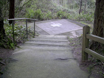 You're almost there. Ahead is a concrete platform, about ten feet on a side, a concrete (if you will) demonstration of what the Stone anchors and represents. In weathered brass are four large squares, and at the center of the interescting lines is a square containing a rough-hewn rock (which I think of at the Willamette Stone itself) and a bright steel disk with information engraved on. This is the Stone, the center of it all–or at least, the survey of an area the size of the whole of the nation of Germany.
Close up, the Willamette Stone (and the monument) look like this:
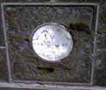
It is a little hard to see, so here's a diagram:
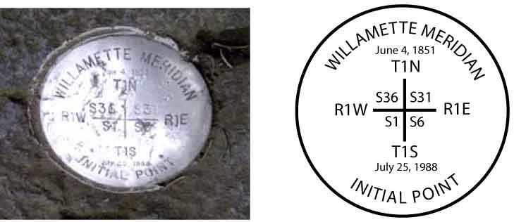 The information on the disk tells the tale of what the point means. The top date (June 4, 1851) was the date of the first survey. The plaque due south of the monument tells the tale of the monument and how it was defaced by vandals and replaced and dedicated by Vic Atiyeh (July 25, 1988).
Here's a better view of the setting:
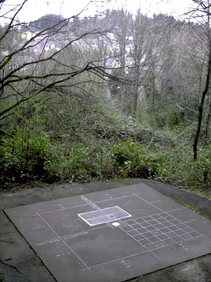
This detail allows me to point out some salient features:
- The Willamette Meridian is delineated by the centerline running from the lower right to the upper left of the picture, through the big inlaid brass plaque. This is true north-south. It is denoted with the brass inlay WILLAMETTE MERIDIAN.
- The Willamette Base Line is delineated by the centerline running athwart that; that is, almost right to left. It is denoted with the brass inlay WILLAMETTE BASE LINE.
- On the outside of the square, just visible in the resolution of the photo, are four inlaid notations: T1N (Township 1 North) and T1S (Townshop 1 South) closest to us and on the left; closest to us are R1E (Range 1 East) on the left of the centerline and R1W (Range 1 West) on the right.
- From what we know we can be certain we are looking approximately south-southwest.
- Knowing what we know about where the Multnomah-Washington county line lies, we know that the quarter of the square farthest from us (upper right in our view) is in Washington County, and we are standing in Multnomah County. The county line goes away south along the Meridian and west (to the right) alone the Base Line. Further, those houses in the distance are in Washington County.
- The grid pattern we can see is a graphical representation of the pattern of 36 standard one-mile sections each township is ideally divided into.
There are few places more remarkable and reachable in Portland.
You are here.
No comments:
Post a Comment