
 On the right, NW Miller Road, looking south at the West Stark sign; on the left, SW Miller Road, looking north at the same sign.
Continuing the grand tour of the westside's secret division from this post, so, dig, if you will, the above diptich.
This is another piece of West Stark Street, off Miller Road just north of the light at it's southern terminus at SW Barnes Road. This is the segment of West Stark that's farthest east of all; less about 2/3rds of a mile east of here, there's the Willamette Stone; just a thousand or so feet east of the light down at the bitter end of Miller, the SW Barnes Road Changes to West Burnside Road. You are on the edge of Multnomah County in more ways than one here.
The signage, apparently neglected by either adjoining jurisdiction, is handmade, presumably by a local, and affixed to the county line signs. The green color closely matches the blade colors almost universally used by either jurisidition, but the lettering is applied in a mildly amusing yellow (Go Ducks!, maybe?).
A notable fact is that this bit of West Stark is, indeed, on the Multnomah-Washington County line, dispite one laying, generally speaking, east of the other. Typically, motorists and travelers experience the county line as a north-south line, crossed going either east or west. South of the surveyed line of the Willamette Base Line (which Stark Street, both east side and west side, happen to lie on), this is a north-south line, running alone SW 65th Avenue (this is why the area around SW Borland and 65th, in Tualatin, has come to be known as "Meridian Park"; indeed, SW 65th in the Tualatin area was once known as Meridian Road).
Once the line encounters the Stone, though, it turns west, laying along the Baseline, for exactly one mile (one Range west), then one mile north (one Township), following the township and range lines for west nine miles and north nine miles. That's 18 zigzags, and gives the Multnomah/Washington county line it's unique 'look', as well as keeping Washington County on the east side of the Tualatin Mountains and the Willamette River well within Multnomah. And it's why after going a fraction of a mile west from Multnomah into Washington County one only has to turn north a fraction of a mile to get back into Multnomah again.
Now, take a look down West Stark:
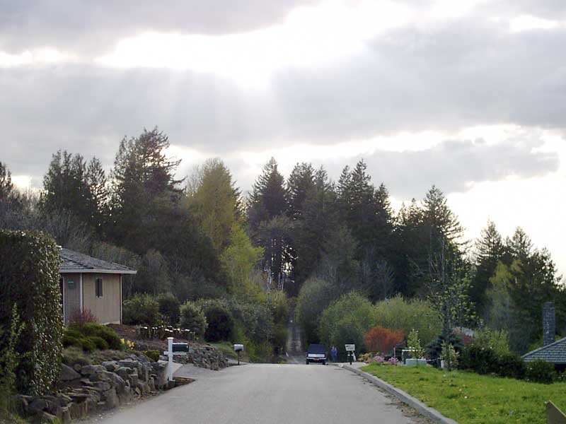 West Stark Street at approximately the 7900 block, a few steps off the intersection with Miller Road
This is a view westward down West Stark, about 50 or 60 feet off Miller Road (just out of shot on the right of the picture is a pricey Suburban McHouse). Note how off in the distance, just as the road gets to the trees, the paving gives up. Tempting to follow, but not 50 feet up that track is the undoubted End Of The Road; an old sign tells the interloper in no uncertain terms that this is a PRIVATE driveway and should you even think about using this to turn round, well, lets just not go there, and another driveway which forks off to the right and down which exults via a sign proclaiming "100 NW Tuality Way".
By my reckoning, just beyond the crest of that hill in the woods is the beginning of the part of West Stark that crosses Leahy Road/90th Avenue, just east of St. Vinnie's. The first time we visitied this section of street, what looked very much like city-street-standard streetlamps could be seen dissappearing into the grove on a straight line; "How neat", though I, myself; an uninmproved road with streetlamps. Sadly, no.
One more remarkable factor can be seen by closely examining the nature of the pavement. Noted that the right side of the street (the one in Multnomah County) has been finished with a nice curb. The left, however, in Washington County, has no such amenity. My conjecture is that the county line runs along that left pavement margin; it aligns with the location of the sign in the first picture, which one can presume was placed dead on the surveyed county line.
This is a thing that tends to happen on jurisdictional boundaries (SW Ankeny Street was planned right on the boundary of a donation land claim, and only one side lived up to thier side of the bargain of developing it, so it turned out dinky, but that's another story); it could be a jurisdictional quarrel or just differing timetables, but the other side of a line like that is off-limits. Multnomah is only tasked with improving and maintaining one side of the road; Washington the other.
Next time I post about this unique street, I'll be commenting on the part that intersects Leahy Road/90th Avenue. Stay tuned.
No comments:
Post a Comment