Showing posts with label silverton history. Show all posts

29 April 2024

You Can Almost Hear The Train Whistle

4132

On South Water, in Silverton, at the end of the park that centers on the Library, there's a building that looks quite a bit like an old railroad depot.

That's because it is an old railroad depot. When I was a lad, this building stood on North Water on the north side of the train tracks. Even when I was a kid, though, the era of passenger train service had come and gone, and the building was just used as storage by then. Some time during the 1970s, some enterprising group moved it about half a mile south on Water Street, to where it is now. 

And it's now a museum of local history, because if there's one thing Silverton knows, it's her history

The signage is preserved on the gables of the the building.


The picture depict the end of the building that points toward Silver Creek. The end of the building that fronts on Water Street will tell you that Portland is 47 miles away. Which it is, more or less, though since the building's not where it once was, some negligible error has been introduced.

The idea of a passenger train connecting Silverton to The World Outside is so damned romantic, though. This is why people think they'd be happier born in an earlier era, or at least one reason. My experience as a child in Silverton was that the place, despite its nearness to Salem, was pretty isolated. It would have felt different if we'd had rail service, though. 


06 April 2024

The Wolf Building, The Antique Heart of Silverton

4121

I've picted this building before, but it was a Creative-Commons pict. This one is copyright mine, mine, ALL MINE. 

Adolf Wolf is another one of Silverton's small gods. Silverton's city center is loaded with historic architecture and the more I think about it, the more this building must be considered one of Silverton's crown jewels that way. It has immaculate cast iron detail (which I enthused about here). It was erected in 1891 which, I think, makes it the oldest extant building in Silverton:

I remember it as a boy for Carl Hande Hardware, continuing the mercantile tradition Wolf started and marketing implements to the little farming metropolis Silverton was at the time. Of course, just like every charming old building in Oregon currently, there's a bisro there, so there's that.

The biggest charm in this image is the lovingly-preserved painted ad on the Water Street side there. 

And I might be a little sarcastic about it all, but if I wanted to open some creative concern and brand it with Silverton's charm and quirk, I'd certainly consider the second floor of that building. 

The Covered Pedestrian Bridge, Silverton

4120

In the last missive (and maybe one or two previous) I made mention of the pedestrian bridge that connects Town Square Park, next to downtown Silverton and across the creek, to Water Street at Lewis. 

Illustrated here is the bridge if you aren't on it taking pictures:


The covered bridge is something personal to Silverton; one of the most historic covered bridges in the state, the Gallonhouse Bridge, is located about two miles north of here, just outside of town (follow First Street to Hobart Road, left on Hobart to Gallonhouse Road, and right on Gallonhouse to the Bridge itself, as we will do sometime soon). So this charming little bridge, which makes it all of a piece.

The Gallonhouse Bridge was named for what people would trade at that point, during Prohibition years. The nature of the substance traded in gallons is an exercise left to the reader, but I'm sure I've left enough clues that the reader can intuit it.

The trade may have involved an ancestor; my mother liked to tell me one of the things my grandfather, the first Samuel John Klein, did, was hide 'shine on his dairy farm, which was located northeast of town about halfway between Silverton and Scotts Mills.

It's a family legend which will have to stay that way, because of reasons. But it's a fun story to hint at.

04 April 2024

Town Square Park, Silverton, and My History Thereupon

4119

As mentioned in the last posting, there is a park in the middle of Silverton now, along West Main, between the bridge and Fiske Street, which is terribly charming and comfortable, and they call it Town Square Park.

It's roughly square in shape and goes back some 100-150 feet from West Main. If one goes to the south side of it, and looks north from the ramp to the covered footbridge, just past the war memorial, the view one gets approximates the picture, thenceforth and herewith.


This is a patch of ground I have intimate history with. I'll explain.

In the middle background, in front of that brick building (which at one time was the local phone company building and probably still is telco propertry, though not in the way it was when I was young), is a length of West Main Street that runs about 160 feet in length, give or take fifteen feet or so. And along that brief bit of road, if you drove west from the bridge, there were the following three buildings on that side of the street in this order:

  1. A building that looked as though it once provided services to cars which, even in my youth, looked dusty and disused for decades
  2. Hoyt's Grocery
  3. A gas station on the corner of Fiske that started out as Hancock and later was a Fina station.
Hoyt's Grocery remains a treasured, if attenuating, memory. My mother worked there for a few months while I was a toddler and we were rooming with my Grandma Klein on South Second in the months before we moved up to, and I commenced my formative years on, Steelhammer Road. And many times during that childhood we stopped in for this and than at Hoyt's.

It was the old-school kind of small market, unlike today's quick-shops, c-stores, and roadside markets: it was stocked with dry goods, a small selection of produce and meat, and essentials that you could stop for on the way home if you didn't feel like going over to Roth's or the Safeway. I mean, we knew the owners. They were sweet people. I remember old Lillian Hoyt, how she was just this sweet old lady who ran the grocery store with the assistance of her family, how she lived in the apartment in the small triplex that was tucked in behind that gas station on the corner. I remember how the sign over the front of the store had HOYT'S GROCERY in big, chunky, curvily voluptuous letters, the way that sign was bracketed by two big 7UP (I think it was 7UP, anyway) signs, and the way the front wall was actually set on a track and could be opened like a closet door if they had to. I remember the wooden floor of the place.

And now here am I, wandering through this park and there's no trace of those places. I hope pictures of the old grocery store exist somewhere. I'd like to see them again. 

And now here am I, wandering through this park and in spaces that I couldn't have walked to when I was small, and thinking about how we think as we grow aged the world moves on without us and we can think that way if we want, but we can also think that things change and the world does move on but it moves on with us as passengers and the views from the ride are actually quite lovely, if we accept what we see. 

Getting too philosophical means I've maundered a bit too prolix, and I should leave this here. 

And that I shall. 

24 March 2024

Silverton's Small God

4104

This was seen on the property of the Silverton Coffee Company, on South Water at Lewis:

And this, on the doorstep of the Palace Theatre, which I have just rhapsodized about:


Know ye of Bobbie the Wonder Dog? 

In August of 1923, a Silverton family visited Indiana with their Scotch Collie/English Shepherd mix in tow. During that visit, the dog, as the legend has it, was attacked by other dogs and ran off. The family, not able to locate their pooch by the time they had to return, did so, undoubtedly with hearts heavy with the knowledge that they'd never see their dog again.

Except he turned up again in Silverton n February of 1924, showing every sign of having physically endured a trek of at least 2,500 miles just to get back home to Oregon.

I've always said Oregon has this pull on natives. But then, if I found myself in Indiana, the first thing I'd probably do is try to leave, so there's me for you.

Well, in the way that things went viral in the 1920s this did, and not only was Bobbie a local hero but became a national celebrity for a short time, and in doing so cemented his fuzzy visage indelibly into local history.

And, as one can see, not only is he celebrated in one of Silvertons many murals, but also in at least two figurines, one about two blocks away from the other in Downtown, and making himself an excellent candidate for the patron spirit of the area: Silverton's own charming and relatable small god.

Silverton: dog is their co-pilot.

The Palace Theatre, Silverton, At Dusk

4103

The gem of town shines out as it once did, brilliantly at dusk, at Oak and Water Streets in downtown Silverton, Oregon, the kind of theater that's still the kind of place were you can walk in and imagine kids streaming in to get imagination fuel, for adults to come for entertainment. 

This is the Palace Theatre, Silverton, Oregon, year 2024.

There has been some sort of entertainment venue on this corner for more than 100 years. Before the Palace, it was the Opera House, which was destroyed by fire in 1936. 

The past few years for this old cinematic matron have been, if the news reports I've seen are an indication, a bit rocky. In 2012, fire seriously damaged the lobby. The venue got back on its feet, then the owners, one of them the inimitable Stu Rasmussen, had to give the business up. The succeeding owners were not able to keep the place alive and she closed again, and then the current owners came in and really pulled out the stops to get the place back into the swim.

The Palace re-opened for good this last winter with a run of the Timothee Chalamet Wonka film and has returned to stay.

The facade is a warm and cherished memory and, paint scheme tastefully highlighting its Art Deco design notwithstanding looks quite like it did when I was a lad, including the marquee ... although they do get bonus points from YT for that splendid sign centered in that facade. 

We much approve.

23 March 2024

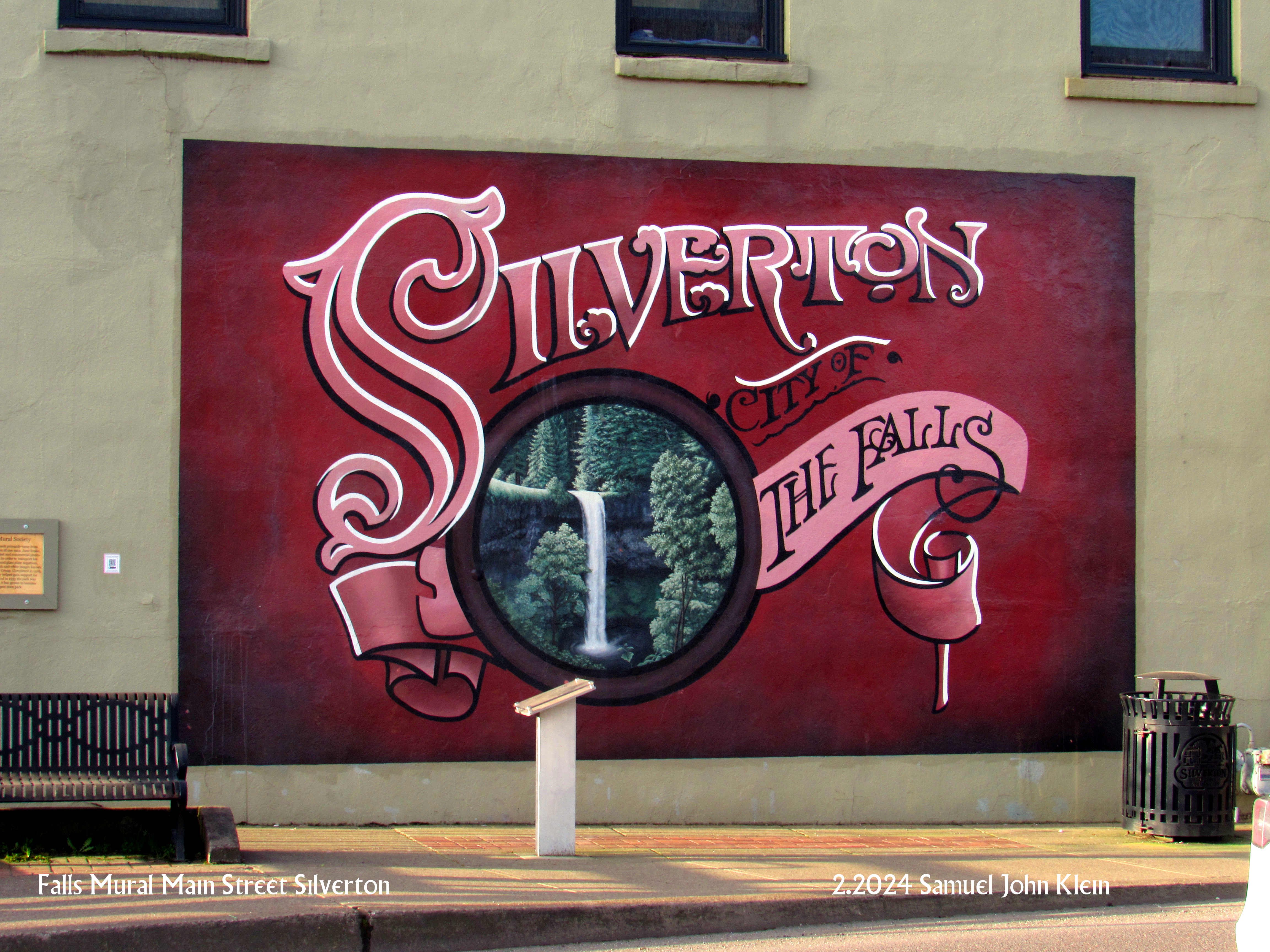
Falls Mural On Main St, Silverton

4102

Another Silverton mural, of which I'll have a few in the next several articles, which is found on the north side of East Main Street between the end of the bridge over Silver Creek and the intersection with Water Street:

Silver Falls State Park is the gem of the state parks system, the crown jewel, the largest single state park ... it's to Oregon State Parks what Yellowstone is to the National Park system as far as a star player goes, and if you're in Silverton, it's not just in your back yard, it is your back yard.

If it weren't for photographer June Drake getting the ball rolling back in 1902, it might never have been, but then ... Silverton was always a town for photographers.


20 January 2024

Details of Silverton's Wolf Building Are Cast In Iron

4099

At the corner of East Main and North Water in downtown Silverton stands the Wolf Building. It was built in 1891, making it 133 years old at the time I'm writing these words. 

There's a district of Portland that this reminds me of, and it's the Skidmore/Old Town district. Decades before Portland began to grow into a Real Big Town, that area had architecture accented with wrought iron that was of exquisite detail; few examples still remain. The most prominent example is the New Market Theatre building. 

The Wolf Bulding looks this way:

The Wolf Building, 201-205 East Main St, Silverton Oregon.
Photo by Ian Poellet. Source.

The photo was taken by another photographer; I am surprised that I do not have one of the facade ... yet.

Adolf Wolf commissioned the building and set up a hardware and dry-goods concern. During my lifetime, it was the friendly, wooden-floored hardware store of one Carl Hande. Concordant with the general upscaling of Silverton over the years, it is now a stylish bistro. The upper floor currently has office space, if I understand correctly. 

Just as with many things of this nature, the eye is rewarded by closer inspection: at the bottom of those sunny yellow verticals in the facade are these fittings:


... all the way from St Louis, yet. Fancy.

The loving care with the facade continues over the sidewalk, too:


One thing about the local Kiwanis chapter; I think it's always met there.

That can be something out of Silverton Gothic: The Kiwanis Club meets Thursdays at 7:00 AM at the Wmlf Building. It has always met there.  

24 August 2020

Silverton, Oregon, Within Her Borders Of 1922

3746

Today has been productive when it comes to serendipitously finding things I've been looking for. There are so many things on the 'web, and so many ways to find them, that sometimes it takes years to put just the right terms together. So it is thus.

On thing I've always been curious about is the annexation history of Silverton, my birthplace. Silverton's geography and street layout have always been one of the most intriguing things to me, and one of my insatiable curiosities has been 'why', or if not that, at least, 'how'. Under the aegis of the esteemable Gus Frederick, I have acquired the knowledge of Silverton history that I always should have had but nobody bothered to ever present to me. He also connected me with McEachern's Silverton: The Morphology Of An Oregon Town which answered a great deal of questions about how My Little Town grew, and if it didn't give me any clues of the town's annexation history, I did get a certain idea of what Silverton's boundary looked like at incorporation confirmed, to a degree.

I'm considering a little thought experiment that'll require a map of Silverton to play on. I know where to go at the ODOT website to get one, but I did a bit of Googling just to see what I could find. And boy, did I stumble on something pleasantly unexpected. It would seem that the Library Of Congress would have something that would enlighten, namely, 17 scans of the 1922 Sanborn Fire Insurance map of Silverton.

What I include hence is the sheet showing the entire town. This is a city map containing all the streets in town at the time, and the city limits as of 1922. They are identical to the city limits at incorporation McEachern detailed in one of his excellent diagrams. 

When I was a kid in Silverton and got familiar with the map, I did find that I enjoyed the shape that the city limits in that time enclosed: a big ol' wing sweeping back from the north side of town; a leg reaching down Silver Creek ending at Ike Mooney Road; but what really intrigued was the visual suggestion that all these additions attached to an original town that was shaped rather as a square. McEachern's diagram confirmed that but gave the footprint a small tail on the southeastern corner of that square, as does this Sanborn map.

Something that really jumped out was the geographical dominance of Silverton's two lumber mills. Before I was alive Silverton was a big timber town, and in the north part of town the yellow area marked 17 and the blue area marked 13 were all lumber mill. As Homsar might say, I'm not gonna lie to ya, that's a healthy piece of real estate.

I note also that most of the streets in Silverton have always been called what they were called when I was a kid and what they're called today. There are very notable exceptions, perforce, in no particular order:

  1. What we call today East Main St going east from the center of town ("Danger Hill") was noted as Broadway.
  2. Maple Street, which is a short street connecting the ends of Grand and Sherman Streets just south of North Water and just north of a meander in Silver Creek, was called N. Front St. 
  3. The section of B Street east of Mill Street and West of Hill Street was then called Madison Alley, which is a whole lot cooler of a name than "B Street" but then, they didn't hire me to figure out street names for 'em
  4. On the western edge of town there's a street called Lower. Today's Silverton has that as Westfield Street. 
  5. In the north, in the area today called "Milltown" the north-south streets are labelled with what must be the names the original developers gave it: 1st, 2nd, 3rd. Today those streets are known, respectively as North 2nd, Elm, and Fir Streets. 
  6. In the northeast part of town, between Church Street and Norway Avenue and north of Chadwick Street there's a connecting street called Plamateer Avenue. Today that's known as Bartlett Street; the short T street capping that at the east end of Bartlett, on our Sanborn map known as Wolford, is today known as Wall Street. And, north of that, a short street comes off the north end of Norway and is called Solum; today's more prosaic name is Liberty Street. One can't help but wonder about the reasons behind those changes.
  7. The east side of town has also seen intriguing changes. The street known as Rook Street is, comparing modern maps, Rock Street; what was then marked as W. Park Street is now called Ames Street; the next street to the west is not marked nor does it exist on the ground however E. Park Street does (it didn't when I lived off Steelhammer Road, back in the day). 
  8. And, speaking of Steelhammer Road; it's that street that is marked as simply East. Practically named, anyway.
  9. There is now, as there was then, a W. Center Street, coming off West Main about halfway up West Hill. What is now S. Center Street (coming off W. Main going south from that intersection) was known then as E. Center St, presumably to differentiate it from that street coming off S. Water known then as S. Center St and today called Central Street. 
  10. And, last but not least (for now), what we today call Cowing Street was known then as S. Mill St, to draw the difference between it and the Mill Street serving the two lumber mills on the north side of town. This mill street was named for an altogether different mill, the old Fisher Flouring Mill, which was along Silver Creek just north of there. 
  11. Also, in the south part of town, between South Water and Silver Creek and running parallel to both there is a street that is modernly called Madison Street. In the Silverton of 1922 it was called W. Water Street.

Those, to me, are some fiercely interesting changes, just as interesting as the 1922 city boundary, and the seal in the upper right hand corner which duly reports that in 1922, Silverton's population was 2,251, and the prevailing wind was from the southwest.

The entire run of the 17 sheets can be found at the Library of Congress at https://www.loc.gov/maps/?all=true&fa=segmentof:g4294sm.g4294sm_g074631922/&sb=shelf-id&st=gallery