
2000.There are thirty-six counties in Oregon and just about thirty-six ways of looking at things. What if we took the names of those POVs and mixed them up just a bit?
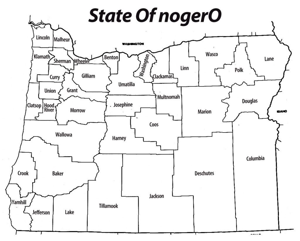
This map is a map of Oregon's thirty-six counties but the names have been changed to provide food for thought. In a spreadsheet, I ordered the counties largest-to-smallest population, then created another list from smallest-to-largest. Pairing the lists and remapping the names, I then went down the combined list, labeling the county with the smallest population (Wheeler) with the name of the county with the biggest population (Multnomah). Here's what I got:

Clicky here to embiggen (Some of the names come out pretty small).
I found the way the names broke to be interesting both in the expected and the unexpected way. As I expected, a lot of wetside counties fled east and a lot of dryside counties fled west. Notice that the three biggest Oregon counties – the legendary Portland Metro area – still touch, but to get to Washington (schematically anyhow), you'd have to travel through Clackamas. Polk (now sitting in Union County's place) now separates Marion (whose seat is the state capital, Salem) from Lane (seat: Eugene), and I'm sure the idea of the U of O somewhere in the Wallowas sets more than one extreme sports-oriented college student alight.
Ironically, the three counties of the Portland Metro Area still abut the Columbia River, but along Clackamas and Washington – which is exactly the opposite from reality.
As interesting as the counties that changed region is the ones that didn't so much, like Jackson-which simply shifted eastward across the lower tier-and Harney and Deschutes counties have simply switched places. Counties containing regional centers-such as Josephine (seat: Grants Pass) and Jefferson (seat: Madras) mapped to each other.
If nothing else, it seems to show a clearer division between small-town Oregon (places like Fossil, K-Falls, and Prineville) Mid-size town Oregon (Bend, Pendleton) and Big-city Oregon (Portland, Salem, Eugene).
And, finally, really if nothing else, the mental luggage that each name carries mapped to an unexpected place really causes you (well, me anyway) to look at assumptions we tend to carry about regional stereotypes and character. With Oregon covering nearly 100,000 square miles, this is info recoding writ large.
And it was a fun little mental game too.
Technorati Tags: Oregon, Map Design, Information Design, Samuel John Klein, nogerO, Information Recoding
This map is a map of Oregon's thirty-six counties but the names have been changed to provide food for thought. In a spreadsheet, I ordered the counties largest-to-smallest population, then created another list from smallest-to-largest. Pairing the lists and remapping the names, I then went down the combined list, labeling the county with the smallest population (Wheeler) with the name of the county with the biggest population (Multnomah). Here's what I got:
Clicky here to embiggen (Some of the names come out pretty small).
I found the way the names broke to be interesting both in the expected and the unexpected way. As I expected, a lot of wetside counties fled east and a lot of dryside counties fled west. Notice that the three biggest Oregon counties – the legendary Portland Metro area – still touch, but to get to Washington (schematically anyhow), you'd have to travel through Clackamas. Polk (now sitting in Union County's place) now separates Marion (whose seat is the state capital, Salem) from Lane (seat: Eugene), and I'm sure the idea of the U of O somewhere in the Wallowas sets more than one extreme sports-oriented college student alight.
Ironically, the three counties of the Portland Metro Area still abut the Columbia River, but along Clackamas and Washington – which is exactly the opposite from reality.
As interesting as the counties that changed region is the ones that didn't so much, like Jackson-which simply shifted eastward across the lower tier-and Harney and Deschutes counties have simply switched places. Counties containing regional centers-such as Josephine (seat: Grants Pass) and Jefferson (seat: Madras) mapped to each other.
If nothing else, it seems to show a clearer division between small-town Oregon (places like Fossil, K-Falls, and Prineville) Mid-size town Oregon (Bend, Pendleton) and Big-city Oregon (Portland, Salem, Eugene).
And, finally, really if nothing else, the mental luggage that each name carries mapped to an unexpected place really causes you (well, me anyway) to look at assumptions we tend to carry about regional stereotypes and character. With Oregon covering nearly 100,000 square miles, this is info recoding writ large.
And it was a fun little mental game too.
Technorati Tags: Oregon, Map Design, Information Design, Samuel John Klein, nogerO, Information Recoding
4 comments:
30K people in our "metro" area and you stick us in with Fossil? Ouch.
Well, actually, you switched with Tillamook, which is a fine, fine county and city. Very lovely place, as I've found.
Great cheese, too. Love visiting that cheese factory.
B-)
I meant in your descriptions of small-town, medium-town and big town.
No longer a fan of Tillamook after what retardedness they tried to pull on the residents of Bandon after they bought Bandon's cheese factory. Bandon cheese had Tillamook beat hands down, as well, for general tastiness. I don't mind if other people enjoy Tillamook, but I just can't.
Oh, I got you there. Mea culpa. Altho I find that Fossil has a pretty good reputation as a nifty place. You could be in worse company, trust me.
As far as Tillamook goes, yes, that was pretty stinky the way they started throwing legal weight around Bandon a few years back and didn't stop until it was bad PR. Better that they didn't do at a'tall.
Someone around work says "It's nice to be important, but it's important to be nice."
It's a corny thought, but I think she had a point there.
Post a Comment