Showing posts with label Sandy Blvd. Show all posts

27 June 2021

Olivia the VW, June 2021

3955

This is the year this girl turns 50. 

I drive a 50 year old car. The styling, though, is timeless. 

I call this Olivia on Sandy Boulevard (Parkrose Interlude 2021). 

She's washed, lubed, the oil's been changed (just in time, I'd say) and the valves have been adjusted. It's hard to fine good VW mechanics and ours is damned good ... and a bit off-the-beam. But classic VW mechanics are like mad scientists, in the good way. 

When it finally cools the hell down, I've the idea to road trip with her down through Silverton because that's where I learned to love VWs. Many pixs should ensue from that ... but that's anon. 

Anonish.

Parkrose: NE 108th Ave, In Living Color

3954

If they hadn't been setting up for today's Parkrose Marketplace, I never would have glanced. And I've driven by this bit of road for years now. 

About 100 feet or so of NE 108th Avenue immediately off Sandy Blvd ... between the former furniture store withe the guy in the black hat on the sign and the former dive bar ... has these most delightful large dots of color painted on it. And as it happens they're having a neighborhood market today. Of course, the heat being what it is, if you ain't started by now I'd not go, but if you're in Portland and of the mind to do so, might be fun to check out.

Today they started early, at 9 AM, to beat the heat, but it was almost in the 80s by the time I went by around 7:30 AM, so I don't know how successful that move was. I do wish them well, and think maybe we'll go and experience some local color when it isn't so damnably hot.

25 May 2021

The Portland Immigrant at Sandy and Killingsworth

3899

It's kind of an inauspicious place to be honored.You can't really pull over to admire this monument.

At the west end of Parkrose's business district, that busy place where NE Killingsworth (or NE Lombard, this time next year) terminates at Sandy Blvd, and where NE Sandy Blvd ceases its diagonal climb out of the Portland's core to align with the historic route of the Columbia River Highway, where traffic to and from I-205 throngs day and night, and where the only neighbors are two hotels and a cemetery, there's a traffic island where the flow parts to go every which way, and there is a landscaped terrace on this island which functions as a plinth of sorts, and on it, a weary-looking fellow casts a tired gaze on the Best Western Pony Soldier Inn.

The Portland Immigrant gazes at the Pony Soldier Inn,
Sandy Blvd dwindling into the background

The Portland Immigrant means to remind of all of us the vitality and spark that those who come from other countries and parts of the world bring to the blend of people and dreams that try to coalesce to form Portland, and that they may come here as weary travellers but with energetic dreams they too want to make real.

The surroundings, as I said, don't lend ones' self the opportunity to pull over and look. Where Sandy Blvd cruises through Parkrose also happens to be the place, once, where most people who came to Portland entered town; at one time, this was Portland's northeast corner, and US 30 the main road into town. There's no real place to pull over to enjoy this spot so, in a certain sort of cosmic sarcasm, motorists tend to race past, not really paying the monument much mind, unconsciously mirroring some of American society's poorer attitudes about the role immigrants play.  

Still he remains, just waiting for you to see him and what he means. It's your move, my friend. 

08 April 2021

Sandy Blvd As Seen From Council Crest, May 2010

3814

Today's throwback gem returns us to our Council Crest crow's nest of the year 2010 to look at one of Portland's most unique eastside features: Sandy Boulevard. that magnificent diagonal road.

In its entirety it runs from SE 7th and Washington all the way out to Troutdale, the road actually carrying a SE directional from its root to where it crosses Burnside at 12th. As we all may be aware, this was an unbroken road until the Burnside-Couch one-way couplet was decreed, which closed off that first two blocks of NE Sandy, 12th to 14th, and now there's big condo silos there so there will be no going back on this, no, not ever. And, east of 99th in the Parkrose nabe it stops being that magnificent diagonal boulevard and more or less follows the line of the river about a mile north.

The diagonal part, though, is a defining Portland thing for me. No town does diagonal roads quite like Portland does.


The road, ironically, isn't absolutely straight, although it seems that way on maps. The very mild kink in it is easy to miss unless you're looking hard at it. It's obvious on the ground, but not so much from above. And that kink is actually easily observed as in the photo, when you have an acute-angle perspective on it. That bend is where you'll find the Portland nabe known as Hollywood, kind of a downtown for middle-northeast Portland.

Immediately to the right of that, the only high-rise visible in that area, is an apartment complex called Hollywood East; public housing, a 17-story tower at 44th and NE Broadway. And I doubt that it would be obvious even today from this vantage, but a lot of the buildings in Hollywood have been swapped out for other buildings, especially along the north side of Sandy between about 42nd and 47th. 

Beyond that a pale blue streak across the photo denotes the Columbia River, and beyond that? Oh, some part of eastern Vancouver, or Camas perhaps. It's all pretty much the same in that part of Clark County Washington.

18 August 2020

Block Numbers: There's Something About NE Fremont and Sandy

3737

Let's go back into street blade and Address Nerd territory with gun and camera.

Well, with camera anyway.

Allow me to introduce you to the intersection of NE Fremont St, NE Sandy Blvd, and NE 72nd Avenue,  in the Roseway neighborhood. This is pretty much downtown Roseway, really: there's Fairley's Pharmacy, the Safeway store, a handful of small shops, a liquor store, a theater, a handful of Vietamese-owned businesses. The late Yen Ha restaurant and lounge is here.

Now, keep your eyes on the road, and don't tell the officer you didn't see the sign.

NE Sandy/72nd/Fremont, looking east on Fremont
from the west side of the intersection

In NE Portland, at the point where diagonal Sandy Boulevard crosses straight east-west NE Fremont St, NE 72nd Avenue also happens to cross. In the big photo above, you can see it entering the plenum from the right, which is south, just behind the mansard roof of Annie's Donuts and just before the US Bank. Off to the left, well out of shot, the street continues northward from this intersection as a sort of parkway  with a very wide boulevard median, similar to the segment of SE 72nd running from Holgate Boulevard to Foster Road. This parkway goes from approximately Fremont/Sandy to NE Prescott Street, about half a mile.

Now, I've prattled at length somehwere at least once or twice in the past three-thousand, seven-hundred plus visits to this blog about how to read a Portland street blade. And when you put a block number on a street blade as an aide in motorist navigation, there are essentially two ways to do it:

  1. The block number on the blade indicates the block of the street named on that blade, based on where the intersecting street cuts across. In other words, if I'm in Salem, and I'm on 12th St SE, and I look at a sign saying 12th ST SE and the block number says 3000, then what that street sign is telling me that it's directly labeling that block of the street that I'm on. This seems to be the most common way of going about it. Or:
  2. The block number on the blade indicates the block of the street you're on as defined by the intersecting street, which in Portland will be whatever block you're either entering or leaving as you go. Say I'm on SE 52nd Avenue and I come to a stop at SE Woodstock Blvd. The block number on the Woodstock blade will read 6000. This does not mean that's the 6000 block of Woodstock; it means Woodstock defines the beginning of the 6000 block of whatever street's crossing it. I'm either entering the 6000 block if I'm heading south  or leaving it for the 5900 block if I'm heading north.

Number 2 is Portland's way of going about it. From what I've been able to see, though Portland is hardly the only city that does it this way (Salt Lake City has perhaps the most extreme idea of this sort of thing). It also lets you know how many streets away from, and quickly estimate your distance from said baseline (Woodstock at 6000 is the sixtieth block south of Burnside, and is therefore three miles from it). 

It also influences geographic parlance: in Portland it's common to hear it put as "Woodstock is the 6000 block" or "Hawthorne is the 1500 block". It's particularly useful in a town like Portland where the grid is so strong through most of town. It's also why you don't see block numbers on the numbered avenue signs; since the hundred block of numbered avenues in town is keyed to the avenue number, it follows directly from the street name (NE 15th Avenue is the 1500 block of named streets that cross it).

There's more I could say but all that I've laid down so far should have set the table for what I'm about to lay on you. Pay attention:

At this intersection, you have two major traffic streets, NE Sandy Boulevard and NE Fremont Street, and a local side street, NE 72nd Avenue. Sandy runs at a diagonal, so it has no standard block number; it depends on the rise/run at the point of intersection. Now that does happen to be Fremont. What's Fremont's block? It's the 35th block north of Burnside; Fremont Street is the 3500 block, at least of NE 72nd Avenue (Sandy Blvd is numbered as an east-west street, so it's building numbers at that point would be the same as Fremont's which would be 7100 7200.

Okay, knowing all this, what would you assume would be the block numbers on the named blades for NE Sandy Blvd and NE Fremont St? Since Fremont is the 3500 block north, and Sandy cuts 72nd at the 3500 block, you may have guessed that the block number on those street blades would read 3500.

That's an entirely reasonable assumption. It's also incorrect: Here is what they do say:


That's right. Not 3500, but 7200. That's the block that 72nd intersects both those streets at.

It's like that on all points of the intersection. I've walked the entire thing more than once and I did on that day. The following picture is the extreme northeastern corner of the intersection, where the northbound side of NE 72nd north of Sandy leaves Sandy Blvd:

The block number on the Sandy Blvd blade?:

Yep. 7200. As is the one on the blade of Fremont Street pointing east from NE 72nd Avenue.

I've done a lot of reasoning about this because it is rather bewlidering. The Portland system of street sign information is actually fairly simple but just like every system it will run into cases where the demands of reality test it to a limit and this would appear to be one of those situations. It fails in a way at delivering the information one expects. But my going over my multi-decade store of impressions and expectations as to the information this system can deliver, I can at least, I think, provide an insight, that will cause it to at least make sense.

Bear in mind that I can't read PDOT's collective mind and that I do not function as any sort of consultant on these matters to them (I mean, I should, that would be just and righteous, but I don't. C'est la guerre, mon frere).

In referring to Portland street blades over my adult life one decoding principle I've used in interpreting this information is that the intersecting street blade tells you all you need to know about where you are on the street you're travelling on. You, presumably, don't need to be reminded of the name of the that street you're travelling on; you intentionally put yourself there. Here am I, say, going northbound on NE 60th Avenue crossing Glisan. I look at the sign and I see NE GLISAN ST 500, and I say to myself Well, I know I'm going into the 500 block on NE 60th and I just crossed Glisan St. 

That street blade told me information relating to the street I was most likely to be on. Since 60th and Glisan only is composed of two intersecting streets, that further possibility is like an algebra term that multiplies by zero and falls out. I'm only going to be on one street or the other.

But what if the intersection I was at had three streets intersecting and only two of them were major through traffic routes? With the limited amount of room on the sign, what would I do?

What if, proceeding from the example of 60th and Glisan, I prioritized the needs of travellers coming into or through the area rather than those who wanted a reassurance that Fremont is the 3500 block north of a relatively-much-lesser travelled intra-neighborhood street? If that were true, then maybe I'd want to put 7200 on all those named street blades:

  • If you're on Sandy Blvd, the intersection of NE Fremont Street defines the 7200 block of NE Sandy.
  • If you're on NE Fremont Street, the intersection of NE Sandy Blvd defines the 7200 block of Fremont
  • NE 72nd Avenue, being a comparatively little-used street, and less likely to be travelled on by people who are through-bound on Sandy and Fremont, can be left off the signs and cause minimal confusion and inconvenience because most locals already know that the 3500 block starts there and those through-bound people are more likely to be concerned with what block of Sandy or Fremont they're at.

So, there it is. I'm not saying I approve or disapprove, what I am saying here is that this is what I think the method behind this madness is. And there are other places in Portland where block number blade mistakes exist, and even some intersection signs which appear to contradict this logic within blocks of this very sign too ... Sometimes I don't know where PBOTs mind is on some of this.

And ... I still like the Portland system better than any others. But it does have its weaknesses where confusion can occur. This'd be one. But then, why even be in a city if you aren't going to take your time when you can, and look carefully around at your world.

12 August 2020

Rose City Park Storefronts

3730

No agenda with this one. Just a line of storefronts on NE Fremont Street just as it arrives at its plenary corner with NE 72nd Avenue and NE Sandy Blvd. 

Kinda bland, kinda ordinary, nothing special ... but everything special because of it, somehow.

The neighborhood around this intersection is called Rose City Park. It was laid out in 1907, the inaugural year of the Portland Rose Festival, for what that's worth.

NE 82nd And Sandy: The End is Nye

3729

I'm not sure if this is some sort of inscrutable prophecy or just an apt play on words, but I love it.

Taken through the front window of Olivia at the corner of NE 82nd and Sandy in front of the used tire store there. I've seen this in a number of locations in NE Portland.

Little visual treats like this? Yeah, it's one of the reasons I still love Portland.

10 August 2020

The Giant Jug On Sandy Blvd

3728

There's a dive bar of incredibly long staning along Sandy in Northeast Portland. 

On the north side of Sandy, on another one of those flatiron blocks, this one also bounded on the west by NE 74th Avenue and the north by NE Beech Street, is a building with a long history. Lore I've heard recounts it as having been built in 1928 originally as a tire and auto repair joint. I don't know when it became a dive bar, but that it did for years and years and years. 

It's one of those buildings which became a landmark and probably still exists because it is one. 

I give you The Pirate's Cove:

The Pirate's Cove is a dive bar, and one of Portland's many strip joints; it has been named suchly since 2002, and eighteen years is an eternity in Portland cuisine these days. Before that, though, it was an outfit called ... are you sitting down? ... 

The Sandy Jug.

This terra cotta drabness is just one of many dressing changes for the building; at one time, the spherical cork in the jug was painted like an eight-ball.

That's it: just another Portland dive-bar strip-club ... of which there were a dwindling number going into the pandemic time.

The Smallest Triangular Restaurant We Know, and the Street Sign at Mason and Sandy

3727

Sandy Boulevard is one of Portland's signature arterials. Starting from the corner of SE 7th and Washington, it does a curl up that hill then shifts from SE to NE at Burnside (and is now made discontinuous by the Burnside-Couch couplet). It then strikes out diagonally across east-side Portland, creating complex intersections and small flatiron-shaped blocks in its relentless drive to Parkrose, many of those blocks containing almost absurdly-small flatiron-shaped buildings.

One of those is on the block bounded by Sandy, NE 81st Avenue, and NE Mason Street. This is directly to the west of the major intersection of NE 82nd and Sandy. This block is scarcely 100 feet long on the hypotenuse, and it is absolutely full of a very charming little breakfast and lunch place: the Cameo. It's directly across Mason Street from the Cameo Motel to which, we surmise, it was once organizationally-attached to as the motel's cafe. There seems no such affiliation now, but it's retained its old sign and name as it's become rather a landmark.

This is it, looking west from where Mason splits from Sandy:

We were there a few times before the Covid hammer came down, and found it most delightful. It's the kind of place, you know the kind, where the breakfasts and omelettes come at a price but you get what you pay for, satisfying and filling or, at least, you'll be taking some home to eat later.

The Korean ownership inflected the menu as one might expect. Kimchi is available in a few dishes, and there was even an omelette having that as its principal ingredient. One of the the times we were there they had a live guitar player in for the brunch crowd. Everything was very nice there.

The practice of Portland's street blades identifying the address block of the street one's travelling on by telling one how the intersecting street defines it has created, over time, spots on Sandy Blvd that tend to be bewildering, hampered by an inconsistent approach on the part of PBOT's signing. I have a few examples that will follow this. But here is a good introduction to this issue.

Please direct your attention to the street blade set there.

NE Mason Street is the 4100 block north of Burnside, so you see the 4100 there on the corner of its blade. The 4100 doesn't apply to Sandy, though: it's a diagonal road which addresses as an east-west street. The 4100 does, however, apply to NE 82nd Avenue, which runs perpendicularly to Mason and is about thirty feet behind me as I was standing to take that picture.

The 8200 on the Sandy blade might just be straight-up weird to anyone who comes from a town where the block number refers to the block face rather than the intersecting street. Look at it this way, though: You're on Mason Street, coming east out of that neighborhood. You come to the stop sign. This street opens into the intersection of 82nd and Sandy but this corner is just short of a solid intersection with 82nd. Sandy isn't the 8200 block east of the river and Williams, but it does cut across Mason at the 8200 block, or at least close enough that it would apply. 

Now, you could argue that the block number on the Mason blade should also read 8200 by this logic, since Sandy cuts Mason at the same place, but as potentially confusing as that might be for the out-of-towner, it does provide the North-South block for those passing by on 82nd (for which the position of this sign might make it a little hard to see, but the logic does work out).

Actually, I love this system despite its pitfalls. Once I got tuned into it, I find it makes a solid bit of sense: it tells me what I need to know about the cross street. I already know the name of the street I'm already on. 

But explaining it makes for some prolix profundity, that's for sure.

28 June 2020

The Rainbow Tacqueria Of Parkrose

3705NE Sandy Boulevard east of 99th Avenue is a wholly different Sandy Boulevard. This neck of the woods is downtown Parkrose, a neigborhood of outer east Portland that has, along its commercial axis, seen better days, as many areas are in this time of flux.

Sandy Boulevard - a road named not for the little town way out toward Mount Hood but because it stretched toward the Sandy River, according to MacArthur - stops being a diagonal road at this point and follows the general trend of the Columbia River about a mile to the north. This road, once US Hwy 30, used to be one of the principal east-side gateways to Portland, and architectural legacies of that time can still be seen along that mile-or-so of road ... buildings with vague Art Deco lines, which served interstate travellers at one time with nightly lodgings are now shabby-yet-clean motels and small businesses. It's history through a smudged glass.

At the corner of Sandy and NE 115th, there's a building that echoes that Art Deco detail. Sitting at the corner of a lot containing an L-shaped building that appears to be apartments now but at one time must have been a roadside motel is the Antojitos Mexicanos Taqueria.

Up until a few months ago it was content to wear a coat of bland, oatmeal-hued paint. Nothing special. Then, one day, it exploded in color. Now it looks like this:

From the west:


And, from the east:

Simple yet playful, and anything but boring, thanks to an artist named Pablo, who signed the work in the lower right corner of the facade, with a date of 2020.

It, like many eateries still, is closed, only takeout at this point.

21 June 2020

The Ziggurats From Four Miles Out: NE 57th And Sandy

3698Portland is a city which, to the Oregon mind, sprawls, but is still personal-sized. Herewith another example.

Portland's got an angle. It's not an insider's angle though, and it's easily findable by anyone on any map; it's called Sandy Boulevard. Starting at SE 7th and Washington and through the Parkrose district, where it more aligns with the Columbia River, Sandy Boulevard is a great diagonal. Rising from the east side center of town to what was once merely the northeast corner at about 30 degrees, it cuts through all walks of Portland life; from the affluent to the merely prosperous, it connects all.

It's more than five miles worth of fork intersections and small flat-iron shaped buildings, has one television studio, it's main-street Hollywood District, its a small clutch of Asian restaurants up near 72nd, the Pirate's Cove with the huge jug-shaped building, it's the good, the bad, the ugly, it's as iconic as any Portland arterial.

Portland's Wilshire Blvd, really, in a way.

It also surmounts the comparatively flat eastside's actually-rather-undulating geography. As one moves east from the Hollywood District's business center, you go up a very long climb, which levels out at NE 57th Avenue. Here, at the crest of the Alameda ridge, you look back the way you came, and you have an extraordinarily interesting POV on Portland's City Center. Thus:


This is just about four miles away from that red rocketship-shaped building. Iconic Portland landmarks you can see from here is that rocketship (the KOIN Center), and the stalwart Wells Fargo Tower on the right. Visible in front of the KOIN Center is the new Multnomah County Courthouse. Just to the right of that, recognizable by its tilted chapeau, is the Edith Green/Wendell Wyatt Federal Building. Right and alongside that is the bland striped buffness of One Main Place. That's the south side of downtown.

To my right here, out of shot, is a lawn and within that lawn is a plinth in front of the German-American Society, and at one time upon that plinth was a statue of George Washington, but then the protests came and began serious iconoclasm. The statue, pulled down, has been pulled off the field of play. We wish it well.

15 December 2017

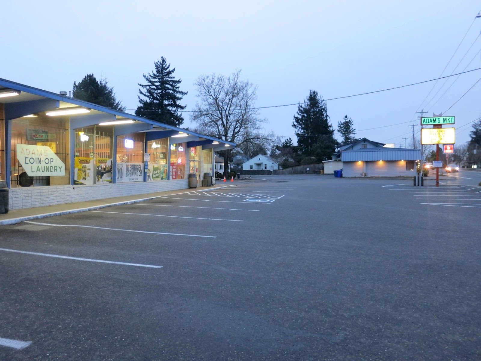
Old Parkrose: Adam's Market, NE 111th and Sandy

3544.
One more thing to share today. Adjacent to the lot that contained the Carolina Motel is a lot that holds a little commercial strip building. In any other part of Portland this might hold some artisanal boutique or something. Here, it's much more Old Portland, and much more prosiac.


There's a corner quick-shop, a coin-op laundry (which has pinball, vintage video games and wood paneling straight outta the 1970s) and a little beauty parlor (just out of shot on the left).

It's forlorn in the morning light, kind of shabby but absolutely clean and trim and tidy. Not a spot of trash in the lot. And Adam's Market, open and ready for business. It's the quiet time at 111th and Sandy, though; not a customer in the place.

But this sign? I love this sign.


Adding FISHING BAIT to the mix on the sign? That elevates its game from Old Portland AF to Oregon AF.

Lost Portland: The Carolina Motel, Parkrose, Sandy Blvd

3543.
Today I stopped by the corner of NE 112th and Sandy Blvd in Parkrose.

For those who don't know, Parkrose is a neighborhood of northeast Portland, centered more or less on NE 102nd Avenue and Sandy Blvd. That intersection pretty much anchors the west end of 'downtown' Parkrose, and it stretches just about a mile east, to NE 122nd Avenue and Sandy. The more redoubtable and historically commerical buildings are all between about 102nd and 110th.

There are also a number of shabby motels which nonetheless are trim and neatly kept but which bear names which kind of poke existential fun at themslves: There's a "Courtesy Motel" and a "Prestige Motel", and you know how every town has a "Nordic Motel"? Ours is along the commercial strip in Parkrose.

Of course this was the point at which US 30, the Columbia River Highway, entered Portland back in the day; for a good portion of the 20th Century, Parkrose was pretty much Portland's NE corner. And, at the gateway to town, there were the roadside motels. Travellers stayed there, and people moving to town; I'm no judge of people, but if the zeitgeist is any clue, some people aren't travelling so far any more, and the places some travel to are just a little darker than they used to be.

In 2014, Google Street View showed 11144 NE Sandy Blvd, Portland, Oregon, to look like this:


Sometime during the last year, the property obviously sold. This is what it looks like now.


The neat, trim cottages are gone, leaving a lot so meagrely sized you'll find yourself wondering how any motel could have possibly fit there.

The sign still standing, offering DAILY RATES, CABLE TV HBO SHO, and the rustic amenity of the DD PHONES adds a real touch of surreality to the scene. The fence around, meant to keep Those Who Needn't Be Here off has been breached. I did not take advantage of the freedom of entry.

An additional touch of culture amidst the ruins is positively spooky: Note that the topiary, even after most of a year, is still disturbingly on fleek.