Showing posts with label map humor. Show all posts

31 March 2013

[tech] Welcome Aboard Google Treasure Maps; This Is Your Pirate Speaking

2907.Just stumbled on this just now. This is something people will have fun with.

Gamboling about the globe on Google Maps and Street view, I saw a bit of a peculiarity; quite surprising actually. I've seen the buttons in Google Maps in a variety of ways, but never like this before …

Treasure?

Yes, treasure.

And what does a map of Portland look like as a Google Treasure Map? Well, like this:

 
A little rough, but nice. I mean, what does a pirate need to know except …


 Where the treasure is. How adorable. They put a bird on it.

The detail, as I said, is not great. if there were tools to draw dotted lines and such I wasn't able to find them; requesting directions just puts the regular route line and the A and B (or however many) flags on it. The real fun comes when using street view. The little guy turns into a telescope; drag the shadow of the telescope and you'll see things in glorious age-inflected sepia.

The tale is told of the Dread Pirate Greenbeard, sailing the multimodal asphalt, coming from Gresham to unleash torment and plunder upon the prime trade routes crossing the Willamette River. Enroute, he passed through the treacherous pavement in the Russellville Main:


Sailing between the Scylla of the Chevron station at SE 102nd and Stark and the Charybdis of the Starbucks and food cart pod across the street was no easy task; he hadn't had his coffee that morning, had to run out of the house so skipped breakfast, and was running low of fuel. But this privateer knew that great reward attends great risk.

After taking broadsides all the way down the Banfield freeway into town, avoiding the siren song of the Laurelhurst Theater (though not on the freeway, its song could be heard by mariners for leagues in every direction, luring them to idle hours drinking IPAs and eating pizza slices), and, going through the Straits of No Return (the Lloyd District), he finally found his goal:


Success was his. Provided he paid the licensing fee to feature the famous Portland sign in the gazette of his travels …

But then he remembered. He was a pirate.

And not even landlubbers paid that fee!

Success just got that much sweeter!

UPDATE: Google Maps Mania has some additional information, and easter eggs. Which is appropriate. 

06 March 2012

[maps] Dido Albert Federowich: The Greatest Living American?

2790There's a practice in mapmaking known as copyright trapping. It is set by laying copyright traps. 


Creating maps is something of an odd competition. They usually wage war over features such as design, readability, completeness … the sources of many maps is a matter of public record. If I decided (and many of my friends over time has said I should) to create and publish a map of Portland, I could do so by referring to public records as to what streets have actually been built, historical records which have fallen into the public domain, and, in the case of this town, my extensive street-level experience in it.

That's one way.

The other way would be to buy a Rand McNally map and create my own hand- or digitally-drawn copy. And, since it's the city of Portland, a thing that's open to all, and maps strive for accuracy, it'd be essentially impossible to discern that I got the idea that 82nd Avenue crosses Burnside Street from any freely-available source.

They have called this editing the competition as well, back in the days when maps were distributed through gas stations. Isn't it nifty?

But how to create a map in such a way that lazy cartographers can't get away with stealing your data? Easy. Put a little street it, that people are vanishingly likely to visit, in some out-of-the-way place, and give it a tell-tale name. It pops up in the competition's map and, bingo, you got 'em.

Blogfriend Ben Lukoff (@lukobe on Twittah) who shares a similar Address Nerdery, alerted me to a street named after someone I'd never heard of before … Dido Albert Federowich. I don't know who he was or what he did, but he's important enough to have a street named after him … or did he?
Anyway, as I was scrolling around the west side of the city, the map displayed a rather unusually named street: “Dido Albert Federowich Memorial Drive.” Uh, what now? So, naturally, I googled the name…and discovered that, oddly, there are similarly named streets in several cities…or at least, maps of that city indicate streets of that name in several cities.
I put the string Dido Albert Federowich Memorial Dr into Google maps, and I got 4 hits:
  1. Omaha, Nebraska: A driveway into a park that has baseball diamonds.
  2. Virginia Beach, Virginia: An entry road into a subdivision. If you go into Street View, and position yourself just-so at the intersection with the cross-street leading into that subdivision, you'll see that the street blade calls it Savannah Trail, which is the name of the backbone street of the subdivision, which it presumably is actually an extension to.
  3. Knoxville, Tennessee: an access to a parking lot that apparently serves a park-and-ball-diamond arrangement on the city's southwest side
  4. Pollock Pines, California: a back-road's back road in the Sierra Nevada east of Sacramento
My Google Maps search only turned up those four; the author of this blog posting found several others. 

The presence of DAFM Drive doesn't in and of itself excite so much as finding even one more of them in some other city hundreds of miles away … and I came up with four. What's up with that? Have I just inadvertently inducted myself into a secret society of DAF-followers and soon receive attendant power, prestige and wealth?

Gosh, I sure hope so.

Is it a copyright trap? Or just some pro-cartographers' inside-joke? That is a mystery that I, mah babies, cannot crack. Maybe someone someday will. I'll just enjoy the absurdity for now.

Anyway, Dido Albert Federowich, great unknown American, we salute you, whoever … or whatever … you were. Are. Is. I don't know, really.

04 May 2009

Mind The Gap

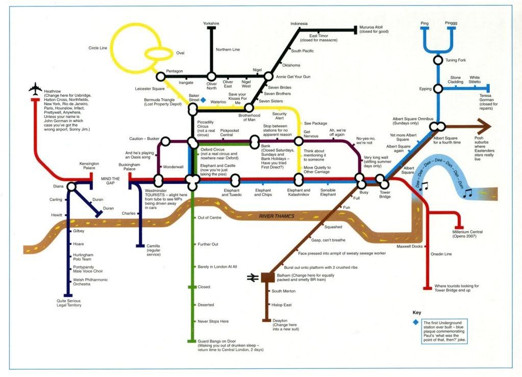
2051.My current obsession with TriMet Maps (and cosmopolitan transit map styling)(and ideas for map pastiches and parodies I've been mulling)(sorry about all the parens) invariably led me to the world-famous London Tube Map. You can get a look at the whole magila here (Transport for London guards the copyright with the ferocity of a lion, an ire I wish not to arouse ... the illustration right is sized really teeny, for illustration-y purposes). It's not only much loved and much imitated, it lends itself to a great deal of ... well, pastiche and parody.

By far the funnies one is a very simplfied map loaded with Brit-funnay that I understand only because of a steady multi-year diet of Britcoms (and a wife who's an Anglophile). It was orginally published in a BBC book called Have I Got 1997 For You, and I've found it displayed in quite a few places on the web. It's too good not to share, so I'll post the version I found on Craphound.com, and hopefully the copyright holders will view my disregard for the common weal with equanimity (click to embiggen):


Some of the things I don't quite get (such as the reference to John Gorman) but most of the stuff I do get, as I said, a steady diet of Britcoms over the past never-you-mind-how-many years have paid off.

Technorati Tags: , , , ,

29 April 2009

Alaska Airlines New Slogan, Reinterpreted

2046.Alaska Airlines' new slogan, North of Expected, is an awkward collision of subjective experience and a geographical verity. Once I heard it, it got under my skin and stayed there, and bugged me.

North of expected? Yeah, I get the play on Alaska being north and "north" also meaning above and beyond (what do they say in Argentina, I wonder? I'm expecting you guys to go above and beyond ...  I want the result to be south of what I expect of you!.

All I could think about being north of Expected was those little inset maps you got in the old Rand McNally Road Atlases, the ones with the simplified roads, and the squishy vague details:


As you can see on my map, Alaskaairlines is north of Expected, alright. Just north, as it happens.

There. I feel better now.

Technorati Tags: , , , , , ,

16 November 2007

[map_design] Shimmy Spill Regatta: The Anagram Map of Sacramento's Light Rail System

1120. More anagram map fun. This one I'm pretty sure nobody else has tried yet. It's PNG.


Here's the real deal.

PS: Yes, I just now realized that I left some things off. There will be a revision in near future.

Tags: , , , ,

14 November 2007

[liff] The LTD's Emerald Express, Anagram Version (or Eating A Stoat in Eugene)

1115. Found a rapid transit service nobody else has done yet to anagrammize; the L.T.D.'s "Emerald Express", better known as EmX:


You can see the real map of the route here.

The EmX is kind of like a rail line without the rails. It travels down a special road bed using speically designed buses. This road bed is separated from the rest of the road and is only open to the EmX buses so, once the EmX leaves the local street, it behaves rather like a rail line.

Just like MAX, the first line was built to the nearby community to the east. More to come, by the looks of it–on the west, naturally.

Technorati Tags: ,,,,

[liff] Salem's Rhetorics Transit System

1114. Rather late to the party, I know, but I, with some bizarre sense of pride, present the Salem-Keizer Transit ("Cherriots") Anagrammatic Route Map:


I started it a long time ago after seeing the fad erupt on BoingBoing and after PDX local phoblogger Major Clanger did a very witty one of our own MAX (of which, I'm still quite impressed, Major; you never acknowledged my compiment of you but know that I still admire your work on that map) and then dropped it for some reason probably relating to personal pressures. My bad there.

This map might be seen as version 1.0 of it; Since I wanted to bring it to a sort of finish right now, I did not rework the logo, but take it as ironic that, given who the largest employer in Salem is, that CHERRIOTS can anagram to RHETORICS. The map withal breaks the type a bit; all the other anagrammed transit maps are rail, which, of course, Salem has none of.

I did have to take some liberties. I tried to keep that restrained. The current online version of the Cherriots route map can be seen here, and from it, one can see that the extreme simplification of some of the names (the simple letter "D" for "D Street" for example), while apprpriate for the style, leave little room for anagrammatic comedy. In such cases, I included the street type (in the example I anagrammed "D STREET", making of it a RED TEST), mostly (but not entirely) including either the standard street abbreviation or as much of the full street type word as I had to (for instance, "CROSS" didn't anagram to anything, neither did "CROSS ST", but "CROSS STR" anagrammed to "CROSS SORT", which I found ineffably funny, as I've lived in that neighborhood in Salem.

Anagrams have ways well-known of delivering wild irony; I find it funny that a PORTLAND ROAD would be the hidden lair of DATA PORN LORD; I'd always suspected that CAPITOL was a C.I.A. PLOT, WHEATLAND ROAD does seem to lead to an area of HARD WETLANDS north of town; and being so long and straight, LANCASTER DR would seem to be a sort of SCALAR TREND. If, on the other hand, there are actually any LAMER COMICS living along COMMERCIAL, I have no specific knowledge.

Other liberties would be found in the route name list. I kind of played fast and loose with puncutation; to create the anagram for the 12th & Sunnyside route I left out the numbers and the ampersand and was thus able to SHUN DESTINY, and if I left the ampersand out of STATE & FAIRVIEW I was able to give it an AREA FIVE TWIST. A particularly difficult decision was with the SOUTH COMMERCIAL route; an early anagram was SCHOOLMARM CUTIE, but I went with THE CALCIUM MOORS because that has a destinational feel for it, and it's kind of surreal besides. Also, I liked the scrambling of ORCHARD HTS into TRASH CHORD so much I decided to make the route 10X the TRASH CHORD EXPRESS, it being equally absurd that there's a fast way to get to the place.

Technorati Tags: ,,,