27 April 2006

[design] Redesigning Cherriots: Part 3, All Roads Lead to Salem

Surf this for Part 2. There's a connection in Part 2 for Part 1.

When I last left the Cherriots System Map, I'd dressed it up a little with the Willamette River and a re-think to the way we put numbers on the route lines themselves. I think I've pushed it about as far as I can without adding things to it. Wholly appropriate to the last observation is remembering one of my primary logics in redesigning the map; to increase its utility to the user by tying it into its surroundings, incidentally increasing its utility to more than just transit map users.

So, creating a new layer in Illustrator, turning off all the other work I've done so far (it's invisible but it's not gone–layers are without a doubt one of the greatest paradigms implemented in digital art applications), I turn on the scanned Salem ward map I'm using as a template and begin to draw lines where the pricipal streets are. The detail of the diagram and my knowledge of Salem are of great help here.

After a bit of work, then, viola! (click it to see it bigly):
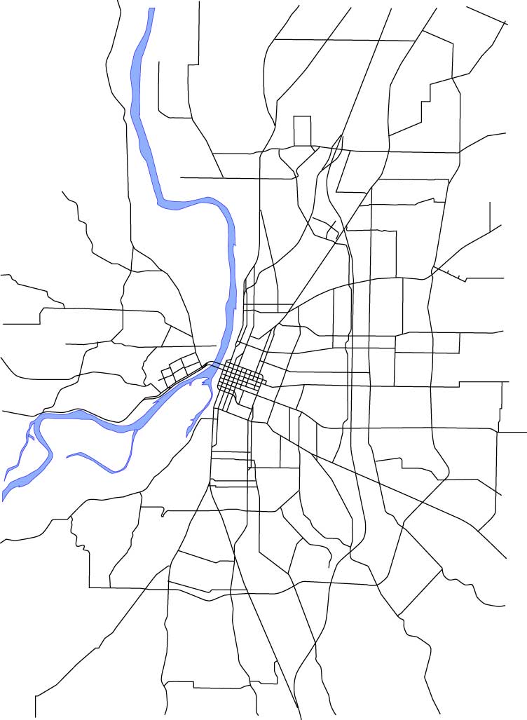
I've also always found the street layout around Salem very interesting. A standout is the way streets converge into Salem. Portland is a big grid that grew out to the east (think about it: the first north-south avenue that cuts all the way across town without having to jog over on a cross-street as you go east of MLK/McLoughlin is NE/SE 82nd Avenue, but I digress), but Salem grew up in the middle of a big spread of agricultural prairie, and the streets that converge remind one of an asterisk. Another notable feature is the Kuebler Blvd/Cordon Rd/Hazel Green Rd-Chemawa Rd-Lockhaven Dr beltline–which is a close approximation to the urban area's edge, which also closely corresponds to the limits of the Salem-Keizer Transit District's service area. The wishbone formed by Liberty Road and Commercial Street south of Vista Avenue is also just plain interesting.

With the Salem ward map and the main streets laid in then, it's time to get to one of the important tasks; aligning the route network to more closely actually follow the streets. The original map, if it will be recalled, took minor liberties; the Commercial/Liberty couplet along the 18-Keizer West line north of the city center does a gentle curve that doesn't reflect reality at all; the bend along all the routes north of city center doesn't happen in the same place; the loop at the east end of the 20-Airport P&R route is not only geographically incorrect as to its shape, it's way too large. Depending on that representation, you'll think you're going east of I-5 when in fact the line stays completely west of the freeway. Those are just a few examples.

I make a copy of the layer that contained all the old routes. This I do so that if, unlikely as that is, I mess up the copies that I'm working on (Illustrator makes it as tough as possible to screw things up, and Version Cue saves earlier versions so I can go back at any point, but it can happen) I can grab a new copy of the original and start working on it. Also, it means I'm working on paths that are just the same size and position (more or less) as the original, so I can see the difference I've made.

So, I get out the direct-select tool (the white arrow) and move points so the corners and turns go where they ought to. I also add and subtract points (those tools are under the pen tool–eventually I tear off the pen tool palette for more efficient access) as necessary.

Most of the way through, here's what I have now:
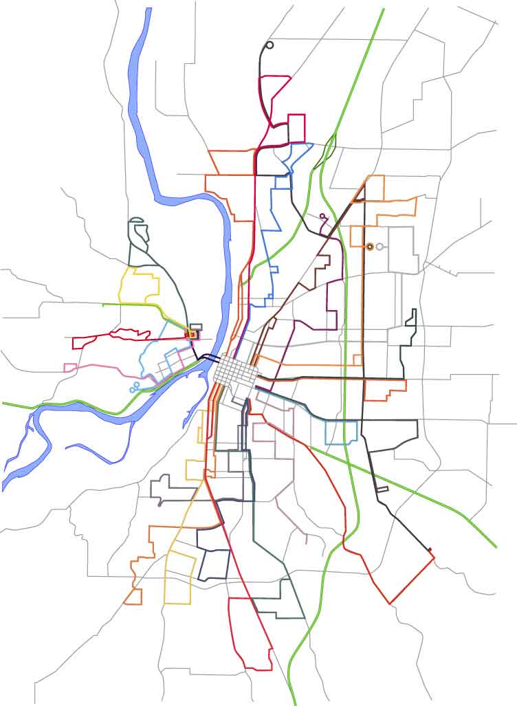
At this point I'm taking pauses to step back and enjoy what I'm seeing. I do like doing this sort of thing, and one of the romances of the transit map for me is there is a certain indescribable pleasure I get in seeing a city rendered in such an abstract yet realistic style. This is the sort of abstraction that maps do. You can't plot everything; a truly accurate map is a physical impossiblilty, that's what GPSs are for, and not even they get absolutely everything.

You'll notice the street network has been screened back–instead of strong black lines, it is now a network of gray lines. This is important because they need to be there to support the route information and must be visible but must not compete with it for your attention. You must be informed by it, but not distracted.

The difference between what is and what ought to be can be demonstrated by the closeup clipping that should appear just to the right of these words. The line 20 symbol is the blue green path that forms a square in the center-right of the illustration. Note that it overlaps the I-5 Freeway (the light-green with dark-green bordered line running vertically through the image). Remember that I plotted everything on the same scale, so if I took the original route lines and matched them to a correct base map appropriately scaled, it would be off just like this.
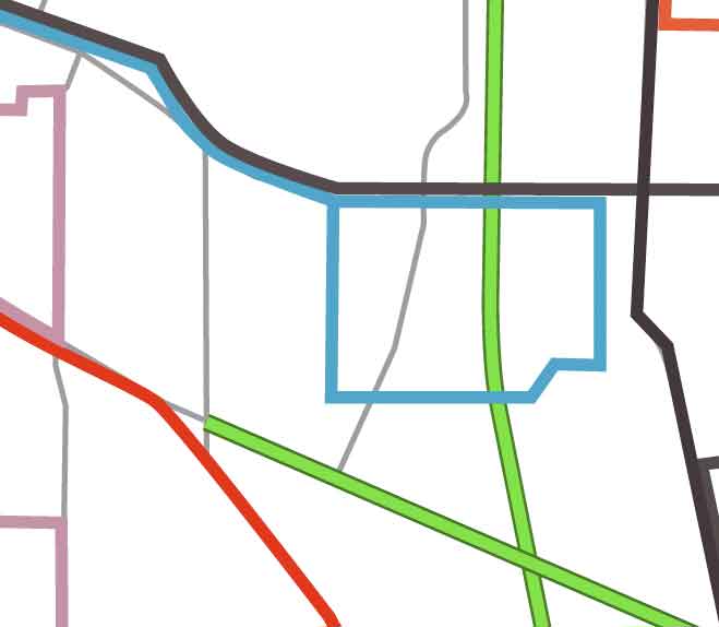
The actual route of the blue-green line should be down the gray line in the middle that curves down and to the left (that's Hawthorne Ave, SE) leftward just above the diagonal green line (that's Highway 22) on Ryan Dr, whichs is not on the map but whose location can be estimaed, and back up and rejoning the outgoing line on the next vertical gray line over (which represents Airport Rd, SE).

The appeal to a connection to reality may seem persnickety and pedantic, but remember, I'm out to connect this symbol to reality as much as possible. I believe it informs on the subconcious level–we recognize it even if we don't know it–and the end product will be much more useful.

One more thing I want to do a minor brag about: the green symbols marking expressways (such as Salem Parkway and Salem-Dallas Highway) and full-fledged freeways (I-5 and Highway 22 going east). These were made on a separate layer which was then locked (I didn't want to mess them up once I finally placed them). The lines themselves were made with a stacked path; The dark green path was given a 3-point stroke, copied over on top of itself, then then top line was lightened and given a 2-point stroke. This gives the appearance of a hard-edged wide line.

[net_life] Save The Internet, Update

Today a house committee voted on something called the "Markey Amendment", that is supposed to guarantee the net neutrality that preserves the net-as-we-know it...you know, the one where you can go anywhere without being diverted from or blocked away from sites and blogs that people who can spend enough don't want you to see.

The amendment was defeated, but not by the wide margin expected. This actually bodes well; once again people power closes the gap in a very measly span of time versus the long time and money you don't have that telcos have spent softening up the Congress. Save-The-Internet explains here. The battle is lost, but the war remains to be won.

Meanwhile, myDD takes an angry look at five DINOs whose loyalty to big checks from industry trumps thier stewardship of the public good and their notional commitment to thier consituents.

I've always felt that, given the reach and effect they can have on national public policy, everyone in America is a Congressmember's indirect constituent.

24 April 2006

[net_life] They Want Our Net

As b!x said, "Once upon a time, this was sort of a joke phrase". That was, of course, before corproations got thier hands all up in our business.

The Internet, this great network of networks, despite the flaws and and spam, still works pretty much the way it used to. Anyone can put just about anything up on the net that they want to, and anyone can come and see it, without someone getting in the way.

Well, they're busy trying to mess this up too. To big business in America, the world is just full of things they can't control yet or make money off of. And now they want to control what you see and make you pay extra to get what you really want.

In other words, if you like what isn't necessarily approved of by the big telcos or if what you like can't afford to pay extra then you get to see the world like I do...as though you were on dialup.

Grok the term network neutrality, move in with it, live with it, understand why it's important that it remain. And if you think it's just so much 'power to the people' lefty raving, let rest upon your brain the delicate fact that both Instapundit and MoveOn are in this one on the same side.

Then click the button below:


Or go to http://www.savetheinternet.com and read up.

We're for real here, people. If you don't get active on anything else, get active on this.

[design] Tutorial: The Whole Is Greater Than The Sum Of The Parts

Update 00:31 25-Apr-06: Designorati seems to be back up now.

Important Notice–Designorati off line:
as of this time (this update written 22:00 24-Apr-06) the server supporting Designorati has fallen off the face of the earth. These tutes really are there, so try again later, because they ARE worth your time.

Dig, if you will, the illustration. I'll wait.

Done? Good. I borrowed it from a post Jeremy Schultz, a graphic designer from West Des Moines, IA, and my colleague at Designorati, wrote. He's m4d wizardly in Photoshop, and this is proof.

This is actually the tale of two incredibly worthwhile tutorials he did. One shows how to use Photoshop's shrinking-violet sister, ImageReady, to do a powerhouse conditional action and saving it as a droplet. Droplets are cool 'applets' generated from PS and IR actions that live on your desktop, or wherever; just drag your files to them, drop, and they process. They're little robots.

Jeremy's tute about ImageReady conditional droplets is here. Go read it. It's good.

Now, as ki113r as that was, the image really made an impression with all of us at Team D:. It's the heart of graphic design, really; solving the problem of communicating, and oh, so deftly. We all asked Jeremy how he did it, and he decided it would make a jim-dandy tute on its own.

And it does. Go read it
!

It reminds of the importants of fundamentals, that true wizardry happens best when you use the basics to generate impact. Layers, Magic Wand, Spherize filter, brush palette. Not much more.

23 April 2006

[design, cartography] My Skepticism Is Noted In Indonesia

While hardly the most popular or oft-read blogger in these parts, never mind the world, I wonder how many of you can say that your words were assayed in Indonesia?

I'm serious about this. Please follow:

A few weeks back, following the ruckus generated when a Chinese attorney claimed to have found a map purporting to be drawn from information said to prove the chinese mariner Zheng He visited America and circumnavigted the globe about 70 years before Columbus first visited what we now call the West Indies, I wrote a short article.

After subequent testing of the paper, which is claimed to have verified the claimed provenance of the map (which I call the "Mo Yi Tong" map, after its purported drafter), the attorney held an invitation-only event where the findings were released. Predictably, the owner claimed that the scientific test, combined with various naked-eye examinations by experts, prove that the map was done at about the time that was claimed (1798 AD). This is felt, by the advocates, to lend weight to the claim that the map itself was drawn from a lost source that records the Chinese admiral's western hemisphere visits in approximately the year 1418 AD, on the Western calendar.

I wrote about that on Designorati:Cartography here.

The map itself suffers from a variety of stylistic problems which more learned experts than myself can articulately explain; the most glaring even to this layman's eyes are the representation of California as an island (which was actually widely regarded as incorrect when it was popular and is, on this map, nearly identical to its depiction on French maps of the day) and the peculiar two-lobed hemispherical display, which is apparently very much unlike the style that Mo Yi Tong would have been prone to acutally use (if we believe that Mo Yi Tong existed).

Most importantly, I feel that finding that the map may have been authentic, if we take this as true for the sake of the argument, proves little else than this map may well be authentic. The crucial link, that the map itself was based on authentic and true records of a voyage that have since gone lost, is neither proved nor disproved by Mo Yi Tong's authenticity. It's still a matter of faith, and is therefore a very weak link indeed.

The proving or disproving of that link is of, per se, crucial importance, since it is the rock upon which credence of the claim (which I call the Menzies conjecture, after the British author who made it popular with his book 1421: The Year the Chinese Discovered the World (the claim that the map was drawn from records dated 1418 also generate problems with this conjecture)) is based.

Anyway, I was Googling my own name and I found this link:

http://www.geografiana.com/dunia/budaya/peta_china_1418_otentik_1

which leads to an article on the Indoesian site Geografiana which makes reference to the article I wrote on Designorati analyzing the news of the authenticity announcment. I don't know any Indonesian (which I understand is a standardized version of Malay) but I believe that my conclusions are not exactly viewed with favor. The currency of the Menzies conjecture seems widely-approved of in eastern Asia, at least for the purpose of world-historical bragging rights, and in China, naturally, Zheng He is a national hero–all the more now since his name has been in the news of late.

The grown-ups remain unconvinced that Zheng visited the Western Hemisphere, and the weakness of the Mo Yi Tong map-based claim has not dissuaged the Menzies partisans from their position. From my layman's perspective, I find the Menzies conjecture interesting, but as a skeptic, I believe that such astounding claims require similarly strong proof–and it just hasn't yet been provided.

22 April 2006

[design] Redesigning Cherriots: Part 2, Old Man River

Surf this link for the previous step in the process.

Now that I have route number symbols, I find I like the look of the map better than before. I'm feeling now would be the right time to take the first step in connecting the route network to its envrionment; adding a symbol for the Willamette River.

It goes without saying that one important thing that almost every major Oregon city shares is the Willamette (minus obvious examples like Medford, Pendleton, K-Falls, Bend...). Including the River not only helps define the local geography in terms of the map but also helps the user subconcously place the location in terms of what they most likely know of the region. It forms an important basic connection to reality.

The Willamette follows an interesting path through Salem as well. Within the Urban Growth Boundary are two tracts of bottom land that were historically islands but aren't any more due to changes over time (Minto Island and Brown Island), and just outside it an island whose name is the same as an island in the Columbia off the North Portland Shore (Hayden Island). There's also a small island (McNeil Island) actually in the river along the North Salem stretch of the Willamette (I've not included it here for the moment).

It was fairly easy to trace (from an old Salem city council ward map I happen to have, that I scanned in and put on a template layer) an outline of the river and the small sloughs that connect to it. I gave it an appropriate blue color that I like, and I've always found a hard line graphically attractive, so I darkened that and applied it as a stroke to the traced shape.

Here, in toto, is the result:

The route list has also been backed up with a white box with a black stroke. I'll not be leaving it this way; it's not really readable in its original format, but I'm starting to experiment with it too. Leaving the river visible but ghosted appeals to me, as an artistic point.

The presence of the river instantly brings additional logic to the design. It's clear where West Salem is, it's obvious where downtown is, and it's apparent without having to read down into the design how the city aligns itself to the river. Also, since the towns along the Willamette typically have thier city centers along the river, the map becomes a pathfinding tool with more utility than merely illustrating the routes; anyone with an elementary knowledge of Salem can figure out how to go downtown or get uptown with knowing and logic.

Next we'll be putting in even more supporting detail; adding major streets. This is definitely becoming a labor of love.

21 April 2006

[pdx_geography] A Visit To The Willamette Stone

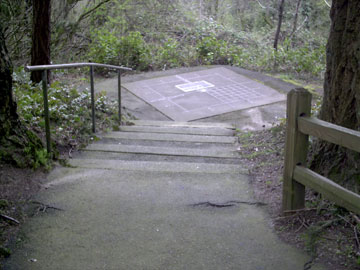
The picture you see on the right at the top here sits at the entry to one of the smallest and the most singular State Park in all of Oregon or Washington: Willamette Stone State Park.

For those who missed my pontificating on just what the Willamette Stone is, here's a quick recap: All real estate surveying in both Oregon and Washington references a single initial point of what is called the Public Lands Survey System. This initial point (and there are many of them for various regions of the US, this one governs Oregon and Washington only) marks the intersection of a base line (running E-W) and a meridian (running N-S) from which 6-mile-square townships are measured, tierned in townships north and south and ranges east and west (this system is sometimes called township-and-range). These townships are further broken down into 1-mile-square sections. This system, used throughout the west from its various bases, allowed the government to determine who owned what, where. All surveyed real estate, from Boundary Point in Washington to the driest, emptiest corner of Malheur County, relates to this point.

It's in Portland's West Hills, in approximately the 200 Block of NW Skyline Blvd, and it can easily be visited. The wayside is a wide area on the left as you go outward from the city center and is easily missed (it's right across from a house addressed 220 NW Skyline Blvd (I only provide this for reference, don't bother the nice people there, okay?)). From the roadside an asphalt trail leads down what becomes a bit of a steep slope. Stop at the entry and look on the right for a sign that explains all about the Stone and why it is where it is.

Turns out it started as a wood stake. Who knew?

The walk down the hill is nice but does get steep. If you're easily winded, take it slow and easy, and you'll get there...it's not quite two city blocks. What is magnificent about the park is that even though it is quite small, maybe 200 feet wide at its widest point near the entry at Skyline Blvd, there's been enough trees left that one can imagine what it must have been like when the first surveyors went up there to drive that stake. But why there?

I cut down the graphic for the sign pretty small and it probably can't be read, so here it is: the initial point was put there so that the Willamette Base Line should remain south of the Columbia River (closest it gets is out at Corbett, where it's scarcely a mile south of the river) and the Willamette Meridian should stay west of Vancouver Lake (which it does...just).

I guess they figured they'd have enough trouble surveying across the Columbia River and thorough the hills that they didn't need to do it across water.

As one traverses the trail downwards, it's very nice and natural, but big old satellite dishes can be seen easily through the trees to the right, and as one gets close to the Stone itself, the new houses of yet another West Hills subdivision can be seen in the near distance. We've come so far. About halfway down the slope, in the interests of safety perhaps, the State have thoughtfully provided the split-wood rails you see in the third figure.

But what does the end look like? Well, if you come upon the following scene:
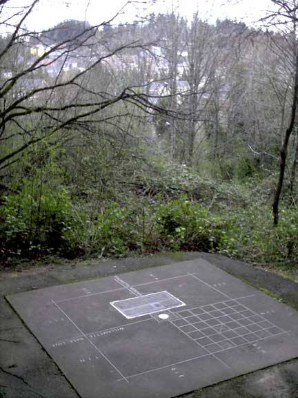
You're almost there. Ahead is a concrete platform, about ten feet on a side, a concrete (if you will) demonstration of what the Stone anchors and represents. In weathered brass are four large squares, and at the center of the interescting lines is a square containing a rough-hewn rock (which I think of at the Willamette Stone itself) and a bright steel disk with information engraved on. This is the Stone, the center of it all–or at least, the survey of an area the size of the whole of the nation of Germany.

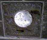
Close up, the Willamette Stone (and the monument) look like this:


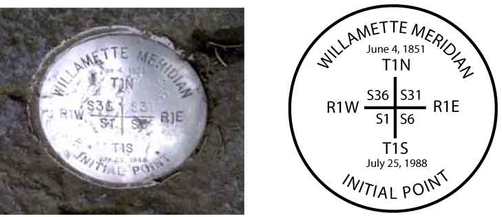
It is a little hard to see, so here's a diagram:

The information on the disk tells the tale of what the point means. The top date (June 4, 1851) was the date of the first survey. The plaque due south of the monument tells the tale of the monument and how it was defaced by vandals and replaced and dedicated by Vic Atiyeh (July 25, 1988).

Here's a better view of the setting:


This detail allows me to point out some salient features:

  • The Willamette Meridian is delineated by the centerline running from the lower right to the upper left of the picture, through the big inlaid brass plaque. This is true north-south. It is denoted with the brass inlay WILLAMETTE MERIDIAN.
  • The Willamette Base Line is delineated by the centerline running athwart that; that is, almost right to left. It is denoted with the brass inlay WILLAMETTE BASE LINE.
  • On the outside of the square, just visible in the resolution of the photo, are four inlaid notations: T1N (Township 1 North) and T1S (Townshop 1 South) closest to us and on the left; closest to us are R1E (Range 1 East) on the left of the centerline and R1W (Range 1 West) on the right.
  • From what we know we can be certain we are looking approximately south-southwest.
  • Knowing what we know about where the Multnomah-Washington county line lies, we know that the quarter of the square farthest from us (upper right in our view) is in Washington County, and we are standing in Multnomah County. The county line goes away south along the Meridian and west (to the right) alone the Base Line. Further, those houses in the distance are in Washington County.
  • The grid pattern we can see is a graphical representation of the pattern of 36 standard one-mile sections each township is ideally divided into.
Moreover, that horizontal line, running right to left, the Willamette Base Line, is also the line along which West Stark Street (and also SE Stark Street) was surveyed–that interesting street which we've spent so much time along lately.

There are few places more remarkable and reachable in Portland.

You are here.

19 April 2006

[art and artists] Slight Stumbles on the Way to Artistic Genius

A couple of faux pas:
  1. While the book Drawing on the Right Side of the Brain was quite educational, it was ultimately a failure for me; I could never get past the surgery part.
  2. Painting With Children was a similar travail; thier heads are too big, and they squirm. Also, the parents object.
(yes, it's a joke.)

18 April 2006

[design] Pushing the Envelope in Adobe Illustrator and Photoshop


The picture featured here is astounding. Gorgeous 3-D cutaway art, masterfully rendered in a style reminiscient of the best of its type. Give it a click and look at it close.

Would you believe this gobstopping bit of art was done in Adobe Illustrator, and colored in Adobe Photoshop? Neither did I, but it was, and it was God of Technical Illustration Kevin Hulsey who did it. The job itself was quite intense, but he came up with a tutorial that will scale down to the most modest of such jobs by concentrating on the concepts of the process. It's astoundingly simple for the results it garners.

In the case of this particular work, though, the particulars of the job were indeed titanic and I imagine are intimidating to even the everyday Illy user (I quail when I review them). The line art was produced in Illy and exported as a grayscale to PS where it was colored.

The Princess Cruise Lines' Empress of the Seas, then, by the numbers:
  • Final File Layers: 35
  • Final File Size: 1.3 GB
  • Time in Production: 920 hours
  • Export of the Illustrator grayscale file: 9 hours on a PowerMac G4 (clock speed not known)
The tutorial here details his work on the ship Radiance of the Seas, a slighly smaller drawing but accomplished using the same strategy and tactics. It's more of a demo than a tutorial, actucally, but it will give your brain the basic tools necessary to approach such a task, so you can get started trying things out.

It has high-resolution closeups of the image. You can almost imagine dancing on the dance floors, you can almost feel the pile of the carpets and the grain on the wood rails and floors, you can actually see full place-settings in the dining areas. With respect to the Empress, Hulsey faced certain challenges:

This project presented many unique challenges. The actual ship was still in Germany being completed when I started the project. There was no photography or CAD reference to work from, only the paper blueprint you see below. In order to have the brochures completed by the time the ship went into service, the final illustration had to be finished in under two months.

Yet another person I want to grow up to be. It's an advanced subject; if you aren't to this level yet, its something to shoot for.

Simply. Amazing.

(Credit where due: Veerle reported on it first, and I just stumbled on it when Googling for interesting Illustrator stuff)

13 April 2006

[design] Redesigning Cherriots: Part 1, Route Numbers

The first thing I wanted to 'play' with was the route numbers. In the previous chapter of this chronicle, I detailed the weaknesses with the presentation, and made particular mention of the route numbers, large size-numbers placed next to the lines themselves where space allowed, remarking that they looked like they were hunting down the street names.

Being so large they tend to take attention away from the routes and street names themselves; we say they compete with the other information on the graphic. In this case, they win, principally by intimidation.

The question becomes, then, how would I include the route numbers so they identify but don't sit on the map so uncomfortably. Fortunately, this is not a hard question to answer; years of development by other transit companies, in thier own informational graphics, show us the way. The system map at C-Tran is a good example; I rather enjoyed the way TriMet did it before thier redesign.

What I'm going to do is create what I call route-number icons. These will be small, reproudcible symbols that sit directly on the line itself. Done at the right size they can identify and draw the eye to the annotated subject but not crowd other information off. Also, this will encourage the eye to follow the line directly rather than having to glance off the line to make sure you're following the real one (that's accomplished by color at this point, but at some future point the designers may find it advantageous not to use color, so this option is now open for further developing the item).

After a little bit of experimentation, I came upon a graphic that pleased me and I felt communicated well. Check the following illustraton for a close-up view of the route-number icons in action:


The impression I get is one of distinct visual relief from the previous version. The informational usefulness of the work has increased a little. Attaching the route numbers directly to the graphical representation of the line itself brings your awareness right down to the line iteself and the street it travels on, which is one of the things that these maps are all about.

Another thing to point out here is one of the magnficent features of Adobe Illustrator CS2 (and previous versions, actually, but if you aren't running CS2, you're missing out), and that is symbols. Now, Illustrator is a vector drawing program, which means that each line is a mathematical expression that is stored as an object which contains all sorts of information about where the points lay and how the line between them is drawn/printed/displayed. One simple icon is no great problem, but when you multiply it over and over, drawings can get huge, and can cause problems even on the faster systems.

Symbols get around this problem by allowing you to store the object just once, but using that stored object to create as many instances as you need. It's like an ink stamp; the image is on the press but it creates copies on the page (of course, the metaphor here breaks down pretty quickly, in as much there's no link back to the stamp to break, but for basic practical purposes, it works alright).

I created the icon for each line by making a small rounded corner rectangle, filling it with the approprate color, setting the type for the number inside, grouping the two together, and dragging it to Illustrator's symbol palette. Whilst drawing, I held down the Shift key; this changed the original grouped object to a symbol instance automatically, thus saving a step. It was then a simple matter to drag as many symbols off the symbol palette as I needed (or copying the ones I had about) and drag them into position. Additionally I grouped the icons on thier own layer so I could play with them without messing up my earlier work, and also to move them out of the way to make visual comparisons.

Creating symbols out of these objects also allows me to export them and import them as a library, simplifying inclusion in other drawings. I'm also planning a couple of inset diagrams which I'm going to develop off of the main drawing then include, so this will be of use.

Here is the full map, with my improved route number icons:

12 April 2006

[Address_Nerd] West Stark Street At Miller Road

On the right, NW Miller Road, looking south at the West Stark sign; on the left, SW Miller Road, looking north at the same sign.

Continuing the grand tour of the westside's secret division from this post, so, dig, if you will, the above diptich.

This is another piece of West Stark Street, off Miller Road just north of the light at it's southern terminus at SW Barnes Road. This is the segment of West Stark that's farthest east of all; less about 2/3rds of a mile east of here, there's the Willamette Stone; just a thousand or so feet east of the light down at the bitter end of Miller, the SW Barnes Road Changes to West Burnside Road. You are on the edge of Multnomah County in more ways than one here.

The signage, apparently neglected by either adjoining jurisdiction, is handmade, presumably by a local, and affixed to the county line signs. The green color closely matches the blade colors almost universally used by either jurisidition, but the lettering is applied in a mildly amusing yellow (Go Ducks!, maybe?).

A notable fact is that this bit of West Stark is, indeed, on the Multnomah-Washington County line, dispite one laying, generally speaking, east of the other. Typically, motorists and travelers experience the county line as a north-south line, crossed going either east or west. South of the surveyed line of the Willamette Base Line (which Stark Street, both east side and west side, happen to lie on), this is a north-south line, running alone SW 65th Avenue (this is why the area around SW Borland and 65th, in Tualatin, has come to be known as "Meridian Park"; indeed, SW 65th in the Tualatin area was once known as Meridian Road).

Once the line encounters the Stone, though, it turns west, laying along the Baseline, for exactly one mile (one Range west), then one mile north (one Township), following the township and range lines for west nine miles and north nine miles. That's 18 zigzags, and gives the Multnomah/Washington county line it's unique 'look', as well as keeping Washington County on the east side of the Tualatin Mountains and the Willamette River well within Multnomah. And it's why after going a fraction of a mile west from Multnomah into Washington County one only has to turn north a fraction of a mile to get back into Multnomah again.

Now, take a look down West Stark:
West Stark Street at approximately the 7900 block, a few steps off the intersection with Miller Road

This is a view westward down West Stark, about 50 or 60 feet off Miller Road (just out of shot on the right of the picture is a pricey Suburban McHouse). Note how off in the distance, just as the road gets to the trees, the paving gives up. Tempting to follow, but not 50 feet up that track is the undoubted End Of The Road; an old sign tells the interloper in no uncertain terms that this is a PRIVATE driveway and should you even think about using this to turn round, well, lets just not go there, and another driveway which forks off to the right and down which exults via a sign proclaiming "100 NW Tuality Way".

By my reckoning, just beyond the crest of that hill in the woods is the beginning of the part of West Stark that crosses Leahy Road/90th Avenue, just east of St. Vinnie's. The first time we visitied this section of street, what looked very much like city-street-standard streetlamps could be seen dissappearing into the grove on a straight line; "How neat", though I, myself; an uninmproved road with streetlamps. Sadly, no.

One more remarkable factor can be seen by closely examining the nature of the pavement. Noted that the right side of the street (the one in Multnomah County) has been finished with a nice curb. The left, however, in Washington County, has no such amenity. My conjecture is that the county line runs along that left pavement margin; it aligns with the location of the sign in the first picture, which one can presume was placed dead on the surveyed county line.

This is a thing that tends to happen on jurisdictional boundaries (SW Ankeny Street was planned right on the boundary of a donation land claim, and only one side lived up to thier side of the bargain of developing it, so it turned out dinky, but that's another story); it could be a jurisdictional quarrel or just differing timetables, but the other side of a line like that is off-limits. Multnomah is only tasked with improving and maintaining one side of the road; Washington the other.

Next time I post about this unique street, I'll be commenting on the part that intersects Leahy Road/90th Avenue. Stay tuned.

11 April 2006

[design] Redesigning Cherriots: Prologue

Not too very long ago, one Stumptown-based British expat photo-blogger, name of Major Clanger, was insipred by the anagramming transit maps craze on Boing-Boing. He did a fantastic and absurdly funny mash-up of his own featuring MAX. Some of the station and area names are not just absurd but weirdly appropriate; "City Center" became "Nice Try, Etc." and Hillsboro became "Sob Hill, OR". Go here to view it.

I became insipred to do the same with a couple of more modest arrangements: Salem's Cherriots and Greater Eugene's LTD. In the middle of crafting (in Adobe Illustrator CS2) a duplicate of the extant Cherriots System Map online version, I got a bit sidetracked, however. I may, at a time in the near future, anagram a Cherriots map, but I hit upon something much more fun and mind expanding, at least to me.

Before going on, I'd like to show my work product (at that time) off. I'm rather proud of it. Click at it to look at it bigly;

It's a 93K low-quality JPEG that is 975px x 1240px. It should blow up to about an A4 sheet in size.

The aim, in my opinion, of a transit map, is quick communication. It ought to tell you, hopefully at a glance, how you need to use the system to get from where you are to where you want to be. This, IMHO, is its highest function.

What follows is a bit of critique. If the original designer is reading these words then please don't take any negative-seeming words personally; I'm designing to what I think a transit map should do and to my own tastes, governed by my lifelong love of the printed map (and a not-insubstational transit map collection from cities nationwide). The following observations are mine, and mine alone.

The Cherriots system map as extant does its basic job adequately, but I find it personally a bit unstatisfying to look at. The route network hangs in limbo connected to nothing and not at all connecting the viewer to the reality of the area it serves. It includes an absolute minimum of information; the only extra information are a star-in-a-circle (for "Major Transit Stop of Hub"), and a small bus-front view graphic identifying Park & Ride lots (none of which feature any information about the Park & Ride lot)

It seems very much probably the the type in the map is Helvetica Neue. Now, everyone's heard of Helvetica, but I'll bet nobody can point out an example. There's a reason for this: back when it was first released into the wild, in the 60's, it was an exemplar of that design outlook called the "Swiss School". Swiss design of the day seemed to focus on the functional, with an emphasis on clean, no-nonsense form. The face Helvetica appeared and took the world by storm; at the time it was a revolution in type design.

It became so popular, however, that it became ubiquitous, and then overexposed (just like Paris Hilton and Lindsay Lohan). Type carries mood and atmosphere, but when it's all over the place it becomes banal and unremarkable, and the coventional wisdom amongst typographers is that that is just where Helvetica is right now. Subesquently a font called Helvetica Neue was designed which has a little more warmth to it, but the ordinariness of Helvetica still speaks out loud and clear. Check the following illustration:

(Top, Helvetica regular; bottom, Helvetica Neue regular, as snapshotted from Apple's Text Edit. The fonts used are the ones I had available on my system at this time)

Close–nearly indistinguishably so. Anyway, and to bring my font-prattling to an end, the point isn't that Helvetica is eeeville, not necessarily anyway. There are fonts that just blare out loudly "I used the defaults on this and dove on in", and thanks to Helvetica's overexposure, despite the continued exisence of the need of such fonts, designers tend to shun it. I have no actual dislike of it, but even I sometimes call it Velveetica Overexposed.

Other typographical sins include a sort of disordered feel to the type, as though it's all jostling with the lines for position. The big, horsey route numbers look like they're out to hunt down the street names. Some street names sit awkwardly alongside the lines they identify, as do the line numbers aforementioned.

Now, some may debate me on this point, and I'll respect that, but it just seems a not-altogther fitting calling card for the transit system of Oregon's second-largest city. The more I looked at it the more the maps for Portland and Eugene's systems came up: polished (though I'm still not entirely thrilled at the new TriMet look it is consistent and carried off professionally). I particularly enjoy LTD's elegant map; they get a lot done with only one color.

It was about this time that I fantasized about how I would redesign the Cherriots system map if I were given the job. I started identifying things I would do differently and decided I ought, in this case, walk my talk. I have a version in work right now in Adobe Illustrator CS2, and over the next few weeks or so, I'll post versions of my work to put the process on display.

Design is a process, which in this case somthing line a "Choose your own adventure" book. I love the process, and I love sharing the process.

06 April 2006

[design_career] Toot! Toot!*: My How-To On QuarkXPress is on CreativePro.com

PreScript: I borrowed Jeff Fisher's horn for this. See bottom of post.

This
is a big deal for me:

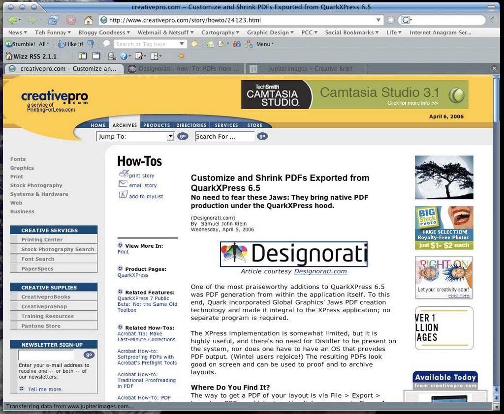
A screenshot of CreativePro.com's featuring of my QuarkXPress 6.5 how-to article on creating PDFs from XPress 6.5. Clickit to see it bigly; go here to read it.

The above graphic is a screenshot of CreativePro.com's homepage, the current featured how-to article. It's mine! The subject is how to go about creating PDFs from QuarkXPress 6.5.

This is a worthy topic. Before XPress 6.x, Quarksters had to either use Adobe Distiller or export the layout as a PostScript file and then feed that to Distiller. If you were using XPress 4.x (which, reputedly, most of the installed base still is) then you were running under Mac OS 9.2 mostly and things worked fairly smoothly (operative word here is fairly). If you were running XPress 4.x or 5.x then you were running in the Mac Classic Enviro and unless you also had a Carbonized version of Acrobat Distiller.

When faced with this challenge, I found the solution for getting a PDF from a QuarkXPress 5.01 layout was to export the layout as an EPS then feed that to Distiller. The resulting PDF was readable. Exhibited wierd behavior, but readable.

The biggest complaint people have about XPress 6.5 PDF exporting is that the Jaws PDF rendering engine (Quark offers you an Adobe-free route to PDFs, BTW) creates bloated PDFs. It does, if you accept the defaults. If you used the "Job Options" tab of the Export Options dialog, however, you can specify image compression options that reduce the size of your PDF drastically.

Drawbacks: QuarkXPress 6.5 can only output PDF version 1.4. It's good for many proof uses and might also be adequate for press, but you don't get the fancy-schmancy PDF/X standards that are becoming fashionable. This looks to be cured by XPress 7, which does support them, but 7 isn't out quite yet. Almost, but not quite yet.

Anyway! Creativepro.com is regularly read by designers nation- (if not world-) wide. It was flattering to have Creativepro ask to publish it, and I'm incredibly pumped to see it up there.

Postscript: as Fisher's Axiom of Self Promotion has it, if I don't toot my own horn, nobody else will.

[net_life] The BlogPatrol Report

Just a few funny search terms taken completely out of context. Remember these are simply search strings, lifted without respect to the author's intentions (as though we could find that out anyway...).

Quark Express Public Beta Password
You're joking, right? You get it by signing up. It's free! And the Public Beta will go dead on you on 3 May anyway. Jeebus but I swear, if you're Googling for passwords for a free time-limited application you really are scraping the bottom of the barrel. I mean what's next–looking for a h4X0rific way of getting into your own Yahoo! email? Hey, while you're at it, I've heard of this 1337-o-licious place called Myspace.com. Invitation only, but we'll see what we can do for you, you scamp.
Hillsboro's population in 80's
Big hair and Duran Duran LP's, just like everywhere else, I mean, GOSH!
idaho falls bel air subdivision

...and if you thought that was fabulous, just wait 'till you see what Idaho does to Beverly. Hills, that is; swimmin' pools. Movie stars.

yanni beating
Some would say that's a good start. Actually it's part of a new show on FOX, tentatively titled When Audiences Attack. What happened to John Tesh wasn't pretty. Remember, loves, it's all fun and games until someone gets hurt; after that, it's just fun.
no meaning text FPO
Yes meaning text FPO, it be meaning "for position only". Good grief but I hate having to get out the big crayon...
"Tom Peterson's" and Portland
...go together like pie and coffee. You want that haircut? You can't handle that haircut!
QuarkXPress 7 public beta 2 DOWNLOAD
Well, maybe it would if you wouldn't yell at it. And use a computer. And regardless of what you saw Scotty do in Star Trek:Save the Whales, that isn't a microphone, it's a mouse.

05 April 2006

[design] Quark: At Least We're All On The Same Page Now

This morning I recieved in my e-mail a notification from Quark, Inc. to announce that the Public Beta 2 of QuarkXPress 7 was available for download.

This, of course, was after I had actually downloaded the 116MB file.

On dialup.

56K dialup.

It took three days.

(On and off, of course)

And a couple of days after I wrote something up here about it.

Thanks, fellas.

FWIW, the Public Beta is set to time-bomb on 2 May 2006. This was one day after I had heard earlier. And, the buzz is that QXP7 will at long last be released sometime during late May, but I'm holding officially publishing something on that on either Designorati. com or QuarkVsInDesign.com until either a)Pariah finds out solid info about it first or b)I can get some sort of confirmation on it myself.

My money's on Pariah, of course.

[Address_Nerd] The Outer Limits of SE Francis Street

Dig, if you will, this picture. Also, if y'all'd be so kind, please get out the Guide of Thomas, and open it to page 630, and turn your attention to grid E3.

You there? Good.

One of the interesting things of streets in Greater Portland is that you'll find extensions of streets that emanate from the main part of Portland, whose structure sets the address and street pattern for the greater part of the three counties of Multnomah, Washington, and Clackamas. This picture depicts what I think is the farthest reach of any street from its base: SE Francis Street at about the 34600 block. You get there by going out to Oxbow Park; follow the signs all the way out past Gresham on SE (then NW, then NE, then SE again but it's a "Drive" after that) Division Street.

It's a beautiful wooded area, going down into a dale, and it feels like its about a million miles away from anywhere else (just like the prices on the sumptuous houses in the area...but I digress). It may indeed be possible that the street should just so happen to have that name, but a rather detailed examination of the maps in my collection shows that this bit of road very nearly lines up with the parts within the Portland corprorate demesne, or near enough that any other alignment would result in a similar name. Also the addresses of what few houses were in that area on Oxbow Parkway (a n-s street) were in the 3800-3900 range, which corresponds to where Francis crosses inside the city.

As far as I can see, this is the one street name which extends farthest out from the Portland base than any other (nearest other I can find is SW Vermont Street west of SW 209th Avenue in Washington County–check it out–this lines up even better than this does).

And what kind of landscape does one find out there? Tranquil. Almost fit for a Bob Ross painting:

SE Francis Street looking west from SE Oxbow Parkway. The speed is rated 25 MPH, but I dare anyone without an ORV to try even that fast.

04 April 2006

[design] Setting up QuarkXPress 7 Public Beta 2

Well, I did finally get QuarkXPress 7 public beta 2 downloaded and installed. It's looking slicker than beta 1 (check the Mac OS X doc icon and the file icon illustrated).

There's one thing you must be aware of. Your copy of the public beta will likely crash when launched. If this happens, try two things:
  1. The old standby: trash preferences.
  2. If 7 won't run after this, this is because XPress needs a "Preferences" folder to exist inside the application's home folder and the installer, for some reason, does not create it. Create a folder called "Preferences" in the QuarkXPress 7.0 application folder, and it should start up just fine.
Just one other remark for now: I just lurve that new file icon (.QXP). I'm getting a strong resonance with the old Mac OS 9 .QXP file icon here. I don't know how 7 will fly once it takes off, but someone over at Quark is finally paying attention to the style.

01 April 2006

[design] Quark: Of Logos and XPress 7 public betas

Fault Quark, Inc. for many things, but dont fault them for not getting busy when they absolutely have to.

The Winter of the Logo's Discontent

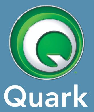
Some months ago, it happened, Quark finally brought to the public a redesign that was long in coming. Discarding the old familiar water lily in favor of a dressed down and modernistic majuscule Q, in Pantone 386 (renamed by Pantone "Quark Green"). It looked like a good move.

In nearly no time at all, though, the digital design community took it apart. Evenutally, rather far from appearing the canny move it was intended to be, it began to look like the biggest self-inflicted PR bruise Quark delivered itself since the Hardworking Clown/Valor Cross Media affair of October 2004.

Like or hate Quark, like or hate XPress, I don't see how any thinking person could have drawn the conclusion that the Quark PR machine was The Gang Who Couldn't Shoot Straight. I'm still scratching my head of the Hardworking Clown.

But Quark, no stranger to rising from the ashes, has come back with a new new logo. Welcome to the New Quark V2.0. Instead of an abstract shape (which some tend to confuse with a lowercase "a") we have a new badge which, in its full aspect (shown here) would look just as in place on the bonnet of a luxury car as it would on a software package.

Personally, I'm a fan of this go. The flat version (just the Pantone 386, no bevelling or lens flare) stands very well on its own and is an apt substitute with what they had before.

Just as with the Novermber 2005 logo, though, Quark has no shortage of ready critcism, but on style points this time. Commentary I've seen on the design cites the use of bevelling as being "amateurish" and the tiny lens flares looking like dropped pixels.

These of course are valid calls; they are indeed weaknesses that I wonder would have gotten past my community college instructors. The redesign is, I think, sound however (maybe they should have just come out with the flat version). It has a lot more going for it than against it, but living as it does in the wake of the rather embarrassing November 2006 identity rollout, it has to live that down just as QuarkXPress 7 has to live down the reputation of a company that claims it's found customer service religion.

You, Too, Can Get A Look at the Future of Quark

Another notable development in the Quarkiverse is the release of QuarkXPress 7 Public Beta 2.

At about the end of February, Quark announced somehing that the digital design community ha been waiting for, it seemed, almost since the beginning of time; the first betas of XPress 7 was not only released, but it was released to the general public. I've played with it and noted my reactions not only here but also on Designorati.

Long story short: I'm pleased with it, but it won't be the InDesign beater than some may hope for. But it will keep XPress in the game; for those who like this sort of thing, it should be just the sort of thing they like.

The first Public Beta was time-bombed; if you still have it on your system, it won't work now. Quark has, however posted the Public Beta 2, and it's a free download, but time-bombed to expire on 1 May. Still, it's a good idea to get your beak into this one if you're and InDesignista and wonder what you'll be missing, A Quarkster wondering if it'll be worth getting excited about, or just someone who wonders what the hell all this electronic layout brouhaha is all about anyway. Anyone with an interest can download the 116MB beta.

You can read about the program and sign up to play at Quark's site here.

31 March 2006

[pdx_geography, history] Damascus Gets On With It

I was fascinated by the front page of today's O, in no small part by the map which had pride of place and the front page story.

Reading the story, I couldn't help but think of the old joke where someone asked the dog that, now he'd caught the car, what he'd do with it now. Banal observation, I know, but consider: the City of Damascus, all 7-or-8-odd square miles and 15,000 (more or less) people of her, came into existence because of, essentially, fear and loathing of Metro brought on by the Urban Growth Boundary expansion. They wanted local control.

Before the incorporation, the questions of growth could, I suppose, have been framed as how to balance respect for personal property rights whilst preserving Oregon's biggest selling point–our quality of life (from where I'm sitting, it sure isn't economics). Different people might see it different ways, of course; that's not my point.

Now, Damascus, in search of more local control, draws a legal line around itself only to find that the decisions that might have been made on NE Grand Avenue now get made somewhere along SE Highway 212, and they're the same ones, only now it's up to them. The plan for the area was forged by a whole group of people over the past couple of years, and they still can't please everybody. Everyone agrees that we shouldn't screw up our countryside, but it tends to be real hard to find people who are willing to pay the price when the stuff hits the other thing. Now that there is a plan, they're all howling for running city government out on a rail already.

Although I'm not trying to cop a superior attitude here, I must admit to being amused, being a resident of a city who is cursed by everyone else in the state who doesn't live in it for "trying to annex the state" (whatever that's supposed to mean). Hammering out a new identity isn't for the squeamish.

One thing's for certain: Damascus stands to give us a good idea of 21st Century growth and planning and what directions and forms it could take, more than any other area mostly because they are forging an identity as a city. All us amateur (and professional) students of urban growth are going to be keeping a watchful eye on little 'ol Damascus.

I started off on this missive noting the map in the O. I was reminded of a post I made what seems ages ago about the new city limits of Damascus back in November of 2004. Having turned up the PDF of the Damascus city application and doing a little elementary editing, I came up with the likely limits of the new city. After seeing the plan boundaries I though I was pretty close, so, with the help of the O, I went to the homepage of the Damascus/Boring Concept Plan, and downloaded the map that had the current boundaries of Damascus (and a portion of Happy Valley)(Follow this link if you want to just grab the file). Here's what I found:


I'm quite satisfied to see that my estimation of Damascus's city limits was largely on target. There's a chunk of the southeast corner of the city that didn't go in, but other than that, pretty much dead on. Yay, me!

One thing I do find remarkable is the piecemeal annexations by Happy Valley up and down SE 172nd Avenue. I recall reading in the O sometime back that Damascus and Happy Valley were going to the mat over that area, and Happy Valley's strategy here is pretty clear: send out a shoot and pick off this lot and that lot along that shoot–much like some say Beaverton's trying to corral in Cedar Hills by throwing a stem out around it and then assimilating the resulting island. Happy Valley really wants that area along 172nd,it's pretty clear.

[news] Well, I Didn't Have Any Weekend Plans Anyway...

Oh, oh...


It's always something, innit?

More details (including a bulletin on the event) from the IEDAB here and here. Thanks to "Things of Interest" (formerly known as "Sam's Archive"...some other Sam, not me. But I do admire him).

And, before I forget, happy First of April, everybody.

28 March 2006

{Address_Nerd] The Far End Of West Stark St.

Dig, if you will, this picture.

A while ago, during the early stages of Nerdery, I pontificated at length on how the addresses run out in Washington County. One of the important things to note is that, unlike in Multnomah County, the line that divides North from South (NW from SW, in this case) is a surveyed one; in the main, no road follows it. At least, not largely.

The street name nominated to extend westward from the Multnomah/Washington County frontier was Stark. While we don't have a record of the decision, we can presume why. As a commenter then noticed, West Stark is laid out along the exact same surveyed line that SE Stark St does; it's a logical extension of the street name. Since West Burnside devolves into Barnes Road and which drops away to the south, this wouldn't serve as as ready a division as East and West Burnside do; Stark Street, as surveyed, is only five standard blocks south of where Burnside would have extended, so the difference is minor.

While the NW/SW division is largely invisible to the area resident, noted only by the changes in street prefixes and run of address on numbered avenues, West Stark Street does exist in one or two places (as well as some other street names found in unexpected places extended out from Portland into deep Washington County, but, ah, that's a tale for another post soon to come). There is a piece of Stark that the map claims extends west from Miller Road into the Leahy Road neighborhood near St Vincent's Hospital, but the map calls this "NW Stark St". Another bit, not too much farther west, crosses Barnes Road between the Cedar Hills Blvd signal and the crossing at Cornell and Saltzman. The map calls this "W Stark St", but the sign at the intersection calls it "NW Stark St" (I don't have a photo of this...you'll have to trust me on this one).

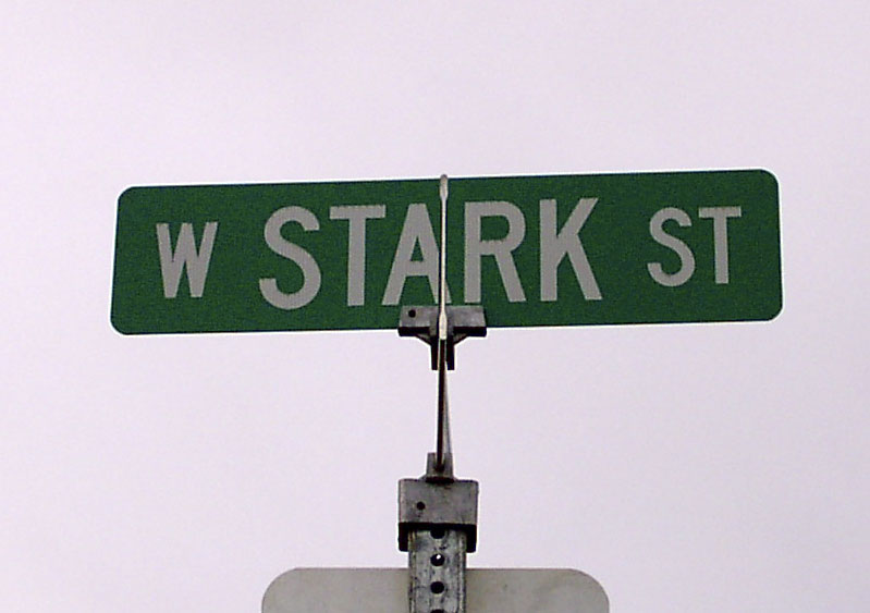
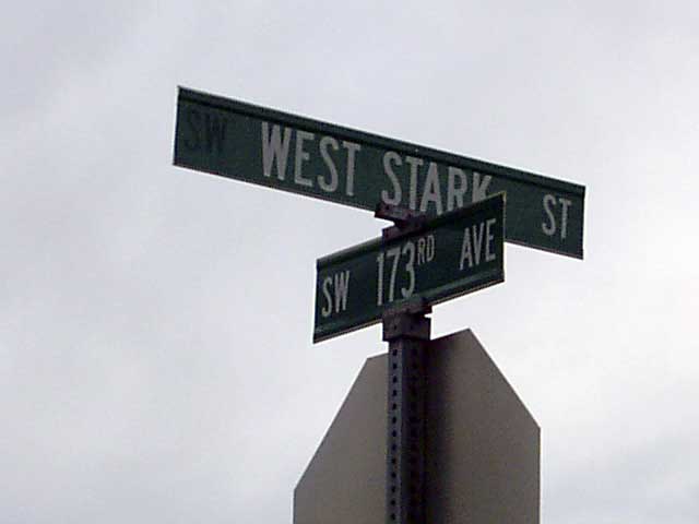
The other part of West Stark Street, and the most remote west section of it, can be found in Washington County, off 173rd Avenue between NW Walker Road and West Baseline Road. It's easy to overshoot but a street directly south of it, SW Nazaneen Drive, allows you to go in the back way via SW 175th Avenue (see the second illustration, which we took whilst stopped in the area where the red-on-white sign says, well...not to stop)

This part of West Stark Street only runs between 173rd Avenue and 175th Avenue (at least, the public part does). It's a pleasant street, in a neighborhood that has a mix of old farmhouses and new developments. The south side of the street shows the new development, including three micro-sized dead end streets called SW Parvenu Pl, SW Pasquirade Pl, and SW Palatial Pl.

You mind the Q's; looks like Washington County public works has the P's covered.

The north side of the street is only paved about 1/3rd of the way over; that side of the street has a charming white wood country-style fence with lovely manicured trees. It is actually quite a charming place.

The next photo has something telling in it. See if you can guess what it is before reading on:


Notice the asymmetry of the typography on the sign, and the unusual expansion of the directional: we typically don't spell out the word: that should read "W STARK ST". If one takes a good look at the blank area on the left hand end of the blade, one can just pick out the majuscule letters "SW". This blade once read "SW WEST STARK ST", and the SW was removed.

Credit to The Wife™ for getting the above. I had her doing Sherpa duty whilst I was out taking those pictures, and I was at the wheel of the car, and had her snapping away.

Indeed, there seems to be a bit of revision going on in that area. Baseline Road, long labelled SW Baseline Road to reflect its physical position south of the logical base, is being renamed on the signs to West Baseline Road along its entire length. We saw many signs that used to read SW, with a blank spot where the S should have been, and could trace the outlines of the freejack letter.

We're going back out that way, to visit the Cedar Mill Community Library, tomorrow; I hope to hit the Leahy Road area, and bring back some Stark Street signs from that trip, in order to fully document the thing.

West Stark Street, in the Elmonica area, facing east (toward 173rd Avenue) from 175th Avenue. The street sign at the right that can just be seen marks the entry to SW Parvenu Pl. In the distance can be seen the western flank of the Tualatin Mountains (the part of the West Hills that contain Forest Park and the transmission towers)

27 March 2006

[teh_funnay] Found Object: Henry's Windows XP Linux Review

From a post at "Henry the Adequate", current holder of the best. comedy. sentence. evar.:
It says "Press any key to boot from CD". After careful consideration I determine that the best key to press would be the spacebar.
Read the whole thing, if you dare:
Henry The Adequate: Henry's Windows XP Linux review

23 March 2006

[pdx_history] Malcolm X Street, ca. 1991

A couple entries back, in the entry I wrote about Martin Luther King Jr Blvd, special correspondent Alan DeWitt commented thus:
Do you happen to recall the unauthorized overnight renaming of Front Ave. to "Malcolm X Blvd." about that time? As I remember it, the pranksters relabled the street blades, the black historic district signs, and even the freeway signs over northbound I-5. Apparently there were leaflets that went along with the signs, although I never saw them.
Yes, I did. I remember, as I said, getting slightly irritated at the signs, but in a Address-Nerd-sort-of-way, not a social message sort of way. More on that in a moment.

Alan suggested a certain URL that laid the credit at the feet of a Reedie. I went exploring and found out a few things...

The evidence seems to suggest that the prank was the result of a then-Reed student named Igor Vamos. In 1991, either in reaction to or in commentary on the then-in-play MLK Jr Blvd imbroglio, he and a group of fellow-Reedies calling themselves "Group X" had white-on-green signs made up, in approximately the style of Portland street blades, that looked approximately like this:
(Well, actually, I was going to post an illustration of my own, but Blogger still has its head up its patoot and won't let me do it. Wish I had enough money to pay for my service, then I could complain. I was hoping to get permission to post the image to the 'blog, copyrights being what they are, but even if I did, Blogger wouldn't let me put it up...anyway...)

A graphic of then KATU-TV newsman Bandon Dunes (a/k/a That Exploding Whale Guy) with an actual photo of one of the signs in the Vanna box over his shoulder can be seen at this link (click on the photo captioned "A."-its on the left hand side, it should take you about a millisecond to recognize it. It clearly (well, about as clearly as a screen shot can, anyway) that the words "MALCOLM X" were in caps with the abbreviation "st" is in all lower case (not "Blvd" as some remember).

As an Address Nerd, my problems with it are thus:
  1. No directional. It should have been NW or SW, depending.
  2. The street type ("st") is in miniscules. Should be majuscules.
  3. If they weren't going to call it "Blvd", they Should have made it "AV", not "ST", anyway.
Igor has gone on to quite the heights afterward. Since graduating Reed, according to this piece by the Weak Willy, he went on to cultural jamming stuff such as the Barbie Liberation Organization and the most recent and fun version of his art, The Yes Men. We hear that he is not only a professor at Rensselaer Polyinstic Tehnitute in Troy, NY, as well as the recpient of a Guggenheim fellowship. Since he has parlayed screwing around into a highly lucrative position in academia as well as becoming something of a guerilla celebrity, we admire him. We are also insanely jealous, and think we hate him, but we're not sure about the hating part.

19 March 2006

[design] Three Thumbs Up!


A cool idea by Von Glischka, principal of Salem's Glischka Studios. Anybody can become a member, and members upload thier work (illustrative, graphically communicative), and work to improve thier technique.

Anyone, member or no, can view the TTU Gallery. This may make some famous designers.

Get good enough and you, too, can recieve the soon-to-be highty coveted "Three Thumbs Up!"

18 March 2006

[Address_Nerd] Portland Signs: MLK Jr Blvd.


(Street blade photo provided by Stan Kost, but Blogger still has its head up it's tookie, so no neat formatting. At least I get to show off Stan's work.)

In modern times, having a street named after the greatest civil rights and social justice pioneer of the last century is something of a fashion. If your town doesn't have a street named for Martin, it's the same as wearing brown shoes with your tux; it just isn't done.

This isn't to say that naming a street for MLK is trivial, though the way it's done sometimes seems to have more than the whiff of politics-for-appearances-sake about it.

Those who have lived in this area for a great long time know that, until the mid-80s, NE (and SE) Martin Luther King Jr Blvd was known as Union Avenue. Before the Great Renaming of 1891, Union Avenue was known by a number of names since, when East Portland was being first developed, it was the practice of the cities to allow developers to name the roads they were building pretty much anything they wanted (which was why the Great Renaming was necessary to begin with). Snyder has it thus:

This avenue originally had several names, on various segments along its length. in 1891, at the time of the Great Renaming, city officials decided there should be only one name on a single street, no matter how long it might be. The multiple names were deleted, and the entire length was renamed for the "Union", that is, the United States.
Therefore the first renaming of the street was of decided necessity.

The story of how Union Avenue became Martin Luther King Jr Blvd was one of percieved necessity. The following relies completely of my memory of how it was reported in The Oregonian of the day and is heavily accented by my own perceptions (I supported the idea and still think it was a good one).

By the mid-1980s the Northeast corridor along Union Avenue was in an advanced state of decline. Today various forces are attempting a commercial renaissance of the area; the jury's still out on how well it's going. But then, Union Avenue had a bad reputation as one of the meanest streets in our fair town, and if you wanted to get a wife for the night, that's principally where you went. Bad scene.
About that time, I can't clearly remember how, a groundswell of ideas began to happen on how best to rescue the troubled area. The idea of renaming Union Avenue and the median strip that currenly runs up that road were just two of them. As renaming Union to MLK gained traction, there was a great deal of arguing about it. Many of the merchants were against it, and a few well-known citizens, the most notable (some would say notorious) being Walter Huss, an archconservative populist whose name carried some weight in those days.

Eventually the pro-renaming faction (who I believe had the City's support) won the day, even despite an attempt to change it back from MLK once the name had been applied. In response to the feeling that the change had been somewhat forced down the throat of the people who didn't want it, the City drafted a set of detailed rules to bring about changes in city street names (which was then subsequently bypassed in a rush to rename SW and NW Front Avenue to Naito Parkway–but we'll be crossing the bridge, friends, when we get there), and for about five years people were treated to the sight of a very long "NE Martin Luther King Jr Blvd" street blade with hapless-looking "NE Union Ave" street blades perched atop them.

Now the Union Ave blades are all gone, and virtually nobody refers to it by that name anymore. Sort of lost in all the tear-up about it is the actual nobility in naming a street for such a worthy and noble man, whose example I think of when I think of someone who endured for what is right against the status quo. And the still-late-aborning rebirth of the meanest street of NE Portland (save for the place where Alberta Street crosses it) may not be the one that the name was hoped to inspire. And the median strip has done more to kill the MLK commercial strip dead than it has done to revive it.

But there are signs of life up there these days, and maybe someday soon MLK Blvd will run through an area that gives the name its proper due. Maybe.

Nota Bene: The "Union" name still survives: a short road fronting Delta Park, across outer MLK from the Jubitz Truck Stop area, still carries the name N Union Court, a name insipred by the old name of the major street that runs alongside. The street bends over the N-NE dividing line at that place, so its official directions is N, not NE.

Geographical Trivium: MLK Blvd runs north and south. If it were a numbered street, it would be NE and SE 4th Avenue. There does happen to be a SE 4th Avenue, in the industrial area between the river and the Grand/MLK Viaduct south of Stephens Street, and since the Bridgeton area alone NE Marine Drive has been developed, there is an extremely-high-addressed one- or two-block section of NE 4th Avenue, hard up against the north Portland shore.

[net_life} Yoda Apparently I Am

I try to resist the impulse to take those benighted What _____ Are You? quizzes because...well, they're just kind of stupid. But sometimes I can't resist...

...and I find out that this deranged script thinks I'm Yoda:

Which Fantasy/SciFi Character Are You?


Also, it turns out I'm different–just like about 113,000 other punters who got suckered in.

Click on the above image to go to the survey if you're so inclined. And my condolences.

16 March 2006

[logo_design] Quark Redesigns Again, Again

For all those who thought the first redesign of the Quark, Inc. logo was something "we knew they should have turned right at Albuquerque", we give you the New New Quark.

I think they should have bothered, and I think they've got a genuine article here. I call it evolution in action, and it was done the way they should have done it the first time; in-house. They recognized that Quark knows what's best for itself, and actually, given its past as the acme of creative applications, it's a mystery why they didn't do that to begin with. As my friend Pariah Burke said in his post on Quark VS InDesign:
The 2005 logo is still featured in SicolaMartin’s online portfolio as a warning to other prospective clients of the Austin, Texas firm seeking unique branding.

It'll probably take SicolaMartin a while to recover from this bruise, I wot...well, at least amongst creatives, anyway.

There have already been some negative reviews of the new new logo, but I don't agree with them. Maybe it has to do with stacking this new new look against the old new look and recognizing that it's a distinct improvment (it has character and style, the change to the tail of the Q make the typography look more polished, the dynamic tension caused by the concentric asymmetry, and the Q that actually looks like a Q rather than an "a"). But then Quark has been so insensitive and arrogant toward paying customers in the past it will always have some animus from people against it.

What's actually surprising is that it's so strong. Check out this post at a place calling itself "Things That Suck" . This is perhaps a little übercranky but the root is typical of the sort of anti-Quark sentiment I keep seeing as a writer at D: and QVI. Sour grapes? Maybe. But I've found when there's enough complaining about something then it's not always on the complainers–in other words, there's good reasons why there's so much moaning. They don't even care that Quark 7 is about to happen–and that's even after trying the public beta.

As one wise person I knew a while ago (who has since executed the function shuffle (mortal_coil, off) once said, "It takes ten "attaboys" to make up for one "aw, hell". I don't think Quark has worked its way past five yet.

But, over everything else, I think the re-rebranding is, at last, a success.

I guess the real question is: too little, too late?

15 March 2006

[artists] Thomas Kinkade Is Teh Suck

Doin' a little catch-up here. The comments I got on this post were quite good and got me to thinking, always a dangerous thing amongst amateurs.

Anyway! In the aforementioned post, we discovered that the vaunted "Painter of Light", Thomas Kinkade, has rather decided feet of clay (story from the LA Times, via Arts & Letters Daily). pril and Carla commented.

Per pril:
JMO here, but his stuff makes me ill
I just hate when you equivocate. Tell us what you really feel, won't you? After describing her revenge (go to the comments, it looks much better in context), she continues:
I don't mind that other people are fanatical about it, or even like it just a little bit, but I'll take the Pre-Raphaelite Brotherhood over Kinkade's stuff anytime, at least as far as luminosity and detail goes.
Or maybe even Maxwell Parrish, who, while not counted as a pre-Raphaelite, was contemporary to some of the later ones and certainly had his own way with light. Come to think of it, in terms of luminosity and style, Kinkade is probably what Parrish whould be like when you subtract passion. Public piety (he tends to make a meal of how Christian he is) and sentimentality are all well and good but art without passion creates paintings that are just like Kinkades–technically adept but hardly moving.

Carla had this to say:
Yup--gotta go with pril on this one. I find Kinkade's work contrived and uninspiring, personally. I would definitely take a Pre-Raphaelite work (or a 18th century Impressionist, for that matter) over Kinkade easily.
Like I said–unmoving. Cute, kitschy, but 100 years from now people will still be talking about certain artists, and I'm pretty sure that Kinkade won't be one of them. Maybe they'll refer to him dismissively, sort of an American Biedermeyer maybe. But that's about it.

Carla's last sentence gets the last word, because someone had to say it:
Sounds like the guy spends a little too much time insulated from reality.

Couldn't agree more.

14 March 2006

[design] Professional Designers Cry NO!SPEC

Spec? What is this Spec then?

"Spec" is short for "speculative". While there are many types of speculation the one that designers should be watching out for is the prospect of doing hard work for the hope of getting paid.

What sort of insane fool would do hard work for only maybe getting paid for it?

That's a fair question. The answer is, regrettably, rather a few (refer: "LogoWorks") . And it's not due necessarily to any moral failing on the point of the participants but, perhaps of the desperate desire to "get one's work out there" coupled with a healthy dose of good old American "gettin' soemthing for nothing".

Design is a serious business. Sure, designers get to do fun things and play with fun toys (maybe that's why so many people want to be one these days) but it's all toward a serious end: communication. Designers solve problems, and they've acquired specialized knowledge to do this.

One of the most egregious ideas of recent time is the "logo design competition". While there may indeed be times and places for such a thing, a trend has been emerging toward larger operations who should know better opening a logo competition as part of, say, a corporate redesign. Replete with the promises of "getting your work 'out there'" and "practical portfolio pieces", and the possiblity of a payday, such competitions gather work from hard working and hopeful designers the world over.

All these designers take time (a non-renewable resource) to come up with what is hopefully a stand-out design. And in the end, the client (the group running the contest) gets what might be an able design without the headaches of paying an hourly amount to a designer.

Win-win, right?

Wrong.

Here, for further edification, is a short list of the losers:
  • The losers. You might think this observation rather obvious, but think a little deeper: not only did the losers lose the competition, the effort, whatever research they did, and most importantly the time–all important things that professionals quantify and bill for–are lost, and everyone knows you can't get back lost time.
  • The winner. Sounds kind of insane? Think about it though; professionals bill by time, effort, and resources expended. The prize, while welcome, seems, by my informal watch on the field, likely of a value less than the money that would have been made by billing professionally. But, hey you do have a memorable piece right? Well, no maybe not. More on that in a paragraph or two. And do you have rights to your design any more? Maybe...maybe not.
  • The client. But the organization got a good deal, true, and they now have a well-designed logo, don't they? Well, possibly. Will it survive with the company? Maybe, maybe not.
The point have having a professional design your logo is that professional is in a defined relationship with you; you pay them, they are completely focussed on your needs, history, and culture. This is a level of relationship that a contest entrant can never have; they learn what they need to to represent you and once the contest is done, so is the relationship.

That contest oriented company might re-engage the designer to do futher work, but it's presumably likely that, having learned the lesson that if they need professional design work done, all they have to do is announce a contest and take the pick of the litter at a discount, they'll simply hold another contest. Whatever history of knowledge the previous designer had will simply not be accessable. The result of this is a company that undermines its own brands with a design strategy that is a hodge-podge at best. With branding, perception is reality, and if your public can't make a connection between you, your brand, and your brand's history, they won't remember you so well. There goes that good will.

Trust me on this: the layman may not "know design", but the layman certainly senses when they're not getting your best effort, and they act accordingly.

This begins a sort of circle of devaluation. Clients in search of a deal undermine the professional approach to design by creating a competive arena where desperate designers compete for work like gamecocks in a fighting ring which in turn convince clients that that's the best they'll expect or have to go out for.

We support professional design. We support stable, defined business relationships between designers and clients, which provide benefits for all. We support inspired and insightful design that adds value.

We cry NO!SPEC.

Epilogue: Memorable Great Logos

Saul Bass and Paul Rand are two names who have had a lasting, decades-long impact on not only American design but also the look and feel of popular culture. Between those two names have emanated the most memorable and influential logos in American design history, whether they are still in use or not. They have likely influenced and started more trends that can be counted.

Saul Bass created the following and well-known or remembered marks:
...and those are just three; he created the United Way logo, Celanese, and a host of them. The AT&T logo bears special mentioning; when it was still the Bell System (before the divestiture) his reductionist interpretation of the Bell logo was recognized by over 90% of the American public, and while AT&T has recently redesigned thier logo (check it out here) it still pays strong homage to Bass's own landmark redesign.

Now, I give you Paul Rand:
Classics, all. We all have reactions to seeing the ABC and IBM logos; they are as recognizable as the American flag, and timeless enough to have each survived decades of use. The UPS logo has recently updated as well (check that out here) but the shield shape is still there; Rand didn't design it, but he left his mark.

All those designs were created by paid professionals who knew what they were doing, without a hint of a design contest about it.

Something to think about.

13 March 2006

[us_politics] Finally...A Candidate You Can Trust

Here's one fella whose campaign I can really get behind.

Where do I sign up to volunteer?

[sundial_life] Dreaming of 10,000

Sometime over the last weekend, this humble 'blog notched its 10,000th visit (viewer, search hit, whatever).

Stand back. I'm growing fast. Watch out you big boys, I'll catch up to you in, oh, seven or ten years...

In the meantime, more in the offing. More street names, more logo talk, more of just me.

Ain't it Wonderful?

08 March 2006

[design] iPod, with More Cowbell

Ever wonder what MicroSith would do with the iPod's image if they, somehow, acquired Apple?

Patrick Corcoran somehow aquired a glimpse into this fresh hell of a Twilight Zone and, having done so, worked it out by designing the package. It's a look into an alternate dimension, a dimension of mind, a dimension of sight, a dimension where everything worth doing is worth overdoing.

Follow this link to view Patrick's vision.

(Via Designorati)

07 March 2006

[artists] I Should Have Posted This With The Kinkade Bit

Now Yanni's beating up on his girlfriend:

Read all about it at the Yahoo! News story here.

To me, the real revelation was that the fact that his real name is John Christopher.

How very prole.

I guess this is that center-not-holding thing going on.