
1754.
UPDATE: I have received at least one notice of a firewall not allowing the illustrations to be seen. If you are in that position, please check the illos out at my Flickr photostream here.
Council Crest, they say, is the tallest point in the City of Roses. It's got the best POVs. We love Council Crest, and if you don't ... well, son, there just may be something the matter with you that requires therapy.
Yes, I know those are harsh words. Sometimes the truth isn't pretty.
Anyway, we ascended the height recently with a camera. It was deemed nifty to try and get a picture of what was defined as the summit. Since Council Crest Park is a well-developed (and well-traveled and easy-to-get-to (even via TriMet – The #51-Vista bus stops at the bottom, at SW Council Crest Drive and Greenway Avenue) place, we wagered that a USGS benchmark could be found ... and we did find one, on the cement pad that supported the water tower. It was even market with a spray of white paint so we didn't miss it:

This is the standard USGS Benchmark monument; the obvious giveaway is the letters B.M. at the bottom of the disc. The symbol at the center, the triangle, is the more technical hint. When surveying from such a mark, the surveyor will position the transit so that the supporting tripod's plumb bob is centered in that triangle.
But, what's this? the area between the bottom of the triangle and the word FEET ... it's empty. Not only does it look like the elevation isn't there, it looks like it was never inscribed! Disappointing ... and strange. We won't find an answer here (though, if you followed the link to the Portland Parks page above, you know they say it's 1,073 feet (or 327 metres) above sea level ... still, it would have been nice to get The Offical Word™).
But that doesn't mean we left discouraged, no. There's much to see from the Council Crest Summit, things that are beautiful and just things that you linger over. And we had ourselves a nifty little picnic besides.
Now, I'm not a tree-hater, not in any way. But looking at this photo:

You can see maybe why I'd want exactly two trees to go elsewhere. Darn them, darn them all to heck! Though you can identify the legendary Big Pink (US Bancorp Tower) on the left there and the First National/First Interstate/Wells Fargo Tower on the right. So, not a total loss.
Also, NE Sandy Boulevard displays so well, it's hard to believe that the street weren't laid out with this view in mind:

The area where the buildings seem to widen-out, located almost square in the middle of the gap in the trees, is Portland's Hollywood district. If you look closely enough, just to the right of that spot and close by the tall evergreen, you'll note the Hollywood East apartment building, at 44th and NE Broadway. I think it's about 15 stories tall, and sticks out of the surrounding neighborhood rather remarkably, even at this distance.
Of course, there's always Mount Hood, which I can't stop looking at. I love that mountain.
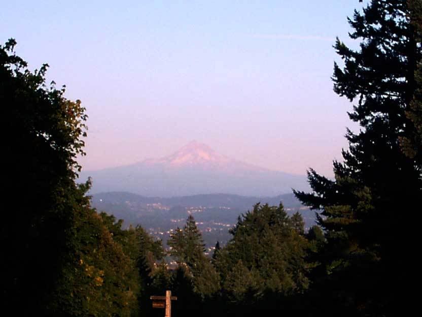
We would have liked more contrast (we had to geek this about in Photoshop a little bit) but that's what we get for trying to take a picture so late in the day. This was the purple mountains' majesty they were taking about ... atmospheric perspective turns things blue at a great distance, which goes to purple in the fading light. The lack of snow on the peak is of course indicative of the time of the year. Only the glaciers on Hood remain at this late summer time.
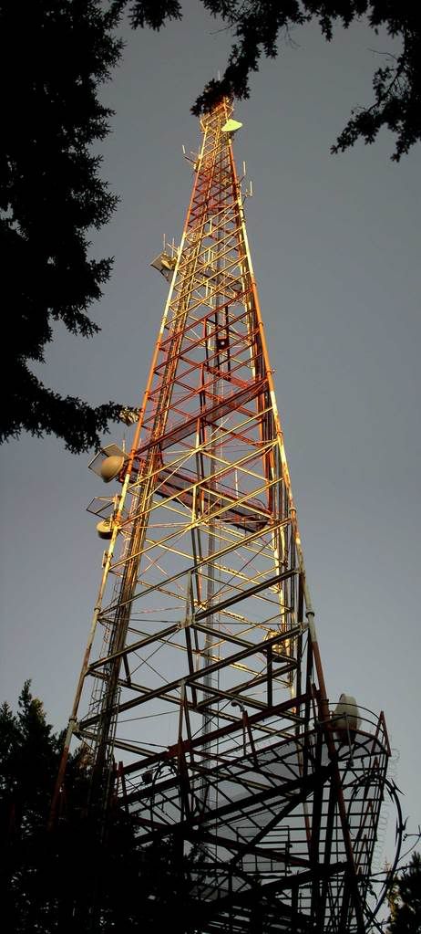 Actually, we weren't completely without success on elevations, and it was a bit of an accident. Being the highest point in the city, it's prime real estate for transmission tower antennas, and there is just the one there. It's been up there forever, it seems; there are bigger and bolder towers up there (the KGON tower comes to mind) but this one, as the reader can see, has a sort of restrained poise about it, sort of like the lady of the manor who has aged extraordinarily well.
We saw a new asphalt path leading off the circle going downhill and walked it. Not very long. It goes up to the gate that protects the shacks at the base from any drunken fool who has vandalism in mind (the fence is topped with razor wire! True story!). There are footpaths that go away down into the forest that looked very inviting.
But on that new alsphalt path, we have this:

This is a temporary benchmark. In the middle of that triangle is a very small piece of red tape held down by a steel spike, or a very large nail. This was the point the surveyor no doubt placed his plumb bob over. And the spraypainted EL. 1035 is no doubt our altitude at that point. Not the summit, as we at this point were downhill from that a bit (remember, the water tower is at the absolute summit).
And we don't know what kind of tree this is, but the way the setting sun seemed to set it aflame told us it was worthy of recording:

Next time, if the weather holds, we go up earlier.
Oh, and one other thing; I was surprised to find out that they now have telescopes up there (you may have seen one in one of the pictures). They cost 50 cents for a view that lasts a few minutes. But the one up on top, the one that gives the best view of Hood, just eats your money right now.
Tags: pdx_photo, portland photos, council crest, hollywood district, mount hood, council crest park
Powered by Qumana
6 comments:
Sadly, my workplace's firewall will not let me see any of the images. I get that lovely broken link, or what I like to call The Original X Box™.
Any chance for a Flickr mirror?
You got it, Stan. Check the top of the post.
welp. I don't know about how they do things in Peetown, but on the coast they white-ringed all the manholes a few years ago so that they could do an aerial inventory of where exactly all the stuff was.
"Peetown" ... LOL.
I have a feeling that it was done just to make it quick to locate. After all, the color of the disc is very close, value-wise, to the concrete.
longhand for "P-town". Of course.
Of course.
Still funny.
Post a Comment