
1791.
NB, Tuesday 20 Jan 2008: I noticed a lot of referrals here. If you have a few minutes, could you leave a comment saying where you came from and what got you here ... or at least where you came from? If this information helped you, then that's made my day Thanks!)
Today, we return to the 1928 Portland Hibernia Map to get another closer look. This time, we go back to Address Nerd territory.
One of the things that originally fired my interest in Portland geography was the complex (from my Silvertonian point of view) address grid. It was pleasing to the eye and easy on the ear: for some reason, saying Southeast Stark Street is intriguing to me in the way that simply saying Stark Street isn't. I like the way the letters S and W look when sitting next to each other on a street sign. Order in a directional quadranted grid is aesthetically pleasing to me.
But the idea of NE/SW/SE/NW/N had the air of an after-the-fact overlay, an artefact. So I started down the road of asking why. Eventually, I happened upon Snyder, and my questions were answered in the main, but knowing the basics I wanted to know more.
Eventually, after enough chipping away, old maps came my way in the cosmic way such things do. I learned about Portland geography before and after the Great Renaming.
As covered here before, Portland before 1933 was ordered in a different way, a thing that evolved from the merger of Portland, East Portland, and Albina in 1890 to form the modern City government and the need to bring a real wild-West style of naming (where developers got to name the streets in their new subdivisions whatever they wanted regardless of what names already existed elsewhere) under control. Names were duplicated willy-nilly across the entire city.
The plan that evolved formed the skeleton of the one we recognize today, but the nomenclature was different:
- All streets south of today's Burnside and west of the river were simply streets, with no directionals.
- All named streets north of today's Burnside and west of the river had no directionals; numbered streets were suffixed "North"
- The exception to 1 and 2 above was Broadway, which began life as Seventh Street and adopted the Broadway name after the Broadway Bridge was constructed and the street was extended over. North Broadway was Broadway north of Burnside; Broadway south of Burnside was South Broadway.
- Named streets on the east side were prefixed "East", but only if they had a counterpart on the west side. Downtown's "Stark Street" was called "East Stark Street". Named east side streets that had no west side counterpart had no directional (e.g. Thompson Street instead of NE Thompson St. Broadway was simply Broadway because the east side had it first; see number 3 above).
- Numbered streets on the east side were also prefixed East. What we today call SE 12th Avenue, for example, was known as East 12th Street.
- Numbered streets on the east side north of Burnside were, as on the west side, suffixed North, but still carried the East prefix for differention. What we today call NE 12th Avenue was known, therefore as East 12th Street North.
- There were 20 house numbers to the block, rather than the standard 100 that we know today. Between Front Street and First Street (no directionals, therefore the west side south of Burnside) the addresses rand 1-20. You didn't get to the 100 block until Fifth Street.
Now, for a couple of pictures. The truly exciting thing about the Hibernia Map other than its sheer age is that it contains information on how the addresses ran. Here's a section of the middle:
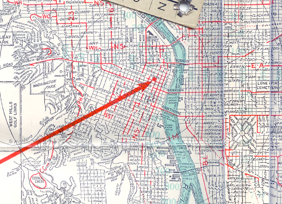
(surf this link to see it bigly in the Photobucket album). If you look closely, you'll see faded bold number in a sort of teal. Look near Lovejoy Street at the Broadway Bridge and you'll see the number "200". Near where Westover Road intersects Burnside, you'll see the number "800". This is how the address system ran in Portland in those days. An address in the 2400 Block of NW Marshall Street today would have been in the 800-820s on an un-directionalled Marshall Street. The Oregonian, at today's address of 1320 SW Broadway, would have been at about 280 South Broadway (speaking of location, of course; the actual Oregonian Building during those days was considerably farther north, in the middle of downtown).
Examining the map in full we find the highest address ranged only easterly into the 2200s (in the Montavilla area, around E. 82nd and E. Stark), southerly to about 1700 (Sellwood) and north along Union Avenue (today's MLK) in the 1500s. We assume that the addres schema increased going up the north Portland Peninusula into Saint Johns after descending to zero somwhere between Williams Avenue and Interstate Avenue, but the map is sadly silent on this point.
Now I did say that the address scheme was uniform thoughout the city. I'm afraid I told a little lie there. A curious thing can be found if we turn our attention south of Division and east of E. 41st, in the Holgate Blvd/Powell Blvd/Woodstock Blvd area:
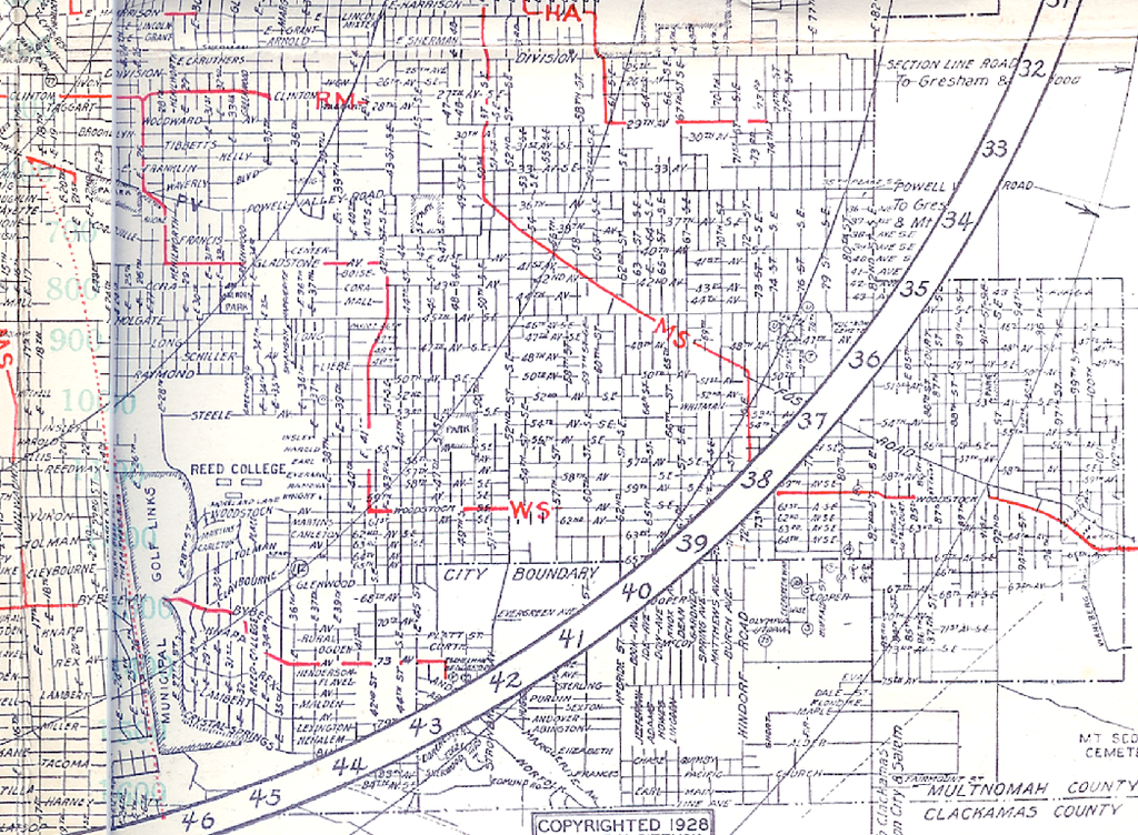
(you'll definitely want to look at the embiggened version by clicking here to Photobucket). Moving down from the top we see E. Harrison, E. Lincoln, E. Grant, E. Sheridan, E. Caruthers (these streets perforce extended names from the westisde core area), Division (no Division on the west side, remember, so no "E. Division", and then ... all names are replaced by numbers. And that's not all; the numbered streets run north and south whereas the numbered avenues run east-west (in 100% contrast to the modern Portland Avenue/Street pattern). And not just that, but this area shows awareness that, despite the house numbers, Holgate Avenue (for example ... today's SE Holgate Blvd) is 45 blocks south of Burnside, and therefore would be 45th Street SE (also showing awareness that the area is south and east of the address origin point.
There is very little written about this area or why just that area had the SE directional applied as a suffix. The only hint we have comes from pages 59-61 of Snyder, who relates that during the years when those who cared about such things were trying to dice out the rationalization of city addresses, particulary in the year 1910, City Engineer J.W. Morris advanced the following plan:
- All Street names to be replaced by numbers.
- Avenues to run east-west, Streets North-south.
- Burnside, the principal street divider, to be called Central Avenue. We surmise that the other divisions would likely be the ones we recognize today
- 100 numbers to the city block.
The plan was met with round disapproval by people who were conversant with, were fond of, and understood the sense of history inherent in the current street names. An editorial form the 24 April 1910 Oregonian had it thus:
Some people evidently don't know that there ever were pioneers! They would abolish the names on streets, and subsititute bare numbers. But a large number of citizens will not sanction this change.
We wonder if that outer southeast area was envisioned as a sort of a pilot program for this scheme. We do know that it was actually implemented: the curbstone at SE 53rd Avenue and Woodstock Boulevard serves as evidence for that (old street names are left in many areas of town preserved thusly. Next time youre at a streetcorner, look down. You might be surprised at what you'll find there (in the good way!).
It does speak for the merits of the plan that the basics of the thing – address quadrants, 100-numbers-to-the-block, and numbered ordered avenues radiating from the origin point – did actually form the basis of the current plan-on-the-ground that we all know and use daily. We don't know about our readers, but we rather prefer that names were kept on the streets, though, noting the latter-day compulsion of some to change names to honor notable historic figures, we wonder if going with the all-number system would have had a benefit of removing the pain we've seen in the news. After all, renaming 65th Avenue NE to Rosa Parks Way or 15th Street North to Cesar Chavez Boulevard would hadve turned out to a welcome change.
All the illustrations I've been using for this posting series can be seen in the Photobucket album, here.
Tags: Address_Nerd, SE portland, portland addresses, Portland maps, Portland history, 1928 Hibernia map
Powered by Qumana
8 comments:
These maps are fascinating! Thanks for posting them.
Here are some odd bits I noticed looking at the SW Portland portion.
Where Burnside Street goes into the west hills, it's labeled as Washington Road for a stretch before it becomes (became) Barnes Road. (Only the final "S" of Barnes is visible in the extract.)
Many of the roads shown on the map were paper streets only; the map was compiled in part (maybe entirely) from plat maps of subdivisions. Most of the grid west of the medical school was never built.
Where the Zoo and Children's Museum are today was then a golf course. A portion of the course survived into the 1960s as the "Hoyt Park Pitch-Putt Golf Course." It closed to make room for the World Forestry Center.
Finally, look at the Morrison Bridge. It connects the east side's Morrison Street to the west side's . . . Morrison Street. It was replaced in 1958 with the current Morrison Bridge, which connects the east side's Morrison and Belmont Streets to the west side's Alder and Washington Streets, missing SW Morrison by one block and leading to today's enigma of Morrison Street not running to the Morrison Bridge.
@ Isaac:
Where Burnside Street goes into the west hills, it's labeled as Washington Road for a stretch before it becomes (became) Barnes Road. (Only the final "S" of Barnes is visible in the extract.)
Good point. While I can't produce the refs right now, my reading into how Portland physically grew shows that the road westward past what we today call SW 15th Ave was actually considered an extension of Washington Street ... it evolved into the western extension of Burnside.
Even today you can see the legacy of that alignment. Travelling westward on Burnside as you cross I-405, there's a noticeable dogleg bend in Burnside as 15th is crossed. It's even noticeable on a map: at 15th, Burnside Street bends ever-so-slightly northward and has a west-northwest slant to it.
It's interesting to think that the main entry to Portland from the west in the old days dumped you down Washington rather than Burnside but then in city growth nothing is permanent. Just ask anyone from the 1980s who had a SW Front Avenue address (first "Malcolm X Street", then Naito).
Many of the roads shown on the map were paper streets only; the map was compiled in part (maybe entirely) from plat maps of subdivisions. Most of the grid west of the medical school was never built.
And that's true today. Most of the older gas station street maps of Portland I have show that entire grid up there. The Thomas Guides only included the built streets, but that was only until they were redesigned two editions ago to emulate the style of the Rand McNally Streetfinders.
I hate paper streets, I really do. Seems to me an outfit as big as RMcN could have an intern cruise Google Maps or something.
One of the books I have, Drawing the Line by the highly-excellent Marc Monmonier, explores the matter of paper streets. Some are included just as traps to snare other mapmakers cribbing from thier works. Some are included because they don't do the field checking.
I understand that may have been the reality of making mass-market maps. I don't have to like it tho.
Finally, look at the Morrison Bridge. It connects the east side's Morrison Street to the west side's . . . Morrison Street. It was replaced in 1958 with the current Morrison Bridge, which connects the east side's Morrison and Belmont Streets to the west side's Alder and Washington Streets, missing SW Morrison by one block and leading to today's enigma of Morrison Street not running to the Morrison Bridge.
It's also intriguing to see a Morrison Bridge that ran parallel to the Burnside rather than aligning with the downtown grid. I've long wondered why the alignment was changed, and since nobody ever wrote down that decision as far as I can find, I'm left with the realization that, on a map, it's a more aesthetically pleasing alignment. But that's just me.
I've got a little more of this map to explore, and then I may move into the rest of my collection. I have an armload of old Portland maps coming from this era, going through the 'gas station' map era. They are amongst my most valued possessions. They are the light I hide under a bushel.
Here's another fascinating thing about the 1928 map: it's a map of the City of Portland. Meaning not just that it's called a map of the City of Portland, but that, with only a very few exceptions, it doesn't show anything beyond the city limits. Outside the city, it's all white space except for traces of a few roads such as Skyline, Canyon, and Sandy.
There were a lot of roads outside the city, but it's as if the mapmakers were literalists: "This is a map of Portland, so we're not going to show anything that isn't in Portland proper."
And you're right about Burnside and Washington: in the good old days, Burnside ended at Washington Street; now, SW Washington ends at Burnside Street. (Actually, it ends at 14th Avenue, because I-405 cut off the westernmost bit of it.)
Thanks for bringing up those points, Isaac. You always make the most incisive observations.
With respect to the actual scope of the map, which seems to disregard anything over the city limits, if Snyder is any guide, minds just didn't range out like they do today. The same editor (I'm guessing) that I quoted (or at least one of the O's editors of the day) was aghast at the idea of absurdly-highly numbered addresses ... some as high as 7700, of all things.
One wonders how he'd feel if he were brought forward in time to find that near Sandy we have a SE 502nd Avenue ... and with addresses in the 80000's in the Government Camp area!
You also had this to day about Washington Street:
Actually, it ends at 14th Avenue, because I-405 cut off the westernmost bit of it.
It might surprise you to find out that you are both right and wrong about that. I was a little surprised at what I found out.
I have remembered that, due to my many transits through the area, I have seen just south of West Burnside, a sliver of a street that marked off a little, flatiron bit between the south side of Burnside and the buildings that currently hold, amongst other things, Fantasy Adult Video.
Yeah, it had to be said. Anyway.
That sliver of street is actually signed SW Washington Street. So, in a sense, SW Washington Street exists in that last block, or at least a vestige of such, between SW 15th and 16th Avenues.
HOWEVER ...
Going to the official record, those two addresses in the block, 1512 and 1520, are officially addresses on West Burnside Street (the Fantasy Adult Video shop's official address is 1520 West Burnside St.
Here's the tale of the record:
This page (at PortlandMaps.com) details by street names. We can clearly see that there is a slanting bit of SW Washington St that aligns with the part of Washington that's east of I-405.
However, this page at PortlandMaps.com clearly details that despite the name on the street, the addresses are all West Burnside.
So that last part of Washington does exist ... but just as a vestige. I expect it to be filled in eventually someday ... development is like that.
You're right! Now that you mention it I recall that little sliver -- and it is part of Washington Street even though disconnected from the rest of SW Washington downtown. I remember the area before I-405 was built, but not well enough to recall what westbound traffic on Washington did when it got to Burnside, or if it was diverted somewhere so as not to run headon into eastbound Burnside traffic.
Well, not sure where any of us came from, actually, but I got to your wonderful mapnerd blog after a long search for early Portland addresses. I just finished reading "On the Trail of the Lonesome Pine", and my 101 year old book has a name written in the front with the address "684 E. 11 North, Tr 0090 Portland, Oregon." Your site did it for me! Not only am I gratified to understand the address, your blog is a great read. Rarely do I get to see the word "embiggened" in print. Love it. Also love maps. My Dad was a surveyor and later draughtsman for PGE in the 50's, and he used to bring home waste blueprints and I'd color in the lots and make mazes of them. I hated the way the paper made your hands feel dry and the ink smelled so sharp and dull at the same time, but I was captivated by the map bug, just the same. Thank you for the great old PDX info,SJK. May you always fold it right on the first try!
Valerie: Thanks for the comment. Safe to say that it made my day...
Your compliments about my writing in general also received with gratitude. I aim to please, and I'm thrilled when I hit.
My obsession with maps has indeed been in strong force since my childhood. I'm pleased by patterns, and will lovingly gaze at cities whose patterns please me even if I've looked at them uncounted times before.
I'm especially gratified when my obsession with the way Portland addresses happened pays off for someone else. I especially like helping other people answering the questions that they never knew they had, especially the one engendered by the old book you have.
That book is so old, by the way, that Amazon doesn't even have it. NOw, that's old!
Thanks for stopping by. Your thoughts rocked me.
Post a Comment